广西灵山1936年6$\frac{3}{4}$级地震地表破裂带新发现
李细光1, 李冰溯1,*, 潘黎黎1, 聂冠军1, 吴教兵1, 陆俊宏1, 严小敏2, 李志勇3
1 广西壮族自治区地震局, 南宁 530022
2 广西机电工业学校, 南宁 530023
3 中国地质大学(武汉), 武汉 430074;
*通讯作者: 李冰溯,工程师, E-mail:libingsu@yeah.net

〔作者简介〕 李细光, 男, 1966年生, 2004年于中国地质大学(武汉)获构造地质学专业博士学位, 高级工程师, 现主要从事活动构造、 地震地质和岩溶塌陷等方面的研究, 电话: 0771-2868231, E-mail:hnouyang@163.com

摘要

1936年4月1日广西灵山发生 6$\frac{3}{4}$级地震(灵山地震), 为华南沿海地震带内陆地区自有地震记载以来发生的最大地震; 目前为止, 未见与该地震有关的地表破裂报道和研究。在防城-灵山断裂带NE段寨圩断裂高塘-夏塘-六蒙、 蕉根坪-合口等地新发现至今依然保留完好的地震地表破裂带, 在华南中强震构造区尚属首次。野外调查表明, 该地震地表破裂带全长约12.5km, 在罗阳山前总体呈NE向展布, 主要表现为地震陡坎、 张裂缝、 右旋错移冲沟水系等, 地表破裂特征及断错地貌情况显示出该地震地表破裂性质为右旋走滑兼正断。探槽揭露该断裂至少存在3次地震事件, 其中2次为古地震事件, 最新1次为灵山 6$\frac{3}{4}$级地震。这次地震地表破裂带的发现, 对灵山地震发震构造的探测具有重要的科学意义。

关键词: 灵山6$\frac{3}{4}$级地震; 地震地表破裂; 防城-灵山断裂; 寨圩断裂; 探槽
中图分类号:P315.2 文献标志码:A 文章编号:0253-4967(2017)04-0689-10
A NEW FINDING OF SURFACE RUPTURE ZONES ASSOCIATED WITH THE 1936 LINGSHAN M6$\frac{3}{4}$ EARTHQUAKE, GUANGXI, CHINA
LI Xi-guang1, LI Bing-su1, PAN Li-li1, NIE Guan-jun1, WU Jiao-bing1, LU Jun-hong1, YAN Xiao-min2, LI Zhi-yong3
1 Earthquake Administration of the Guangxi Zhuang Autonomous Region, Nanning 530022, China
2 Guangxi Mechanical and Electronic Industry School, Nanning 530023, China
3 School of Earth Sciences, China University of Geosciences, Wuhan 430074, China
Abstract

On April 1, 1936, an M6$\frac{3}{4}$ earthquake occurred on the Fangcheng-lingshan Fault. This event is the biggest historical earthquake on the coastal seismic zone, South China ever. But so far, no any findings about the surface rupture of this event have been reported. This paper is the first to find several intact surface rupture zones associated with the 1936 Lingshan seismic event, in the areas of Gaotang, Jiaogengping etc. on the northeast segment of the Fangcheng-Lingshan Fault. According to the field work, the surface rupture stretches to 10km and distributes along NE direction in front of Luoyang Mountain, represented by earthquake scarp, extensional fracture, dextrally faulted gully and river system etc. The characteristics of surface ruptures and faulted landforms indicate that the surface rupture is of normal-dextral strike slip faulting. The trenching on this fault exposed that at least three seismic events have been recorded, including two historical earthquake events and the latest one is the 1936 Lingshan M6$\frac{3}{4}$ earthquake. These surface rupture zones are the key to the detection of seismogenic structure and the re-estimate of magnitude of this event. The new finding of these surface rupture zones would be particularly significant for the detection of the seismogenic structure of Lingshan M6$\frac{3}{4}$ earthquake.

Keyword: the 1936 Lingshan M6$\frac{3}{4}$ earthquake; surface rupture; the Fangcheng-Lingshan Fault; the Zhaixu Fault; trenching
0 引言

地震地表破裂带是震源断层错动在地表产生破裂和形变的总称, 一般6.5级以上地震容易产生地震地表破裂(Bonilla, 1988; Wells et al., 1994; Coppersmith et al., 2000)。前人对发生于国外(Yeats et al., 1997)及中国西部强震构造区7级以上地震(邓起东等, 1992)的地表破裂研究较多, 如1931年富蕴地震(杨章等, 1980; 徐锡伟等, 2012)、 2001年昆仑山8.1级地震(徐锡伟等, 2002; 李海兵等, 2004; 单新建等, 2005)、 2008和2014年新疆于田7.3级地震(徐锡伟等, 2011; 沈军等, 2013; 冀战波等, 2014; 李海兵等, 2014)、 2008年四川汶川8.0级地震(李海兵等, 2008; 周荣军等, 2008; 马保起等, 2008; 徐锡伟等, 2008)以及2010年青海玉树7.1级地震(孙鑫喆等, 2010; 石峰等, 2010; 张军龙等, 2010; 陈立春等, 2010; 潘家伟等, 2011; 程丰等, 2012)等都有地震地表破裂的相关报道。而华南地区属于中强地震构造区(任镇寰等, 1998), 由于强震较少, 雨水作用及人类工程改造活动, 很难保存地震地表破裂遗迹, 仅有的几次6级以上地震, 如1631年湖南常德 6 34级地震(董瑞树等, 2009)、 1969年广东阳江6.4级地震(钟贻军等, 2003)等, 目前未见地震地表破裂的相关报道。

1 新发现的地震地表破裂带遗迹

1936年4月1日广西灵山县平山镇东南罗阳山附近发生 6 34级地震(任镇寰, 1996), 造成101人死亡, 263人受伤, 此次地震是华南沿海地震带内陆地区自有地震记载以来发生的最大地震。前人对该地震的研究也仅限于地裂缝的调查(图1b): 陈国达(1939)等认为该区地裂缝主要为展布于根竹水至六俄一线的峭壁裂缝, 及沿罗阳山前平山至六俄一带发育的山麓裂缝; 任镇寰(1996)等认为2个地裂缝带整体呈NE向展布于平山-尖山一带的沙梨江(钦江上游)地裂带及呈NNW向展布于泗州-根竹水一带的泗州地裂带。

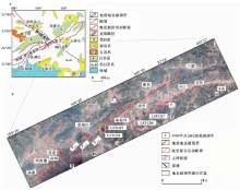
图1 区域构造简图(a)及地震地表破裂展布位置遥感图(b)Fig. 1 Regional structural sketch(a) and remote sensing image of earthquake surface ruptures(b).

本次在广西灵山县东高塘-夏塘-六蒙、 蕉根坪-合口等地新发现地震地表破裂带遗迹, 较好地记录了灵山 6 34级地震活动, 且与陈国达(1939)任镇寰(1996)报道的地裂缝带的分布范围和展布位置不同。

该地震地表破裂带在区域上位于防城-灵山断裂带NE段的灵山-寨圩一带(图1a), 沿罗阳山前NE向的寨圩断裂南支F1-2 及与其近平行的镇安-寨圩断裂F3展布, 两者相距700m左右, 在高塘-夏塘-六蒙、 蕉根坪-合口等地断续出露, 总长约12.5km(图1b)。

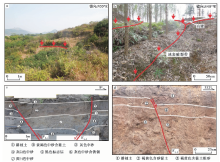
沿F1-2 断裂, 在校椅麓南山前台地上可见高约0.8m的阶梯状地震陡坎(图2a), 总体走向N55° ~60° E。在夏塘村东1.1km处山梁槽地(海拔162m)上发育总体走向NE的2支破裂带(图2b, 3), 南支主要表现为高约25cm的地貌陡坎(图3, 5), 北支由2条宽20~30cm的张裂缝和高20~50cm的阶梯状陡坎组成, 向SW延伸遇山梁分支成3条次级破裂, 绕过山梁后与南支会合成1条主破裂带, 结合地表出露的地震陡坎和被右旋错移的冲沟等断错地貌标志(图3), 判断该破裂带具右旋走滑兼正断性质, 探槽开挖表明它们是灵山地震活动的结果。沿F3断裂, 在蕉根坪-合口一带地表破裂带主要表现为地震断层, LSTC06和LSTC07 2个探槽(图1b; 2c, d)揭露出近乎切到地表的地震断层: LSTC06探槽揭露的断裂F3-1 和F3-2 同时断错耕植土以下的所有地层; LSTC07探槽揭露的断裂F3-3 断错了深灰色耕植土以下的地层, 耕植土地面的垂直位移10~15cm。综合该地表破裂带在罗阳山前断续出露的如夏塘村东1.1km山梁槽地处地震裂缝、 陡坎及地震断层右旋错移冲沟, 校椅麓南山前台地处地震陡坎以及探槽LSTC01、 LSTC03、 LSTC06、 LSTC07等揭露的同震地表破裂现象, 推断该地震地表破裂带具右旋走滑兼正断的性质。

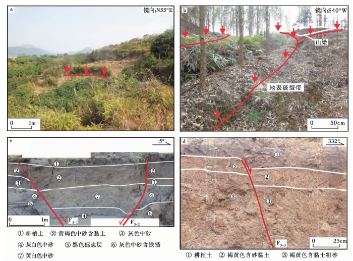
图2 地震陡坎(a)、 地裂缝/陡坎(b)、 探槽LSTC06/LSTC07地震断层(c, d)Fig. 2 Earthquake scarp(a), earthquake fissure/scarp(b), earthquake faults(c, d)exposed by trench LSTC06/07.

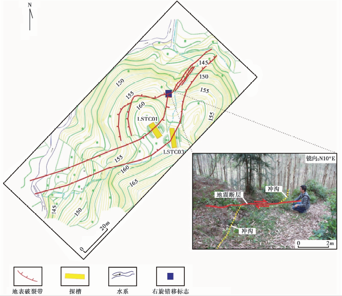
图3 夏塘村东1.1km处地裂缝/陡坎、 探槽分布图及右旋断错冲沟Fig. 3 Earthquake fissure/scarp, trench map in 1.1km east of Xiatang and dextrally faulted gully.

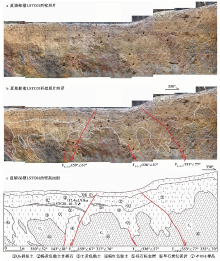
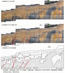
为进一步验证和研究地震地表破裂带, 在夏塘村东山梁槽地南北2支地震地表破裂带上分别布设了LSTC01和LSTC03探槽(图1b)。探槽LSTC01揭露了6套地层(图4a-c), 这些地层位于罗阳山西北麓的山前侵蚀残留台地上, 海拔高程为150~160m, 属于钦江上游的Ⅱ 级阶地, 区域上与桂林溶洞层对比可认为其形成年代为晚更新世-中晚更新世(钟新基, 1981; 周本刚等, 2008)。综合LSTC01和LSTC03探槽中光释光(OSL)样品的测年结果, 推断地层①、 ②、 ③、 ④的时代分别为全新世、 晚更新世晚期-全新世早期、 晚更新世中晚期及中晚更新世。探槽同时揭露了F1-2-1、 F1-2-2、 F1-2-3 等3条具正断层性质的断裂(图4a-c): 断裂F1-2-1 依次错动地层④、 ③、 ⑤、 ②、 ①及基岩⑥, 垂直断距20~40cm; 断裂F1-2-2 发育在地层③和基岩⑥中; 断裂F1-2-3 错动地层③、 ②及基岩⑥, 微地貌上形成高约20cm的断层陡坎。探槽LSTC03揭露了10套地层(图5a, b, c), 综合LSTC01和LSTC03探槽中光释光(OSL)样品的测年结果, 推断地层①、 ②、 ③、 ④时代分别为全新世、 晚更新世晚期-全新世早期、 晚更新世中晚期及中晚更新世。探槽揭露了F1-2-4、 F1-2-5、 F1-2-6、 F1-2-7 等4条断层均具正断性质(图5a, b, c): 断裂F1-2-4 错动地层④、 ③和基岩⑥, 垂直断距10~15cm; 断裂F1-2-5 错动地层④、 ③、 ②和基岩⑥, 可见由混杂黏土与砾石构成的构造楔状体⑦, 向上错断砾石标志层⑤, 形成崩积楔⑧, 并在微地貌上形成高约25cm的断层陡坎; 断裂F1-2-6 从基岩⑥向上错动地层④、 ③, 对地层②有一定的扰动; 断裂F1-2-7 切过基岩⑥和地层④, 对地层③有扰动。根据探槽揭露的地层错动情况, 推断该断裂带至少存在3次地震事件, 其中2次为古地震, 最早1次表现在F1-2-4 和F1-2-7, 主要切错地层④, 可能影响到地层③早期; 第2次古地震以断层F1-2-6 为代表, 发生在地层③堆积之后, 也可能在地层②堆积初期; 最新1次地震事件为1936年灵山 6 34级地震, 此次地震造成2个探槽所在位置上的断层陡坎微地貌, 以及坎前堆积层⑧。2个探槽揭露的断层在浅部表现为正断层, 它们可能与深部右旋走滑断裂共同构成负花状构造。

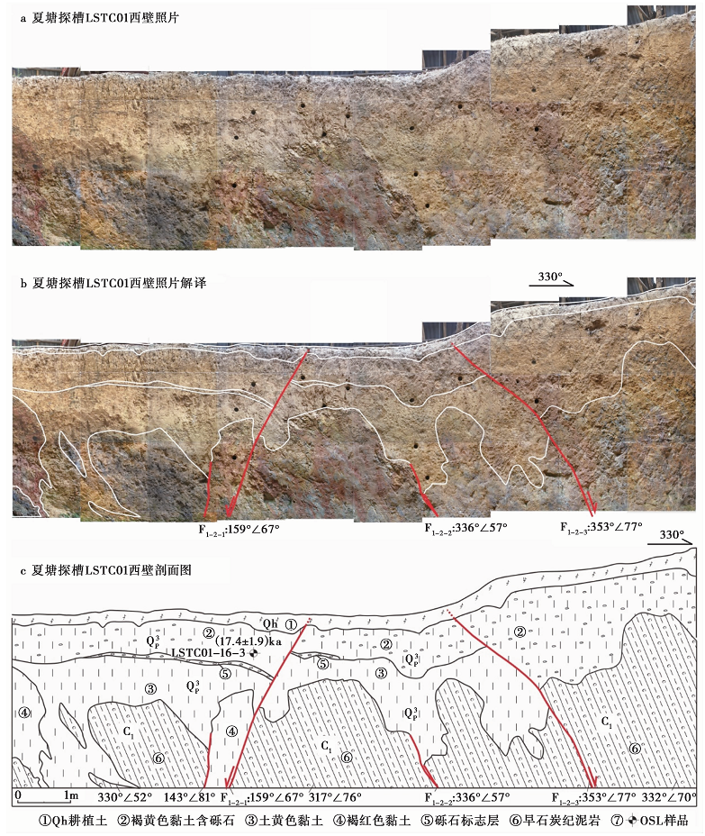
图4 夏塘探槽LSTC01照片(a)、 照片解译(b)与剖面图(c)Fig. 4 Photo mosaic(a), image explanation(b), cross-section(c)of Xiatang trench LSTC01.

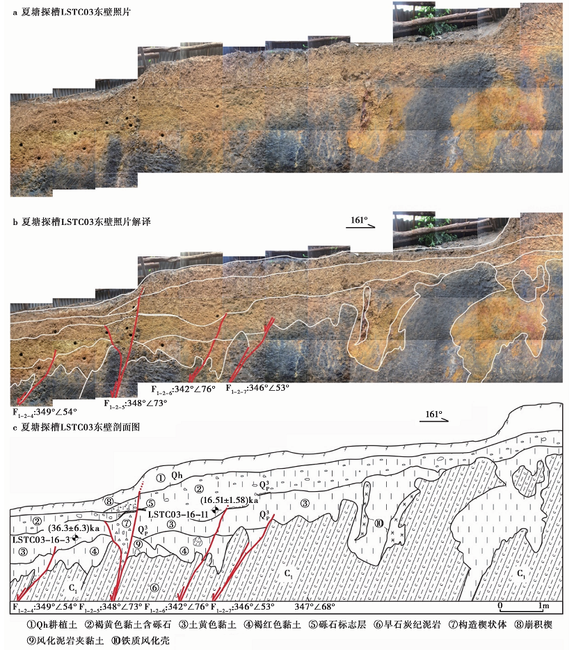
图5 夏塘探槽LSTC03照片(a)、 照片解译(b)与剖面图(c)Fig. 5 Photo mosaic(a), image explanation(b), cross-section(b)of Xiatang trench LSTC03.

2 结语

本次发现的地震地表破裂带在华南地区尚属首次, 对灵山地震发震构造的探测及其震级的重新厘定、 桂东南乃至南海北缘地区现今构造应力场、 深部构造及地球动力学的研究, 广西及邻区地震危险性评价、 地震监测预报及震害防御等具有重要的科学意义。下一步我们将继续对探槽揭露的地层进行系统性测年, 以确定古地震事件年龄及第四纪地层年代序列, 同时对该断裂带及相邻地区的深部构造开展深部地球物理探测, 解析和构建发震构造三维地质体模型, 并以此建立数值模型, 对其发震机理和地震危险性进行定量模拟和评价。

致谢 本文为“ 广西历史强震区发震构造探测研究--以灵山震区为例” 项目成果的综合体现, 在项目实施过程及阶段验收工作中, 多次得到了徐锡伟、 冉勇康、 杨晓平、 汪一鹏、 宋方敏、 田勤俭、 何正勤、 李伟琦等专家在探槽选址、 探槽编录解译、 年龄样品采集等多方面的悉心指导和帮助, 这些经验对于我们来说极为宝贵; 审稿专家对于稿件进行了细致的修改: 在此一并表示感谢!

The authors have declared that no competing interests exist.

参考文献
[1] 陈国达. 1939. 广东灵山地震志[J]. 两广地质调查所特刊, 17: 1-100.
CHEN Guo-da. 1939. The Lingshan earthquake on April 1, 1936: Geological investigation in Kwangtung and Kwangsi[J]. Special Publication of the Institute of Geological Investigation in Guangdong and Guangxi, 17: 1-100(in Chinese). [本文引用:1]
[2] 陈立春, 王虎, 冉勇康, . 2010. 玉树MS7. 1地震地表破裂与历史大地震[J]. 科学通报, 55(13): 1200-1205.
CHEN Li-chun, WANG Hu, RAN Yong-kang, et al. 2010. The MS7. 1 Yushu earthquake surface rupture and large historical earthquakes on the Garze-Yushu Fault[J]. Chinese Science Bulletin, 55(31): 3504-3509. [本文引用:1]
[3] 程丰, 李德威, Bartholomew J, . 2012. 玉树地震地表破裂特征及其破裂方式[J]. 大地构造与成矿学, 36(1): 69-75. doi: 1016539/j. ddgzyckx. 2012. 01. 014.
CHENG Feng, LI De-wei, Bartholomew J, et al. 2012. Characteristics and patterns of surface ruptures caused by the Yushu earthquake[J]. Geotectonica et Metallogenia, 36(1): 69-75(in Chinese). [本文引用:1]
[4] 邓起东, 于贵华, 叶文华. 1992. 地震地表破裂参数与震级关系的研究 [M]//国家地震局地质研究所. 活动断裂研究(2). 北京: 地震出版社: 247-264.
DENG Qi-dong, YU Gui-hua, YE Wen-hua. 1992. Relationship between earthquake magnitude and parameters of surface ruptures associated with historical earthquake [M]//Institute of Geology, SSB. Research of Active Fault (2). Seismological Press, Beijing: 247-264(in Chinese). [本文引用:1]
[5] 董瑞树, 周庆, 陈晓利, . 2009. 1631年湖南省常德地震的再考证[J]. 地震地质, 31(1): 162-173. doi: 103969/j.issn.0253-4967.2009.01.015.
DONG Rui-shu, ZHOU Qing, CHEN Xiao-li, et al. 2009. The re-verification of Changde, Hunan, earthquake in 1631[J]Seismology and Geology, 31(1): 162-173(in Chinese). [本文引用:1]
[6] 冀战波, 赵翠萍, 王琼, . 2014. 2008年3月21日新疆于田MS7. 3地震破裂过程研究[J]. 地震学报, 36(3): 339-349. doi: 103969/j.issn.0253-3782.2014.03.001.
JI Zhan-bo, ZHAO Cui-ping, WANG Qiong, et al. 2014. Source rupture process of Yutian, Xinjiang, MS7. 3 earthquake on 21 March 2008[J]. Acta Seismologica Sinica, 36(3): 339-349(in Chinese). [本文引用:1]
[7] 李海兵, 戚学祥, 朱迎堂, . 2004. 2001年东昆仑地震(MS=8. 1)不对称的同震地表破裂构造: 单侧块体运动为主及青藏高原内部物质向东滑移的证据[J]. 地质学报, 78(5): 633-640.
LI Hai-bing, QI Xue-xiang, ZHU Ying-tang, et al. 2004. Asymmetrical co-seismic surface ruptures in the East Kunlun earthquake(MS=8. 1), northern Tibetan plateau, China[J]. Acta Geologica Sinica, 78(5): 633-640(in Chinese). [本文引用:1]
[8] 李海兵, 孙知明, 潘家伟, . 2014. 2014年于田MS7. 3地震野外调查: 特殊的地表破裂带[J]. 地球学报, 35(3): 391-394.
LI Hai-bing, SUN Zhi-ming, PAN Jia-wei, et al. 2014. Field study of the 12 February 2014 Yutian MS7. 3 earthquake: A special surface rupture zone[J]. Acta Geoscientica Sinica, 35(3): 391-394(in Chinese). [本文引用:1]
[9] 李海兵, 王宗秀, 付小方, . 2008. 2008年5月12日汶川地震(MS8. 0)地表破裂带的分布特征[J]. 中国地质, 35(5): 803-813.
LI Hai-bing, WANG Zong-xiu, FU Xiao-fang, et al. 2008. The surface rupture zone distribution of the Wenchuan earthquake(MS8. 0)happened on May 12th, 2008[J]. Geology in China, 35(5): 803-813(in Chinese). [本文引用:1]
[10] 马保起, 张世民, 田勤俭, . 2008. 汶川8. 0级地震地表破裂带[J]. 第四纪研究, 28(4): 513-517.
MA Bao-qi, ZHANG Shi-min, TIAN Qin-jian, et al. 2008. The surface rupture of Wenchuan earthquake(M8. 0)[J]. Quaternary Sciences, 28(4): 513-517(in Chinese). [本文引用:1]
[11] 潘家伟, 李海兵, 吴富峣, . 2011. 2010年玉树地震(MS7. 1)地表破裂特征、 破裂机制与破裂过程[J]. 岩石学报, 27(11): 3449-3459.
PAN Jia-wei, LI Hai-bing, WU Fu-yao, et al. 2011. Surface rupture characteristics, rupture mechanics, and rupture process of the Yushu earthquake(MS7. 1), 14/04/2010[J]. Acta Petrologica Sinica, 27(11): 3449-3459(in Chinese). [本文引用:1]
[12] 任镇寰. 1996. 1936年广西灵山 6$\frac{3}{4}$级地震极震区主要震害类型及其成因[C]//中国地震学会第6次学术大会论文摘要集. 北京: 中国地震学会.
REN Zhen-huan. 1996. Major types of earthquake damages in meizoseismal region and the causes of 1936 Lingshan M6$\frac{3}{4}$ earthquake in Guangxi[C]//Proceedings of the 6th Academic Conference of Seismological Society of China. Seismological Society of China, Beijing(in Chinese). [本文引用:2]
[13] 任镇寰, 罗振暖. 1998. 华南地震区地震带划分的新研究[J]. 华南地震, 18(2): 10-15.
REN Zhen-huan, LUO Zhen-nuan. 1998. A new study on the division of the seismic belts in the South China seismic area[J]. South China Journal of Seismology, 18(2): 10-15(in Chinese). [本文引用:1]
[14] 单新建, 李建华, 马超. 2005. 昆仑山口西MS8. 1地震地表破裂带高分辨率卫星影像特征研究[J]. 地球物理学报, 48(2): 321-326.
SHAN Xin-jian, LI Jian-hua, MA Chao. 2005. Study on the feature of surface rupture zone of the west of Kunlunshan pass earthquake(MS8. 1)with high spatial resolution satellite images[J]. Chinese Journal of Geophysics, 48(2): 321-326(in Chinese). [本文引用:1]
[15] 沈军, 宋和平, 陈建波, . 2013. 2008年3月21日新疆于田7. 1级地震近断层破坏作用[J]. 地学前缘, 20(6): 85-93.
SHEN Jun, SONG He-ping, CHEN Jian-bo, et al. 2013. Field investigation on the near-fault damaging effects of the 2008 Yutian MS7. 1 earthquake in Xinjiang, China[J]. Earth Science Frontiers, 20(6): 85-93(in Chinese). [本文引用:1]
[16] 石峰, 何宏林, 张英. 2010. 青海玉树MS7. 1地震地表破裂带的遥感影像解译[J]. 震灾防御技术, 5(2): 220-227.
SHI Feng, HE Hong-lin, ZHANG Ying. 2010. Remote sensing interpretation of the MS7. 1 Yushu earthquake surface ruptures[J]. Technology for Earthquake Disaster Prevention, 5(2): 220-227(in Chinese). [本文引用:1]
[17] 孙鑫喆, 徐锡伟, 陈立春, . 2010. 青海玉树MS7. 1地震2个典型地点的地表破裂特征[J]. 地震地质, 32(2): 338-344. doi: 103969/j.issn.0253-4967.201002. 017.
SUN Xin-zhe, XU Xi-wei, CHEN Li-chun, et al. 2010. Characteristics of surface rupture of the MS7. 1 Yushu, Qinghai Province earthquake at two representative places[J]. Seismology and Geology, 32(2): 338-344(in Chinese). [本文引用:1]
[18] 徐锡伟, 陈文彬, 于贵华, . 2002. 2001年11月14日昆仑山库赛湖地震(MS8. 1)地表破裂带的基本特征[J]. 地震地质, 24(1): 1-13. doi: 103969/j.issn.0253-4967.2002.01.001.
XU Xi-wei, CHEN Wen-bin, YU Gui-hua, et al. 2002. Characteristic features of the surface ruptures of the Hoh Sai Hu(Kunlunshan)earthquake(MS8. 1), northern Tibetan plateau, China[J]. Seismology and Geology, 24(1): 1-13(in Chinese). [本文引用:1]
[19] 徐锡伟, 孙鑫喆, 谭锡斌, . 2012. 富蕴断裂: 低应变速率条件下断层滑动习性[J]. 地震地质, 34(4): 606-617. doi: 103969/j.issn.0253-4967.2012.04.007.
XU Xi-wei, SUN Xin-zhe, TAN Xi-bin, et al. 2012. Fuyun Fault: Long-term faulting behavior under low crustal strain rate[J]. Seismology and Geology, 34(4): 606-617(in Chinese). [本文引用:1]
[20] 徐锡伟, 谭锡斌, 吴国栋, . 2011. 2008年于田MS7. 3地震地表破裂带特征及其构造属性讨论[J]. 地震地质, 33(2): 462-471. doi: 103969/j.issn.0253. 4967. 2011. 02. 019.
XU Xi-wei, TAN Xi-bin, WU Guo-dong, et al. 2011. Surface rupture features of the 2008 Yutian MS7. 3 earthquake and its tectonic nature[J]. Seismology and Geology, 33(2): 462-471(in Chinese). [本文引用:]
[21] 徐锡伟, 闻学泽, 叶建青, . 2008. 汶川MS8. 0地震地表破裂带及其发震构造[J]. 地震地质, 30(3): 597-629. doi: 103969/j.issn.0253-4967.2008.03.003.
XU Xi-wei, WEN Xue-ze, YE Jian-qing, et al. 2008. The MS8. 0 Wenchuan earthquake surface ruptures and its seismogenic structure[J]. Seismology and Geology, 30(3): 597-629(in Chinese). [本文引用:1]
[22] 杨章, 戈澍谟. 1980. 对1931年新疆富蕴地震断裂带及构造运动特征的初步认识[J]. 地震地质, 2(3): 31-37.
YANG Zhang, GE Shu-mo. 1980. Preliminary study of the fracture zone by 1931 Fuyun earthquake and the features of neotectonic movement[J]. Seismology and Geology, 2(3): 31-37(in Chinese). [本文引用:1]
[23] 张军龙, 陈长云, 胡朝忠, . 2010. 玉树MS7. 1地震地表破裂带及其同震位移分布[J]. 地震, 30(3): 1-12.
ZHANG Jun-long, CHEN Chang-yun, HU Chao-zhong, et al. 2010. Surface rupture and coseismic displacement of the Yushu MS7. 1 earthquake, China[J]. Earthquake, 30(3): 1-12(in Chinese). [本文引用:1]
[24] 钟新基. 1981. 广西新构造运动的主要表现及构造应力场的分析[J]. 华南地震, 60-71.
ZHONG Xin-ji. 1981. The analysis of main representation of neotectonic movement and tectonic stress field in Guangxi[J]. South China Journal of Seismology, 60-71(in Chinese). [本文引用:1]
[25] 钟贻军, 任镇寰. 2003. 1969年阳江6. 4级地震发震构造研究[J]. 大地测量与地球动力学, 23(4): 92-98.
ZHONG Yi-jun, REN Zhen-huan. 2003. Study on seismogenic tectonic of Yangjiang M6. 4 earthquake[J]. Journal of Geodesy and Geodynamics, 23(4): 92-98(in Chinese). [本文引用:1]
[26] 周本刚, 杨晓平, 杜龙. 2008. 广西防城-灵山断裂带活动性分段与潜在震源区划分研究[J]. 震灾防御技术, 3(1): 8-19.
ZHOU Ben-gang, YANG Xiao-ping, DU Long. 2008. Discussion on the segmentation of Fangcheng-Lingshan Fault, Guangxi Province and determination of related potential seismic sources[J]. Technology for Earthquake Disaster Prevention, 3(1): 8-19(in Chinese). [本文引用:1]
[27] 周荣军, 黄润秋, 雷建成, . 2008. 四川汶川8. 0级地震地表破裂与震害特点[J]. 岩石力学与工程学报, 27(11): 2173-2183.
ZHOU Rong-jun, HUANG Run-qiu, LEI Jian-cheng, et al. 2008. Surface rupture and hazard characteristics of Wenchuan earthquake with magnitude 8. 0 in Sichuan Province[J]. Chinese Journal of Rock Mechanics and Engineering, 27(11): 2173-2183(in Chinese). [本文引用:1]
[28] Bonilla M G. 1988. Minimum earthquake magnitude associated with coseismic surface faulting[J]. Environmental & Engineering Geoscience, XXV(1): 17-29. [本文引用:1]
[29] Coppersmith K J, Youngs R R. 2000. Data needs for probabilistic fault displacement hazard analysis[J]. Journal of Geodynamics, 29(3-5): 329-343. [本文引用:1]
[30] Wells D L, Coppersmith K J. 1994. New empirical relationships among magnitude, rupture length, rupture width, rupture area, and surface displacement[J]. Bulletin of the Seismological Society of America, 84(4): 974-1002. [本文引用:1]
[31] Yeats R S, Sieh K, Allen C R. 1997. The Geology of Earthquakes [M]. Oxford University Press, New York: 568. [本文引用:1]