2014年鲁甸 MW6.2地震触发滑坡新编目
[吴玮莹1, 2  , 许冲
, 许冲1, * ]
, 许冲]
|
|


〔作者简介〕 吴玮莹, 女, 1993年出生, 2018年于中国地震局地震预测研究所获构造地质学硕士学位, 中国地震局地质研究所在读博士研究生, 主要从事地震滑坡易发性评价、 地震红外热异常研究, 电话:18810552656, E-mail: wuweiying512@126.com。
文中基于地震前后超高分辨率卫星影像, 结合野外调查检验, 建立了1个新的2014年鲁甸 MW6.2地震触发滑坡的编录成果。结果表明该地震至少触发10559处同震滑坡, 总面积为14.975km2, 分布在1个约360km2的椭圆形区域内, 这些滑坡的总体积估计为1.24×10⁸m3。研究区内的滑坡点密度、 面积百分比与体积密度分别为29.6km-2、 4.2%与0.35m。与以前的成果相比,文中得到的滑坡分布图更为详细与准确。文中提供的针对鲁甸地震的详细的地震滑坡编录图, 是后续的地震滑坡规律分析与评估的重要基础。
Large earthquakes in mountainous areas often induce landslides, which always lead to serious disasters. A detailed and accurate inventory of earthquake-triggered landslides is an important basis for scientific research on co-seismic landslides in the future. High quality landslide inventory should cover the whole earthquake area, spanning all scales of co-seismic landslides that can be detected, accurate landslide locations and boundaries, polygon-based description of the true landslide shape, and separate individual landslides from contiguous landslides group. Building the inventory of landslides triggered by earthquake based on the traditional ground survey will take a long time and a large amount of manpower and material resources, while the remote sensing image, by virtue of its comprehensive coverage and economy, can make up for the shortcomings of the former. In this study, a new inventory of landslides triggered by the 2014 Ludian MW6.2 earthquake is presented on the basis of visual interpretation of pre- and post-earthquake satellite images in very high resolution(~0.5m), and verified by selecting filed investigation. Results show the earthquake triggered at least 10559 landslides around the epicenter. Statistics reveals a total horizontal projection area of 14.975km2, an oval distribution area about 360km2 and an estimated total volume of 1.24×10⁸m3. The landslide number density, landslide area percentage, and landslide volume density are 29.6km-2, 4.2%, 0.35m, respectively. Comparing with previous studies, the inventory of landslides triggered by earthquake in this study is much more detailed and accurate in spatial distribution and the boundaries of landslides are more exquisite, which is attributed to the image quality, resolution and coverage of remote sensing we used in this study and strict compliance with cataloging standards of co-seismic landslides inventory during interpretation. This study provides a detailed and complete inventory related to the 2014 Ludian earthquake, which is an important and essential data for subsequent landslide spatial distribution analyses and assessments. In addition, this study also reminds us that when we establish the inventory of landslides triggered by earthquake with satellite images, it is necessary to select better quality and high-resolution remote sensing images and strictly comply with the standard of co-seismic landslides inventory during interpretation, so as to establish a complete and detailed inventory of landslides triggered by earthquake that can be used to seismic geological disaster analysis and quantitative research.
北京时间2014年8月3日16时30分, 云南鲁甸发生1次MW6.2(MS6.5)地震。震中位于27.10° N、 103.34° E, 震源深度12km。地震诱发了大量的山体滑坡, 造成了非常严重的灾害。研究人员针对本次地震触发的滑坡开展了一系列研究(许冲等, 2014; Chen et al., 2015; Chang et al., 2016; Zhou et al., 2016a, b; Shi et al., 2017; Tian et al., 2017), 为理解这次地震触发重点滑坡的情况与机制、 滑坡总体发育情况、 分布规律与危险性评价等提供了重要的帮助, 其中滑坡编录图是最重要与最基础的部分, 之后的研究成果表明本次地震仅仅触发了1i000~2i000处或者更少的同震滑坡(许冲等, 2014; Zhou et al., 2016a, b)。然而, 受当时可用的遥感影像质量与其他条件的限制, 这些滑坡编录图中存在比较严重的错判与漏判问题, 均没有反映出真实的鲁甸地震的滑坡情况。鉴于此, 本研究基于覆盖整个地震区的地震前后超高分辨率遥感影像, 采用人工目视解译的方法, 建立了1个详细完整的云南鲁甸地震同震滑坡编目成果, 并基于野外考察对其可靠性进行验证。结果表明, 在约360km2的区域内, 鲁甸地震触发了至少10i559处同震滑坡, 较以往的结果具有重要的改进。所得的详细完整的鲁甸地震滑坡编录图为理解本次地震滑坡发育情况、 后续分析地震滑坡与地震、 地形及地质因素等的关系奠定了基础。
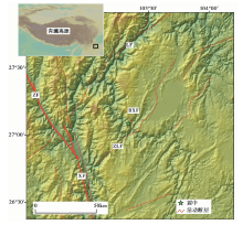
2014年8月3日鲁甸MW6.2地震发生在青藏高原东南缘, 川滇地块以东, 南北地震带中南段(Wang et al., 2010)。这里新生代构造变形强烈, 存在不同走向的活动断层, 曾发生过多次地震(Xu et al., 2003; Zhang et al., 2003; Xu et al., 2015b)。图1展示了该区域的活动断层分布(Xu et al., 2016), 该区域的主控深大断裂为NNW走向的左旋走滑的则木河断裂与小江断裂。受则木河断裂与小江断裂的影响, 东部发育了一系列近平行的走向NE的右旋走滑断裂系, 如莲峰断裂(LF)与昭通-鲁甸断裂(ZLF)。被这些断裂分割的块体内部还发育着一系列小型断裂。本次地震震中位于莲峰断裂与昭通-鲁甸断裂之间, Xu 等(2015b)通过野外地质调查、 余震分布等发现了本次地震产生了1条长度约8km、 NNW向的地表破裂带, 从而证明了本次地震的发震断层为莲峰断裂与昭通-鲁甸断裂之间的NW走向的包谷垴-小河左旋走滑断裂(图1)。该断裂由数条断续展布的断层组成(常祖峰等, 2014; Xu et al., 2015b)。
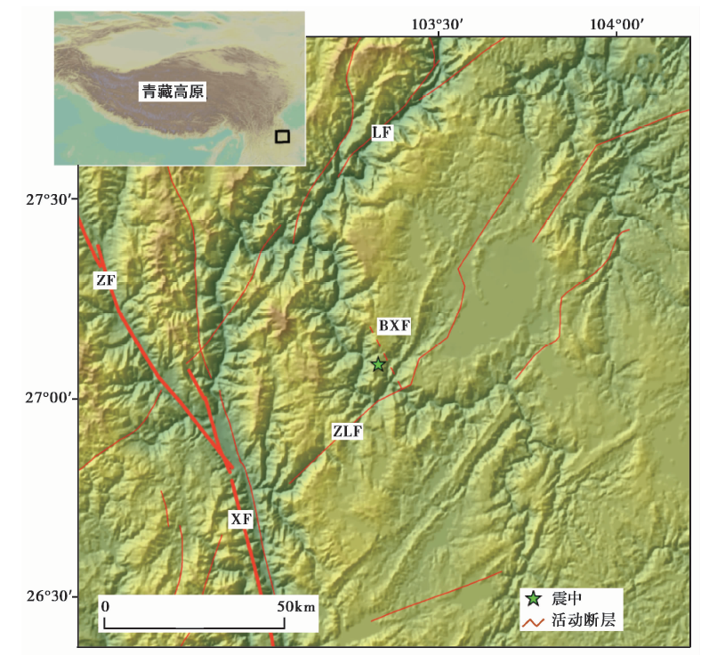 | 图 1 云南鲁甸震区活动断层分布(徐锡伟等, 2016)与震中位置 BXF 包谷垴-小河断裂; ZLF 昭通-鲁甸断裂; LF 莲峰断裂; XF 小江断裂; ZF 则木河断裂Fig. 1 Distribution of the active faults of the Ludian earthquake-affected area(after Xu et al., 2016) and location of the epicenter. |
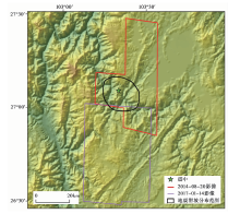
Google Earth公开了全球范围的高分辨率和超高分辨率的遥感影像, 一些地区为多时相遥感影像, 且可以通过三维的方式立体显示, 能够方便研究人员解译滑坡。鲁甸地震已经发生了3a多, Google Earth在震区开放了充足的地震前后的超高分辨率遥感影像。地震区地震前的影像包括3个时段, 分别为2014年1月30日、 2013年3月14日与2011年12月6日, 这3个时段的影像分辨率都是0.5m左右, 覆盖了整个地震区。在地震滑坡密集区内, 震后的影像主要是2014年8月20日, 部分覆盖了图2中的椭圆形滑坡分布区域341km2, 占整个椭圆形区域总面积(357km2)的95.5%。剩下的区域用2017年1月14日的影像来补充(图2)。这些影像保证了同震滑坡受后续降雨或其他因素的影响而改变形态的作用较小, 同震滑坡编录结果中不包括震后降雨或者其他因素触发的新滑坡。且根据震前的影像可以较好地排除掉震前发生的滑坡。
 | 图 2 用于鲁甸地震滑坡解译的震后遥感影像分布Fig. 2 Coverage of post-earthquake satellite images for interpreting of landslides triggered by the Ludian earthquake. |
目前, 建立同震滑坡编目有多种方法(Keefer, 2002; Guzzetti et al., 2012; Xu, 2015), 如野外调查、 基于航片目视解译、 基于卫星影像的目视解译、 结合航片和卫星影像的目视解译、 基于遥感影像的滑坡自动提取等。其中高分辨率卫星影像的目视解译方法具有影像能够覆盖整个地震区、 滑坡编录结果全面详细、 价格相对低廉等优点, 成为了当下开展地震滑坡编录的首选方法。而基于航片的目视解译或者野外考察则往往作为验证基于卫星影像的滑坡解译结果的可靠性、 提高滑坡编录结果质量的可选方法。本研究就利用Google Earth的地震前后的超高分辨率(约0.5m)卫星影像, 采用人工目视解译的方法, 并且与野外考察照片进行对比, 以验证结果的可靠性。由于用于滑坡解译的卫星影像分辨率高达0.5m左右, 因此能够很客观准确地解译同震滑坡。在验证区域内, 野外照片上展示的滑坡与目视解译结果非常一致。采用多边形标识滑坡边界的方式来代表滑坡, 1个封闭的多边形代表1个单体滑坡。由此可得到2014年鲁甸地震触发滑坡编录图。
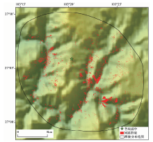
结果表明, 鲁甸地震触发滑坡的密集分布区面积为357km2, 研究区内发生同震滑坡10i559处, 总面积为14.975km2(图3)。这些滑坡中面积最小的为13m2, 最大的为345i292m2。其中, 面积> 100i000m2的滑坡有4个, 面积在10i000m2~100i000m2的滑坡207个, 面积在1i000m2~10i000m2的滑坡有2i654个, 面积在100m2~1i000m2的滑坡有7i083个, 面积< 100m2的滑坡有611个。这些滑坡的总体分布呈椭圆形, 长轴方向为NW-SE方向, 与发震断层走向一致(图3)。整个研究区内滑坡点密度为10i559个/357km2=29.6个/km2; 面积百分比为14.975km2/357km2× 100%=4.2%。
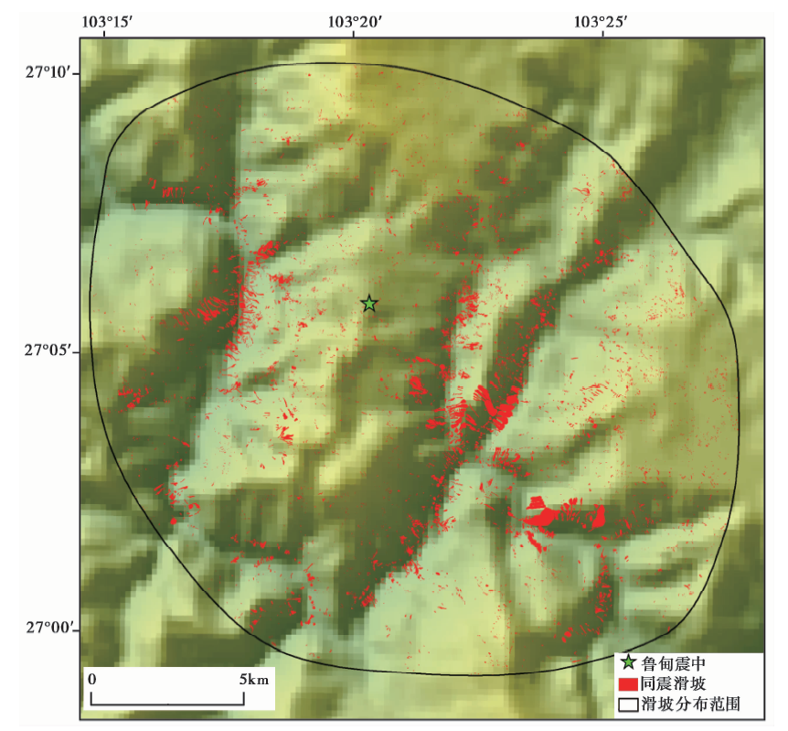 | 图 3 2014鲁甸地震同震滑坡分布Fig. 3 Landslides triggered by the 2014 Ludian earthquake. |
地震滑坡体积可以利用 “ 面积-体积” 幂律方程式获得, 如利用2008汶川地震滑坡体积样本得到的滑坡 “ 面积-体积” 方程式(Xu et al., 2016):
式(1)中, A代表单体滑坡的面积, V代表其体积。为估计鲁甸地震触发滑坡的总体积, 本研究采用此式(1)来分别计算每1个鲁甸地震单体滑坡的体积。然后求得鲁甸地震触发滑坡总体积, 结果为1.24× 10⁸m3, 则滑坡体积密度为1.24× 10⁸m3/357km2=0.35m。
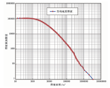
地震触发滑坡往往存在规模与频次的对数关系(Xu et al., 2014a, 2015a), 结果能反映地震滑坡编录图的完整性。图4展示了鲁甸地震滑坡的累加数量N与单体滑坡面积A之间的关系式, 将数据展示在对数坐标轴上。理想状态下两者之间的关系可以表述为下式(2):
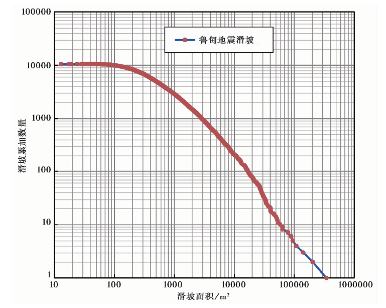 | 图 4 鲁甸地震触发滑坡累加数量与滑坡面积关系曲线Fig. 4 Correlation between the cumulative landslide number and the landslide area related to the Ludian earthquake. |
式(2)中, a和b为系数。由于单次地震同震滑坡编录中难免会遗漏一些中等规模或者小规模地震滑坡, 因此, 在小规模滑坡的部分, 该线段会表现出明显向下弯折的趋势, 这在以往的很多震例(Xu et al., 2014a, b, c, 2015a)中都有体现。该曲线的弯折部分往往表明该尺度的滑坡有比较明显的遗漏。从图4中可以看出本次地震触发滑坡面积开始出现明显弯折的值约200m2, 这表明了面积大于该值的地震滑坡基本不存在遗漏, 小于该面积值的滑坡可能由于在卫星影像上难以识别的原因而有一定的遗漏。
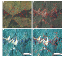
已有的鲁甸地震滑坡编录成果表明这次地震触发了不到2i000处滑坡(许冲等, 2014; Zhou et al., 2016a; Tian et al., 2017)。为定量对比本文结果与以往的研究成果, 选择1个SN长850m, EW宽930m, 中心坐标为27.11° N、 103.31° E的矩形区域对比本文结果与许冲等(2014)结果的差别(图5)。图5a与5b展示了本文的滑坡结果叠加到本研究使用的Google Earth地震前后的卫星影像上。从图中可以看出地震滑坡的区域发生了明显的变化, 植被被破坏, 在这一区域共得到81处同震滑坡。图5c为许冲等(2014)的结果叠加到其所使用的2.5m分辨率的SJ9A全色影像与10m分辨率的SJ9A多光谱影像融合后的分辨率为2.5m的SJ9A影像之上, 这个影像的效果明显差于Google Earth的影像(图5b)。很多中小规模的滑坡难以被识别出来, 结果在这个区域内仅得到了16处滑坡。图5d为2次得到的滑坡编录结果叠加显示, 表明了2次结果的差距来源主要是使用的震后影像分辨率与质量的差别导致的。
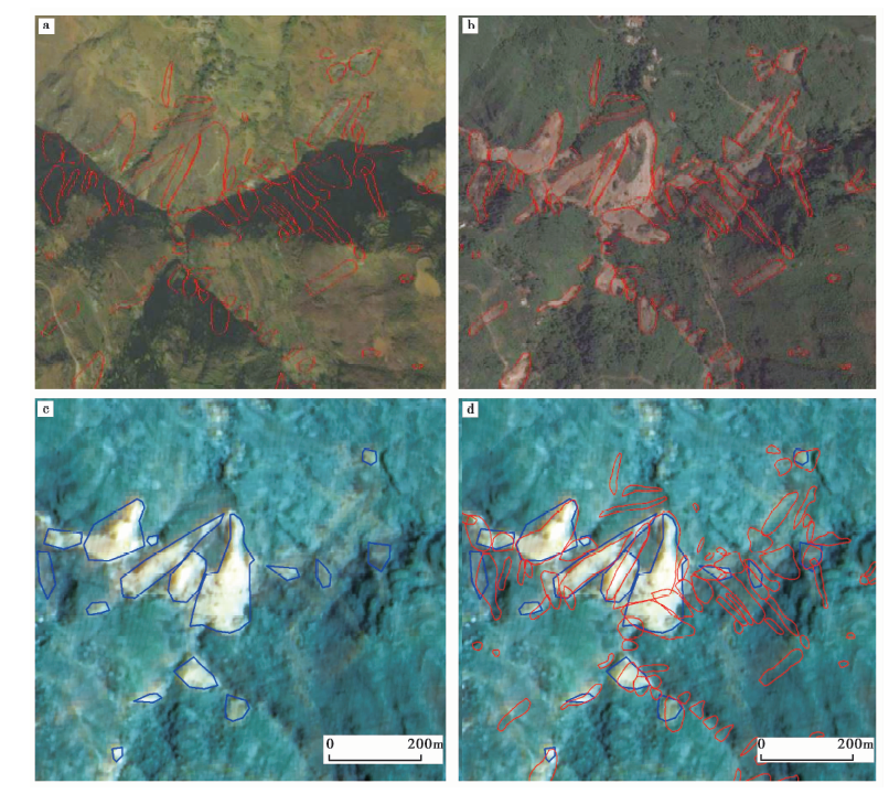 | 图 5 本文成果与以往成果(许冲等, 2014)对比 a 本文解译滑坡与震前Google Earth影像(2011-12-06); b 本文解译滑坡与震后Google Earth影像(2014-08-20); c 许冲等(2014)解译滑坡与其使用的震后SJ9A卫星影像(2014-08-06); d 许冲等(2014)解译滑坡、本文解译滑坡与震后SJ9A卫星影像Fig. 5 Comparisons between coseismic landslides from this study and a previous study(Xu et al., 2014). |
本研究基于Google Earth平台上的超高分辨率(约0.5m)卫星影像, 采用人工目视解译的方法, 建立了1个全新、 详细的2014年8月3日云南MW6.2鲁甸地震同震滑坡编目图。结果表明该地震至少触发10i559处同震滑坡, 总面积为14.975km2, 分布在1个约360km2的椭圆形区域内。与前人的对比结果表明采用的基础影像的分辨率与质量将对同震滑坡结果产生重要的影响。
The authors have declared that no competing interests exist.
| [1] |
|
| [2] |
|
| [3] |
|
| [4] |
|
| [5] |
|
| [6] |
|
| [7] |
|
| [8] |
|
| [9] |
|
| [10] |
|
| [11] |
|
| [12] |
|
| [13] |
|
| [14] |
|
| [15] |
|
| [16] |
|
| [17] |
|
| [18] |
|
| [19] |
|
| [20] |
|
| [21] |
|