


2016年12月8日新疆呼图壁 MS6.2主震震源机制及余震序列定位
[徐志国1, 2  , 梁姗姗
, 梁姗姗3, * , 邹立晔3 , 刘敬光3 ]
, 梁姗姗, 邹立晔|
|


〔作者简介〕 徐志国, 男, 1979年生, 中国科学院大学地球动力学专业在读博士研究生, 高级工程师, 现主要研究方向为地震监测与海啸预警, 电话: 18501150036, E-mail: xuzhg04@sina.com。
北京时间2016年12月8日13时15分03秒, 新疆呼图壁发生了 MS6.2地震。为了更好地了解此次地震的发震机理, 文中利用新疆区域台网波形记录, 采用gCAP(generalized Cut and Paste)方法, 反演得到2016年12月8日新疆呼图壁 MS6.2地震主震的最佳双力偶节面解, 其中节面Ⅰ走向271°、 倾角64°、 滑动角90°; 节面Ⅱ走向91°、 倾角26°、 滑动角90°; 最佳矩心深度为21km, 矩震级 MW5.9。之后采用HypoDD方法, 对468个地震事件进行相对定位, 得到327个重新定位事件, 结果显示地震序列整体沿NWW向分布, 展布长度约35km; 震源深度主要集中在20km以内, 主震和较大余震震源深度较深; 深度剖面显示发震断层面倾向为NNW向, 与北天山山前逆冲推覆构造的总体逆冲方向相反, 结合周围野外地质构造和深地震剖面结果分析, 其发震断层极有可能是位于准噶尔盆地南缘断裂附近的一条隐伏反冲断层。
A strong earthquake with magnitude MS6.2 hit Hutubi, Xinjiang at 13:15: 03 on December 8th, 2016(Beijing Time). In order to better understand its mechanism, we performed centroid moment tensor inversion using the broadband waveform data recorded at stations from the Xinjiang regional seismic network by employing gCAP method. The best double couple solution of the MS6.2 mainshock on December 8th, 2016 estimated from local and near-regional waveforms is strike: 271°, dip: 64°and rake: 90° for nodal plane I, and strike: 91°, dip: 26°and rake: 90°for nodal plane Ⅱ; the centroid depth is about 21km and the moment magnitude( MW)is 5.9. ISO, CLVD and DC, the full moment tensor, of the earthquake accounted for 0.049%, 0.156% and 99.795%, respectively. The share of non-double couple component is merely 0.205%. This indicates that the earthquake is of double-couple fault mode, a typical tectonic earthquake featuring a thrust-type earthquake of squeezing property.The double difference(HypoDD)technique provided good opportunities for a comparative study of spatio-temporal properties and evolution of the aftershock sequences, and the earthquake relocation was done using HypoDD method. 486 aftershocks are relocated accurately and 327 events are obtained, whose residual of the RMS is 0.19, and the standard deviations along the direction of longitude, latitude and depth are 0.57km, 0.6km and 1.07km respectively. The result reveals that the aftershocks sequence is mainly distributed along the southern marginal fault of the Junggar Basin, extending about 35km to the NWW direction as a whole; the focal depths are above 20km for most of earthquakes, while the main shock and the biggest aftershock are deeper than others. The depth profile shows a relatively steep dip angle of the seismogenic fault plane, and the aftershocks dipping northward. Based on the spatial and temporal distribution features of the aftershocks, it is considered that the seismogenic fault plane may be the nodal plane I and the dip angle is about 271°. The structure of the Hutubi earthquake area is extremely complicated. The existing geological structure research results show that the combination zone between the northern Tianshan and the Junggar Basin presents typical intracontinental active tectonic features. There are numerous thrust fold structures, which are characterized by anticlines and reverse faults parallel to the mountains formed during the multi-stage Cenozoic period. The structural deformation shows the deformation characteristics of longitudinal zoning, lateral segmentation and vertical stratification. The ground geological survey and the tectonic interpretation of the seismic data show that the recoil faults are developed near the source area of the Hutubi earthquake, and the recoil faults related to the anticline are all blind thrust faults. The deep reflection seismic profile shows that there are several listric reverse faults dipping southward near the study area, corresponding to the active hidden reverse faults; At the leading edge of the nappe, there are complex fault and fold structures, which, in this area, are the compressional triangular zone, tilted structure and northward bedding backthrust formation. Integrating with geological survey and seismic deep soundings, the seismogenic fault of the MS6.2 earthquake is classified as a typical blind reverse fault with the opposite direction close to the southern marginal fault of the Junggar Basin, which is caused by the fact that the main fault is reversed by a strong push to the front during the process of thrust slip. Moreover, the Manas earthquake in 1906 also occurred near the southern marginal fault in Junggar, and the seismogenic mechanism was a blind fault. This suggests that there are some hidden thrust fault systems in the piedmont area of the northern Tianshan Mountains. These faults are controlled by active faults in the deep and contain multiple sets of active faults.
中国地震台网中心正式测定: 北京时间2016年12月08日13时15分03秒在新疆昌吉回族自治州呼图壁县(43.83° N, 86.35° E)发生MS6.2地震, 震源深度6km。截至2016年12月13日12时00分, 共记录到余震1i438个, 其中4.0~4.9级地震3个, 3.0~3.9级地震10个。
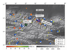
此次地震位于北天山造山带与准噶尔盆地的衔接地带, 该地区历史上地震活动性较强、 频度较高, 1906年在此区域曾发生玛纳斯7.7级地震(新疆维吾尔自治区地震局, 1985)。 发生在此区域的地震均为浅源地震, 震源深度多集中在0~40km。研究区以逆断层为主, 地震主破裂面基本为NWW向或近EW向(龙海英等, 2008)(图1), 且此区域是构造活动十分强烈的地带, 褶皱断裂等构造现象十分发育; 从南向北断裂-褶皱带的形成时代逐渐变新(陈正乐等, 2009)。
 | 图1 新疆呼图壁MS6.2地震主震邻区地质构造图及历史地震震源机制(引自全球矩心矩张量(GCMT)项目)和历史地震(引自国际地震中心(ISC)报告) 图中1906年玛纳斯7.7级地震震中引自新疆维吾尔自治区地震局, 1985Fig. 1 The geotectonic map of the MS6.2 Hutubi, Xinjiang earthquake region, with the historical mechanism solutions from GCMT, event locations from ISC bulletin. |
中国地震局地质研究所(2016)给出的区域地震构造图显示, 此次呼图壁MS6.2地震震中位于准噶尔盆地南缘断裂与齐古断裂之间。准噶尔南缘断裂是分隔天山山体和乌鲁木齐山前坳陷的一条重要的边界断裂(张培震等, 1994), 其总体走向为280° , 断面S倾, 倾角60° ~80° , 为逆冲断裂(孙小旭等, 2016)。齐古断裂走向近EW向, 断面同样为S倾, 倾角为60° 左右, 为逆冲断裂(陈建波, 2008)。这2条断裂均在晚更新世有过活动。
由于震源机制可以直观地反映地震破裂的几何特征和运动学特征(赵小艳等, 2012; 梁姗姗等, 2018), 且主震的震源深度和余震的时空分布特征可为认识断层的活动规律提供重要的地震学基础(Lei et al., 2012, 2014; 张广伟等, 2014a)。杨智娴等(2003)曾指出双差定位可以更好地约束震源深度, 而震源深度是研究地震成因与机制的一个非常重要的因素。因此, 本文首先采用gCAP方法, 对主震进行全矩张量反演, 获得主震的质心深度和震源机制解; 之后采用HypoDD相对定位方法, 对主震及余震序列进行精定位, 获得地震序列重定位特征; 最后根据这些震源机制和定位结果, 结合区域构造, 深入地讨论此次地震的发震机理。
本次新疆呼图壁MS6.2地震是发生在新疆维吾尔自治区境内地震监测能力较好的北天山地区, 新疆地震台网已完成了研究区(43.5° ~44.1° N, 86.0° ~86.7° E)内的震相报告编辑, 区域台站也已记录了较好的地震波形, 这些数据为本研究中震源机制反演和地震定位的顺利进行奠定了良好基础。本研究所使用的台站见图2a。主震震源机制反演所用的波形数据来自国家测震台站和新疆区域测震台站。根据波形质量和台站方位角分布, 筛选出11个台站的波形资料(图2a)。
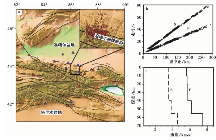 | 图 2 a 地震台站及本次地震序列初始地震震中分布; b P波和S波观测走时曲线; c 本研究所使用的速度模型 蓝色三角形代表本研究所使用的台站, 红色三角形代表震源机制反演所用的台站Fig. 2 Map of the seismic stations and the map of preliminary epicenters of this earthquake sequence(a), P- and S-wave observed travel-time curves(b), and the velocity model used in this study(c). |
地震序列重定位时所用的初始震源位置和震相数据来自新疆台网震相观测报告, 尽管2016年12月8日— 2017年5月15日发生了上千次地震, 但震相报告中所含有的且能够较好定位的地震事件共468个(台站记录个数≥ 4, 图2a)。为了保证定位质量, 在进行定位前, 选择震中距≤ 300km且绝对走时残差≤ 2s的台站所记录的震相数据(图2b)。
1.2.1 震源机制方法
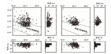
本研究采用gCAP方法(generalized Cut and Paste)(Zhu et al., 2013)反演主震的震源机制, 此方法适用于中等强度地震。该方法将体波的Pnl段与后续的面波段 “ 切开” , 分别进行波形拟合, 在拟合过程中通过波形互相关的方法在2个波形段中各自引入适当的延时来弥补地壳模型的缺陷, 从而使拟合更加稳定(张广伟等, 2014b)。相比传统的CAP方法(Cut and Paste)(Zhu et al., 1996), gCAP可以反演地震矩张量, 即包含各向同性和偏张量部分(张广伟等, 2015)。格林函数采用频率-波数方法(F-K)(Zhu et al., 2002)获得; 该方法分别对频率和波数进行积分, 采用传播矩阵计算地震的全波长位移, 得到各种频率下的体波和面波波形, 应用于震源参数的反演(谢祖军等, 2012)。本研究反演震源机制时, Pnl和面波的滤波范围分别为0.05~0.2Hz和0.02~0.08Hz, 走向、 倾角和滑动角的搜索间隔均为10° , 深度的搜索间隔为1km; 计算格林函数时, 设采样间隔为0.1s, 采样点1i024个。
1.2.2 定位方法
本研究采用HypoDD方法(Waldhauser et al., 2000)对主震及余震序列进行重定位。此方法是适用于地震丛集的一种相对定位方法, 其最优化判据不是使到时残差的均方根达到极小值, 而是使每个事件对的2个到时残差之差达到极小值。此时这2个到时残差主要是由事件对间的位置变化所引起, 对速度模型的依赖性相对较小(赵博等, 2013; 王健等, 2016; 梁姗姗等, 2017)。本研究进行重新定位时, 将事件对间的最大距离设为10km, 双差数据最小连接数为8, P波和S波的权重分别设为1和0.5。
反演震源机制和地震重定位所使用的一维速度模型均参考了人工勘探和接收函数的综合结果(李秋生等, 2001; 刘文学等, 2014), 设泊松比为1.73(图2c)。
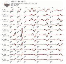
采用gCAP方法反演得到2016年12月8日新疆呼图壁MS6.2地震主震的全矩张量解, 其节面Ⅰ 走向271° 、 倾角64° 、 滑动角90° ; 节面Ⅱ 走向91° 、 倾角26° 、 滑动角90° 。通过不同深度的震源机制反演, 得到主震的最佳质心深度为21km。从图3可以看出, 震源机制解在不同深度上变化不大, 均显示为逆冲型, 证明了所得震源机制的可靠性。图4为21km深度上主震的震源机制解(下半球投影)以及理论和实际波形拟合图。由图4可以看出, 在深度为21km时, 参与反演的11个台站所记录的54个波段中, 理论波形与实际波形相关系数> 0.7的波段数有45个, 占总数的83.3%, 可见波形拟合较好, 震源参数较为可信。此次地震全矩张量ISO、 CLVD和DC 3部分所占的比例分别为0.049%、 0.156%和99.795%, 非双力偶成分仅占0.205%, 这说明该次地震为双力偶型的破裂模式, 是典型的构造地震, 表现为挤压性质的逆冲型地震。将所得到的地震震源机制解分别与全球矩心矩张量目(GCMT)和美国地质调查局(USGS)及中国地震局地球物理研究所(IGP)得到的结果进行对比(表1)。为了对比不同机构的反演结果, 采用Kagan(1991, 2007)定义的不同震源机制间的最小旋转角(Kagan角)来衡量反演结果间的差别。选取本研究得到的震源机制作为参考解, 计算其与GCMT、 USGS和IGP 3家机构震源机制解之间的Kagan角。
 | 图3 2016年12月8日MS6.2新疆呼图壁主震不同深度上地震全矩张量解及其反演方差Fig. 3 Full moment tensor solutions and inversion variances in different depths of the December 8th, 2016 Hutubi, Xinjiang, MS6.2 mainshock. |
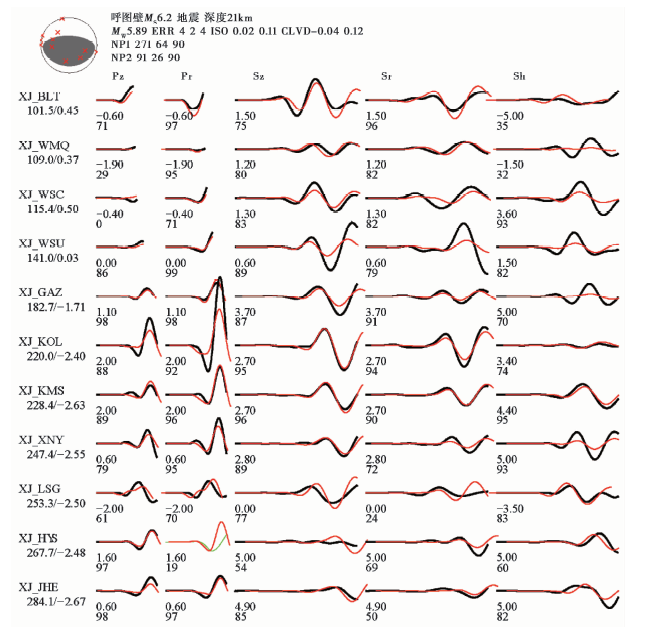 | 图4 2016年12月8日呼图壁MS6.2地震全矩张量解及理论(红色)和实际(黑色或绿色)波形对比图 拟合较好的波形用黑色表示, 拟合较差的波形用绿色表示。波形下方的数字表示理论波形相对实际波形的相对移动时间和二者的相关系数; 左侧大写字母表示台站名, 其下方数字为震中距(km)和相对偏移时间Fig. 4 Full moment tensor solutions of the December 8th, 2016 Hutubi, Xinjiang, MS6.2 earthquake and the comparison of the synthetic(red)and observed(black or green)recordings. |
| 表1 不同研究机构给出的新疆呼图壁MS6.2地震震源参数 Table1 Focal parameters of the MS6.2 earthquake in Hutubi, Xinjiang from different institutions |
由表1可看出Kagan角为18.3° ~8.1° , 均< 20° , 变化范围不大。分析结果总体表明, 本文的震源机制结果和GCMT、 USGS和IGP的结果基本一致, 但仍存在一定偏差, 可能与反演过程中台站资料的选取、 网格搜索步长或速度模型的不同有一定关系, 但这些偏差是完全可以接受的, 同时也表明本研究所得的震源机制具有可靠性。
为了进一步探讨此次呼图壁地震的发震断裂, 采用HypoDD定位方法对2016年12月8日新疆呼图壁MS6.2地震序列进行相对定位, 共获得327个地震事件的重定位结果。其平均均方根残差为0.19, 沿经度、 纬度及深度上的平均标准误差分别为0.57km、 0.6km和1.07km。重定位前后地震事件数量的差异可能与双差定位方法具有定位结果更加集中、 呈簇状或条带状等分布的特点有关, 另外, 本研究区域的台站分布较不均匀, 这可能也是造成部分地震事件丢失的原因。为了清楚地了解重定位的效果, 我们对比了重定位前后震源位置的变化情况。重定位前地震在平面上的分布较零散, 而且震源深度主要集中在6~7km和10~11km 2个范围内(图5a), 这样的定位结果不能很好地分辨优势发震断层面。重定位后可以看出, 地震序列在平面上沿NWW向呈块状分布, 震源深度主要分布在0~20km, 且主震震源深度较深(图5b)。本次呼图壁MS6.2主震重定位震中位于43.78° N, 86.39° E, 深度16.3km, 其沿经度、 纬度和深度的误差分别为0.71km、 0.48km和1km。重定位主震震源深度由新疆台网震相报告的15km改进到16.3km, 这一结果与王椿镛等(2001)使用统计学方法得到的此区域M≥ 3.7地震的优势震源深度(约20km)及美国地质调查局使用P波和S波走时所确定的初始震源深度17.6km均较为接近; 并且, 罗艳等(2013)曾指出, 对于6.0级以上的强震, USGS可以较好地测定震源深度。以上都可以说明, 所获得的相对定位结果较为可靠。
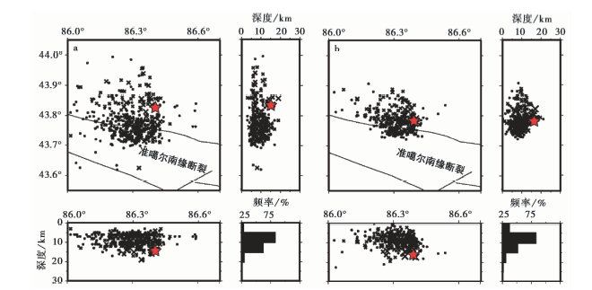 | 图5 重定位前(a)和重定位后(b)平面、 侧面和深度分布图Fig. 5 Horizontal and vertical distributions before(a)and after(b)the relocation of the earthquake sequence. |
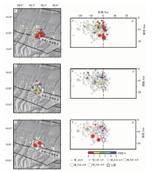
按照不同时间段展示主震后15h内余震的分布情况, 以便更好地展现余震的时空变化特征和扩展模式(图6)。第一阶段为主震后0~5h, 余震主要发生在主震周围, 分布密集, 沿SW向扩展, 有少量余震沿NW向扩展, 二者呈明显的共轭分布特征, 余震主要分布在主震上方, 震源深度由深变浅, 倾角较陡; 第二阶段为主震发生后6~10h, 该时间段相对早期余震活动减弱, 但余震展布范围增大, 沿主震SW和NW 2个方向继续扩展; 第三阶段为主震后11~15h, 此阶段余震数量虽已经明显减少, 但沿NW方向仍发生了2次较大震级的余震, 且这2次余震的震源深度相对较深。总的来说, 主震后15h内, 各时段均有余震分布, 序列早期活动主要分布在主震周围, 有2个较明显的优势分布方向, 总体呈NW向分布, 在主震附近也有近SW方向的扩展特征, 余震震源深度由深变浅, 倾角较陡, 符合逆冲型地震的余震分布特征。余震序列活动详细的时空分布特征与该地震的震源破裂方式有关, 需要结合地震破裂时空分布的细节进行深入探讨。
 | 图 6 主震后15h内不同时间段地震平面及深度剖面图 AA’为沿断裂带走向的纵剖面, 不同颜色代表主震后每5h内的相对时间, 无颜色代表所有重定位地震结果Fig. 6 Cross-sections along the horizontal and vertical direction, showing the distribution of the earthquake sequence during the 3 different 5-hour periods after the mainshock. AA’ is the vertical cross section along the fault. The relocated events during the interested 5 hours are marked in red while others in white. |
重定位后, 地震序列在平面上主要分布于准噶尔南缘断裂的北侧, 形成这一现象可能是因为发震断裂为逆冲断裂, 因此将地震投影到平面后震中就位于断裂的单侧, 这在2015年新疆皮山MS6.5地震序列分布中也有相同的体现(张广伟等, 2015)。为了详细展示发震断层面的结构特征, 我们给出3条剖面, 其中1条为沿断裂带走向的NWW向剖面, 另外2条为横切剖面(图7)。将距这2条横切剖面2km范围内的所有余震序列投影在其上, 2条剖面间距约10km。沿断裂带走向的剖面显示(图7a), 余震展布长约35km, 宽约20km, 总体向主震的NW方向扩展, 余震主要在主震上方呈倒三角状分布, 震源深度沿主震NW向逐渐变浅, 主要集中在0~20km, 较大余震位于相对较深处。穿过主震的剖面BB'展示出余震向NNE向倾斜, 初始破裂点位于较深部, 以初始破裂点为中心向主震上方扩散。剖面CC'同样展示出余震向NNE倾斜的趋势。2条纵剖面均显示出倾角较陡的发震断层面; 结合之前得到的余震时空分布特征, 认为发震断层面可能为节面Ⅰ , 走向约271° 。
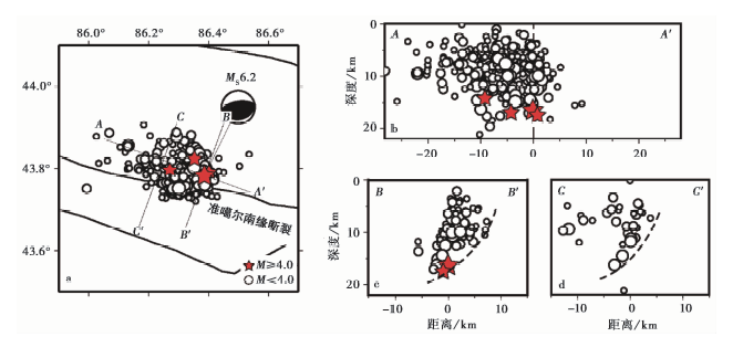 | 图 7 重定位地震事件剖面图 a AA’为沿断裂带方向纵剖面, BB’为横穿主震但垂直于断层的纵剖面, CC’与BB’类似, 但在主震的西侧; b所有重定位地震事件的投影; c、 d距离剖面2km范围内地震事件的投影。剖面纵横向比例为1︰1, 震源机制为本研究所得震源机制解, 黑色虚线代表可能的发震断层Fig. 7 Cross sections of the relocated earthquakes. |
本研究采用gCAP(generalized Cut and Paste)震源机制反演方法获得了2016年12月8日新疆呼图壁MS6.2地震的震源机制。 结果显示, 此次地震为逆冲型事件, 不同深度震源机制反演得到的主震最佳质心深度为21km, 矩震级MW5.9; 采用HypoDD相对定位方法获得此次地震序列重定位结果, 结果表明, 主震震源深度为16.3km。
已有的地质构造研究结果表明, 北天山与准噶尔盆地之间的结合带上具有典型的大陆内部活动构造特征, 存在着众多的逆冲褶皱构造, 表现为多排新生代时期形成的平行山体的背斜和逆断裂, 其构造变形明显表现出纵向分带、 横向分段和垂向分层的变形特点(汪新伟等, 2005; 李树新等, 2008)。准噶尔南缘自第四纪晚期以来, 地表活动明显减弱(宋和平, 2006)。陈书平等(2007)通过地面地质调查和地震资料的构造解释, 认为呼图壁地震震源区附近发育着反冲断层, 且与背斜有关的反冲断层皆表现为盲冲断层。刘保金等(2007)利用深地震反射剖面的方法, 揭示出研究区域附近发育了多条S倾的铲型逆断裂, 并且对应着相应的活动隐伏逆断裂; 且在推覆体前缘有着复杂的断裂和褶皱构造, 在本区表现为挤压三角区、 掀斜构造和N倾的顺层反冲断层组。杨庚等(2012)所完成的地质剖面同样也显示出震源区域准噶尔南缘断裂控制的活动背斜和断裂构造非常发育, 震中附近的活动逆断裂多出现在活动背斜北翼和其核部附近。重定位震源深度剖面显示余震发震断层向N倾, 其原因可能是主断裂逆冲滑动中受到前侧很强的推挤作用而反向逆冲, 表现为断裂构造向N倾的特点, 其与此区域整体断层的倾向相反。这是地质学逆冲推覆构造中比较常见的一种构造模式(朱志澄等, 1999), 反映呼图壁震区的构造极其复杂。
结合余震空间分布特征、 主震震源机制及研究区域地质构造等结果判断, 此次呼图壁MS6.2地震的发震构造很有可能是位于准噶尔盆地南缘断裂附近的一条隐伏反冲断层, 此次地震与2013年芦山M7.0地震(房立华等, 2013)以及2015年新疆皮山地震(张广伟等, 2016)类似, 均发生在隐伏断裂带上, 但最终还需要结合人工地震测深、 野外地质考察等结果进行确认。此外, 1906年的玛纳斯地震同样发生在准噶尔南缘断裂附近, 发震构造为一条盲断层(张培震等, 1994)(图1), 说明北天山山前区域存在一些隐伏逆冲断层系统, 这些断层在深部受活动断裂控制, 并包含多组活动断裂。呼图壁MS6.2地震震源区复杂的区域地质构造背景和地震构造条件, 仅通过对余震序列时空分布特征和主震震源机制, 无法在如此小的尺度范围内分辨出是否有多条断裂破裂, 同时, 地震断层间相互作用的力学机制还有待进一步的深入研究。
致谢 Zhu L P提供了gCAP程序, Waldhauser F提供了双差定位程序; 中国地震局地壳应力研究所雷建设研究员、 任俊杰研究员、 程佳副研究员和张广伟副研究员为本文的撰写提供了帮助; 审稿人对本文提出了宝贵的修改意见。 在此一并表示感谢!
The authors have declared that no competing interests exist.
| [1] |
|
| [2] |
|
| [3] |
|
| [4] |
|
| [5] |
|
| [6] |
|
| [7] |
|
| [8] |
|
| [9] |
|
| [10] |
|
| [11] |
|
| [12] |
|
| [13] |
|
| [14] |
|
| [15] |
|
| [16] |
|
| [17] |
|
| [18] |
|
| [19] |
|
| [20] |
|
| [21] |
|
| [22] |
|
| [23] |
|
| [24] |
|
| [25] |
|
| [26] |
|
| [27] |
|
| [28] |
|
| [29] |
|
| [30] |
|
| [31] |
|
| [32] |
|
| [33] |
|
| [34] |
|
| [35] |
|
| [36] |
|
| [37] |
|
| [38] |
|
| [39] |
|
| [40] |
|
| [41] |
|
| [42] |
|
| [43] |
|
| [44] |
|
| [45] |
|
| [46] |
|
| [47] |
|
| [48] |
|
| [49] |
|
| [50] |
|
| [51] |
|
| [52] |
|
| [53] |
|
| [54] |
|
| [55] |
|
| [56] |
|
| [57] |
|
| [58] |
|
| [59] |
|
| [60] |
|
| [61] |
|
| [62] |
|
| [63] |
|
| [64] |
|
| [65] |
|
| [66] |
|