祁连山东段石羊河流域河流纵剖面及其构造意义
[高效东1  , 谢虹
, 谢虹1, * , 袁道阳1 , 苏琦2 , 邵延秀1 ]
, 谢虹, 袁道阳|
|


〔作者简介〕 高效东, 男, 1994年生, 中国地震局兰州地震研究所活动构造与构造地貌学专业在读硕士研究生, 主要研究方向为新活动构造与构造地貌, E-mail: norman_gaoxd@163.com。
石羊河流域位于祁连山东段, 其河流体系记录了最新的构造信息和构造活动。提取石羊河流域的地貌信息, 有助于揭示祁连山东段石羊河流域地貌对构造活动的响应, 及系统探讨该区地貌发育特征及其所蕴含的构造意义。文中基于GIS空间分析技术, 利用数字高程模型(DEM)、 Matlab脚本提取了石羊河流域7条河流的纵剖面, 并利用基岩河道水力侵蚀模型对其进行分析, 获得了7条河流的陡峭系数、 平均侵蚀量、 凹曲度、 裂点分布、 高程、 距河流出水口距离和流域面积等地貌信息。结果表明, 石羊河流域的各条支流至少存在1个主裂点, 裂点上、 下河段具有不同的陡峭度( ks)与凹曲度( θ), 说明河流纵剖面裂点的上、 下河段具有不同的发育趋势。对河流纵剖面、 裂点分布及岩性进行综合分析, 结果表明, 古浪河、 金塔河、 杂木河、 西营河、 东大河和西大河都具有 “坡折式”裂点, 处于瞬时状态。祁连山东段河流地貌演化主要与构造活动相关。利用本区晚第四纪活动断裂相关裂点上游河道的凹曲度指标拟合出整条河流, 得到石羊河流域的平均侵蚀量约488m, 发源于古浪推覆体的6条支流的平均侵蚀量为508.5m。进一步计算研究区河网归一化的河流陡峭系数( ksn)并得到其空间分布, 结合河流纵剖面和裂点分析结果对祁连山东段石羊河流域的构造特征进行了综合分析, ksn的结果显示下游段陡峭系数<60, 中游明显大于下游。同时, 位于构造结处的古浪推覆体其 ksn 值呈现高值, 表明该区第四纪以来经历了明显的构造抬升过程。文中结果表明石羊河流域地貌演变处于非均衡状态, 构造变形是祁连山东段地貌演化的主要影响因素, 控制着该区现今的地貌发育及演化历史。
The river system is very sensitive to landscape fluctuations and the pattern of drainage contains the past and present tectonic information and can record the latest even tiny change along the orogenic belt system. Therefore, fluvial geomorphology is always used to describe the shapes of river channels and recognize the different segments of active faults. Qualitative and quantitative geomorphic analyses can provide useful information on detecting active tectonic features and the influence of landscape change and evolution. Quantitative analysis such as analysis of river longitudinal profile and geomorphic indices can help researchers evaluate the relative level of tectonic activity and characterize the geomorphic features of landscape quantitatively.
Our study focuses on the geomorphic analysis of Shiyanghe River Basin which is located in the eastern part of Qilianshan Mountains. The tectonic deformation is very strong since late Cenozoic, and Quaternary active thrust faults, strike-slip faults and active folds are distributed all over the region, indicating that the whole region is suffering from crustal shortening and sinistral shear. In this region, the latest tectonic deformation and tectonic activities have been recorded by its fluvial system.
Based on GIS spatial analysis technology, the longitudinal profiles of seven tributaries(including Gulanghe River, Huangyanghe River, Jintahe River, Zamuhe River, Xiyinghe River, Dongdahe River and Xidahe River)in the Shiyanghe River Basin are extracted by using digital elevation models(DEM)and Matlab script. In channel longitudinal profiles, most tributaries in Shiyanghe River Basin exhibit an increased channel gradient in their midstream and downstream area. This pattern is consistent with the models of transient channel profile which suggests an increase in rock uplift rate or base level fall. The longitudinal profiles of seven tributaries are analyzed synthetically by using the method of bedrock channel erosion model, and the concavity( θ), steepness index( ksn), as well as the knickpoints information(including distribution, elevation, distance from mouth and drainage area)of seven tributaries are obtained. The result shows that each of the tributaries in the Shiyanghe River Basin at least has one major knickpoint. The comprehensive study of the longitudinal profiles, knickpoints and the lithology of the river basin show that the Gulanghe River, Jintahe River, Zamuhe River, Xiyinghe River, Dongdahe River and Xidahe River all have ‘slope-break’ knickpoints, which suggest that they are in a transient state. The knickpoints represent a transient response to the dynamic surface uplift since late Cenozoic. Therefore, we can conclude that the evolution of fluvial geomorphology in eastern Qilian Mountains is mainly related to tectonic activities. Channel segments upstream of knickpoints exhibit lower concavities(mean θ is 0.458±0.053)and higher channel steepness indices(mean ksn is 129.09±1.82). In contrast, lower channel segments are more complanate(mean ksn is 68.162±0.821)and exhibit a higher concavity(mean θ is 0.831±0.147). The distribution of concavity is related to the erosion rate, thence, we can infer that the higher value of concavity in downstream area indicates the higher erosion rate. Because the different steepness index( ks)and the concavity( θ)below and above the reach of knickpoints indicate that they have different development trends in different channel segments, and the distribution of knickpoints represent the evolution process of the longitudinal section of the tributaries. Using the concavity value of the knickpoint, each lower reach longitudinal profile of tributary is fitted. According to the fitted result, the calculated approximate average erosion volume of the Shiyanghe River Basin is 488m since it formed, and the average erosion volume of the six tributaries, which originated in Gulang nappe, is 508.5m. The total amount of erosion is positively correlated with rock uplift when a river is in transient state. Thence, it concludes that the Gulang nappe has experienced a strong uplift. Furthermore, we obtained the spatial distribution of ksn values of the whole fluvial system in the Shiyanghe River Basin from calculating and interpolating the ksn values, and combined the geomorphic parameters results to analyze the tectonic significance of the Shiyanghe River Basin synthetically. The spatial distribution of ksn values of the Shiyanghe River Basin represent the accommodation of geomorphic landscape to the tectonic force and the manner of channels responding to tectonic forces. In this study, most of the channel gradients obtained from midstream are higher than upstream and downstream and ksn values in downstream reaches is less than 60m0.9, the high ksn values are in the Gulang nappe, reaching over 1 400m0.9, which indicates that the Gulang nappe has experienced uplift since the Quaternary. Therefore, we conclude that the regional difference of the ksn is mainly controlled by the uplift rate of bedrocks.
Based on the comprehensive analysis of geomorphic parameters and tectonic background, we conclude that the geomorphic evolution of the Shiyanghe River Basin is in a non-equilibrium state, and the tectonic deformation is the main factor affecting the geomorphic evolution of the eastern Qilianshan Mountains and controlling the present tectonic pattern, geomorphic development and evolution history of the study area.
According to the river longitudinal profiles and modeling analysis, this study indicates that the quantitative geomorphic analyses can provide useful and effective information on detecting active tectonic features and the influence of landscape change and evolution, and the geomorphic indices are useful and appropriate tools to analyze the coupling of tectonic and geomorphy.
中新世以来, 印度板块和欧亚板块持续挤压碰撞, 逐渐形成了青藏高原。青藏高原的形成不仅控制了欧亚板块内部晚新生代以来的构造变形, 还对周边地貌格局和环境演化产生了极大影响(Molnar et al., 1975; 李吉均等, 2001; Tapponnier et al., 2001)。12~10MaiBP, 青藏高原以逆冲断裂、 褶皱变形、 左旋走滑及其伴随的山脉隆起和盆地消亡的方式向NE扩展, 祁连山开始隆升(张培震等, 2006; 郑德文等, 2013)。晚第四纪以来, 在阿尔金断裂与祁连北缘断裂的共同作用下, 祁连山地区经受了显著的地壳缩短与左旋剪切作用, 逆冲断裂、 走滑断裂以及活动褶皱广泛发育, 并形成了一个巨大的挤压阶区(袁道阳等, 2004; Zheng et al., 2013; 郑文俊等, 2016)。而在祁连山东段, 广义海原断裂与祁连山北缘断裂在石羊河流域上游近平行展布, 记录了祁连山北缘断裂自新生代以来的构造活动(刘百篪等, 2008)。石羊河发源于祁连山东段, 其流域上游支流众多, 跨越了祁连山及河西走廊。祁连山东段山前发育的多条河流记录了该区丰富的构造信息。因此, 石羊河流域为研究河流对青藏高原前陆传播所引起的地表隆升响应提供了理想的场所。
河流系统作为陆地上重要的地貌单元, 在地表侵蚀、 物质运输和沉积物积累过程中起着非常重要的作用, 也是改变地貌的最重要的因素之一(胡小飞等, 2014; 王一舟等, 2016)。此外, 河流对外部因素, 如构造和气候的变化非常敏感, 能记录沿造山带系统最新的微小变化(Shi et al., 2018)。因此, 河流体系成为记载新构造运动和地貌演化过程的理想载体(Kirby et al., 2003)。前人的研究指出岩石抬升速率与河道侵蚀速率正相关, 岩石抬升速率越高, 河道侵蚀越快(Shi et al., 2018)。岩石隆起导致河流侵蚀加快, 并使沿河流系统纵向剖面的河道梯度变化(胡小飞等, 2014; Shi et al., 2018)。河流纵剖面的形态是多种地表过程的函数, 若其倾向于向上凸形, 则说明河流处于稳定的平衡状态; 如果平衡河流系统被气候、 构造活动或岩性扰动所破坏, 则可能出现凹形剖面。河流纵剖面的几何特征是识别基岩隆起空间模式的有效手段, 其不连续性可能与坡降的变化、 不同的岩性或构造活动的影响有关(Whipple et al., 1999; Snyder et al., 2000)。Gardner(1983)在均质基岩上进行了一系列试验, 研究了裂点和纵剖面的演化规律。Higgins(1984)对基准面连续下降时形成的裂点进行分析, 认为裂点演化有3种模型, 即平行后退、 置换和倾斜。Snyder等(2000)和Kirby等(2003)开发了提取河道纵剖面和分析相关地貌参数的Matlab脚本, 为系统分析河道纵剖面提供了有效工具。
前人对祁连山地区的地貌发育与演化研究主要集中在祁连山西段(刘兴旺等, 2012; 张会平等, 2012; 王一舟等, 2013; 王一舟, 2014; Wang et al., 2014; Zhang et al., 2014; 苏琦等, 2016; 杨海波, 2016; 杨海波等, 2017), 对于东段的地貌研究主要集中于盆岭构造(苏琦等, 2017)和河流阶地的构造演化分析(潘保田等, 2000; 高红山等, 2005; 胡小飞等, 2013; Pan et al., 2013; 苏琦等, 2017); 胡小飞等(2013)对祁连山东段河流阶地的形成年代进行了限定, 并分析了形成年代与气候的关系。然而以往对祁连山东段构造地貌以及其所反映的构造活动没有做深入的研究。
在本研究中, 我们利用精度为1角秒的 SRTM(30m)数字高程模型提取了石羊河流域的河流纵剖面, 分析ksn 值及岩性变化, 确定了与新构造活动相关的裂点, 并依据裂点和河流侵蚀模型对纵剖面进行了拟合, 估算河流的侵蚀总量。结合河流陡峭系数的空间分布, 分析并揭示了祁连山东段石羊河流域地貌对构造活动的响应, 并系统探讨该区地貌发育特征及其所蕴含的构造意义。
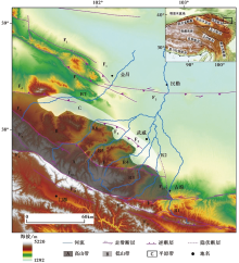
石羊河流域位于祁连山东段。流域上游位于祁连山内部, 地貌起伏较大, 流域下游则为河西走廊冲洪积平原区, 起伏度极小。Pan等(2013)将研究区划分为高山带(海拔3i200~4i500m)、 低山带(海拔2i200~3i100m)和平原带(海拔< 1i800m)3个大单元(图1)。高山带主要分布奥陶系砂岩和变质砂岩, 局部少量分布志留系碳酸盐岩、 砂岩, 石炭系砂岩以及二叠系玄武岩夹砂泥岩; 低山带以二叠-三叠系砂岩、 砾岩以及砂砾岩为主, 另含有少量寒武系砂、 泥岩夹花岗岩脉; 走廊平原带则主要以更新统、 全新统近代河流冲洪积物为主(Pan et al., 2013)。受祁连山北缘断裂和海原断裂等构造活动的控制和影响, 区域地貌的演化受到多期构造活动的控制, 发育了由多条挤压逆冲断裂组成的古浪推覆体构造(袁道阳等, 2004; 郑文俊等, 2016), 形成了地貌起伏大并向N逐渐降低的基本地貌框架(苏琦等, 2017)。
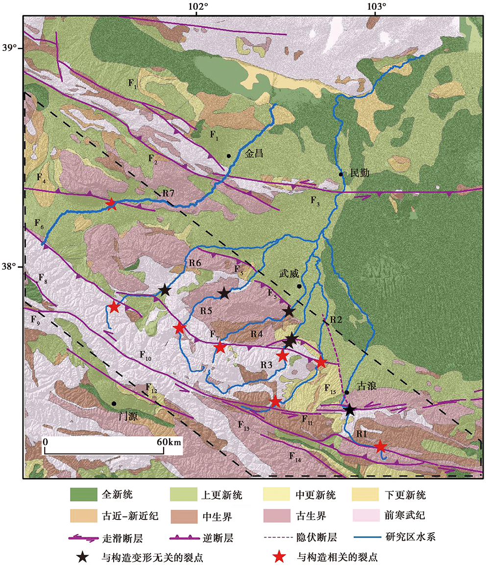
 | 图 1 祁连山地区地质地貌简图F1龙首山北缘断裂; F2龙首山南缘断裂; F3河西堡-四道山断裂; F4民乐-永昌断裂; F5武威盆地南缘断裂; F6民乐-大马营断裂; F7皇城-双塔断裂; F8肃南-祁连断裂(俄堡段); F9托勒山北缘断裂; F10冷龙岭断裂; F11天桥沟-黄羊川断裂; F12门源断裂; F13金强河-毛毛山-老虎山断裂; F14玛雅雪山断裂; F15武威-天祝隐伏断裂; R1 古浪河; R2 黄羊河; R3 杂木河; R4 金塔河; R5 西营河; R6 东大河; R7 西大河Fig. 1 Geomorphologic map of eastern Qilian Mountains. |
研究区内发育了一系列河流, 由西向东依次为: 古浪河(R1)、 黄羊河(R2)、 杂木河(R3)、 金塔河(R4)、 西营河(R5)、 东大河(R6)和西大河(R7); 除西大河外, 其他河流均发育于古浪推覆体之上, 向N流经不同的地质地貌和构造单元; 其中西大河经金昌流入腾格里沙漠, 其余河流于武威市北部汇聚, 干流即为石羊河, 向N流入腾格里沙漠。
研究区发育了龙首山北缘断裂(F1)、 龙首山南缘断裂(F2)、 河西堡-四道山断裂(F3)、 民乐-永昌断裂(F4)、 武威盆地南缘断裂(F5)、 民乐-大马营断裂(F6)、 皇城-双塔断裂(F7)、 肃南-祁连断裂(俄堡段)(F8)、 托勒山北缘断裂(F9)、 冷龙岭断裂(F10)、 天桥沟-黄羊川断裂(F11)、 门源断裂(F12)、 金强河-毛毛山-老虎山断裂(F13)、 玛雅雪山断裂(F14)和武威-天祝隐伏断裂(F15)等断裂(图1)。前人已对本区域进行了大量研究, Zuza等(2016)研究表明青藏高原北部新生代变形的类型和幅度在东、 西方向上有很大的差异。在祁连山东段, 由于受祁连山北缘断裂与广义海原断裂的控制, 发育了一系列以逆冲为主的NWW向活动断裂带, 其晚第四纪构造活动强烈(袁道阳等, 2004; 郑文俊等, 2016)。前人研究认为这一系列NWW向逆冲断裂造成了区域地壳缩短和山体隆升(Burchfiel et al., 1991)。Meyer等(1998)将实地调查与现场图像分析相结合, 揭示了青藏高原东北缘的地壳缩短过程。Hetzel等(2004a, b)研究认为青藏高原东北缘的NNE向缩短现象分布在若干活动断层上, 总缩短速率为4~10mm/a, 并解释了沿青藏高原东北缘山脉的走向起伏大角度逆断层滑动速率的分布规律。GPS观测表明青藏高原周边主要断裂带现今滑动速率< 10mm/a。(张培震等, 2002)。Hu等(2015)研究认为东祁连山前缘断裂平均地壳缩短速率约(0.9± 0.3)mm/a。
研究区发育的冷龙岭断裂、 托勒山断裂是海原-祁连山活动断裂带的组成部分, 海原-祁连山断裂带左旋走滑活动强烈, 兼具由南向北的逆冲分量。其东起固原, 经海原、 冷龙岭、 托勒山一直到哈拉湖, 全长850km, 由多条次级断裂左阶羽列而成, 最大水平位移12~14.5km, 全新世以来其滑动速率为5~8mm/a(国家地震局地质研究所等, 1990)。Gaudemer等(1995)认为海原断裂的水平位移达120km, 走滑速率达(15± 6)mm/a。前人对冷龙岭断裂活动性的观点并不一致, Lasserre等(2002)研究认为冷龙岭断裂的滑动速率达到(19± 5)mm/a; 何文贵等(2010)研究认为其晚更新世以来的滑动速率为(4.3± 0.7)mm/a; 梁明剑等(2014)通过测图以及相关地貌面测年得到冷龙岭断裂全新世以来的平均水平滑动速率为(3.9± 0.36)mm/a; 郭鹏等(2017)利用高分辨率DEM对断错地貌进行位错量测量, 结合地层探坑的年代样品测试, 认为冷龙岭断裂全新世以来的左旋滑动速率为(6.4± 0.7)mm/a。
祁连-海原活动断裂带北缘分布了多条向N逆冲的逆断裂, Champagnac等(2010)结合构造调查、 卫星图像、 地形剖面和10Be测年限定了祁连山山前逆冲的滑动速率, 其中平均垂直速度为(2.8± 1.3)mm/a, 水平滑动速度为2.5mm/a。在NE向构造应力作用下, 左旋右阶的祁连-海原断裂在阶区部位应力集中, 逐渐形成了一个NE向扩展的前展式逆冲推覆构造, 即古浪推覆体(张培震等, 2013)。古浪推覆体位于广义海原断裂中东段的拐弯处, 由天桥沟-黄羊川断裂(F11)、 皇城-双塔断裂(F7)、 武威-天祝隐伏断裂(F15)等围限(郑文俊等, 2004a)。戴华光等(1999)研究认为天桥沟-黄羊川断裂带晚更新世以来的滑动速率为4~5mm/a。郑文俊等(2004a)通过对该断裂进行地貌解译、 探槽开挖以及年代限定得到其全新世以来的水平滑动速率为(3.47± 0.12)mm/a、 垂直滑动速率为(0.16± 0.2)mm/a。皇城-双塔断裂东段是古浪8级地震的发震断裂(侯康明, 1998)。郑文俊等(2009)通过对其进行断错地貌测量得到该段晚更新世以来的垂直滑动速率为(0.39± 0.04)mm/a。艾晟等(2017)研究认为武威盆地南缘断裂为晚更新世以来的活动断裂, 以逆冲活动为主, 全新世以来该断裂的垂直滑动速率为(0.44± 0.08)mm/a, 其中南营河段晚更新世以来的左旋走滑速率为(1.43± 0.08)mm/a。前人的研究表明, 这种逆冲推覆构造触发了1927年古浪8级地震(郑文俊等, 2004b; 谢虹等, 2014)。
上述活动断裂不同的变形方式、 滑动速率和转换关系等主导了祁连山东段构造变形的总体趋势, 控制着研究区的构造变形、 地貌发育和演化历史。
河道的侵蚀速率是由河流侵蚀能力所决定的。河道侵蚀速率E可表示为流域面积A和河流比降S的幂函数(Howard et al., 1994):
式中, m、 n 为正常数, K代表侵蚀系数。河道的高程z可以表示为抬升速率U和侵蚀速率E的函数:
式(2)中, x表示位置, t为时间。如果河道纵剖面处于均衡状态(河床上某点的高程不随时间的变化而改变, 即
由此可知河流比降是流域面积的幂函数:
式中, θ 表示河道的曲率, 不同河段曲率的差别可以指示抬升速率, 反映侵蚀速率的变化(Kirby et al., 2001)。ks表示河流陡峭指数, 其广泛地用于反映构造隆升的强度和分布(Howard et al., 1994; Whipple et al., 1999; 胡小飞等, 2010)。
受到因构造变形、 基准面变化或岩性变化等引起的扰动后, 河流的河道开始出现调整, 分化为调整河道和残留河道。调整河道和残留河道之间的瞬时边界即为裂点(Crosby et al., 2006)。在地壳长期稳定的情况下, 河流纵剖面是一条平缓圆滑的曲线。当侵蚀基准面急速下降时, 河流将从河口开始下切, 并不断溯源侵蚀。当有断裂切过河流或流域局部隆升时, 河流裂点上、 下游河段将各自响应其河段的构造活动, 呈现出不同的河流纵剖面。裂点可分为 “ 垂直陡降” (vertical step)和 “ 坡折式” (slope-break)2类(Haviv et al., 2010)。存在这2种裂点的河流的流陡峭系数都与正常河流有显著不同, 因此可以在河流比降-流域面积曲线(logS-logA)上进行识别(Kirby et al., 2012)。在垂直陡降式裂点的上游和下游两侧, 陡峭系数没有明显变化(王一舟等, 2016), 没有直接的构造意义(Kirby et al., 2012)。而陡峭系数在坡折式裂点的上游和下游之间有显著变化, 证明河流处于瞬时状态。裂点将河道纵剖面分成2个具有不同陡峭系数的河段, 裂点上游的河道段代表残余地貌, 而裂点的下游是调整地貌, 并向上游迁移(Crosby et al., 2006)(图3), 代表地貌对于地表隆升的响应(Shi et al., 2018)。
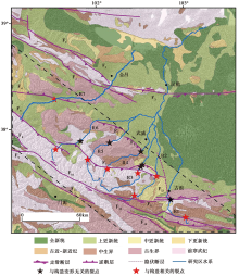
 | 图 3 石羊河流域河流裂点分布断裂及河流标注见图1, 虚线圈闭区域为石羊河流域上游基岩区Fig. 3 Distribution of river knickpoints in the Shiyanghe River Basin. |
通过Snyder等(2000)Kirby等(2003)开发的工具, 从SRTM 30m分辨率的DEM数据中提取7条河流的纵向剖面。使用Matlab脚本和ArcMap对局部河道比降和上游排水区域(logS-logA)进行幂律回归分析, 得到河道凹曲度(θ )和陡峭系数(ks)(Duvall et al., 2004)(式(4), 图2)。选择250m的平均移动窗口以去除尖峰, 并且在20m的相等垂直间隔下计算河道梯度。为了便于对不同河道进行对比并与已发表的研究进行比较, 本文使用0.45的参考空间(θ ref)来计算归一化陡峭系数(ksn)。
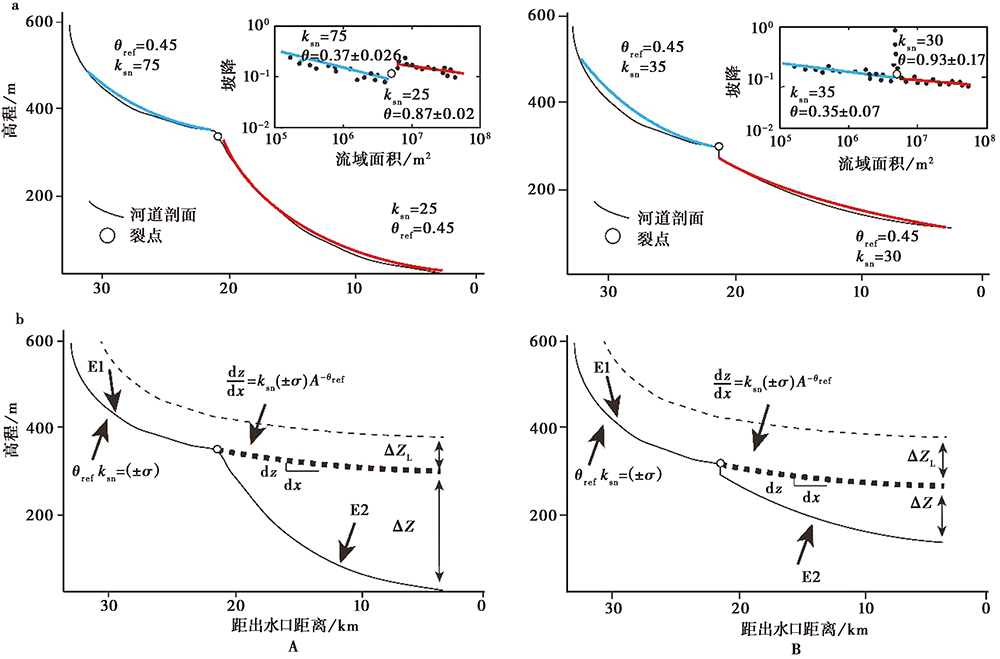 | 图 2 河流纵剖面解译原理(修改自Kirby et al., 2012; Regalla et al., 2013)a 河流纵剖面示意图; b 裂点以下, 河口侵蚀量(Δ Z)以E2的速率, 拟合得侵蚀前纵剖面(粗虚线), 从裂点开始以来古河道以E1的速率侵蚀的侵蚀量(Δ ZL, 细虚线), σ 代表误差。 A为具有坡折式裂点的河流形态, B为具有垂直陡降式裂点的河流形态Fig. 2 Interpretation principle of river longitudinal profiles (adapted after Kirby et al., 2012; Regalla et al., 2013). |
石羊河流域的各条河流流经高山带、 低山带以及走廊平原带(图1), 这些区域的海拔、 地貌、 岩性等有很大差异, 为了综合分析河流对不同地貌单元的响应, 将河流划分为上游、 中游和下游。流域内各条河流的地貌参数如表1所示。
| 表1 石羊河流域河流剖面的地貌参数 Table1 Geomorphic parameters of river longitudinal profiles in the Shiyanghe River Basin |
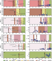
研究区内7条河流的裂点分布如图3所示。裂点与chi图曲线斜率的突然变化有关(Perron et al., 2013; 王一舟等, 2016; Zhang et al., 2017)(图4), 河道陡峭系数的突然变化标志着裂点的存在(Kirby et al., 2012)(图4)。裂点的上、 下河段具有不同的陡峭度(ks)与凹曲度(θ ), 说明在河流纵剖面上裂点上、 下游河段具有不同的发育趋势。除西大河(R7)外, 裂点上游的河道表现出相对均匀的凹曲度(平均凹曲度为 0.458± 0.053)和较高的河流陡峭系数(平均ksn 为 129.09± 1.82)。下游河流陡峭系数较小(平均ksn 为 68.162± 0.821), 比较平缓, 并且具有更大的凹曲度范围(平均凹曲度为 0.831± 0.147)(图4, 表1)。以上河流(R1— R6)均发源于古浪推覆体, 西大河(R7)河道上游岩性均一, 为上更新世岩石, 在经过裂点之后进入山区(古生界岩石区域), ksn 值明显增大。
 | 图 4 石羊河流域7条支流的chi、 河流陡峭系数与岩性叠加图五角星为裂点(其中黑色裂点与构造变形无关)Fig. 4 Chi-elevation, river steepness index and lithological superposition of 7 tributaries in the Shiyanghe River Basin. |
这些裂点所在位置的基岩岩性略有不同(图3, 4, 表2)。古浪河裂点的基岩岩性是肮脏沟组浅变质砂岩和河口群砂岩, 其中上游裂点上、 下游的ksn 值有明显变化, 为坡折式裂点, 与构造变形有关; 下游裂点上、 下游ksn 值并无太大变化, 靠近岩性分界点, 说明该裂点与构造变形无关。黄羊河2个裂点的岩性分别是臭牛沟组泥质岩和奥陶纪斜长花岗岩。杂木河共有3个裂点, 最上游发育于前寒武纪的裂点上、 下游岩性一致, 为坡折式裂点; 发育在古生界岩层中的裂点为垂直陡降型裂点, 其上、 下游ksn 值几乎一致, 说明该裂点与构造变形无关; 下游的裂点发育在古生界和中更新统岩层的交界处, 裂点上、 下游ksn 值无明显变化, 说明该裂点与构造活动无关。金塔河裂点所在位置的岩性为奥陶纪花岗闪长岩, 裂点属坡折式, 其上、 下游ksn 值变化明显, 表明该裂点与构造活动相关; 下游裂点在古生界岩层与上更新统砂土的交界处, 属垂直陡降型, 其上、 下游ksn 值无明显变化, 故该裂点与构造变形无关。东大河上游的裂点所在位置的岩性为奥陶纪花岗闪长岩, 裂点为坡折式; 下游裂点在志留纪二长花岗岩与上更新统砂土的交界处, 其上、 下游ksn 值变化不大, 故该裂点与构造变形无关。西营河裂点岩性为大黄沟组砂岩和古生界岩石, 其中发育在古生界岩石中的裂点为垂直陡降型, 其上、 下游的ksn 值无明显变化, 说明该裂点与构造活动无关。西大河的裂点发育在上更新统砂土层中, 为坡折式裂点, 其上、 下游的ksn 值变化明显, 故该裂点与构造变形相关。为研究石羊河流域的活动构造特征, 下文中对于与构造变形无关的裂点则不予讨论。
| 表2 河流剖面和裂点位置的基岩岩性 Table2 Knickpoints observed in the river profiles and underlying lithology |
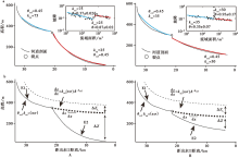
剔除与岩性相关的裂点后, 分别计算其流域基岩河道的河段坡度及河段所对应的上游流域盆地的面积, 得到其logS-logA曲线, 并与相应流域的河流纵剖面进行对比分析, 结果如图5所示。
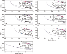
 | 图 5 石羊河流域7条河流实际剖面与拟合剖面R1 古浪河; R2 黄羊河; R3 杂木河; R4 金塔河; R5 西营河; R6 东大河; R7 西大河。蓝色圆圈为裂点所在位置, 红色实线代表实际河道, 蓝色虚线代表拟合河道Fig. 5 Stream profiles and channel profiles of the 7 tributaries in the Shiyanghe River Basin. |
根据各支流的logS-logA曲线, 石羊河流域的7条支流均至少存在 1 个主裂点, 裂点上、 下河段具有不同的陡峭度(ks)与凹曲度(θ ), 说明在河流纵剖面上裂点上、 下游河段具有不同的发育趋势。利用裂点上游河道的凹曲度指标拟合出整条河流, 则该拟合河流的纵剖面代表了地表整体隆升后河流呈现出的纵剖面形态(Harkins et al., 2007; Regalla et al., 2013)。而拟合河道与现今实际下游河道的高程差则代表了地表差异隆升的实际高程差值, 由此得到石羊河流域的平均河道侵蚀量为488m(表3)。这也能反映研究区地表隆升量的大小。
| 表3 石羊河流域各条河流侵蚀量 Table3 Erosion amount of each river in the Shiyanghe River Basin |
河流陡峭系数能够反映构造隆升的大小。归一化的河流陡峭系数(ksn)的增加或减少表示地表抬升的偏差或地貌对扰动的瞬时响应(Kirby et al., 2011)。为了探索石羊河流域中隆升量的分布情况, 本文计算了其河网的ksn 值, 并对结果进行插值(图6)。
 | 图 6 石羊河流域基岩区陡峭系数空间分布Fig. 6 Spatial distribution of steepness index in the upper reaches of the Shiyanghe River Basin. |
结果显示, 古浪河(R1)的陡峭系数向中游逐渐增大, 在毛毛山断裂、 天桥沟黄羊川断裂附近出现最大值, 最大超过600, 随后向下游逐渐减小。黄羊河(R2)的陡峭系数在在中上游比较平缓, 在天桥沟-黄羊川断裂、 皇城-双塔断裂附近发生突变, 最大超过1i200, 随后向下游递减。金塔河(R3)的陡峭系数在上游逐渐递增, 在靠近皇城-双塔断层处出现峰值(> 800), 随后向下游迅速减小。杂木河(R3)、 西营河(R4)的陡峭系数均在靠近皇城-双塔断层处出现峰值(约1i000), 向下游又逐渐减小。东大河(R6)的陡峭系数从上游到中游逐渐增大, 在民乐-大马营断裂附近出现峰值, 到下游又逐渐减小。西大河(R7)的陡峭系数在民乐-永昌断裂激增, 向中游逐渐增大, 到下游逐渐变小。几乎所有的纵向剖面都表现出下游段陡峭系数< 60、 陡峭系数在中游明显大于下游的特征。
河流陡峭系数较高位置的集中分布于古浪推覆体和民乐-大马营断裂(F6)、 肃南-祁连断裂(俄堡段)(F8)、 冷龙岭断裂(F10)所围限的狭窄区域。杂木河(R3)、 金塔河(R4)、 西营河(R5)的上游和中游比其他支流更陡峭。河道陡峭系数总体呈现由上游向下游递减的趋势。在这些河流的上游, 河道陡峭系数> 100m0.9(图6), 表明古浪推覆体经历了强烈的构造抬升。
在河流纵剖面中, 石羊河流域的大部分支流在其中游和下游区域表现出河道比降增加的特征。该模式与瞬态河道纵剖面模型一致, 表明出现了岩石隆起或基准面下降(Harkins et al., 2007)。石羊河流域内的裂点分布表征了河道纵剖面的演变过程。
不同的构造变形控制着不同的地貌演化过程, 而地貌特征也会反映一定的构造活动信息(郑光佑, 2002)。冷龙岭断裂(F10)、 皇城-双塔断裂(F7)以及武威盆地南缘断裂(F5)所控制的祁连山东段向N逆冲的推覆体具有极高的ksn 值。前人研究发现此区域内具有极高的面积高程积分值(HI)(苏琦等, 2017), 揭示了祁连山东段受区域活动断裂所控制发生了强烈隆升, 对于该区地貌形态特征产生了极其重要的影响。凹曲度指数(θ )与岩石隆起直接相关。裂点上游河道的凹曲度平均值约 0.458± 0.053, 说明上游的基岩区位于活跃的造山带中(Snyder et al., 2000; Kirby et al., 2001; Ambili et al., 2014), 而下游河道的凹曲度平均值约 0.831± 0.147, 反映了较高的侵蚀率。河流陡峭系数的区域差异主要受差异岩石隆起速率的控制(Kirby et al., 2003), 前人的研究表明, 河道陡峭系数与岩石隆起速率之间存在正线性相关性(Snyder et al., 2000)。因此, 古浪推覆体上具有高河流陡峭系数的区域较为集中, 则表明此处抬升率较高, 经历了明显的构造抬升过程。石羊河流域河流陡峭系数的空间模式揭示了河道对构造活动的响应。
对于瞬时河流系统, 侵蚀的总量是差异性河流侵蚀加上从裂点以下河道高程的降低之和(Whipple, 2001; Regalla et al., 2013)(图2), 其应与岩石隆升量呈正相关。可以通过投影拟合来重建侵蚀前的纵向剖面(Harkins et al., 2007; Kirby et al., 2012)。对侵蚀速率进行积分可以估计裂点以下古河道降低的最小值(Regalla et al., 2013)(图2)。基于古河道重建(原理如图2), 本文的研究表明石羊河流域的平均河道侵蚀量为488m, 古浪推覆体上各条河流的平均侵蚀量为508.5m。Hetzel等(2006)通过10Be测年得到与研究区毗邻的龙首山地区的侵蚀速率为(155± 25)m/Ma, 胡二伢(2012)通过10Be测年得到祁连山地区5MaiBP以来的侵蚀速率为10~300m/Ma, 由此可知约自3MaiBP开始侵蚀, 这可能预示着古浪推覆体约于3MaiBP也开始隆升。
苏琦等(2016)对地貌因子进行提取、 分析, 指出构造活动是控制黑河流域、 石羊河流域内地貌演化的最主要因素。其利用Matlab脚本对基岩河道裂点上、 下游的河道高程进行拟合、 恢复重建, 得到黑河流域内平均地表差异隆升为540m, 西段(石油河— 马营河)平均地表差异隆升为754m; 东段(摆浪河— 山丹河)平均差异隆升仅有219m, 说明黑河流域西段构造活动强度要远大于东段。本文得到石羊河流域的平均侵蚀量为488m, 指示了研究区的构造强度。前人的研究表明青藏高原东北缘祁连山地区历了多次普遍意义上的重大构造事件, 且这些构造活动在高原北缘具有整体同步性特征(宋春晖, 2006), 祁连山北缘断裂呈现出由西向东逆冲分量逐渐减小的特征(刘百篪等, 2008), 在构造隆升幅度和强度上存在 “ 西强东弱” 的特点(Hetzel et al., 2006; 胡小飞等, 2010; 苏琦等, 2016)。综合前人的研究成果(胡小飞等, 2013; 苏琦等, 2016, 2017), 我们得到的河流纵剖面的恢复重建及综合地貌参数结果也反映了祁连山中东段的构造活动存在逐渐减弱的趋势。
本文利用1角秒 SRTM(30m)数字高程模型数据提取了祁连山东段石羊河流域的河流纵剖面及河流陡峭系数等宏观地貌参数并分析了该区地貌所蕴含的地质意义。研究认为:
(1)河流纵剖面分析表明石羊河的地貌演变处于瞬时状态。上部和下部各点之间的陡峭系数和凹曲度指数的变化表明, 由构造引起的基准面的变化可能影响河道纵剖面的演变, 而裂点的分布可能反映了石羊河的整体隆起但区域隆升速率不同。
(2)河道的拟合表明, 自早更新世晚期以来, 石羊河流域经历了隆升过程, 构造活动是祁连山东段地貌演化的主控因素, 通过拟合结果计算出石羊河流域平均河道侵蚀量约为488m。
(3)祁连山东段地貌参数结果表明古浪推覆体经历了强烈的构造抬升, 这可能是自新生代晚期以来连续构造调整的结果。
致谢 审稿专家对本文提出了建设性意见, 在此表示衷心感谢!
The authors have declared that no competing interests exist.
| 1 |
|
| 2 |
|
| 3 |
|
| 4 |
|
| 5 |
|
| 6 |
|
| 7 |
|
| 8 |
|
| 9 |
|
| 10 |
|
| 11 |
|
| 12 |
|
| 13 |
|
| 14 |
|
| 15 |
|
| 16 |
|
| 17 |
|
| 18 |
|
| 19 |
|
| 20 |
|
| 21 |
|
| 22 |
|
| 23 |
|
| 24 |
|
| 25 |
|
| 26 |
|
| 27 |
|
| 28 |
|
| 29 |
|
| 30 |
|
| 31 |
|
| 32 |
|
| 33 |
|
| 34 |
|
| 35 |
|
| 36 |
|
| 37 |
|
| 38 |
|
| 39 |
|
| 40 |
|
| 41 |
|
| 42 |
|
| 43 |
|
| 44 |
|
| 45 |
|
| 46 |
|
| 47 |
|
| 48 |
|
| 49 |
|
| 50 |
|
| 51 |
|
| 52 |
|
| 53 |
|
| 54 |
|
| 55 |
|
| 56 |
|
| 57 |
|
| 58 |
|
| 59 |
|
| 60 |
|
| 61 |
|
| 62 |
|
| 63 |
|
| 64 |
|
| 65 |
|
| 66 |
|
| 67 |
|
| 68 |
|
| 69 |
|
| 70 |
|
| 71 |
|
| 72 |
|
| 73 |
|
| 74 |
|
| 75 |
|
| 76 |
|
| 77 |
|
| 78 |
|
| 79 |
|
| 80 |
|
| 81 |
|
| 82 |
|
| 83 |
|
| 84 |
|
| 85 |
|
| 86 |
|
| 87 |
|
| 88 |
|
| 89 |
|
| 90 |
|
| 91 |
|
| 92 |
|
| 93 |
|
| 94 |
|
| 95 |
|
| 96 |
|
| 97 |
|
| 98 |
|
| 99 |
|
| 100 |
|
| 101 |
|
| 102 |
|
| 103 |
|
| 104 |
|
| 105 |
|
| 106 |
|
| 107 |
|