冲积扇河流阶地演化对走滑断裂断错位移的限定
许斌斌1), 张冬丽1),*, 张培震1), 郑文俊1), 毕海芸2), 田晴映1), 张逸鹏1), 熊建国2), 李志刚1)
1)中山大学地球科学与工程学院, 广东省地球动力作用与地质灾害重点实验室, 广州 510275
2)中国地震局地质研究所, 地震动力学国家重点实验室, 北京 100029
*通讯作者: 张冬丽, 女, 1974年生, 副教授, 主要从事工程地震、 地震灾害机理与近场强地震动数值模拟等研究, 电话:020-84111351, E-mail:zhangdongli@mail.sysu.edu.cn

〔作者简介〕 许斌斌, 男, 1994生, 2017年于中山大学地球科学与工程学院获地球信息科学与技术专业学士学位, 主要从事构造地貌、 活动构造方面的研究, 电话: 15622113353, E-mail: xubb3@mail2.sysu.edu.cn

摘要

滑动速率是活动断裂定量研究的重要参数, 是指在一段时间内断裂两盘相对运动的平均速度, 是断裂带上应变能累积速率的重要表现, 常被用于评价断裂的地震危险性。 区域河流地貌特征及水系演化会受到构造活动的显著影响, 因此分析河流地貌演化是研究构造变化特征的重要方法, 也是限定断裂滑动速率较为可靠的方法。 在总结河流地貌演化过程模式的基础上, 考虑地形地貌因素的影响, 建立了河流阶地位错模式和位错量的测量方法, 并以阿尔金断裂东端断裂近垂直穿过的高岩沟为例, 建立了其河流阶地的演化过程及其与断裂位错的关系, 得到了不同阶地因断裂活动形成的位错量。 结合前人的阶地测年结果, 估算得到了阿尔金断裂在该段的水平滑动速率为(1.80±0.51)mm/a。

关键词: 河流层状地貌; 走滑断裂; 断错位移; 地形效应; 阿尔金断裂
中图分类号:P315.2 文献标志码:A 文章编号:0253-4967(2019)03-0587-16
SLIP OFFSET ALONG STRIKE-SLIP FAULT DETERMINED FROM STREAM TERRACES FORMATION
XU Bin-bin1), ZHANG Dong-li1), ZHANG Pei-zhen1), ZHENG Wen-jun1), BI Hai-yun2), TIAN Qing-ying1), ZHANG Yi-peng1), XIONG Jian-guo2), LI Zhi-gang1)
1)Guangdong Provincial Key Laboratory of Geodynamics and Geohazards, School of Earth Sciences and Engineering, Sun Yat-Sen University, Guangzhou 510275, China
2)State Key Laboratory of Earthquake Dynamics, Institute of Geology, China Earthquake Administration, Beijing 100029, China
Abstract

Slip rate is one of the most important parameters in quantitative research of active faults. It is an average rate of fault dislocation during a particular period, which can reflect the strain energy accumulation rate of a fault. Thus it is often directly used in the evaluation of seismic hazard. Tectonic activities significantly influence regional geomorphic characteristics. Therefore, river evolution characteristics can be used to study tectonic activities characteristics, which is a relatively reliable method to determine slip rate of fault. Based on the study of the river geomorphology evolution process model and considering the influence of topographic and geomorphic factors, this paper established the river terrace dislocation model and put forward that the accurate measurement of the displacement caused by the fault should focus on the erosion of the terrace caused by river migration under the influence of topography. Through the analysis of the different cases in detail, it was found that the evolution of rivers is often affected by the topography, and rivers tend to migrate to the lower side of the terrain and erode the terraces on this side. However, terraces on the higher side of the terrain can usually be preserved, and the displacement caused by faulting can be accumulated relatively completely. Though it is reliable to calculate the slip rate of faults through the terrace dislocation on this side, a detailed analysis should be carried out in the field in order to select the appropriate terraces to measure the displacement under the comprehensive effects of topography, landform and other factors, if the terraces on both sides of the river are preserved. In order to obtain the results more objectively, we used Monte Carlo method to estimate the fault displacement and displacement error range. We used the linear equation to fit the position of terrace scarps and faults, and then calculate the terrace displacement. After 100, 000 times of simulation, the fault displacement and its error range could be obtained with 95%confidence interval. We selected the Gaoyan River in the eastern Altyn Tagh Fault as the research object, and used the unmanned air vehicle aerial photography technology to obtain the high-resolution DEM of this area. Based on the terrace evolution model proposed in this paper, we analyzed the terrace evolution with the detailed interpretation of the topography and landform of the DEM, and inferred that the right bank of the river was higher than the left bank, which led to the continuous erosion of the river to the left bank, while the terraces on the right bank were preserved. In addition, four stages of fault displacements and their error ranges were obtained by Monte Carlo method. By integrating the dating results of previous researches in this area, we got the fault slip rate of(1.80±0.51)mm/a. After comparing this result with the slip rates of each section of Altyn Tagh Fault studied by predecessors, it was found that the slip rate obtained in this paper is in line with the variation trend of the slip rate summarized by predecessors, namely, the slip rate gradually decreases from west to east, from 10~12mm/a in the middle section to about 2mm/a at the end.

Keyword: offset stream terraces; strike-slip fault; slip offset; topographic effect; Altyn Tagh Fault
0 引言

自20世纪70年代至今, 活动构造研究已从定性描述逐步发展到定量化研究阶段(邓起东等, 2004)。 断裂运动的长期平均滑动速率体现了断裂带上应变能累积的速率, 常被用于评价地震危险性等(Molnar, 1978; Anderson, 1979; Peng et al., 2012)。 此外, 平均滑动速率也是研究地壳变形的重要依据。 以青藏高原为例, 不同研究者在各自得到的不同断裂滑动速率的基础上, 提出了不同的变形模式(Molnar et al., 1975; England et al., 1986, 1997; Peltzer et al., 1988; Tapponnier et al., 2001; van der Woerd et al., 2002; Zhang et al., 2004; 张培震等, 2008; Gold et al., 2009; 郑文俊等, 2009, 2016; Hetzel, 2013; Zheng et al., 2013a, b, c)。 因此, 定量研究断裂滑动速率有着重要的地质意义。

目前, 断裂全新世滑动速率主要利用地貌面的总位移量除以其累积时间来限定(Allen, 1962; Huang, 1993; Maruyama et al., 2000, 2002; Yan et al., 2015)。 洪积扇、 河流阶地面上细小冲沟的位错通常是断裂近期活动的标志, 可作为未来发震的可能性、 强度等相关研究的有力依据(Weldon et al., 1985; Huang, 1993; 张培震等, 2008; Li et al., 2009)。 大的走滑位错往往记录着多次重复发生的走滑断裂水平错动, 因此详细研究河流阶地的演化过程, 准确获取地貌面的位错量, 并结合河流阶地中的时间信息, 则有可能限定较长时期内断裂的平均滑动速率(Zhang et al., 1995; Maruyama et al., 2000, 2002; 张培震等, 2008; Li et al., 2009; 任治坤等, 2014)。 此外, 在河流演化过程中, 由于受断裂活动影响, 河流经常有袭夺和重组现象, 乃至出现断头沟或断尾沟(Costa et al., 1982; 张培震等, 2008)。 通过拼接复原被错断的水系和地貌, 得到不同时期内的位错量, 可估算得到断裂的长期平均滑动速率(Allen et al., 1984; Zhang et al., 1995; Replumaz et al., 2001; Maruyama et al., 2002; Frankel et al., 2007; Klinger et al., 2011)。 本文通过分析河流阶地及冲沟演化对走滑断裂活动的响应, 同时考虑地形因素的影响, 建立走滑断裂滑动速率的获取方法, 并将此方法运用于阿尔金断裂东端通过的高岩沟, 获取该断裂全新世以来的滑动速率。

1 河流阶地的成因与演化概述

河流下切侵蚀, 原先的河谷底部(河漫滩或河床)超出一般洪水位以上, 呈阶梯状分布在河谷谷坡上, 这种地貌称为河流阶地(杨景春等, 2012)。 河流发育到一定阶段, 河床侧蚀迂回, 展宽河谷, 河流暂时接近相对平衡状态, 这时进入河流的冲积物和河流搬运的冲积物近似相等。 当进入河流的冲积物多于河流搬运的冲积物, 即河流以侧蚀作用和堆积作用为主时, 则会在河床上形成河漫滩和冲积层; 当进入河流的冲积物少于河流搬运的冲积物, 河流加速侵蚀, 河漫滩就会因为下切转化为河流阶地而被废弃。 国内外诸多学者将河流下切形成阶地归因于构造运动、 气候变化和地方性侵蚀基准面的下降等, 构造运动会增大河道比降, 促使河流加速下切, 河漫滩就有可能被废弃形成阶地(Rockwell et al., 1988; England et al., 1990; Burbank et al., 1996; Hetzel et al., 2002; 李有利等, 2012); 气候变化主要通过降雨等方式影响河流水量, 使得河流的水动力增强, 河流加速下切, 以此影响河流的地貌演化(Whipple et al., 2000; Pan et al., 2003, 2007, 2009; 李有利等, 2012; Hu et al., 2015); 地方性侵蚀基准面的下降可由构造运动和气候变化共同作用导致, 也可通过增大河道比降, 使得河流加速下切形成阶地(Chappell, 1983; 李有利等, 2012; 田晴映等, 2017)。

国内外诸多学者的研究表明, 河流阶地的形成演化往往会受到地壳变形的影响, 不同的构造活动方式会导致不同的阶地变形(Burnett et al., 1983; Antoine et al., 2000; Maddy et al., 2000; 郑文涛等, 2000; 杨景春等, 2012)。 在同一时期内, 地壳大面积均匀上升的地区, 河流普遍下切侵蚀, 在河流的整个流域内都将形成阶地: 如果某地区地壳上升幅度大、 速度快, 而另一地区上升幅度小、 速度慢, 那么前一地区的阶地高度比后一地区大; 如果不同地段的构造运动方向不一致, 上升地区将会形成侵蚀或基座阶地, 下降地区形成埋藏阶地; 如果河流的某一段受褶皱构造抬升影响, 那么阶地将在这一段呈上拱状, 反映出褶皱变形的形态, 而且阶地的级数也可能增加; 如果活动断裂横断河谷, 阶地在穿过断裂时会被错断, 如果断裂有水平或垂向上的运动, 阶地面则可能在水平或垂向上表现出不连续的特征(胡小飞, 2010; 吕红华等, 2010; 李有利等, 2012; 刘兴旺等, 2013; Pan et al., 2013; 李涛等, 2014; 张天琪等, 2014; 田晴映等, 2017)。

2 河流阶地的演化对走滑断裂活动的地貌响应

国内外诸多学者通过分析河流阶地对走滑断裂的响应, 计算得到了较为准确的断裂滑动速率, 认为河流阶地的演化与走滑断裂之间有很好的响应(van der Woerd et al., 2002; 徐锡伟等, 2003; Cowgill, 2007; Zhang et al., 2007; 张培震等, 2008)。 目前, 学者们主要通过重建地形地貌, 分析其演化过程的方式来计算断裂滑动速率(Lensen, 1968; Cowgill, 2007; 李海兵等, 2008; 张培震等, 2008), 但是在地貌重建过程中存在不确定性, 最后可能导致滑动速率相差甚远(Zhang et al., 2007; 张培震等, 2008)。 很多学者已经注意到这一问题, 并着重分析河流的演化过程以建立不同的计算模式, 根据不同河流的演化过程, 利用不同的地貌重建模式进行计算。 其中, Cowgill(2007)Zhang等(2007)李海兵等(2008)对这些演化模式进行了总结, 提出了高阶地再建模式和低阶地再建模式, 并可通过高、 低阶地进行控制得到可靠的滑动速率范围。

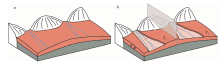
针对基座阶地, Zhang等(2007)提出了一种河流演化模式, 也是目前利用河流阶地研究断裂滑动速率较为可靠的方法: 山前河流被活动断裂错断, 在继续下切形成阶地前, 断裂下游盘被断裂错入河道的一侧阶地会受到河流侵蚀, 另一侧阶地被断裂错离河道, 受到地貌保护而免遭侵蚀, 断裂位移在错离河道一侧的阶地陡坎上进行积累。 但是, 结合野外调查发现, 河流被断裂错断后演化结果不尽相同, 这是由于出山口的冲洪积扇形态由出山口向外辐射, 中间高、 两边低, 发育在洪积扇两侧的河流被断裂错断后, 受地形控制发生迁移而进行侧蚀, 将演化得到不同的阶地样式(图1)。 因此, 本文在Zhang等(2007)提出的河流演化模式基础之上加入对地形的考虑, 进一步分析河流阶地对走滑断裂的响应。

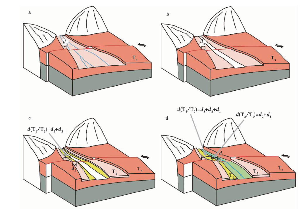
图 1 冲洪积扇的基本形态及阶地发育Fig. 1 The basic form and terrace evolution of alluvial fan.

图1a展示了冲洪积扇的基本形态, 假定左、 右扇体各发育有1条河流, 在这2条河流的下切和堆积作用的影响下, 形成T3, 如图1b所示。 此后这2条河流受到同一断裂左旋错动的影响, 表现出不同的演化过程:

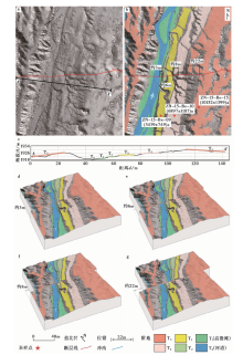
(1)以左扇体为例(图1b左侧), 被错离河道一侧的阶地(左岸阶地)高于被错入河道一侧的阶地(右岸阶地)。 T3被断裂错断, 导致阶地出现位错d3(图2a), 受到右岸低、 左岸高的地形影响, 河流向右岸迁移, 右岸阶地遭受侧蚀, 导致下游盘的右岸阶地陡坎逐渐后退(图2b)。 河流发生进一步的下切和堆积作用, 新的阶地T2开始形成, 断裂继续活动导致T2出现位错d2, T3积累位错为d3+d2(图2c)。 在断裂持续活动下, 下级阶地重复T3和T2的演化过程, 河流左岸的阶地陡坎会不断积累断裂的左旋走滑位移, 而右岸阶地遭受侧蚀。 这一分析得到的河流演化结果与Zhang等(2007)提出的理想的河流演化模式结果一致。

图 2 错离河道的一侧高于错入河道的一侧的阶地演化(据Zhang et al., 2007修改)Fig. 2 The terrace evolution while the offset side is higher than the other(adapted after Zhang et al., 2007).

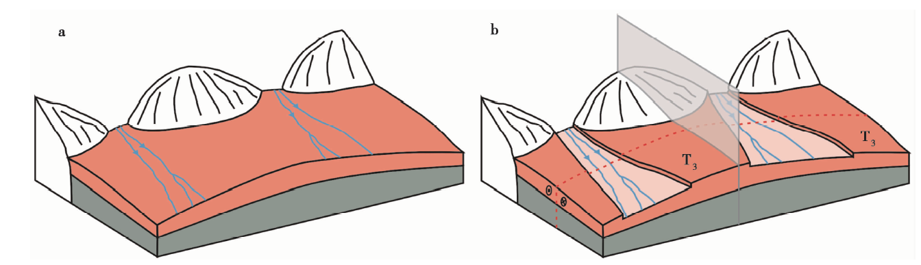
(2)以右扇体为例(图1b右侧), 被错入河道一侧的阶地(右岸阶地)高于被错离河道一侧的阶地(左岸阶地)。 T3被断裂错断, 导致阶地出现位错d3(图3a)。 河流右岸地形高于左岸, 河流逐渐向左岸迁移, 河流的左岸阶地遭受侧蚀, 使得左岸阶地陡坎不断后退(图3b)。 河流发生进一步的下切和堆积作用, 新的阶地T2开始形成, 断裂继续活动导致T2出现位错d2, T3积累位错为d3+d2(图3c)。 在断裂持续的左旋错动下, 下级阶地重复T3和T2的演化过程, 河流左岸阶地陡坎因受到河流侵蚀而不断后退, 右岸阶地陡坎则不断积累断裂的左旋走滑位移。 这一分析得到的河流演化结果与Zhang等(2007)提出的理想的河流演化模式结果不同。

图 3 错入河道的一侧高于错离河道的一侧的阶地演化Fig. 3 The terrace evolution while the offset side is lower than the other.

因此, 准确测量阶地因断裂错动产生的位错量, 需要重点考虑河流在地形影响下对阶地的侵蚀情况。 通过上面的分析可见, 地形较高一侧的阶地通常能够被保存下来, 并较为完整地积累断裂位移量, 通过该侧的阶地位错量计算断裂的滑动速率较为可靠。 对于河流两侧阶地均保留的情况, 则需要在野外进行详细的分析, 综合地形、 地貌等因素的影响, 选取合适的一侧阶地进行测量。

3 考虑地形因子的阶地位错测量和误差计算

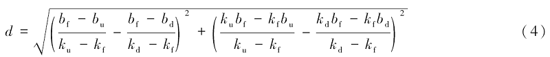
对地貌位错的准确测量是计算断裂滑动速率和研究断裂活动性的重要条件。 对于阶地位错的测量, 通常选取断裂两盘对应的阶地前缘作为线性标志(Sieh et al., 1984; Weldon et al., 1985; Mé riaux et al., 2004; 张培震等, 2008)。 为了获得阶地前缘的位错量, 即断裂的水平位错量, 通常利用研究区的正射影像(或DEM影像)进行详细的地貌解译, 得到各阶地前缘的位置与断裂的走向, 用以计算断裂的各种活动参数(Mé riaux et al., 2004; Zhang et al., 2007; 张培震等, 2008; 毕海芸等, 2017)。 利用图 4所示的模式图对断裂的水平位错量进行计算, 具体方法如下: 首先假设阶地在被错断之前, 阶地前缘是连续平直的, 然后通过断裂两盘的阶地前缘和断裂的平面坐标在水平面上进行线性拟合得到相应的线性公式(图4b):

上游盘阶地前缘:

y=ku·x+bu(1)

下游盘阶地前缘:

y=kd·x+bd(2)

断裂:

y=kf·x+bf(3)

此时, 根据阶地前缘和断裂的交点计算水平位错量为

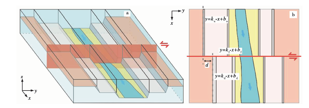
图 4 阶地位错测量原理图
a 理想阶地位错模型, 以左旋走滑为例; b 图a模型的俯视图
Fig. 4 Principle diagram of terrace dislocation measurement.

在误差分析过程中, 常用的方法是利用测量方程推导出误差传递方程, 再通过不确定度的合成公式获得间接测量值的标准不确定度和扩展不确定度。 因此在有些情况下, 研究误差的特性需要借助模拟统计的方式进行计算。 本文使用蒙特· 卡洛(Monte Carlo)模拟进行误差计算。 这种模拟误差的方法是根据各自变量的概率分布进行随机抽样, 计算因变量, 通过多次重复抽样计算获得统计样本的分布, 利用样本的概率分布得出包括置信区间在内的各统计量。 这种误差计算方法可以同时考虑计算中所有自变量的误差。 由于变量kubukdbd与阶地前缘的分布有关, 可分析和统计断裂两盘的阶地陡坎形态, 进而进行线性拟合得到其阶地前缘的分布。 如图4b所示, 上游盘的阶地陡坎较陡, 下游盘阶地陡坎较缓, 可以统计得到不同的分布; 由于变量kfbf的取值分布与断裂的形态和位置相关, 可以对断裂的形态和位置进行统计计算得到这2个变量的分布。 在计算断裂滑动速率时, 每次模拟抽样计算100 000次, 取95%置信区间。

4 阿尔金断裂东端高岩沟

阿尔金活动断裂带是青藏高原北部边界的大型左旋走滑断裂带, 也是欧亚板块板内活动断裂中左旋走滑最显著的断裂带(Molnar et al., 1975; 丁国瑜, 1995; Wittlinger et al., 1998; Tapponnier et al., 2001; Cowgill, 2007; 徐锡伟等, 2007; Zhang et al., 2007; Zheng et al., 2013c)。 该断裂西起西藏北部的郭扎错附近, 东至甘肃玉门的宽滩山一带, 在卫星影像上清晰可见, 由一系列断裂段组成, 全长1 500km, 总体呈NEE向(N60° ~70° E)展布。 在断裂北侧可以清晰地看到昌马洪积扇上的河流演化呈现逐渐向东侧发育的趋势, 表现为单侧发育的现象, 这是前文提及的洪积扇中间高、 两边低的地形形态所导致的。 可以看出, 洪积扇的地形形态对河流的演化有着显著的影响。 本文选取阿尔金断裂东端疏勒河以东22km左右的高岩沟为例(图5), 该河流的发育因受到地形的影响, 其演化结果与Zhang等(2007)提出的被错离河道一侧阶地会被保留的特征不一致, 这是由于该地区的地形右高左低, 河流逐渐向左侧迁移, 左侧的阶地不断遭受侵蚀而未能保留。 因此, 需要结合本文阐述的河流阶地演化对断裂位错的响应和位错测量方法进行研究。

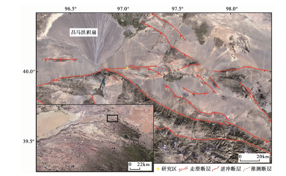
图 5 阿尔金断裂东段区域构造图
图中断裂资料来自文献(Zheng et al., 2013c); 影像资料来自https: ∥glovis.usgs.gov/
Fig. 5 Regional tectonic map of eastern Altyn Tagh Fault.

本文利用近年来新兴的无人机摄影测量方法对研究区进行测量(陈桂华等, 2006; 刘华国等, 2011; 毕海芸等, 2017; Bi et al., 2018), 得到了研究区的数字高程模型(DEM)(图6a), 并进行仔细的地貌解译(图6b), 垂直河道作剖面A-A', 如图6c所示, 河流的右岸明显高于左岸, 与图 3所示的模型一致。 由于在断层上盘和下盘, 河道的左岸均遭受了明显的侧蚀, 河流右岸高于左岸导致了河道的迁移, 使得河流右岸(即被错入河道的一岸)的阶地T2— T5得以保留, 在断裂持续的左旋错动影响下, 在河流的右岸积累了相应的断裂位移; 而在河流的左岸(即错离河道的一岸)仅有最高级阶地T5保留, 其他阶地均完全被侵蚀, 未积累断裂位移。 通过分析该河流的演化历史, 进行简单的阶地恢复(图6d— g), 在河流的右岸测量得到了各级阶地积累的断裂位移(表1)。 为准确测量断裂的位错并估计误差, 对断裂的形态和位置进行了统计(图7a, b), 利用式(5)和各自变量参数的分布形态对各阶地的位错量和误差进行了蒙特· 卡洛模拟计算, 计算结果取95%的置信区间。 经计算, 得到T2— T5的阶地位错量分别为: (3.45± 1.75)m、 (6.15± 1.34)m、 (8.14± 1.63)m和(22.60± 5.96)m(图7c— f)。

图 6 高岩沟地貌解译及阶地演化过程复原图
a 高岩沟区域高精度DEM; b 高岩沟区域地貌解译; c 图a中AA‘剖面线; d T2阶地复原及位错测量; e T3阶地复原及位错测量; f T4阶地复原及位错测量; g T5阶地复原及位错测量
Fig. 6 Geomorphologic interpretation and terrace evolution reconstruction of Gaoyan River.

表1 各阶地位错量的测量值及蒙特· 卡洛(MC)模拟值、 测年结果和滑动速率计算结果 Table1 Terraces dislocation measurement values, Monte Carlo simulation values, dating results and slip rate

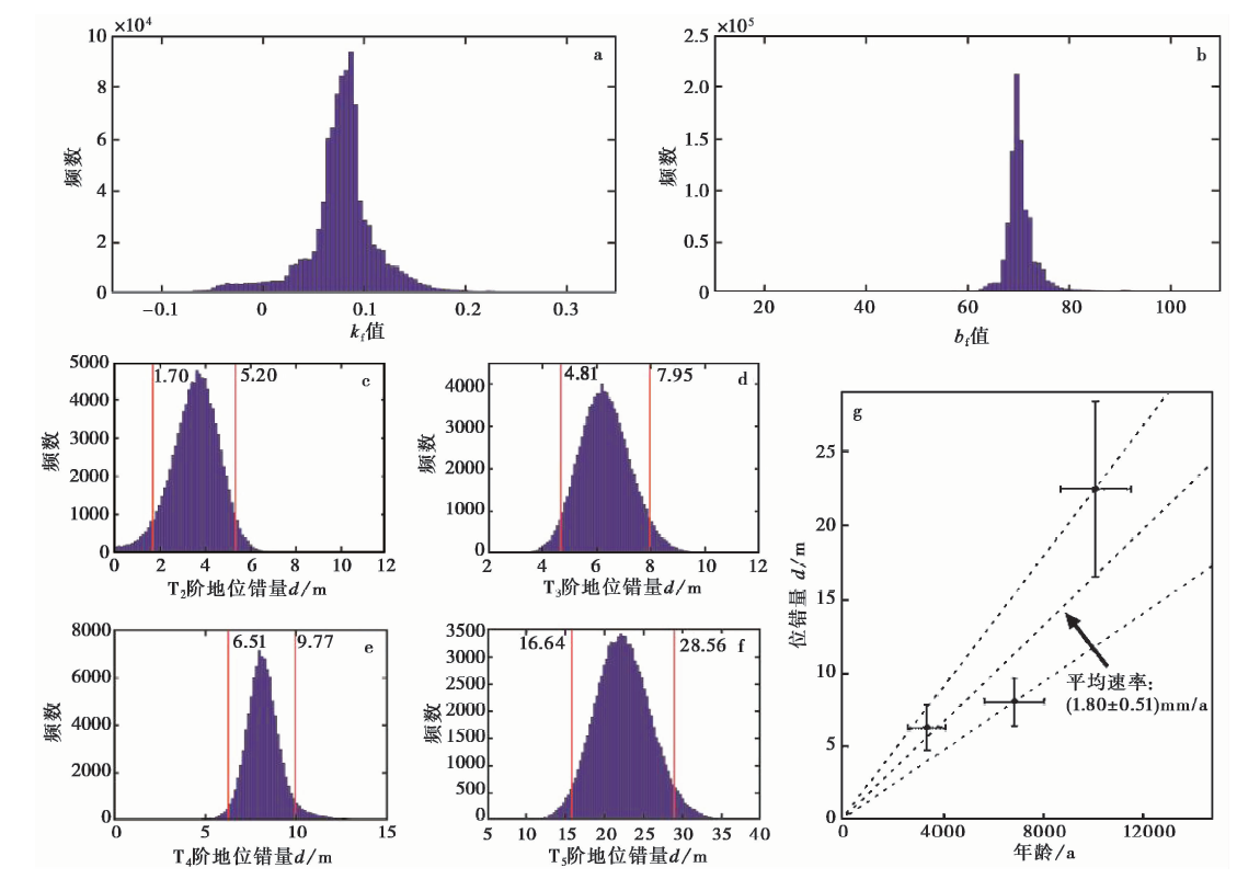
图 7 断裂相关变量分布统计、 各阶地位错分布结果及断裂滑动速率计算
a kf值的统计分布特征; b bf值的统计分布特征, 以坐标[332 290, 4 432 370]为坐标原点, 以减小误差; c T2值的统计分布特征; d T3值的统计分布特征; e T4值的统计分布特征; f T5值的统计分布特征; g 断层滑动速率计算结果
Fig. 7 Fault variables distribution, terraces dislocation distribution and fault slip rate.

由于难以定量确定流水对阶地陡坎冲刷侵蚀的程度, 不同研究者对阶地陡坎累计位错的起始时间持有不同的观点(van der Woerd et al., 2002; Cowgill, 2007; Zhang et al., 2007; 张培震等, 2008), 李海兵等(2008)根据河流阶地的演化及其对走滑断裂错动的响应过程分析讨论了这一问题。 本研究对该地区进行了详细的野外调查, 利用相邻的阶地陡坎除以上级阶地的废弃年龄得到断裂的滑动速率。 参考张宁(2016)在该地区利用宇宙成因核素方法获得的阶地面年龄(图6a, 表1), 计算得到该地区的阿尔金断裂滑动速率为(1.80± 0.51)mm/a(图7g)。 将这一结果与前人得到的阿尔金断裂各段的滑动速率进行对比后发现, 本文得到的滑动速率符合前人总结的滑动速率的变化趋势, 即自西向东的速率逐渐减小, 由中段的10~12mm/a迅速下降至端部的2mm/a左右(Zhang et al., 2007; Zheng et al., 2013c)。

5 结论

本文通过分析河流阶地对断裂走滑位移的响应, 充分考虑地形地貌因素的影响, 讨论不同地形情况下河流阶地对走滑断裂位错的响应结果, 认为利用地形较高一侧的阶地积累的位错量计算断裂滑动速率较为可靠, 并提出了利用蒙特· 卡洛方法计算阶地位错量并估计误差的方法, 可以更为准确有效地给出阶地位错的范围。 本文以阿尔金断裂东端高岩沟为研究实例, 通过野外踏勘, 认为应采用陡坎上级阶地的废弃年龄限定开始积累位移的年代, 并结合模拟计算得到的各阶地位错量, 得到该地区阿尔金断裂平均滑动速率为(1.80± 0.51)mm/a。

致谢 论文写作过程得到中山大学地球科学与工程学院李涛博士和王洋博士的帮助; 数据计算处理方法得到了中山大学地球科学与工程学院张博譞博士的帮助。 在此一并表示感谢!

参考文献
[1] 毕海芸, 郑文俊, 曾江源, . 2017. SfM摄影测量方法在活动构造定量研究中的应用[J]. 地震地质, 39(4): 656-674. doi: 103969/j. issn. 0253-4967. 2017. 04. 003.
BI Hai-yun, ZHENG Wen-jun, ZENG Jiang-yuan, et al. 2017. Application of SfM photogrammetry method to the quantitative study of active tectonics[J]. Seismology and Geology, 39(4): 656-674(in Chinese). [本文引用:2]
[2] 陈桂华, 徐锡伟, 闻学泽, . 2006. 数字航空摄影测量学方法在活动构造中的应用[J]. 地球科学(中国地质大学学报), 31(3): 405-410.
CHEN Gui-hua, XU Xi-wei, WEN Xue-ze, et al. 2006. Application of digital aerophotogrammetry in active tectonics[J]. Earth Science(Journal of China University of Geosciences), 31(3): 405-410(in Chinese). [本文引用:1]
[3] 邓起东, 陈立春, 冉勇康. 2004. 活动构造定量研究与应用[J]. 地学前缘, 11(4): 383-392.
DENG Qi-dong, CHEN Li-chun, RAN Yong-kang. 2004. Quantitative studies and applications of active tectonics[J]. Earth Science Frontiers, 11(4): 383-392(in Chinese). [本文引用:1]
[4] 丁国瑜. 1995. 阿尔金活断层的古地震与分段[J]. 第四纪研究, 15(2): 97-106.
DING Guo-yu. 1995. Paleoearthquakes along the Altun active fault and its segmentation[J]. Quaternary Sciences, 15(2): 97-106(in Chinese). [本文引用:1]
[5] 胡小飞. 2010. 祁连山北部侵蚀速率的时空分布与构造抬升变形研究 [D]. 兰州: 兰州大学.
HU Xiao-fei. 2010. Researches on temporal and spatial distributions of erosion rates and tectonic deformation in the northern Qilian Shan [D]. Lanzhou University, Lanzhou(in Chinese). [本文引用:1]
[6] 李海兵, van der Woerd J, 孙知明, . 2008. 阿尔金断裂带康西瓦段晚第四纪以来的左旋滑移速率及其大地震复发周期的探讨[J]. 第四纪研究, 28(2): 197-213.
LI Hai-bing, van der Woerd J, SUN Zhi-ming, et al. 2008. Late Quaternary left-slip rate and large earthquake recurrence time along the Kangxiwar(Orkarakax)segment of the Altyn Tagh Fault, northern Tibet[J]. Quaternary Sciences, 28(2): 197-213(in Chinese). [本文引用:3]
[7] 李涛, 陈杰. 2014. 利用河流阶地限定活动逆断层相关褶皱晚第四纪变形机制和速率: 方法与认识[J]. 地震地质, 36(2): 478-488. doi: 103969/j. issn. 0253-4967. 2014. 02. 016.
LI Tao, CHEN Jie. 2014. Using deformed fluvial terraces to constrain growth mechanism and rates of thrust related fold: Methods and recognition[J]. Seismology and Geology, 36(2): 478-488(in Chinese). [本文引用:1]
[8] 李有利, 司苏沛, 吕胜华, . 2012. 构造运动和气候变化对天山北麓奎屯河阶地发育的影响作用[J]. 第四纪研究, 32(5): 880-890.
LI You-li, SI Su-pei, Sheng-hua, et al. 2012. Tectonic and climatic controls on the development of the Kuitun River terraces in the northern piedmont of Tianshan Mountains[J]. Quaternary Sciences, 32(5): 880-890(in Chinese). [本文引用:4]
[9] 刘华国, 冉勇康, 李安, . 2011. 基于P5像对与GeoEye-1影像的近地表地层产状的提取[J]. 地震地质, 33(4): 951-962. doi: 103969/j. issn. 0253-4967. 2011. 04. 018.
LIU Hua-guo, RAN Yong-kang, LI An, et al. 2011. Attitude extraction of shallow stratum based on P5 stereo images and GeoEye-1 image[J]. Seismology and Geology, 33(4): 951-962(in Chinese). [本文引用:1]
[10] 刘兴旺, 袁道阳, 潘保田, . 2013. 由黄河阶地变形反映的兰州盆地活动构造特征[J]. 兰州大学学报(自然科学版), 49(4): 459-464.
LIU Xing-wang, YUAN Dao-yang, PAN Bao-tian, et al. 2013. Active tectonic features in Lanzhou Basin reflected by Yellow River terrace deformation[J]. Journal of Lanzhou University(Natural Sciences), 49(4): 459-464(in Chinese). [本文引用:1]
[11] 吕红华, 李有利. 2010. 天山北麓活动背斜带的变形特征[J]. 第四纪研究, 30(5): 1003-1011.
Hong-hua, LI You-li. 2010. Tectonic deformation of active fault related fold belts in the north piedmont of the central Tianshan Mountains, NW China[J]. Quaternary Sciences, 30(5): 1003-1011(in Chinese). [本文引用:1]
[12] 任治坤, 张竹琪, 陈涛, . 2014. 侧向侵蚀相关的走滑断裂滑动速率计算新方法[J]. 地震地质, 36(4): 1020-1028. doi: 103969/j. issn. 0253-4967. 2014. 04. 007.
REN Zhi-kun, ZHANG Zhu-qi, CHEN Tao, et al. 2014. A new method for determining slip rates of strike-slip fault associated with lateral erosion of accumulated offset[J]. Seismology and Geology, 36(4): 1020-1028(in Chinese). [本文引用:1]
[13] 田晴映, 郑文俊, 张冬丽, . 2017. 构造活动和气候变化对河流阶地发育的影响: 以祁连山北缘洪水坝河和马营河为例[J]. 地震地质, 39(6): 1283-1296. doi: 103969/j. issn. 0253-4967. 2017. 06. 013.
TIAN Qing-ying, ZHENG Wen-jun, ZHANG Dong-li, et al. 2017. Influence of tectonics and climate on the evolution of fluvial terraces: A case study of the Hongshuiba and Maying Rivers in the northern margin of the Qilian Mountains[J]. Seismology and Geology, 39(6): 1283-1296(in Chinese). [本文引用:2]
[14] 徐锡伟, Tapponnier P, van der Woerd J, . 2003. 阿尔金断裂带晚第四纪左旋走滑速率及其构造运动转换模式讨论[J]. 中国科学(D辑), 33(10): 967-974.
XU Xi-wei, Tapponnier P, van der Woerd J, et al. 2003. Late Quaternary sinistral slip rate along the Altyn Tagh Fault and its structural transformation model[J]. Science in China(Ser D), 33(10): 967-974(in Chinese). [本文引用:1]
[15] 徐锡伟, 于贵华, 陈桂华, . 2007. 青藏高原北部大型走滑断裂带近地表地质变形带特征分析[J]. 地震地质, 29(2): 201-217.
XU Xi-wei, YU Gui-hua, CHEN Gui-hua, et al. 2007. Near-surface character of permanent geologic deformation across the mega-strike-slip faults in the northern Tibetan plateau[J]. Seismology and Geology, 29(2): 201-217(in Chinese). [本文引用:1]
[16] 杨景春, 李有利. 2012. 地貌学原理 [M]. 第3版. 北京: 北京大学出版社.
YANG Jing-chun, LI You-li. 2012. Principle of Geomorphology [M]. 3rd Edition. Peking University Press, Beijing(in Chinese). [本文引用:2]
[17] 张宁. 2016. 阿尔金断裂东端部的几何结构与运动特征 [D]. 北京: 中国地震局地质研究所.
ZHANG Ning. 2016. Geometry and kinematics of the eastern end of the Altyn Tagh Fault [D]. Institute of Geology, China Earthquake Administration, Beijing(in Chinese). [本文引用:1]
[18] 张培震, 李传友, 毛凤英. 2008. 河流阶地演化与走滑断裂滑动速率[J]. 地震地质, 30(1): 44-57.
ZHANG Pei-zhen, LI Chuan-you, MAO Feng-ying. 2008. Strath terrace formation and strike-slip faulting[J]. Seismology and Geology, 30(1): 44-57(in Chinese). [本文引用:10]
[19] 张天琪, 吕红华, 赵俊香, . 2014. 河流阶地演化与构造抬升速率: 以天山北麓晚第四纪河流作用为例[J]. 第四纪研究, 34(2): 281-291.
ZHANG Tian-qi, Hong-hua, ZHAO Jun-xiang, et al. 2014. Fluvial terrace formation and tectonic uplift rate: A case study of late Quaternary fluvial process in the north piedmont of the Tianshan, northwestern China[J]. Quaternary Sciences, 34(2): 281-291(in Chinese). [本文引用:1]
[20] 郑文俊, 袁道阳, 张培震, . 2016. 青藏高原东北缘活动构造几何图像、 运动转换与高原扩展[J]. 第四纪研究, 36(4): 775-788.
ZHENG Wen-jun, YUAN Dao-yang, ZHANG Pei-zhen, et al. 2016. Tectonic geometry and kinematic dissipation of the active faults in the northeastern Tibetan plateau and their implications for understand ing northeastward growth of the plateau[J]. Quaternary Sciences, 36(4): 775-788(in Chinese). [本文引用:1]
[21] 郑文俊, 张培震, 袁道阳, . 2009. GPS观测及断裂晚第四纪滑动速率所反映的青藏高原北部变形[J]. 地球物理学报, 52(10): 2491-2508.
ZHENG Wen-jun, ZHANG Pei-zhen, YUAN Dao-yang, et al. 2009. Deformation on the northern of the Tibetan plateau from GPS measurement and geologic rates of Late Quaternary along the major fault[J]. Chinese Journal of Geophysics, 52(10): 2491-2508(in Chinese). [本文引用:1]
[22] 郑文涛, 杨景春, 段锋军. 2000. 武威盆地晚更新世河流阶地变形与新构造活动[J]. 地震地质, 22(3): 318-328.
ZHENG Wen-tao, YANG Jing-chun, DUAN Feng-jun. 2000. A atudy on the relation between deformation of river terraces and neotectonic activity for the Wuwei Basin[J]. Seismology and Geology, 22(3): 318-328(in Chinese). [本文引用:1]
[23] Allen C R. 1962. Circum-Pacific faulting in the Philippines-Taiwan region[J]. Journal of Geophysical Research, 67(12): 4795-4812. [本文引用:1]
[24] Allen C R, Gillespie A R, Han Y, et al. 1984. Red River and associated faults, Yunnan Province, China: Quaternary geology, slip rates, and seismic hazard[J]. Geological Society of America Bulletin, 95(6): 686-700. [本文引用:1]
[25] Anderson J G. 1979. Estimating the seismicity from geological structure for seismic-risk studies[J]. Bulletin of the Seismological Society of America, 69(1): 135-158. [本文引用:1]
[26] Antoine P, Lautridou J P, Laurent M. 2000. Long-term fluvial archives in NW France: Response of the Seine and Somme rivers to tectonic movements, climatic variations and sea-level changes[J]. Geomorphology, 33(3-4): 183-207. [本文引用:1]
[27] Bi H, Zheng W, Ge W, et al. 2018. Constraining the distribution of vertical slip on the South Heli Shan Fault(northeastern Tibet)from high-resolution topographic data[J]. Journal of Geophysical Research: Solid Earth, 123(3): 2484-2501. [本文引用:1]
[28] Burbank D W, Leland J, Fielding E, et al. 1996. Bedrock incision, rock uplift and threshold hillslopes in the northwestern Himalayas[J]. Nature, 379(6565): 505-510. [本文引用:1]
[29] Burnett A W, Schumm S A. 1983. Alluvial-river response to neotectonic deformation in Louisiana and Mississippi[J]. Science, 222(4619): 49-50. [本文引用:1]
[30] Chappell J. 1983. A revised sea-level record for the last 300, 000 years from Papua New Guinea[J]. Search, 14(3): 99-101. [本文引用:1]
[31] Costa J E, Baker V R. 1982. Surficial geology: Building with the earth[J]. American Scientist, (1): 80-81. [本文引用:1]
[32] Cowgill E. 2007. Impact of riser reconstructions on estimation of secular variation in rates of strike-slip faulting: Revisiting the Cherchen River site along the Altyn Tagh Fault, NW China[J]. Earth and Planetary Science Letters, 254(3-4): 239-255. [本文引用:5]
[33] England P, Houseman G. 1986. Finite strain calculations of continental deformation: 2. Comparison with the India-Asia collision zone[J]. Journal of Geophysical Research: Solid Earth, 91(B3): 3664-3676. [本文引用:1]
[34] England P, Molnar P. 1990. Surface uplift, uplift of rocks, and exhumation of rocks[J]. Geology, 18(12): 1173-1177. [本文引用:1]
[35] England P, Molnar P. 1997. Active deformation of Asia: From kinematics to dynamics[J]. Science, 278(5338): 647-650. [本文引用:1]
[36] Frankel K L, Dolan J F, Finkel R C, et al. 2007. Spatial variations in slip rate along the Death Valley-Fish Lake Valley fault system determined from LiDAR topographic data and cosmogenic10Be geochronology[J]. Geophysical Research Letters, 34(18): 219-230. [本文引用:1]
[37] Gold R D, Cowgill E, Arrowsmith J R, et al. 2009. Riser diachroneity, lateral erosion, and uncertainty in rates of strike-slip faulting: A case study from Tuzidun along the Altyn Tagh Fault, NW China[J]. Journal of Geophysical Research: Solid Earth, 114(B4): B04401. [本文引用:1]
[38] Hetzel R. 2013. Active faulting, mountain growth, and erosion at the margins of the Tibetan plateau constrained by in situ-produced cosmogenic nuclides[J]. Tectonophysics, 582(1): 1-24. [本文引用:1]
[39] Hetzel R, Niedermann S, Tao M, et al. 2002. Low slip rates and long-term preservation of geomorphic features in Central Asia[J]. Nature, 417(6887): 428-432. [本文引用:1]
[40] Hu X, Pan B, Kirby E, et al. 2015. Rates and kinematics of active shortening along the eastern Qilian Shan, China, inferred from deformed fluvial terraces[J]. Tectonics, 34(12): 2478-2493. [本文引用:1]
[41] Huang W. 1993. Morphologic patterns of stream channels on the active Yishi Fault, southern Shand ong Province, eastern China: Implications for repeated great earthquakes in the Holocene[J]. Tectonophysics, 219(4): 283-304. [本文引用:2]
[42] Klinger Y, Etchebes M, Tapponnier P, et al. 2011. Characteristic slip for five great earthquakes along the Fuyun Fault in China[J]. Nature Geoscience, 4(6): 389-392. [本文引用:1]
[43] Lensen G J. 1968. Analysis of progressive fault displacement during downcutting at the branch river terraces, South Island , New Zealand [J]. Geological Society of America Bulletin, 79(5): 545-555. [本文引用:1]
[44] Li C, Zhang P Z, Yin J, et al. 2009. Late Quaternary left-lateral slip rate of the Haiyuan Fault, northeastern margin of the Tibetan plateau[J]. Tectonics, 28: TC5010 [本文引用:2]
[45] Maddy D, Bridgland D R, Green C P. 2000. Crustal uplift in southern England : Evidence from the river terrace records[J]. Geomorphology, 33(3): 167-181. [本文引用:1]
[46] Maruyama T, Lin A. 2000. Tectonic history of the Rokko active fault zone(southwest Japan)as inferred from cumulative offsets of stream channels and basement rocks[J]. Tectonophysics, 323(3-4): 197-216. [本文引用:2]
[47] Maruyama T, Lin A. 2002. Active strike-slip faulting history inferred from offsets of topographic features and basement rocks: A case study of the Arima Takatsuki tectonic line, southwest Japan[J]. Tectonophysics, 344(1): 81-101. [本文引用:3]
[48] Mériaux A S, Ryerson F J, Tapponnier P, et al. 2004. Rapid slip along the central Altyn Tagh Fault: Morphochronologic evidence from Cherchen He and Sulamu Tagh[J]. Journal of Geophysical Research: Solid Earth, 109(B6): B06401. [本文引用:2]
[49] Molnar P. 1978. Earthquake recurrence intervals and plate tectonics[J]. Bulletin of the Seismological Society of America, 69(1): 115-133. [本文引用:1]
[50] Molnar P, Tapponnier P. 1975. Cenozoic tectonics of Asia: Effects of a continental collision: Features of recent continental tectonics in Asia can be interpreted as results of the India-Eurasia collision[J]. Science, 189(4201): 419-426. [本文引用:2]
[51] Pan B, Burbank D, Wang Y, et al. 2003. A 900 k. y. record of strath terrace formation during glacial-interglacial transitions in northwest China[J]. Geology, 31(11): 957-960. [本文引用:1]
[52] Pan B, Gao H, Wu G, et al. 2007. Dating of erosion surface and terraces in the eastern Qilian Shan, northwest China[J]. Earth Surface Processes and Land forms, 32(1): 143-154. [本文引用:1]
[53] Pan B, Hu X, Gao H, et al. 2013. Late Quaternary river incision rates and rock uplift pattern of the eastern Qilian Shan Mountain, China[J]. Geomorphology, 184(430): 84-97. [本文引用:1]
[54] Pan B, Su H, Hu Z, et al. 2009. Evaluating the role of climate and tectonics during non-steady incision of the Yellow River: Evidence from a 1. 24Ma terrace record near Lanzhou, China[J]. Quaternary Science Reviews, 28(27): 3281-3290. [本文引用:1]
[55] Peltzer G, Tapponnier P. 1988. Formation and evolution of strike-slip faults, rifts, and basins during the India-Asia collision: An experimental approach[J]. Journal of Geophysical Research: Solid Earth, 93(B12): 15085-15117. [本文引用:1]
[56] Peng Y J, Lu Y J, Xu J, et al. 2012. Seismic risk zoning in Bohai and its inspiration to engineering earthquake resistance[J]. Progress in Geophysics, 27(1): 18-28. [本文引用:1]
[57] Replumaz A, Lacassin R, Tapponnier P, et al. 2001. Large river offsets and Plio-Quaternary dextral slip rate on the Red River Fault(Yunnan, China)[J]. Journal of Geophysical Research: Solid Earth, 106(B1): 819-836. [本文引用:1]
[58] Rockwell T K, Keller E A, Dembroff G R. 1988. Quaternary rate of folding of the Ventura Avenue anticline, western Transverse Ranges, southern California[J]. Geological Society of America Bulletin, 100(6): 850-858. [本文引用:1]
[59] Sieh K E, Jahns R H. 1984. Holocene activity of the San Andreas Fault at Wallace Creek, California[J]. Geological Society of America Bulletin, 95(8): 883-896. [本文引用:1]
[60] Tapponnier P, Xu Z Q, Roger F, et al. 2001. Oblique stepwise rise and growth of the Tibet plateau[J]. Science, 294(5547): 1671-1677. [本文引用:2]
[61] van der Woerd J, Tapponnier P, Ryerson F, et al. 2002. Uniform postglacial slip-rate along the central 600km of the Kunlun Fault(Tibet), from 26Al, 10Be, and 14C dating of riser offsets, and climatic origin of the regional morphology[J]. Geophysical Journal of the Royal Astronomical Society, 148(3): 356-388. [本文引用:3]
[62] Weldon R J, Sieh K E. 1985. Holocene rate of slip and tentative recurrence interval for large earthquakes on the San Andreas Fault, Cajon Pass, southern California[J]. Geological Society of America Bulletin, 96(6): 793-812. [本文引用:2]
[63] Whipple K X, Hancock G S, Anderson R S. 2000. River incision into bedrock: Mechanics and relative efficacy of plucking, abrasion, and cavitation[J]. Geological Society of America Bulletin, 112(3): 490-503. [本文引用:1]
[64] Wittlinger G, Tapponnier P, Poupinet G, et al. 1998. Tomographic evidence for localized lithospheric shear along the Altyn Tagh Fault[J]. Science, 282(5386): 74-76. [本文引用:1]
[65] Yan B, Lin A. 2015. Systematic deflection and offset of the Yangtze River drainage system along the strike-slip Ganzi-Yushu-Xianshuihe fault zone, Tibetan plateau[J]. Journal of Geodynamics, 87: 13-25. [本文引用:1]
[66] Zhang P Z, Molnar P, Xu X. 2007. Late Quaternary and present-day rates of slip along the Altyn Tagh Fault, northern margin of the Tibetan plateau[J]. Tectonics, 26: TC5010 [本文引用:12]
[67] Zhang P Z, Shen Z, Wang M, et al. 2004. Continuous deformation of the Tibetan plateau from global positioning system data[J]. Geology, 32(9): 809-812. [本文引用:1]
[68] Zhang Y Q, Vergely P, Mercier J. 1995. Active faulting in and along the Qinling Range(China)inferred from SPOT imagery analysis and extrusion tectonics of South China[J]. Tectonophysics, 243(1): 69-95. [本文引用:2]
[69] Zheng W J, Zhang H P, Zhang P Z, et al. 2013a. Late Quaternary slip rates of the thrust faults in western Hexi Corridor(northern Qilian Shan, China)and their implications for northeastward growth of the Tibetan plateau[J]. Geosphere, 9(2): 342-354. [本文引用:1]
[70] Zheng W J, Zhang P Z, He W G, et al. 2013b. Transformation of displacement between strike-slip and crustal shortening in the northern margin of the Tibetan plateau: Evidence from decadal GPS measurements and late Quaternary slip rates on faults[J]. Tectonophysics, 584(1): 267-280. [本文引用:1]
[71] Zheng W, Zhang P, Ge W, et al. 2013c. Late Quaternary slip rate of the South Heli Shan Fault(northern Hexi Corridor, NW China)and its implications for northeastward growth of the Tibetan plateau[J]. Tectonics, 32(2): 271-293. [本文引用:3]