龙门山中段山前彭县隐伏活动断裂三维构造特征
王振南1), 鲁人齐1,*), 徐锡伟1,2), 何登发3), 蔡明刚1), 李英强1,3), 罗佳宏1)
1) 中国地震局地质研究所, 地震动力学国家重点实验室, 北京 100029
2) 中国地震局地壳应力研究所, 北京 100085
3) 中国地质大学(北京), 北京 100083
*通讯作者: 鲁人齐, 男, 1982年生, 研究员, 从事构造定量解析与构造建模研究, E-mail: lurenqi@163.com

〔作者简介〕 王振南, 男, 1993年生, 2019年于中国地震局地质研究所获构造地质学专业硕士学位, 主要研究构造解析, E-mail: xiaonange001@126.com

摘要

彭县隐伏断裂是龙门山中段山前的一条典型活动断裂, 其构造特征对认识龙门山构造带向四川盆地生长的方式和过程具有重要的参考价值, 但因其被四川盆地晚新生代较厚地层所覆盖, 该断裂的构造样式、 三维空间展布、 形成机制以及发震能力等问题尚不明确。 文中利用多条高精度三维地震反射剖面, 结合区域地质与钻井资料, 对彭县隐伏断裂的几何结构进行综合分析, 建立了三维断层模型; 同时根据断层相关褶皱与褶皱调节断层原理, 对彭县隐伏构造的形成机制进行了探讨。 研究结果表明, 龙门山山前的浅层构造变形与中下三叠统的滑脱层f1密切相关。 该滑脱层一直向E延伸至四川盆地西部的龙泉山, 彭县隐伏背斜为该滑脱层f1之上的低角度断层转折褶皱, 彭县隐伏断裂则发育在彭县隐伏背斜膝折带的前翼, 是一条高角度(50°~60°)的逆断裂, 走向NE-SW, 总长约50km; 彭县隐伏断裂与龙门山南段大邑隐伏断裂并不相连, 非同一条断裂。 彭县隐伏断裂与彭县隐伏背斜褶皱轴的走向一致且断距较小, 该断裂的形成与背斜前翼褶皱变形有关, 分析认为是一条褶皱调节性断层。 文中系统地揭示了彭县隐伏活动断裂的几何学和运动学特征, 对进一步分析断层活动性和危险性提供了依据。

关键词: 地震解释; 彭县隐伏断裂; 断层转折褶皱; 褶皱调节性断层; 三维模型; 龙门山中段
中图分类号:P315.2 文献标志码:A 文章编号:0253-4967(2019)04-0944-16
THREE-DIMENSIONAL STRUCTURAL FEATURES OF THE PENGXIAN ACTIVE BLIND FAULT IN THE CENTRAL LONGMEN SHAN FRONT BELT
WANG Zhen-nan1), LU Ren-qi1), XU Xi-wei1,2), HE Deng-fa3), CAI Ming-gang1), LI Ying-qiang1,3), LUO Jia-hong1)
1) State Key Laboratory of Earthquake Dynamics, Institute of Geology, China Earthquake Administration, Beijing 100029, China
2) Institute of Crustal Dynamics, China Earthquake Administration, Beijing 100085, China
3) China University of Geosciences, Beijing 100083, China
Abstract

The Pengxian blind fault is a typical active fault in the central Longmen Shan front belt. It has important reference value for understanding the growth mode and process of the eastern Tibetan plateau. Because the fault is covered by the thick Upper Cenozoic strata in the western Sichuan Basin, its three-dimensional spatial distribution, structural style and formation mechanism remain unclear. In this paper, based on several high-resolution 3-D seismic reflection profiles, together with near-surface geological data and borehole data, we investigate the structural geometry of the Pengxian blind fault and build a 3-D model based on the results. We analyze the shape and scale of underground spatial distribution of the fault through a three-dimensional fault model. According to the theory of fault-related fold and fold-accommodation fault, this paper discusses the forming mechanism of the Pengxian buried structures. The shallow tectonic deformation in front of Longmen Shan is closely related to the detachment layer of the Middle and Lower Triassic, and this detachment layer f1 horizontally propagates into the Longquanshan anticline in the western Sichuan Basin. The Pengxian buried fault is a typical fault-bend fold and the f1 horizontally propagates into the western Sichuan Basin with a fault slip of 3.5km. The Pengxian blind fault is a high angle(50°~60°)thrust fault developed in the front wing of the kink-band zone, striking NE-SW, with a total length of~50km; But the fault is not connected with the Dayi buried fault in the south section of Longmen Shan. They are two different faults, and this defines the scale of the Pengxian blind fault. This limitation makes sense for analyzing and evaluating the magnitudes of potential earthquake. All above study provides research basis for further analysis of the potential seismic risk in this area. The Pengxian blind fault is parallel to the anticlinal axis with small amount of offset as a fold-accommodation fault. We believe that the fault formation is related to the fold deformation of the fold front limb. The study reveals the geometry, kinematics and formation mechanism of the Pengxian active fault, and provides a basis for further analysis of fault activity and hazard. Therefore, there is little possibility of strong earthquakes at the Pengxian blind fault due to its formation mechanism of the fault which is generally characterized by fold deformation and shortening deformation. In this paper, we discuss the location of Pengxian blind fault in the middle of Longmen Shan and Sichuan Basin. Because the Pengxian buried structures are in the transition area, the shortening amount in Pengxian indicates that the absorption in the basin is quite limited. It reflects the blocking effect of Sichuan Basin. In the study, we find that the relationship between folds, faults and sediments is an important part of tectonic interpretation; the theory of fault-related fold and fold-accommodation fault is well used for analysis. This would have great significance for the study of structural deformation, which can help to build a three-dimensional model of fault.

Keyword: seismic interpretation; Pengxian blind fault; fault-related folding; fold-accommodation fault; 3-D model; central Longmen Shan
0 引言

彭县隐伏断裂是龙门山中段山前一条重要的隐伏活动断裂(图1)。

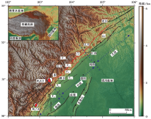
图 1 龙门山断裂带主要断裂及地震分布图
黑色实线为主要断裂分布, 虚线为隐伏断裂, 红色实线为2008年汶川地震同震地表破裂带。
F1 汶川-茂汶断裂带; F2 北川-映秀断裂带; F3 彭灌断裂带; F4 关口隐伏断裂; F5 彭县隐伏断裂; F6 大邑隐伏断裂
Fig. 1 The major fault system and earthquake distribution in the Longmen Shan thrust belt.

2008年汶川地震期间, 该断裂附近出现了地表褶皱、 地裂缝(杨晓平等, 2009), 并出现了大量砂土液化和喷砂冒水等现象(刘保金等, 2009; Liu-Zeng et al., 2017), 这些现象被认为与彭县隐伏断裂的活动密切相关。 彭县隐伏活动断裂位于成都平原地区, 该区人口和工业相对比较密集。 揭示该断层在地下的三维构造特征, 可为研究区的潜在地震风险性评估及地震灾害研究提供重要依据。

彭县断裂带覆盖了几百米厚的新生代地层(李勇等, 2006)。 先前对该地下隐伏构造的研究主要借助于二维人工地震反射剖面。 此前有观点认为彭县隐伏断裂为切穿基底的高陡逆冲断层(刘树根等, 2009; 颜丹平等, 2010); 也有学者认为彭县隐伏断裂下部为基底卷入逆冲断层, 上部为褶皱陡坎(Jia et al., 2010; Li et al., 2013); 另一种观点认为彭县隐伏断裂是发育在中下三叠统滑脱层之上的逆断层(刘保金等, 2009; 鲁人齐等, 2010)。 此外, 前人研究认为其与龙门山南段的大邑隐伏断裂或前缘盲冲断层(range frontal thrust fault)相连(Wang et al., 2014; Li et al., 2016), 可发生7级左右的大地震(Li et al., 2017)。 因此, 深入研究彭县隐伏活动断裂的三维结构和特征, 分析其生长走向及其与龙门山南段山前隐伏断裂是否有效连接, 对龙门山山前带的地震危险性评估至关重要。

本研究使用高精度三维地震资料以及钻井数据, 构建精细的彭县断裂地下三维模型。 通过抽取多条研究区三维地震反射剖面, 运用断层相关褶皱和褶皱调节断层理论(Suppe, 1983; Mitra, 2002; Shaw et al., 2005)分析彭县隐伏构造的地下结构, 研究断层的几何学特征; 联合多条剖面进行解释, 建立彭县断层的三维几何结构, 再根据三维断层模型分析其地下空间展布形态及规模。 研究结果进一步明确了彭县隐伏断裂的三维构造特征, 并对其形成机制进行了探讨。

1 区域地质背景

龙门山位于青藏高原东缘与四川盆地交界的位置, 是由龙门山断裂带和川西前陆盆地组成的一个地质体。 龙门山北起广元, 南至鲜水河断裂, 总长约500km, 宽30~60km, 呈NE向展布, 是中国最典型的逆冲推覆构造带之一(邓起东等, 1994; 张培震等, 2003; 刘树根等, 2008)。 龙门山构造样式复杂多样, 发育多条断裂带(图1), 如青川-茂汶断裂(F1)、 北川-映秀断裂(F2)、 彭灌断裂(F3)、 关口隐伏断裂(F4)及彭县隐伏断裂(PXF)等。 由于新生代青藏高原的持续挤压作用, 使得构造变形持续向E扩展并进入川西前陆盆地(曾允孚等, 1995; 贾东等, 2003)。

龙门山构造带是在前震旦纪结晶基底上发育起来的, 经历了古生代被动大陆边缘裂陷阶段以及中生代以来的推覆造山阶段(陈社发等, 1994; Burchfiel et al., 1995)。 从震旦纪到中三叠世, 川西及龙门山地区受被动大陆边缘控制, 发育巨厚的海相碳酸盐沉积。 在晚三叠世, 龙门山及其西侧的沉积环境发生改变, 龙门山大规模地向SE推覆, 形成了一系列冲断带和川西前陆盆地, 并且在盆地中充填了巨厚的陆相碎屑岩和砾岩(贾东等, 2003)。 从晚白垩世至今, 龙门山地区构造动力发生改变, 再次逆冲推覆造山, 山前盆地的地层形态由其控制, 堆积了大量新生代陆源碎屑沉积物(刘树根等, 2003; 陈竹新等, 2005, 2008; 李忠权等, 2011)。

龙门山构造带沿走向以北川— 安县与卧龙— 怀远一线为界被分为3段, 即北段、 中段和南段。 中段的典型特征是出露了彭灌基底杂岩及前缘发育飞来峰(李勇等, 2000; 金文正等, 2007)。 在垂直于走向的方向上, 前人通过断裂的长度、 产状和分布位置将龙门山划分为5个构造带(李智武等, 2008)。 其中, 安县-灌县-双石断裂以东的区域为川西前陆盆地(刘树根等, 1995; 翟光明等, 2002), 本研究区主要位于龙门山中段山前的川西盆地内。

2 彭县断裂地震构造解释
2.1 彭县断裂边界的界定

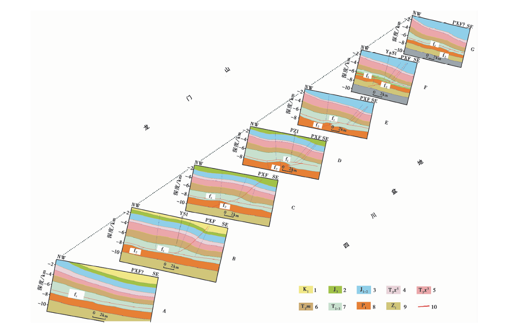
根据川西地区的钻井分层资料, 在地震剖面上一共识别出8个主要的地震反射界面(图3), 底部为下震旦统底界(Z1), 最上是下白垩统底界(K1), 主要发育中生代地层, 解释的层位包括中二叠统底界(P2)、 上三叠统马鞍塘组一段底界(T3m1)、 上三叠统须家河组三段底界(T3x3)、 上三叠统须家河组五段底界(T3x5)、 下侏罗统千佛岩组底界(J1q)和上侏罗统蓬莱镇组底界(J3p)。 根据前人利用声波测井(Wang et al., 2016)和地震叠加速度(刘保金等, 2009)得到的速度结构, 我们选取该区域的平均速度4.6km/s进行剖面的时深转换(Jia et al., 2010)。

地震反射剖面A位于崇州市北部(图2)。 通过未解释的地震剖面(图3a)可以发现地层整体略微向SE倾。 剖面反射特征明显, 波组连续, 且没有被断层错动的痕迹, 故认为该剖面为彭县隐伏断裂(PXF)的南边界, 同时其与南部的大邑隐伏断裂还有一定距离, 因此两者并不属于同一条断裂。 综合解释后发现(图3b), 下二叠统(P1)和震旦系(Z)之间的地层较为平坦连续, 上三叠统(T3m)和中二叠统(P2)之间的地层厚度发生变化, 北西部分比南东厚, 而上三叠统(T3m)之上的地层厚度一致。 前人的研究表明, 下三叠统嘉陵江组上部发育的一套膏岩层为重要滑脱层, 该滑脱层一直延伸至龙泉山(汤良杰, 2008; 鲁人齐等, 2010)。 初步分析认为可能是由于该套滑脱层f1之上存在构造变形导致地层增厚。

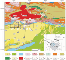
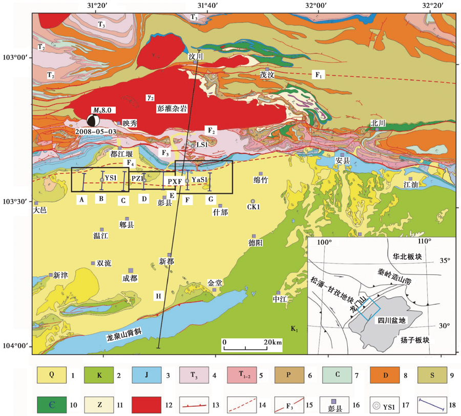
图 2 龙门山断裂带区域地质背景及研究区人工地震分布图
从3个不同的三维地震工区抽取地震剖面A— G。 1 新生界; 2 白垩系; 3 侏罗系; 4 上三叠系; 5 中下三叠系; 6 二叠系; 7 石炭系; 8 泥盆系; 9 志留系; 10 寒武系; 11 震旦系; 12 杂岩体; 13 主要断层; 14 隐伏断裂; 15 断层名; 16 地名; 17 钻井位置; 18 地震反射剖面
Fig. 2 Local geological map in the Longmen Shan thrust belt.

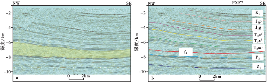
图 3 龙门山中段彭县地震反射剖面A地质构造解释Fig. 3 Geological and structural interpretation of the seismic reflection profile A.

地震反射剖面G位于什邡市西南(图2), 通过解释剖面(图4b)发现中新生代地层为背斜构造, 波阻特征明显, 在彭县隐伏断裂(PXF)可能出现膝折带的位置反射同相轴连续, 故认为断裂在该剖面处已经终止。 二叠系及震旦系反射轴面出现错断, 可能为早期形成的断层f2被中下三叠统滑脱层f1所截断。

图 4 龙门山中段彭县地震反射剖面G地质构造解释Fig. 4 Geological and structural interpretation of the seismic reflection profile G.

2.2 彭县断裂的几何结构

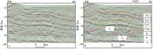
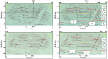
地震反射剖面B过YS1井(图2, 图5a, b), 其主要地层界面反射波组特征明显, 通过轴面分析及断点识别可清晰地判断出彭县隐伏断裂的位置。 剖面上、 下部二叠系及震旦系的反射波组连续, NW方向局部发育小断裂f2切穿中二叠统(P2)并与滑脱层f1相交。 彭县隐伏断裂向上切穿侏罗系和白垩系, 并进入新生界。

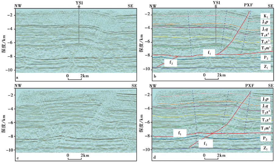
图 5 龙门山中段彭县隐伏断裂区地震反射剖面B和C及其解释
a、 b分别为剖面B未解释和解释图; c、 d分别为剖面C未解释和解释图。 蓝色虚线表示褶皱转折轴面
Fig. 5 Geological and structural interpretation of the seismic reflection profile B and C.

通过解释地震反射剖面C发现彭县埋藏构造为一明显的宽缓背斜(图5c, d), 前翼倾角比后翼稍大, 轴面和断点位置显示彭县隐伏断裂位于褶皱膝折带。 NW方向的中二叠统之下有一个逆断层f2, 发育小型的背斜构造。 在中下三叠统发育滑脱层f1, 滑脱层与地层平行展布, 一直向E延伸。 下三叠统在NW方向有明显的加厚现象, 在断层下盘, 上三叠统内发育断层相关褶皱。 因此, 彭县隐伏断裂是发育在滑脱层f1之上的逆断层, 其倾角约55° 。

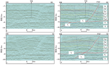
地震反射剖面D横跨PZ1井(图2, 图6a), 深部中二叠统(P2)地震波轴面错断十分明显, 向上与滑脱层f1会合, 并在上盘形成背斜构造。 滑脱层f1表现出断坪— 断坡— 断坪的几何样式(图6b)。 上部背斜的后翼倾角与f1的断坡角十分接近, 是典型的断层转折褶皱。 彭县断裂发育在褶皱膝折带的位置, 波组特征显示为空白反射。

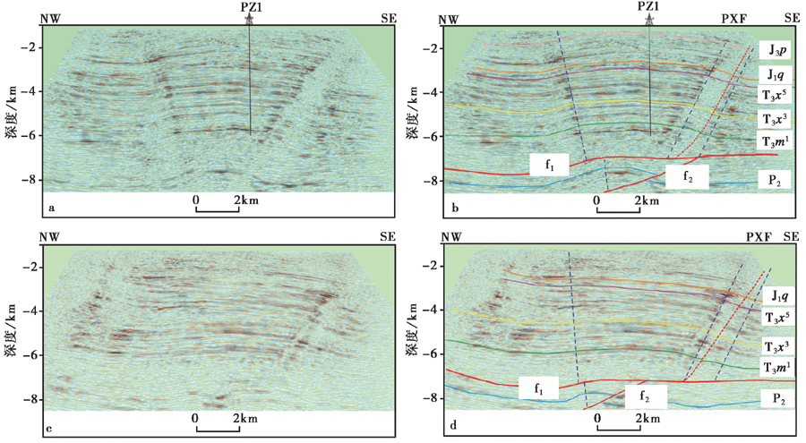
图 6 龙门山中段彭县隐伏断裂区地震反射剖面D和E
a、 b分别为剖面D未解释和解释图; c、 d分别为剖面E未解释和解释图
Fig. 6 Geological and structural interpretation of the seismic reflection profile D and E.

通过解释地震反射剖面E发现, 其构造特征与剖面D相似, f1为滑脱层, 在其下的二叠系中还发育逆断层f2, 形成背斜褶皱。 滑脱层上部的沉积构造为宽缓背斜, 彭县隐伏断裂应该位于膝折带的位置, 但地震反射剖面特征不明显。 通过断层之间的交切关系可将彭县地区构造的形成细分为3个阶段, 第一阶段为逆断层f2的形成, 第二阶段为滑脱层f1活动形成背斜, 第三阶段为彭县隐伏断裂形成。

3 彭县断裂的空间三维展布

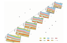
通过上述7条人工地震反射剖面的解释, 本研究建立了龙门山山前彭县隐伏活动断裂的三维模型(图7), 更加直观地展示了断裂在地下的几何结构和特征。 彭县隐伏断裂与上盘褶皱轴的走向一致, 均为NE-SW向; 断裂规模较小, 从图 4可以看出破裂延伸距离比褶皱轴短。 新生代以来, 龙门山中段的逆冲推覆导致上地壳的快速隆升和缩短(贾东等, 2003; Hubbard et al., 2009; Lu et al., 2014)。 彭县隐伏构造是在龙门山向SE方向推挤过程中形成的, 它体现了龙门山大规模推覆运动的细节, 滑脱层f1持续向E延伸一直到龙泉山背斜。

图 7 龙门山山前彭县隐伏活动断层(PXF) 三维几何结构图
1白垩系; 2上侏罗统; 3中下侏罗统; 4上三叠统须家河组五段; 5上三叠统须家河组三段; 6上三叠统马鞍塘组; 7中下三叠统; 8下二叠统; 9下古生界与基底; 10主要断层
研究区的三维人工地震数据能有效覆盖彭县隐伏断裂(图8a)。 为了使断层沿走向的变化特征更加明显, 我们将7条地震剖面加密至22条, 分别对每一条剖面进行断层的识别和精细刻画(图8b); 通过解译断层迹线和节点的控制, 根据三角网格构建了初步的三维断裂模型(图8c); 并在此基础上分析彭县隐伏断裂三维空间中的倾角变化特征(图8d)。 总体来看, 彭县隐伏断裂总长近50km, 断裂总体产状相似, 下切垂直深度约8km, 倾角主体为高角度60° ~65° 。 计算获得其三维断裂面积约450km2
Fig. 7 Simplified 3-D geometry of Pengxian blind fault (PXF) structure in central Lms front belt

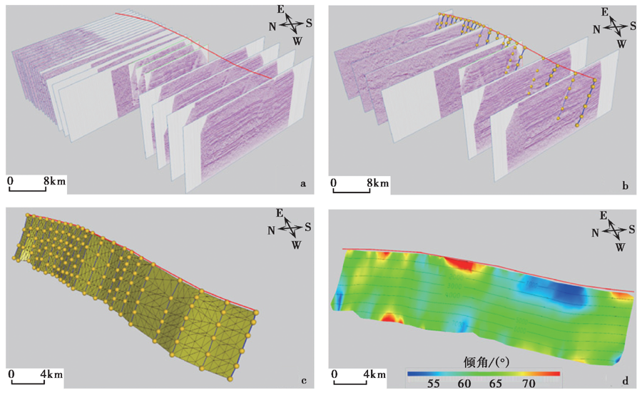
图 8 龙门山中段山前彭县隐伏断裂三维模型
红色实线为彭县断裂浅表投影展布; b、 c纵向上的深色线条为剖面解释断层迹线, 黄色圆点为控制节点。
c 黄色三维断层面显示三角网格结构; d 深度等值线(单位: m)及断层面的倾角变化特征
Fig. 8 Three-dimensional model of Pengxian blind fault(PXF)structure in central LMS front belt.

4 讨论与结论
4.1 断裂的形成机制及其运动学

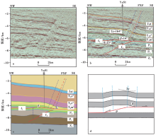
地震反射剖面F经过YaS1井(图2, 图9)。 剖面显示古生代和中生代之间存在褶皱变形, 在NW-SE方向, 上三叠统和下二叠统厚度减薄。 下二叠统和下震旦统之间的古生代地层厚度也发生了变化, 根据轴面分析是由于逆冲断层f2所致, 且f2穿过了下二叠统, 与滑脱层f1会合。 位于中下三叠统的滑脱层f1导致了地层的重复和增厚, 其滑移量约3.4km。 在该剖面, 彭县隐伏断裂的地震反射特征不明显, 断层大致位于褶皱翼部的空白反射区。

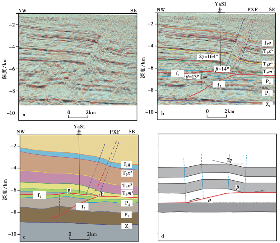
图 9 龙门山中段彭县隐伏断裂区地震反射剖面F的地质构造解释
a 未解释剖面; b 地震反射剖面F的地质构造解释; c 地震反射剖面的几何结构模型; d 断层f1转折褶皱模型。
图c中点g、 h之间的间距为沿滑脱层f1的滑动距离
Fig. 9 Geological and structural interpretation of the seismic reflection profile F.

剖面中的背斜轴面倾向NW, 前翼倾角为14° , 断坡倾角为13° , 褶皱翼间角为164° (图9b)。 断层转折褶皱中, 断层转折角(φ )、 断层面的切角(θ )、 背斜前翼翼间角的半值(γ )和上盘断坡切角(β )满足以下方程(Suppe, 1983):

φ=tan-1sin(γ-θ)sin(2γ-θ)-sinθcos(γ-θ)sin(2γ-θ)-sinθ-sinγ(1)

β=θ-φ+(180°-2γ)(2)

根据式(1)和式(2), 当θ =13° 、 γ =82° 时, 求得φ =15.1° , β =13.8° 。 实际测量结果与理论值基本吻合, 故该背斜为滑脱层f1上的断层转折褶皱。 因此, 中二叠统(P2)与下三叠统(T3m)之间的地层增厚是由于塑性体的内部在滑脱层断坡之上发生了加厚作用所致。

高精度三维人工地震剖面非常清楚地展示了彭县的地下几何结构, 对研究断裂和褶皱的相互关系提供了重要的数据支撑。 解释结果认为f1是一条横跨川西前陆盆地的滑脱层, f2是发育更早的逆冲断裂, 彭县隐伏背斜为发育在滑脱层f1之上的断层转折褶皱; 彭县隐伏断裂则发育在褶皱前翼膝折带的位置。 断裂与该处褶皱轴的走向一致, 均为NE-SW向, 且断裂规模较小, 破裂延伸距离比褶皱轴短(图8), 很明显从属于彭县隐伏背斜。 此外, 地震剖面上显示彭县隐伏断层的断距很小, 断层面上、 下地层变化不明显(图5, 图6), 结合褶皱相关断层理论(Mitra, 2002; 邓洪菱等, 2009), 我们认为彭县隐伏断裂符合褶皱调节性断层的特征。

此外, 研究表明2013年四川芦山发生的MS7.0地震是由隐伏活动断裂所引起的(李勇等, 2013; 徐锡伟等, 2013; Li et al., 2014; 鲁人齐等, 2017)。 龙门山山前存在多条隐伏活动断裂, 前人研究发现其晚第四纪以来有过一定活动(董绍鹏等, 2008; 刘保金等, 2009; 杨晓平等, 2009), 表明这些隐伏活动断裂具有一定的地震危险性。 但从其形成机制分析, 由于彭县隐伏断裂为褶皱调节性断层, 一般以褶皱活动缩短变形为主, 与龙门山主要断裂带有所区别, 断裂整体规模也有限, 因此我们认为其发生破坏性大地震的可能性较低。

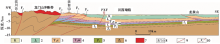
前人研究提出了龙门山和四川盆地上地壳变形的结构模型(Jia et al., 2010; Li et al., 2016; Lu et al., 2016)。 在新生代晚期, 大规模逆冲导致龙门山的快速隆升和缩短, 发育在中下三叠统的滑脱层f1控制了龙门山及四川盆地浅部的构造变形(Jia et al., 2006; Hubbard et al., 2009)。 龙泉山背斜是川西盆地内一条长约200km的背斜构造带(图1, 图10), 作为青藏高原东缘的边界, 其响应了青藏高原东缘向四川盆地的生长过程。 龙泉山背斜的变形与滑脱层f1密切相关(Jia et al., 2010)。 已有研究表明龙泉山背斜的主要变形时间在晚中新世(11~15MaiBP)(Richardson et al., 2008), 其主断层的滑移量约3km(Li et al., 2015; Lu et al., 2018)。

图 10 彭县断裂在龙门山断裂带中段及川西坳陷的位置示意图(据Lu et al., 2018改)
1 白垩系; 2 上侏罗统; 3 上三叠统须家河组; 4 上三叠统马鞍塘组; 5 下二叠统; 6 下古生界与基底; 7 彭灌杂岩; 8 地名; 9 主要断层; 10 断层名。 断裂编号所代表的断裂名称与图 1相同
Fig. 10 Location illustration of Pengxian Fault(PXF)in the central LMS and western SCB(after Lu et al., 2018).

彭县隐伏构造揭示了龙门山沿SE的生长过程, 在彭县背斜处f1的滑移量3.5~4.0km(图9), 其初始形成时间应该比龙泉山背斜更早(邓起东等, 1994; Li et al., 2015)。 通过计算, 发现滑脱层f1在彭县背斜处的滑移速率为0.23~0.36mm/a, 在龙泉山背斜处为0.2~0.27mm/a(Lu et al., 2018), 这与青藏高原东缘大致的缩短率1~3mm/a相比非常小(Shen et al., 2005; Hubbard et al., 2009; Li et al., 2016), 表明川西盆地对龙门山冲断带缩短量的贡献十分有限, 体现了四川盆地的阻挡效应。

4.2 结论

(1)彭县隐伏活动断裂是在浅层盖层里发育的一条高角度(50° ~60° )逆冲断层, 断裂走向NE-SW, 倾向NW, 长约50km, 下切深度约8km, 三维断层结构显示其面积约450km2

(2)彭县隐伏背斜是发育在中下三叠统滑脱层f1上的低角度断层转折褶皱; 彭县隐伏断裂则是发育在该褶皱前翼的一条褶皱调节性断层。

(3)褶皱、 断裂与沉积的相互关系是构造解释中重要的一环; 断层相关褶皱与褶皱调节断层理论的综合运用, 对研究活动构造变形及断层的几何学、 运动学特征, 建立断层的三维模型具有重要意义。

致谢 审稿专家为本文提出了宝贵的修改意见, 让笔者获益良多, 对文章质量的提升帮助很大, 在此表示衷心感谢!

参考文献
[1] 陈社发, 邓起东, 赵小麟, . 1994. 龙门山中段推覆构造带及相关构造的演化历史和变形机制[J]. 地震地质, 16(4): 404421.
CHEN She-fa, DENG Qi-dong, ZHAO Xiao-lin, et al. 1994. The evolution and deformation mechanism of the related structures of the middle section of the Longmen Shan thrust belt[J]. Seismology and Geology, 16(4): 404421(in Chinese). [本文引用:1]
[2] 陈竹新, 贾东, 魏国齐, . 2008. 川西前陆盆地中-新生代沉积迁移与构造转换[J]. 中国地质, 35(3): 472481.
CHEN Zhu-xin, JIA Dong, WEI Guo-qi, et al. 2008. Meso-Cenozoic sediment transport and tectonic transition in the western Sichuan foreland basin[J]. Geology in China, 35(3): 472481(in Chinese). [本文引用:1]
[3] 陈竹新, 贾东, 张惬, . 2005. 龙门山前陆褶皱冲断带的平衡剖面分析[J]. 地质学报, 79(1): 3845.
CHEN Zhu-xin, JIA Dong, ZHANG Qie, et al. 2005. Balanced cross section analysis of the fold-thrust belt of the Longmen Mountains[J]. Acta Geologica Sinica, 79(1): 3845(in Chinese). [本文引用:1]
[4] 邓洪菱, 张长厚, 李海龙, . 2009. 褶皱相关断裂构造及其地质意义[J]. 自然科学进展, 19(3): 285296.
DENG Hong-ling, ZHANG Chang-hou, LI Hai-long, et al. 2009. Fold-accommodation faults and its implications[J]. Progress in Natural Science, 19(3): 285296(in Chinese). [本文引用:1]
[5] 邓起东, 陈社发, 赵小麟. 1994. 龙门山及其邻区的构造和地震活动及动力学[J]. 地震地质, 16(4): 389403.
DENG Qi-dong, CHEN She-fa, ZHAO Xiao-lin. 1994. Tectonics, seismicity and dynamics of Longmenshan Mountains and its adjacent regions[J]. Seismology and Geology, 16(4): 389403(in Chinese). [本文引用:2]
[6] 董绍鹏, 韩竹军, 尹金辉, . 2008. 龙门山山前大邑断裂活动时代与最新构造变形样式初步研究[J]. 地震地质, 30(4): 9961003.
DONG Shao-peng, HAN Zhu-jun, YIN Jin-hui, et al. 2008. A preliminary research on the latest tectonic deformation style and the activity age of the Dayi Fault in the piedmont of the Longmen Mountains[J]. Seismology and Geology, 30(4): 9961003(in Chinese). [本文引用:1]
[7] 贾东, 陈竹新, 贾承造, . 2003. 龙门山前陆褶皱冲断带构造解析与川西前陆盆地的发育[J]. 高校地质学报, 9(3): 402410.
JIA Dong, CHEN Zhu-xin, JIA Cheng-zao, et al. 2003. Structural features of the Longmen Shan fold and thrust belt and development of the western Sichuan foreland basin, central China[J]. Geological Journal of China Universities, 9(3): 402410(in Chinese). [本文引用:3]
[8] 金文正, 汤良杰, 杨克明, . 2007. 川西龙门山褶皱冲断带分带性变形特征[J]. 地质学报, 81(8): 10721080.
JIN Wen-zheng, TANG Liang-jie, YANG Ke-ming, et al. 2007. Deformation and zonation of the Longmenshan fold and thrust zone in the western Sichuan Basin[J]. Acta Geologica Sinica, 81(8): 10721080(in Chinese). [本文引用:1]
[9] 李勇, 孙爱珍. 2000. 龙门山造山带构造地层学研究[J]. 地层学杂志, 24(3): 201206.
LI Yong, SUN Ai-zhen. 2000. Tectostratigraphy of Longmenshan orogen[J]. Journal of Stratigraphy, 24(3): 201206(in Chinese). [本文引用:1]
[10] 李勇, 周荣军, Densmore A L, . 2006. 青藏高原东缘龙门山晚新生代走滑挤压作用的沉积响应[J]. 沉积学报, 24(2): 153164.
LI Yong, ZHOU Rong-jun, Densmore A L, et al. 2006. Sedimentary responses to Late Cenozoic thrusting and strike-slipping of Longmen Shan along eastern margin of Tibetan plateau[J]. Acta Sedimentologica Sinica, 24(2): 153164(in Chinese). [本文引用:1]
[11] 李勇, 周荣军, 赵国华, . 2013. 龙门山前缘的芦山地震与逆冲滑脱褶皱作用[J]. 成都理工大学学报(自然科学版), 40(4): 353363.
LI Yong, ZHOU Rong-jun, ZHAO Guo-hua, et al. 2013. Thrusting and detachment folding of Lushan earthquake in front of Longmenshan Mountains[J]. Journal of Chengdu University of Technology(Science and Technology Edition), 40(4): 353363(in Chinese). [本文引用:1]
[12] 李智武, 刘树根, 陈洪德, . 2008. 龙门山冲断带分段-分带性构造格局及其差异变形特征[J]. 成都理工大学学报(自然科学版), 35(4): 440454.
LI Zhi-wu, LIU Shu-gen, CHEN Hong-de, et al. 2008. Structural segmentation and zonation and differential deformation across and along the Lomgmen thrust belt, west Sichuan, China[J]. Journal of Chengdu University of Technology(Science and Technology Edition), 35(4): 440454(in Chinese). [本文引用:1]
[13] 李忠权, 应丹琳, 李洪奎, . 2011. 川西盆地演化及盆地叠合特征研究[J]. 岩石学报, 27(8): 23622370.
LI Zhong-quan, YING Dan-lin, LI Hong-kui, et al. 2011. Evolution of the western Sichuan Basin and its superimposed characteristics, China[J]. Acta Petrologica Sinica, 27(8): 23622370(in Chinese). [本文引用:1]
[14] 刘保金, 张先康, 酆少英, . 2009. 龙门山山前彭州隐伏断裂高分辨率地震反射剖面[J]. 地球物理学报, 52(2): 538546.
LIU Bao-jin, ZHANG Xian-kang, FENG Shao-ying, et al. 2009. High-resolution seismic reflection profile across Pengzhou buried fault in the frontal areas of Longmen Shan[J]. Chinese Journal of Geophysics, 52(2): 538546(in Chinese). [本文引用:4]
[15] 刘树根, 李智武, 曹俊兴, . 2009. 龙门山陆内复合造山带的四维结构构造特征[J]. 地质科学, 44(4): 11511180.
LIU Shu-gen, LI Zhi-wu, CAO Jun-xing, et al. 2009. 4-D textural and structural characteristics of Longmen intracontinental composite orogenic belt, Southwest China[J]. Chinese Journal of Geology, 44(4): 11511180(in Chinese). [本文引用:1]
[16] 刘树根, 罗志立, 戴苏兰, . 1995. 龙门山冲断带的隆升和川西前陆盆地的沉降[J]. 地质学报, 69(3): 204214.
LIU Shu-gen, LUO Zhi-li, DAI Su-lan, et al. 1995. The uplift of Longmenshan thrust belt and subsidence of the western Sichuan foreland basin[J]. Acta Geologica Sinica, 69(3): 204214(in Chinese). [本文引用:1]
[17] 刘树根, 罗志立, 赵锡奎, . 2003. 中国西部盆山系统的耦合关系及其动力学模式: 以龙门山造山带-川西前陆盆地系统为例[J]. 地质学报, 77(2): 177186.
LIU Shu-gen, LUO Zhi-li, ZHAO Xi-kui, et al. 2003. Coupling relationships of sedimentary basin: Orogenic belt systems and their dynamic models in West China[J]. Acta Geologica Sinica, 77(2): 177186(in Chinese). [本文引用:1]
[18] 刘树根, 田小彬, 李智武, . 2008. 龙门山中段构造特征与汶川地震[J]. 成都理工大学学报(自然科学版), 35(4): 388397.
LIU Shu-gen, TIAN Xiao-bin, LI Zhi-wu, et al. 2008. Structural features of the central Longmen Mountains and the Wenchuan earthquake in Sichuan, China[J]. Journal of Chengdu Institute of Technology(Science and Technology Edition), 35(4): 388397(in Chinese). [本文引用:1]
[19] 鲁人齐, 何登发, Suppe J, . 2010. 龙门山中段山前带浅层冲断系统的结构、 形成与演化[J]. 地质科学, 45(4): 9971010.
LU Ren-qi, HE Deng-fa, Suppe J, et al. 2010. The structures, formation and evolution of the shallow thrusting system in the central Longmen Mountains front belt[J]. Chinese Journal of Geology, 45(4): 9971010(in Chinese). [本文引用:2]
[20] 鲁人齐, 徐锡伟, 何登发, . 2017. 龙门山南段芦山震区浅层沉积与构造变形: 对深部发震构造的约束[J]. 地球物理学报, 60(8): 29242934.
LU Ren-qi, XU Xi-wei, HE Deng-fa, et al. 2017. The shallow sedimentary and structural deformation in the southern Longmen Shan: Constraints on the seismotectonics of the 2013 Lushan MW6. 7 earthquake[J]. Chinese Journal of Geophysics, 60(8): 29242934(in Chinese). [本文引用:1]
[21] 汤良杰, 杨克明, 金文正, . 2008. 龙门山冲断带多层次滑脱带与滑脱构造变形[J]. 中国科学(D辑), 38(S1): 3040.
TANG Liang-jie, YANG Ke-ming, JIN Wen-zheng, et al. 2008. Multi-level decollement zones and detachment deformation of Longmenshan thrust belt, Sichuan Basin, Southwest China[J]. Science in China(Ser D), 38(S1): 3040. [本文引用:1]
[22] 徐锡伟, 闻学泽, 韩竹军, . 2013. 四川芦山7. 0级强震: 一次典型的盲逆断层型地震[J]. 科学通报, 58(20): 18871893.
XU Xi-wei, WEN Xue-ze, HAN Zhu-jun, et al. 2013. Lushan MS7. 0 earthquake: A blind reserve-fault earthquake[J]. Chinese Science Bulletin, 58(20): 18871893(in Chinese). [本文引用:1]
[23] 颜丹平, 李书兵, 曹文涛, . 2010. 龙门山多层分层拆离地壳结构: 新构造变形与深部构造证据[J]. 地学前缘, 17(5): 106116.
YAN Dan-ping, LI Shu-bing, CAO Wen-tao, et al. 2010. Multi-layer detachment crustal structure in the Longmen Mountains: Evidences from neotectonic deformation and geophysical data[J]. Earth Science Frontiers, 17(5): 106116(in Chinese). [本文引用:1]
[24] 杨晓平, 李安, 刘保金, . 2009. 成都平原内汶川 MS8. 0地震的地表变形[J]. 地球物理学报, 52(10): 25272537.
YANG Xiao-ping, LI An, LIU Bao-jin, et al. 2009. Surface deformation in the Chengdu plain area produced by the Wenchuan MS8. 0 earthquake of 12 May 2008, Sichuan, China[J]. Chinese Journal of Geophysics, 52(10): 25272537(in Chinese). [本文引用:2]
[25] 曾允孚, 李勇. 1995. 龙门山前陆盆地形成与演化[J]. 矿物岩石, 15(1): 4049.
ZENG Yun-fu, LI Yong. 1995. The formation and evolution of Longmen Mountains foreland basin[J]. Journal of Mineralogy and Petrology, 15(1): 4049(in Chinese). [本文引用:1]
[26] 翟光明, 何文渊. 2002. 中国前陆盆地特点及未来油气勘探策略[G]∥中国石油勘探与生产分公司编. 中国中西部前陆盆地冲断带油气勘探文集. 北京: 石油工业出版社: 1522.
ZHAI Guang-ming, HE Wen-yuan, 2002. The characteristics and the future oil and gas exploration strategy of China foreland basin[G]∥China Petroleum Exploration and Production Branch Code(ed). Collection of Oil and Gas Exploration on Thrust Belt of the Foreland Basin. Petroleum Industry Press, Beijing. 1522(in Chinese). [本文引用:1]
[27] 张培震, 邓起东, 张国民, . 2003. 中国大陆的强震活动与活动地块[J]. 中国科学(D辑), 33(S1): 1220.
ZHANG Pei-zhen, DENG Qi-dong, ZHANG Guo-ming, et al. 2003. Active tectonic blocks and strong earthquakes in the continental of China[J]. Science in China(Ser D), 33(S1): 1220(in Chinese). [本文引用:1]
[28] Burchfiel B C, Chen Z, Liu Y, et al. 1995. Tectonics of the Longmen Shan and adjacent regions, central China[J]. International Geology Review, 37(8): 661735. [本文引用:1]
[29] Hubbard J, Shaw J H. 2009. Uplift of the LMS and Tibetan plateau, and the 2008 Wenchuan( M=7. 9)earthquake[J]. Nature, 458(7235): 194197. [本文引用:3]
[30] Jia D, Li Y, Lin A, et al. 2010. Structural model of 2008 MW7. 9 Wenchuan earthquake in the rejuvenated Longmen Shan thrust belt, China[J]. Tectonophysics, 491(1): 174184. [本文引用:4]
[31] Jia D, Wei G Q, Chen Z X, et al. 2006. Longmen Shan fold-thrust belt and its relation to western Sichuan Basin in central China: New insights from hydrocarbon exploration[J]. American Association of Petroleum Geologists Bulletin, 90: 14251447. [本文引用:1]
[32] Liu-Zeng J, Wang P, Zhang Z, et al. 2017. Liquefaction in western Sichuan Basin during the 2008 MW7. 9 Wenchuan earthquake, China[J]. Tectonophysics, 694: 214238. [本文引用:1]
[33] Li K, Xu X W, Tan X B, et al. 2015. Late Quaternary deformation of the Longquan anticline in the Longmenshan thrust belt, eastern Tibet, and its tectonic implication[J]. Journal of Asian Earth Sciences, 112: 110. [本文引用:2]
[34] Li Y, Jia D, Wang M, et al. 2014. Structural geometry of the source region for the 2013 MW6. 6 Lushan earthquake, implication for earthquake hazard assessment along the Longmen Shan[J]. Earth and Planetary Science Letters, 390: 275286. [本文引用:1]
[35] Li Z G, Jia D, Chen W. 2013. Structural geometry and deformation mechanism of the Longquan anticline in the Longmen Shan fold-and -thrust belt, eastern Tibet[J]. Journal of Asian Earth Sciences, 63: 223234. [本文引用:1]
[36] Li Z G, Jing L Z, Jia D, et al. 2016. Quaternary activity of the range front thrust system in the Longmen Shan piedmont, China, revealed by seismic imaging and growth strata[J]. Tectonics, 35(12): 28072827. [本文引用:3]
[37] Li Z G, Jing L Z, Rafael Almeida, et al. 2017. Re-evaluating seismic hazard along the southern Longmen Shan, China: Insights from the 1970 Dayi and 2013 Lushan earthquakes[J]. Tectonophysics, 717: 513530. [本文引用:1]
[38] Lu R Q, He D F, John S, et al. 2014. Structural model of the central Longmen Shan thrusts using seismic reflection profiles: Implications for the sediments and deformations since the Mesozoic[J]. Tectonophysics, 630: 4353. [本文引用:1]
[39] Lu R Q, He D F, Xu X W, et al. 2016. Crustal-scale tectonic wedging in the central Longmen Shan: Constraints on the uplift mechanism in the southeastern margin of Tibetan plateau[J]. Journal of Asian Earth Sciences, 117: 7381. [本文引用:1]
[40] Lu R Q, He D F, Xu X W, et al. 2018. Geometry and kinematics of buried structures in the piedmont of the central Longmen Shan: Implication for the growth of the eastern Tibetan plateau[J]. Journal of the Geological Society, 176(2): 323333. [本文引用:2]
[41] Mitra S. 2002. Fold-accommodation faults[J]. American Association of Petroleum Geologists Bulletin, 86: 671693. [本文引用:2]
[42] Richardson N J, Densmore A L, Seward D, et al. 2008. Extraordinary denudation in the Sichuan Basin: Insights from low-temperature thermochronology adjacent to the eastern margin of the Tibetan plateau[J]. Journal of Geophysical Research, 113(B4): B04409. [本文引用:1]
[43] Shaw J H, Connors C, Suppe J. 2005. Seismic Interpretation of Contractional Fault-related Folds: An AAPG Seismic Atlas[M]. American Association of Petroleum Geologists Studies in Geology 53: 157. [本文引用:1]
[44] Shen Z K, Lu J N, Wang M, et al. 2005. Contemporary crustal deformation around the southeast borderland of the Tibetan plateau[J]. Journal of Geophysical Research, 110: B11409. [本文引用:1]
[45] Suppe J. 1983. Geometry and kinematics of fault-bend folding[J]. American Journal of Science, 283(7): 684721. [本文引用:2]
[46] Wang M M, Hubbard J, Plesch A, et al. 2016. Three-dimensional seismic velocity structure in the Sichuan Basin, China[J]. Journal of Geophysical Research: Solid Earth, 121: 10071022. [本文引用:1]
[47] Wang M M, Jia D, Shaw J H, et al. 2014. The 2013 Lushan earthquake: Implications for seismic hazards posed by the range front blind thrust in the Sichuan Basin, China[J]. Geology, 42(10): 915918. [本文引用:1]