
雅鲁藏布江断裂带昂仁段晚第四纪活动证据
[李彦宝1  , 陈立春
, 陈立春2, 1, * , 王虎3 , 曾蒂4 , 刘成龙1 ]
, 陈立春, 王虎|
|


〔作者简介〕 李彦宝, 男, 1981年生, 2013年于中国地震局地质研究所获构造地质学专业博士学位, 助理研究员, 现主要从事活动构造、 古地震与地震中长期预测方面的工作, E-mail: liyanbao@ies.ac.cn。
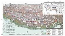
雅鲁藏布江断裂带是青藏高原南部一条规模巨大的近EW向大地构造边界, 其经历了长期的构造演化, 一直是地学界关注的热点。 已有资料大多认为青藏高原南部地区现今的构造活动以近SN向的裂谷系为主, 近EW向的雅鲁藏布江断裂带仅在东构造结部位的鲁朗一带发现有全新世活动的迹象, 而米林以西段的最新活动主要发生在早、 中更新世。 近年来, 在沿该断裂带日喀则以西段的调查过程中, 在昂仁错一带发现多个断层断错晚第四纪地层的剖面, 显示其晚第四纪以来仍有断错地表的活动, 但活动遗迹延伸较短。 综合分析认为, 在区域SN向裂谷的构造环境中, 被裂谷系分割的近EW向雅鲁藏布江断裂带可能具次级构造调节作用, 从而表现出相对较弱或局部的断错地表活动。
The Yarlung Tsangbo fault zone, one of the most important geological interfaces in the Yarlung Tsangbo suture zone which is a huge geotectonic boundary with nearly east-west-trending in southern Tibet Plateau, has undergone a long-term tectonic evolution. Studying this fault zone can help us understand the development and evolution history of the suture zone and the tectonic mechanism of subduction-collision about the Tibet Plateau, so it has always been a hot topic in the field of geology. Most of existing data suggest that the current tectonic activity in southern Tibet is given priority to the rift system with nearly north-south-trending, and the Yarlung Tsangbo fault zone with nearly east-west-trending has relatively weaker activity since late Quaternary. There are only some evidences of Holocene activity found in the Lulang town section near eastern Himalayan syntaxis, and there are few reports about the reliable geological evidences of late Quaternary activity of the section on the west of Milin County of the fault zone.
Based on image interpretation, field investigation and chronological method, we found several fault profiles along the Yarlung Tsangbo fault zone near the Angren Lake in this study. These profiles reveal that loose fault gouge has been developed on the fault plane which nearly extends to the surface and offsets the loess sediments and its overlying alluvial-proluvial gravels. The loess is characterized by coarser grains, higher content of fine sand and tiny small gravels. The results of the two OSL dating samples collected in the loess are(94.68±6.51)ka and(103.84±5.14)ka respectively, showing that the loess revealed at the Angren site should be the middle-late Pleistocene sand loess distributed on the high-terraces along the Yarlung Tsangpo River. Consequently, the Angren segment of the Yarlung Tsangpo fault zone is active since the late Quaternary. In addition, synchronous left-lateral offsets of a series of small gullies and beheaded gullies can be seen near the profiles along the fault, which are the supporting evidence for the late Quaternary activity of the fault.
However, the segment with obvious geomorphology remains is relatively short, and no evidence of late Quaternary activity have been found in other sections on the west of Milin County of the Yarlung Tsangpo fault zone. Existing data show that, in the southern Tibet, a series of near NS-trending rift systems are strongly active since the late Quaternary, cutting almost all of the near east-west-trending tectonic belts including the Yarlung Tsangpo fault zone. In addition, majority of the earthquakes occurring in southern Tibet are related to the NS-trending rift systems. Tectonic images show that the Angren segment locates between the Shenzha-Dingjie rift and the Dangreyong Lake-Gu Lake rift. These two adjacent rifts are special in the rift system in southern Tibet: Firstly, the two rifts are located in the conversion position of the trend of the whole rift system; Secondly, the size of the two rifts varies significantly between the north side and the south side of the Yarlung Tsangbo fault zone. Thirdly, the Shenzha-Dingjie rift seems to be of right-lateral bending, while the Dangreyong Lake-Gu Lake rift shows left-lateral bending. These characteristics may lead to the fact that the amount of absorption and accommodation of the rift activities in the north side of the Yarlung Tsangbo fault zone is larger than that in the south side during the migration of the plateau materials, leading to the differential movement of the block between the two sides of the fault zone. Therefore, the Yarlung Tsangbo fault zone possesses the accommodating tectonic activity, of course, the intensity of this accommodating activity is limited and relatively weaker, which may be the reason why it is difficult to find large-scale tectonic remains characterizing the late Quaternary activity along the fault zone. The scale of the rift system in southern Tibet is systematically different between the two sides of the Yarlung Tsangbo fault zone, so it cannot be ruled out that there are also weak activities similar to the Angren segment in other sections of the fault zone.
雅鲁藏布江缝合带是青藏高原南部一条规模巨大的近EW向大地构造边界, 其西自印度河一带延入中国境内, 从噶尔经仲巴、 昂仁、 拉孜、 仁布、 朗县至米林一带后绕雅鲁藏布江大拐弯转折至墨脱, 再折向SE延入缅甸, 在中国境内的长度> 1500km, 走向总体呈近EW向并向S凸出的弧形, 宽度> 10km。 该缝合带是印度板块与欧亚板块碰撞、 拼合的地带, 是研究和认识两大板块碰撞-拼合以及青藏高原隆升机制的重要场所, 一直是地学界关注的热点(Gansser, 1980; 常承法, 1984; 王成善等, 1999; Jonathan et al., 2000; 丁林, 2003; Wang et al., 2014; Laskowski et al., 2016)。 雅鲁藏布江断裂带是缝合带内的重要地质界面, 针对其开展研究对揭示缝合带的发展历史、 板块俯冲-碰撞的构造机制等具有重要意义(武长得等, 1990; 钟富太, 1990; 劳雄, 1995)。 已有资料大多认为青藏高原南部地区现今的构造活动以近SN向的裂谷系为主, 近EW向的雅鲁藏布江断裂带晚第四纪以来活动较弱, 仅在东构造结部位的鲁朗一带发现有全新世活动的迹象(Li et al., 2018; 谢超, 2018), 而米林以西段的最新活动主要在早、 中更新世①②(①邓起东, 程绍平, 杜鹏, 等, 2016, 青藏高原活动构造与地震分布图(内部讨论资料)。②西藏自治区地震工程研究所, 天津市地震灾害防御中心, 2015, 日喀则市活断层探测和地震危险性评价技术报告。)(邓起东等, 2007; 彭小龙等, 2013)。 近年来, 沿该断裂带日喀则以西段的调查过程中, 我们在昂仁错一带发现了多个断层断错晚第四纪地层的剖面, 显示其晚第四纪以来仍有断错地表的活动。 本文将对这几个剖面进行详细介绍和初步讨论。
广义的雅鲁藏布江断裂带包括雅鲁藏布江缝合带的3~4条主控断裂, 这些断裂构成北、 中、 南3个弧带和东、 中、 西3个弧段的复杂结构(武长得等, 1990; 劳雄, 1995; 高孟潭, 2015)。 狭义的雅鲁藏布江断裂(彭小龙等, 2013)指雅鲁藏布江缝合带的北界断裂, 控制缝合带蛇绿岩的北边界(图1b), 而新构造与活动构造研究则一般将中部扎马— 大竹一带控制日喀则白垩纪弧前盆地的北边界断裂也并入雅鲁藏布江断裂带① (①邓起东, 程绍平, 杜鹏, 等, 2016, 青藏高原活动构造与地震分布图(内部讨论资料)。)(邓起东等, 2007; 中国地质调查局成都地质调查中心, 2013)。 有学者将经雅鲁藏布江大拐弯之后的墨脱断裂也归至雅鲁藏布江断裂带(常承法, 1984; 武长得等, 1990)。
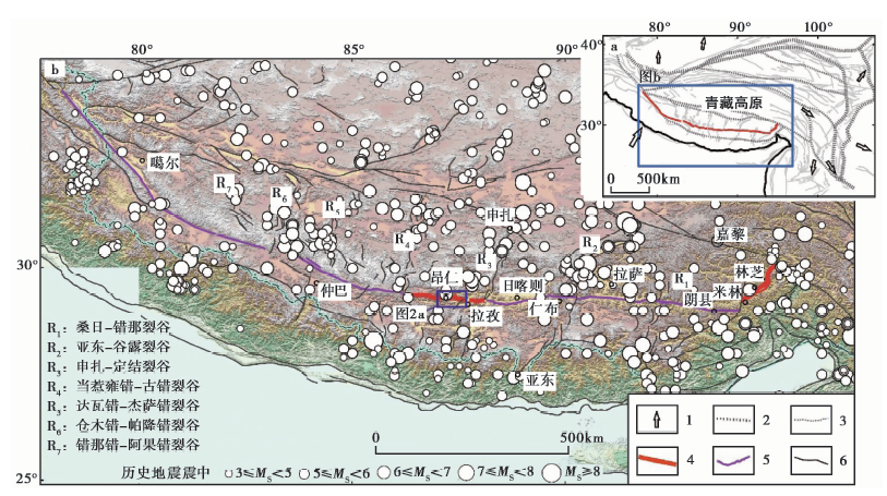 | 图 1 雅鲁藏布江断裂带断裂分布图 活动块体划分、 活动断裂等据邓起东等(2007)和文献①修改。 图b底图为SRTM数据。 1 活动块体运动方向; 2 一级活动块体边界; 3 二级活动块体边界; 4 雅鲁藏布江断裂带中发现晚第四纪活动证据的段; 5 雅鲁藏布江断裂带中未发现明确晚第四纪活动证据的段; 6 区域内其它活动断裂Fig. 1 Distribution of the Yarlung Tsangpo fault zone. |
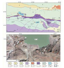
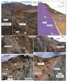
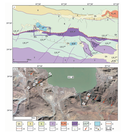 | 图 2 昂仁错附近区域地质(a)与构造地貌(b) a据地质图据文献(湖北省地质调查院, 2013; 中国地质调查局成都地质调查中心, 2013)修改。 b底图影像来自Google Earth。 1 全新统; 2 古近系; 3 白垩系; 4 三叠系; 5 晚白垩世结江岩体; 6 昂仁蛇绿岩群超基性岩段; 7 破姆弄混杂岩; 8 湖泊; 9 雅鲁藏布江断裂带中发现晚第四纪活动证据的段; 10 雅鲁藏布江断裂带中推测在晚第四纪发生过活动的段; 11 早— 中更新世断裂; 12 前第四纪断裂; 13 地层界线; 14 不整合地层界线; 15 水系及流向; 16 影像解译的线性迹线位置; 17 野外观测点位置及其编号; 18 地形剖面位置及其编号Fig. 2 Geology (a) and geomorphology (b) around Angren Lake. |
在仲巴以西, 断裂带走向以NW为主; 昂仁— 朗县间为近EW或NWW走向; 过朗县后自米林开始偏转至NE走向。 断裂北盘为冈底斯-下察隅岩浆弧, 主要由冈底斯中生代— 新生代中-酸性岩基组成, 南盘则是著名的雅鲁藏布江蛇绿岩带(王成善等, 1999; Yin et al., 2000; 杨经绥等, 2011; 湖北省地质调查院, 2013; 熊发挥等, 2016)(图2a)。 断裂带不同段的断面倾向和倾角不一, 多向S倾, 倾角一般在50° 以上, 断层破碎带的宽度也从数百m至数km不等。 已有研究显示该断裂带的发育演化经历了逆冲推覆、 构造挤压及走向滑动等一系列复杂过程(武长得等, 1990)。 米林以东段也称米林断裂带, 最新研究成果显示其在晚第四纪中发生过活动①(西藏自治区地震工程研究所, 2001, 西藏米林机场地震安全性评价报告。) (唐方头等, 2010; Li et al., 2018; 谢超, 2018)。 针对米林以西段开展的工作较少, 部分成果显示谢通门— 仁布段为早— 中更新世断裂②(西藏自治区地震工程研究所, 天津市地震灾害防御中心, 2015, 日喀则市活断层探测和地震危险性评价技术报告。), 但也有学者认为局部段在晚更新世仍有活动(彭小龙等, 2013)。
在日喀则以西, 雅鲁藏布江昂仁蛇绿岩带呈近EW向的带状广泛分布, 内部可见强烈的片理、 揉皱及破碎特征。 在昂仁错西南岸的观测点D1处(位置见图2b)可见厚层夹大量辉绿岩脉(墙)的灰绿色蛇绿岩群(J3K1AΣ ), 岩石碎裂化明显, 其内部发育多组劈理和断层破碎带(图3a), 但断层带物质(断层泥等)胶结程度较高, 显示其活动时代较早。 沿该蛇绿岩群向N, 在观测点D2处(位置见图2b)见其北界与白垩系昂仁组(K1-2a)砂岩呈断层接触(图3b), 基于区域地质资料(湖北省地质调查院, 2013; 中国地质调查局成都地质调查中心, 2013)判断该断层应属于雅鲁藏布江断裂带。
 | 图 3 昂仁错西南蛇绿岩及其构造特征 a 观测点D1处(位置见图2b)蛇绿岩群及其内部构造发育特征, 红色线条指示断层; b 观测点D2处(位置见图2b)蛇绿岩群构造特征及其与白垩系昂仁组地层(K1-2a)之间的断层。 红色箭头示意断层位置Fig. 3 The ophiolotes on the southwest of Angren Lake and their tectonic feature. |
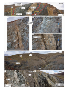
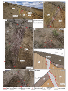
从高分辨率影像上看, 在观测点D2 NE方向的观测点D3附近, 可见1条具一定延伸长度的线性迹线(图2b), 走向NW, 且小冲沟具有同步左旋拐弯的现象(图4a), 地形剖面数据(图4b)和实地考察(图4c)均揭示该点山坡处略有坡折。 在该点的多个小冲沟沟壁上发现断层出露, 图 5展示了其中几个较为典型的断层剖面。 这些剖面均揭示断层基本断错至地表, 仅个别上覆极薄的表层坡洪积碎砾土。 断层倾向NE, 倾角约60° ~70° , 断面清晰, 见松散断层泥、 砾石定向排列等断层活动现象, 断层带宽多为15~30cm。 断层上盘为风化白垩系昂仁组(K1-2a)砂岩, 下盘为夹极少量小砾石的黄土(图5)。 在图5d和图5e所示剖面中可见黄土上覆发育的坡洪积砂砾石与上盘砂岩风化物之间亦呈断层接触, 砾石呈次磨圆或棱角状。
 | 图 4 观测点D3(位置见图2b)附近构造地貌 a D3点处影像(底图来自Google Earth)显示断层通过处小冲沟同步左旋拐弯, 绿色线条和及箭头指示冲沟及其流向, 红色线条指示断层; b D3点处地形剖面(底图为STRM数据, 位置见图2b所示的AA’剖面)显示该点处地形略有坡折, 标注的断层产状已考虑横纵坐标的比例; c D3点处构造地貌照片, 红色箭头指示断层位置Fig. 4 Geomorphology around the survey point D3(see Fig. 2b for the location). |
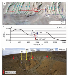
 | 图 5 观测点D3(位置见图2b)处断层剖面 各剖面位置见图4。 ① 砂黄土, 较松散, 夹很少量小砾石; ② 坡洪积砂砾石, 较松散, 砾石磨圆差; ③ 坡洪积砂砾石, 砾石磨圆差, 呈下粗上细的特征, 可能为坎前堆积单元。 光释光(OSL)样品由中国科学院地球环境研究所释光实验室测试(报告编号: IEEOSLIEEOSL201802)Fig. 5 Fault profiles at the survey point D3(see Fig. 2b for the location). |
在昂仁错东南岸的观测点D4一带, 影像上亦可见1条线性迹线, 沿NW方向具有一定的延伸长度(图2b), 并可见小冲沟左旋拐弯和 “ 断头沟” 现象(图6a)。 地形剖面数据和实地调查揭示该处为局部的负地貌或坡中谷(图6b, c), 其中1条冲沟的两壁出露断错至地表的断层面(图7), 倾向SW, 倾角约70° 。 下盘为昂仁蛇绿岩群(J3K1AΣ ), 呈现明显的碎裂化和透镜体化(图7a, e); 上盘为坡洪积含砾块黄土和砂砾石, 较松散, 砾石磨圆差, 局部见沉积层理。 断层带由砂砾石(夹黄土)定向带、 断层泥和断层角砾岩组成, 厚0.5~1.0m, 夹约5cm厚的松散断层泥(图7f)。 上盘近地表堆积物具坎前崩垮堆积的特点(图7b, d, f), 可能与地表破裂型地震事件有关。
 | 图 6 观测点D4(位置见图2b)附近构造地貌 a D4点处影像显示小冲沟左旋拐弯和 “ 断头沟” 现象; b D4点处地形剖面(位置见图2b所示的BB’剖面)显示该点处为局部负地形; c D4点处构造地貌照片, 显示坡中谷地貌。 符号意义同图4Fig. 6 Geomorphology around the survey point D4(see Fig. 2b for the location). |
根据图 6揭示的地形特征分析, 观测点D4处的下降盘为地势较高的山体一侧, 且图 7揭示的滑动面向下延伸至沟底, 而倾角(约70° )并没有变缓的迹象, 不具有局部重力滑动的空间, 故可排除此地形由滑坡所致的可能性, 而应由构造活动而形成。 同时该处断层带的物质明显可分为多期, 应经历了多次活动。
观测点D3揭示的断层为倾向NE的逆冲断层, 而在观测点D4观察到的是倾向SW的正断层, 变化明显。 断层的走滑运动常使局部断层的性质及断面参数沿断裂带发生变化, 且在2个观测点处均可观察到小冲沟左旋拐弯及 “ 断头沟” 现象(图4a, 6b), 因此2个观测点处断面参数的差异应为断裂的走滑运动所致。
 | 图 7 观测点D4处(位置见图2b)冲沟东壁(a— d)和西壁(e— f)断层剖面 a、 e所示剖面位置见图6, 符号意义同图5。 ①含砾砂黄土; ②粉砂质黏土夹砾石, 砾石呈棱角状, 分选不一; ③砾石层, 夹粉砂质黏土, 可见近水平沉积层理(白色虚线), 砾石分选较好, 磨圆差; ④砾石层, 堆积混乱, 呈楔状, 砾径下粗上细, 为较典型的坎前堆积单元Fig. 7 Fault profiles on the east wall(a— d)and west wall(e— f)of a small gully at the survey point D4(see Fig. 2b for the location). |
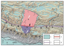
 | 图 8 雅鲁藏布江断裂带昂仁段构造活动模式示意图 A、 B为近SN向裂谷系及雅鲁藏布江断裂带所分割围限的块体, 白色箭头指示区域块体的运动方向(Wang et al., 2017; Zheng et al., 2017), 黑色箭头指示本文工作点的位置。 1 第四纪盆地; 2 雅鲁藏布江断裂带昂仁段(实线为发现晚第四纪活动证据的段, 虚线为推测晚第四纪活动的段); 3 雅鲁藏布江断裂带至今未发现晚第四纪活动证据的段; 4 区域内其它主要断裂。R2— R5为裂谷编号, 位置见图1Fig. 8 Schematic map of tectonic pattern of the Angren section of Yarlung Tsangbo fault zone. |
关于断层活动时代, 观测点D3和D4均揭示断层断错了局部发育的(含砾)黄土和坡洪积砂砾层, 野外观察发现2个地点的坡洪积物沉积特征相似, 均未见固结, 较为松散, 且局部具有一定沉积层理和坎前堆积物的特点。 于观测点D3处揭露的黄土中采集了2个光释光(OSL)年龄样品, 其测试结果分别为(94.68± 6.51)ka和(103.84± 5.14)ka(图5a)。 已有研究显示雅鲁藏布江沿线地区黄土广泛发育, 一般可分为2期(靳鹤龄等, 2000; 吴海锋等, 2016): 较老一期多分布于高阶地上, 成分较粗, 细砂含量> 30%, 实际上为黄土状土, 亦称为砂黄土, 形成于中更新世晚期— 晚更新世早期, 与本文在昂仁所发现的黄土的沉积特征和形成时代较为一致; 较新一期成分较细, 为传统概念的黄土, 形成于晚更新世晚期— 全新世时期。 昂仁剖面揭示断层断错了晚更新世早期的砂黄土及上覆的坡洪积砂砾石, 故可判断该断层在晚第四纪仍有活动。
虽然本文展示了雅鲁藏布江断裂带昂仁段的活动证据, 但经影像分析和野外观察发现, 可见明显活动迹象的段落延伸较短, 近年来关于雅鲁藏布江断裂带的最新工作成果也显示谢通门— 仁布段晚第四纪以来未活动
在昂仁错一带发现的多个断层剖面和年代学样品测定结果揭示雅鲁藏布江断裂带昂仁段晚第四纪以来有断错地表的活动。 影像判读和野外调查结果显示沿断裂带可见晚第四纪活动迹象的段落延伸较短。 结合已有资料和本次调查结果, 分析认为青藏高原南部地区当前新构造活动以近SN走向的裂谷系为主, 但被裂谷系分割的近EW向雅鲁藏布江断裂带可能具次级构造调节作用, 故其晚第四纪具有断错地表的活动。 但这种次级调节性活动可能较弱或较为局部, 因此沿断裂带未能发现较大规模的地表活动遗迹。
The authors have declared that no competing interests exist.
| [1] |
|
| [2] |
|
| [3] |
|
| [4] |
|
| [5] |
|
| [6] |
|
| [7] |
|
| [8] |
|
| [9] |
|
| [10] |
|
| [11] |
|
| [12] |
|
| [13] |
|
| [14] |
|
| [15] |
|
| [16] |
|
| [17] |
|
| [18] |
|
| [19] |
|
| [20] |
|
| [21] |
|
| [22] |
|
| [23] |
|
| [24] |
|
| [25] |
|
| [26] |
|
| [27] |
|
| [28] |
|
| [29] |
|
| [30] |
|
| [31] |
|
| [32] |
|