


背景噪声和地震面波联合反演渭河盆地及邻区壳幔S波速度结构
[冯红武1  , 颜文华
, 颜文华1 , 严珊1 , 郭瑛霞2 , 惠少兴1 , 常城1 ]
, 颜文华|
|


〔作者简介〕 冯红武, 男, 1985年生, 2014年于中国地震局兰州地震研究所获固体地球物理专业硕士学位, 工程师, 现主要从事地震层析成像研究, 电话: 029-88465302, E-mail: gsfenghw@126.com。
利用陕西及邻区测震台网和中国地震科学台阵探测项目共257个宽频带台站记录的连续波形与远震数据, 采用基于射线追踪的面波频散直接反演方法获得了渭河盆地及邻区地壳上地幔顶部S波速度结构, 成像结果显示: 1)渭河盆地顶部形成于新生代的沉积层造成其浅部显著的低速异常, 盆地中、 上地壳为低速结构, 低速带延深至约25km深处, 莫霍面相对两侧突变上隆, 上地幔高速体侵入下地壳, 可能与中—新生代上地幔基性-超基性铁镁质物质底侵有关。 2)南鄂尔多斯块体地壳浅层东薄西厚的低速结构可能与块体遭受的整体掀斜、 差异性抬升和强烈而不均匀的剥蚀有关。 壳内不存在明显的低速异常, 说明壳内低速体并没有贯穿整个鄂尔多斯地块, 鄂尔多斯南段仍保留着稳定克拉通属性, 至今还未遭受明显改造。 3)秦岭造山带东、 西深部结构存在差异, 具有分段特征。 造山带下地壳底部的低速异常, 可能与造山带受青藏高原东北缘隆升和向外扩展等构造活动的影响有关, 分析认为秦岭造山带存在青藏高原物质E流的下地壳流通道的可能性不大。
The Weihe Basin is the main component of the extrusion and escape shear zone between the ancient North China craton block in Ordos and the ancient Yangtze platform in Sichuan Basin, and carries the dynamic transmission from the main power source of the Qinghai-Tibet Block in the west to the North China and South China regions in the east. The basin itself plays multi roles in the east-west and north-south tectonic movement, and is an excellent site for studying the structural interlacing, dynamic transformation and transmission. At the same time, Weihe Basin is also a famous strong earthquake zone in China. Historically, there was a strong earthquake of magnitude 8 1/4 occurring in Huaxian County in 1556, causing huge casualties and property losses. In view of the special geological structures and the characteristics of modern seismicity activities in the Weihe fault-depression zone, it is necessary to carry out fine three-dimensional velocity structure detection in the deep part of Weihe Basin and its adjacent areas, so as to study the relationship between velocity structure and geological structural units and their evolution process, as well as the deep medium environment where earthquakes develop and occur.
We investigate the S-wave velocity structure beneath Weihe Basin and its adjacent regions based on continuous background noise data and teleseismic data recorded by 257 broadband stations in Shaanxi Province and its adjacent regions and China Seismological Science Array Exploration Project, and by adopting seismic surface wave inter-station method and background noise cross-correlation method, a total of 10049 fundamental-mode Rayleigh surface wave phase velocity dispersion curves in the periods of 5~70s are obtained. Firstly, using the average dispersion curve in this study area, we obtain the one-dimensional average S-wave velocity structure model of the study area, and then we apply the ray-tracing surface-wave-dispersion direct inversion method to obtain the S-wave velocity structure of the crust and uppermost mantle (3~80km) beneath Weihe Basin and its adjacent regions. The test results of a 1°×1°grid checker board show that the recovery is good, except for the areas east of 111°and south of 32°of the study area, where there is almost no resolution. The imaging results show that the velocity structure beneath each tectonic unit in the study area has a certain distribution rule, and there is a good correlation between surface geological structure and deep velocity structure.
Based on the analysis of velocity slices at different depths and S-wave velocity structures of three profiles, and combined with existing geological structures, geophysics and other deep exploration research results, we obtain the following knowledge and conclusions: 1)The thick sedimentary layer covering the top of Weihe Basin is the cause of low velocity anomaly in its shallow crust, the middle and upper crust of the basin are of low velocity structure, and the low-velocity zone extends about 25km, the Moho interface uplifts abruptly relative to both the Ordos Block and the Qinling orogenic belt on opposite sides, and high-speed materials from the upper mantle intrude into the lower crust, which may be related to the underplating of mafic-ultramafic materials from the upper mantle in Mesozoic-Cenozoic period; 2)The south Ordos Block is not a homogeneous whole, the low-velocity structure of the shallow crust in southern Ordos Block is thin in east and thick in west, which may be related to the overall tilting of the Ordos Basin since the Phanerozoic, as well as the differential uplift and strong and uneven denudation of the Ordos Block since the Late Cretaceous. The crustal structure of the south Ordos Block is relatively simple and homogeneous. There is no significant low-velocity structure in the curst of the block, which shows that the low-velocity structure in the crust does not penetrate the whole Ordos block. We speculate that the southern Ordos Block still maintains the stable craton property, and has not been reformed significantly so far; 3)The variation characteristics of deep structure of the Qinling orogenic belt reflect the deep crustal structure and tectonic deformation characteristics of the orogenic belt which are strongly reformed by land-land collision and suture between North China plate and Yangtze plate, intracontinental orogeny, uplift of Qinghai-Tibet Plateau and its northeastern expansion since the Late Hercynian-Indosinian period. The deep structure beneath the eastern and western Qinling orogenic belt is different and has the characteristics of segmentation. The low-velocity anomaly at the bottom of the lower crust of the orogenic belt may be affected by tectonic activities such as uplift and outward extension of the NE Tibetan plateau, and the analysis considers that there is little possibility of the existence of lower crustal circulation channel for the eastward flowing of Tibetan plateau materials in the Qinling orogenic belt. However, since the maximum depth from the inversion of this paper is 80km, which is located at the top of the upper mantle, our results cannot prove that there exists a mantle flow channel for the eastward flow of Tibetan plateau material beneath the Qinling orogenic belt.
渭河盆地整体处于青藏块体东北缘、 华北地块和华南地块的交界地区, 是一条重要的大地构造分界线。 盆地内部活动断裂十分发育, 构造比较复杂, 垂直差异运动和断块掀斜运动强烈, 第四纪沉积厚度大(国家地震局 “ 鄂尔多斯周缘活动断裂系” 课题组, 1988; 韩恒悦等, 2002)。 盆地南部为扬子块体与华北块体碰撞形成的秦岭造山带, 北部是稳定的鄂尔多斯块体。 渭河盆地作为鄂尔多斯古老华北克拉通块体和四川盆地古老扬子地台两大块体间挤出和逃逸剪切带的主要组成部分, 承载着来自青藏块体这一西侧主要动力源向东侧华北和华南地区的动力传递, 自身在东西和南北地质构造活动中扮演着多种角色, 是一个研究构造交织作用和动力转换、 传递的绝佳地点, 受到地学界的广泛关注。
渭河盆地也是中国著名的强地震带, 历史上曾发生过公元前780年沣镐7级地震、 1501年朝邑7级地震、 1556年华县8 1/4级地震和1704年陇县6级地震等强震, 这些地震造成了巨大的人员伤亡和财产损失。 但从目前的实际情况来看, 渭河盆地是环鄂尔多斯地块周缘现代地震活动最弱的地区, 特别是盆地中部的西安-周至断陷长期处于地震平静状态, 而该断陷周边的边界断裂晚第四纪以来活动强烈, 特别是南部边界断裂, 自全新世以来多次活动。 因此, 这种断裂强烈活动的构造背景和地震长期平静的不协调现象也可能预示着该断陷现在已具有很高的强震危险性, 处于 “ 亚失稳” 前期①(陕西省地震局, 2018, 陕西省“ 十二五” 重点项目《关中大震危险性评价》(内部研究报告)。)。 基于渭河断陷带特殊的地质构造和现代地震活动特点, 有必要开展对渭河盆地及邻区精细的深部三维速度结构探测, 研究探讨该区域的速度结构与地质构造单元及其演化过程的关系, 以及地震孕育和发生的深部介质环境。
尽管前人在渭河盆地及周边地区已开展了一系列深部地球物理研究(丁韫玉等, 2000; Zheng et al., 2010; 任隽等, 2012; 徐树斌等, 2013; 滕吉文等, 2014; 贺伟光等, 2015; 司芗等, 2016; 凌媛等, 2017; Wang et al., 2017), 但现有结果受到台站分布及覆盖密度、 天然地震分布及定位精度、 数据数量和质量以及剖面位置等因素的限制, 难以给出该地区整体的深部结构特征、 块体内部以及不同块体之间的深部结构变化细节特征, 制约了对该地区深部动力学过程的理解与认识。 中国地震科学台阵探测项目在南北地震带北段地区布设的高密度流动台阵, 为渭河盆地及周边地区的高分辨率地震波成像提供了难得的机遇。
基于地震面波双台法的面波成像方法一般可以获得台阵区域下地壳和上地幔的速度结构, 但由于短周期(< 20s)的面波信号随着传播距离的增加而迅速衰减, 一般很难获得短周期的面波频散, 因此地震面波双台法的面波成像方法很难得到中上地壳的速度结构(Yao et al., 2006)。 近年来发展起来的背景噪声成像方法正好弥补了地震面波在短周期上的不足, 其不受地震定位精度和震中位置的约束, 且射线路径覆盖更加均匀, 反演结果更加准确可靠。 目前该方法在速度结构研究中的应用越来越广泛, 可对几百m深的浅地表— 上地幔进行成像(Shapiro et al., 2005; Yao et al., 2008; 房立华等, 2009; 余大新等, 2014; Li et al., 2016; 王娟娟等, 2018)。
本文利用陕西及邻区测震台网和中国地震科学台阵探测项目共257个宽频带台站记录的地震事件和连续背景噪声数据, 通过地震面波和背景噪声提取了5~70s周期段的基阶Rayleigh面波相速度频散曲线。 根据平均频散曲线得到了研究区的一维横波速度结构, 并将其作为反演的初始模型, 然后利用所有路径的相速度频散曲线及基于射线路径追踪的面波频散直接反演方法(Fang et al., 2015), 获得了研究区精细的地壳、 上地幔三维S波速度结构, 并在此基础上探讨研究区速度结构分布特征、 地球动力学构造演化过程以及地震孕育和发生的机理。
本文选取陕西省及邻省区域台网固定台站和喜马拉雅二期流动台阵2014年1月— 2015年12月共257个宽频带地震台站的垂直向连续波形数据进行分析, 其中固定台站97个, 流动台站160个, 台站分布如图 1所示。
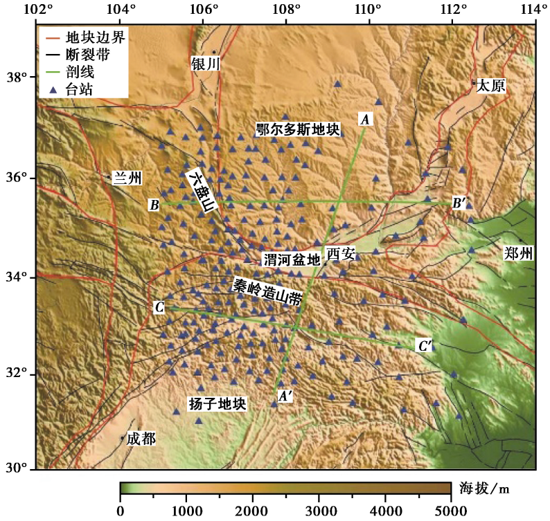 | 图 1 研究区的地形与地质构造图Fig. 1 The map of topography and geological setting in the study region. |
对天然地震事件截取波形, 利用地震面波双台法提取台站间的Rayleigh波频散曲线, 通过长时间连续背景噪声互相关计算获得台站间的互相关函数, 再进一步提取台站间的面波频散曲线。
采用天然地震面波双台法提取面波频散曲线时, 为了使提取的台站间相速度频散曲线更加可靠, 我们参照Yao等(2006)和余大新等(2014)的处理方法对天然地震事件做如下控制: 1)为保证地震面波记录清晰, 选取震级为5.0~7.5的地震事件, 震源深度< 60km; 2)为避免高阶面波的干扰和近场效应, 将震中距控制在10° ~100° ; 3)根据双台法的大圆弧理论, 为尽量保证地震面波传播时有一段近似相同的大圆弧路径, 规定较远台站到较近台站的方位角与较远台站到震中的方位角之差< 3° 的台站才能形成台站对参与计算。 依据上述控制条件, 本文共使用了86个地震事件(图2)。
 | 图 2 选取的远震震中分布图Fig. 2 The epicenter distribution of teleseisms selected in this study. |
背景噪声数据处理参考Yao等(2011)和Bensen等(2007)的方法, 首先将原始数据转成SAC格式, 由原采样率100Hz重采样至1Hz后以1d的时间尺度保存, 之后进行去均值、 去趋势、 带通滤波以及去仪器响应处理。 为了在后续归一化处理时更加高效地消除背景噪声中地震事件的干扰和压制背景噪声中的优势频率, 将带通滤波分成4个窄通道, 分别为3~5s、 5~10s、 10~20s和20~40s, 然后分别在4个通道分别进行one-bit时域归一化、 频谱白化和互相关计算并叠加, 最后将4个通道的互相关函数线性叠加为最终的互相关函数(图3)。 叠加的时间越长, 面波信号也越强, 且对称分量较非对称分量在各个周期上的信噪比高(Lin et al., 2008), 因此在后续数据处理中都使用对称分量。
 | 图 3 台站64020与其它台站的互相关函数Fig. 3 The cross-correlation function between the station 64020 and other stations. |
采用基于图像分析的方法(姚华建等, 2004; Yao et al., 2006)来提取相速度频散曲线, 与传统的等值线描点法相比, 此方法可以高效地追踪到各个周期的相速度频散点, 同时能提高测量精度。 对于天然地震面波双台法获得的互相关函数, 在实际提取过程中, 需结合地震仪器的频带宽度, 提取的相速度频散曲线的周期为20~70s。 而对于背景噪声互相关计算得到的互相关函数, 为了得到准确的频散曲线, 采用人工手动的方法提取, 且控制噪声互相关函数同时满足以下2个条件: 1)筛选出信噪比> 10的互相关函数用于频散曲线的提取; 2)须同时满足如下远场条件: CAB× T=λ ≤ Δ /3。 其中, CAB 表示平均相速度, λ 是波长, Δ 是台间距, T是测量周期。 相速度提取过程中最大测量周期由上式确定, 假设测量的平均相速度CAB 为4km/s, 研究中最大台间距约800km, 因此所提取的相速度频散曲线的周期主要分布在5~40s, 在此范围内测量的频散曲线才较为可靠。
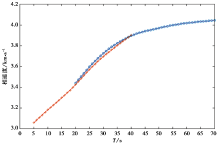
通过地震面波双台法和背景噪声互相关法分别得到7 222条和7 344条相速度频散曲线, 其中将地震面波双台法得到的相同路径互相关函数取平均值后得到4 468条互相关函数, 各自平均相速度频散曲线如图 4所示。 从图 4可以看出, 天然地震面波双台法得到的相速度在相同周期(20~40s)高于背景噪声得到的相速度, 速度差最大值为0.030 6km/s, 速度变化率 < 1%。 为使相速度频散曲线平滑过渡, 在20~40s周期取两者的平均值, 周期< 20s的相速度由背景噪声互相关函数得到, 周期> 40s的相速度由天然地震面波得到, 联合后共得到10 049条频散曲线。
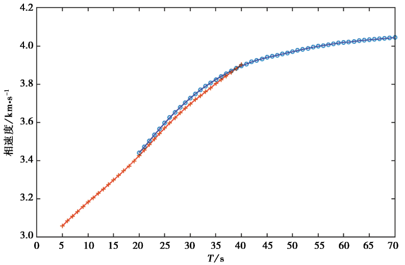 | 图 4 平均相速度频散曲线 红线和蓝线分别为背景噪声和地震事件双台法提取的平均相速度频散曲线Fig. 4 The average phase velocity dispersion curve. |
本文采用基于射线路径追踪的面波频散直接反演方法(Fang et al., 2015), 该方法基于射线追踪直接利用混合路径相速度频散曲线反演S波速度结构, 可称为一步反演方法。 相比传统的两步法, 省去了将混合路径频散数据离散到研究区域内的每一个网格点而得到相速度结构的步骤, 并且考虑了面波在复杂介质传播将偏离大圆路径的情况, 射线追踪计算使用快速行进法(Rawlinson et al., 2004)。
 | 图 5 由测量的相速度频散计算得到的初始模型 红点代表反演的初始模型Fig. 5 The initial model derived from measured phase velocity dispersion. |
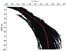
参考Fang等(2015)的方法, 本文的初始速度模型根据提取到的相速度频散曲线计算获得, 具体如下: 以往经验表明, 基阶Rayleigh面波相速度对于其1/3 波长深度处的S波波速最为敏感, 在均匀半空间泊松介质中, 相速度c与S波速度VS满足关系式c=0.92VS。 通过该关系可以得到一个合适的初始模型, 即将测量到的Rayleigh波相速度除以0.92即得到S波速度, 深度取其波长的1/3, 最后取平均便可得到研究区的初始速度模型(图5)。 在实际计算过程中, 结合该方法对初始模型参数的要求, 反演过程中将研究区沿经度和纬度方向均划分成34个网格, 平面网格大小为0.3° × 0.3° , 沿深度方向划分为17层, 经过反演后的速度模型如图 6所示。
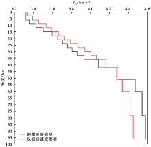
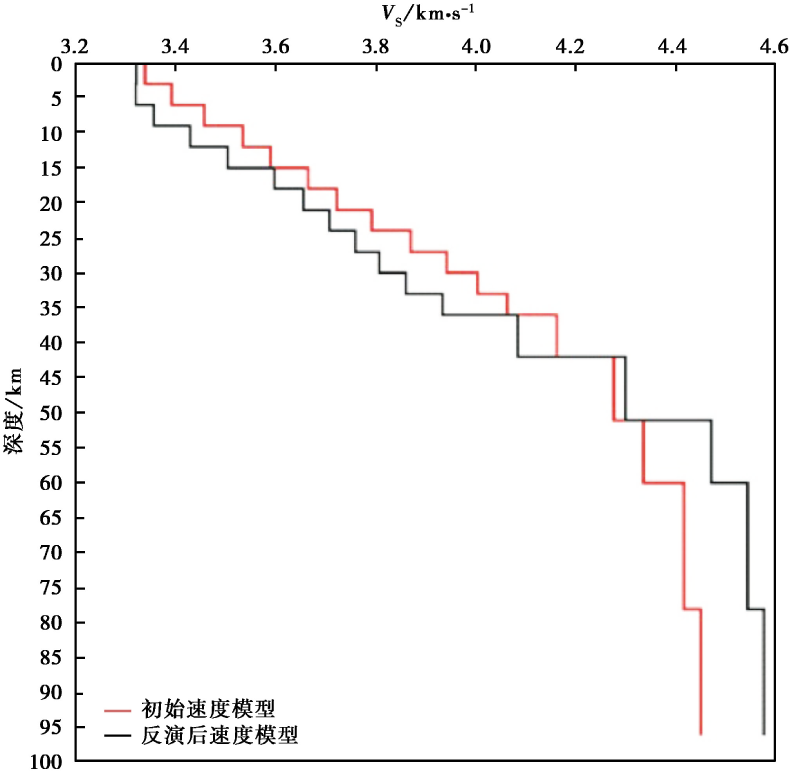 | 图 6 初始模型与反演后的速度模型Fig. 6 The initial velocity model and velocity model after inversion. |
为了验证层析成像结果的可靠性, 通常采用检测板测试方法对台站分布和射线路径的影响进行检测。 进行检测板测试时, 速度结构模型设置为正负相间的速度棋盘网格, 并在初始模型中输入一定的正负相间的速度扰动, 保持研究区域内的台站分布位置、 数目以及射线路径均不变。 通过检测板测试方法, 可非常直观地对成像结果的可靠性进行评判, 以正负相间的速度异常棋盘模型为参考, 若反演结果扰动值恢复得越好, 则表明该区域分辨率越好。 1° × 1° 网格的检测板测试结果表明在台站分布密集、 射线覆盖好的区域, 棋盘格得到较好的恢复, 除研究区111° E以东、 32° N以南区域几乎无分辨能力外, 其它区域均恢复较好(图7)。
 | 图 7 不同深度检测板的测试结果Fig. 7 Results of checkerboard test at different depths. |
本文基于射线追踪的面波频散直接反演方法, 获得了研究区3~80km深度范围内的S波速度结构图像。
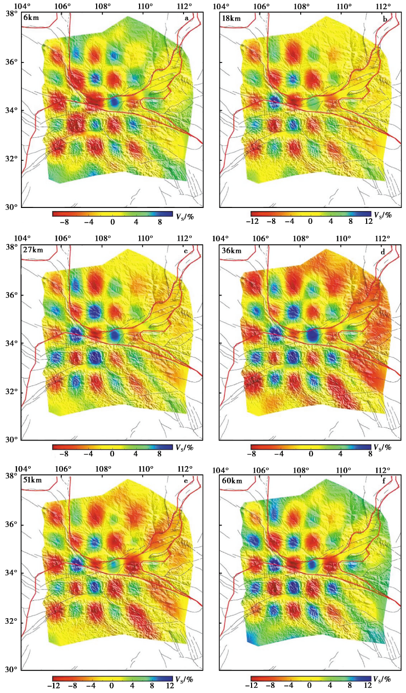
依据不同深度的速度分布特征, 给出了不同深度的速度切片(图8)。 可以看出, 研究区域各构造单元下方的速度结构有着一定的分布规律, 具体表现为:
(1)6km深度的水平速度切片(图8a)主要反映了地壳浅层部分和上地壳的速度结构特征。 可以看出, 速度异常分布与地表地质构造单元存在一定的相关性。 高速与低速异常分布反映了沉积层厚度、 结晶基底埋深的区域地质构造特征。 其中, 沉积层较厚的渭河盆地和南鄂尔多斯块体西缘表现为低速异常, 而秦岭造山带表现为相对高速异常; 六盘山逆冲褶皱带呈现弱高速异常; 高速异常与低速异常的分界与块体边界较为吻合。 这一深度的速度结构特征与前人的成像成果基本一致(Zheng et al., 2010; Li et al., 2013; 贺伟光等, 2015; 凌媛等, 2017; 郑晨等, 2018)。 另外, 南鄂尔多斯块体并不是一个均匀的整体, 其西缘速度较东缘低, 这可能是由于鄂尔多斯西缘具有新生代和部分中生代低速沉积盖层(刘宝峰等, 2003), 且其沉积层并不是对称的, 而是西部厚、 东部薄(邓军等, 2005)。
(2)18km深度的水平速度切片(图8b)主要反映了中上地壳的速度结构特征。 研究区低速异常主要分布在渭河盆地和秦岭造山带东部, 但S波低速结构的平均速度值整体升高。 研究区西部大部分地区表现为高速异常或弱高速异常, 汉中盆地和南鄂尔多斯西缘呈现出相对高速异常, 六盘山褶皱带和秦岭造山带西部则呈现弱高速异常。
(3)27km深度的水平速度切片(图8c)主要反映了中下地壳的速度结构。 其中, 南鄂尔多斯块体西缘表现为相对高速异常, 反映了地壳速度的正常变化; 秦岭造山带和六盘山褶皱带表现为相对低速异常, 尤其在鄂尔多斯块体内部的延安一带低速异常明显; 西安— 渭南— 华县地区表现为相对低速异常。 渭河盆地两侧表现为相对高速异常, 可以看出, 渭河盆地的速度结构表现出明显的横向不均匀特征。
 | 图 8 不同深度S波速度分布图像Fig. 8 S-wave velocity distribution images at different depths. |
(4)36km深度的水平速度切片(图8d)主要反映了下地壳和上地幔顶部的速度变化特征。 总体看来, 研究区东部高速异常显著, 而西部低速异常明显。 其中渭河盆地呈现出明显的高速异常; 六盘山褶皱带、 南鄂尔多斯块体和秦岭造山带表现为相对低速异常, 但秦岭造山带和南鄂尔多斯块体东、 西两侧横向不均匀, 西部速度均较东部更低。 人工地震测深和接收函数研究结果(童蔚蔚等, 2007; 任隽等, 2012; 徐树斌等, 2013; 李英康等, 2015; 李文辉等, 2017)表明, 研究区莫霍面深度自西向东变浅。 因此, 这一深度的S波速度异常变化反映了研究区地壳东薄西厚的结构特征。
(5)51km深度的水平速度切片(图8e)主要反映了下地壳和上地幔顶部的速度变化特征。 总体来看, 研究区速度横向变化剧烈, 反映出地壳底部和上地幔顶部复杂的深部结构。 六盘山褶皱带及邻区、 秦岭造山带西部因具有较厚的地壳, 此深度还属于地壳部分, 速度结构特征表现为显著的低速异常。 渭河盆地表现为相对高速异常, 反映了渭河盆地莫霍面深度较浅的特点。
(6)60km深度的水平速度切片(图8f)主要反映了上地幔顶部的速度变化特征。 南鄂尔多斯块体和秦岭造山带在此深度表现为明显的高速异常, 而渭河盆地呈现出高、 低速异常兼具的特征。 六盘山逆冲褶皱带表现为低速异常。
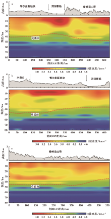
图 9为沿几条重要位置和方向切割的速度垂向剖面, 可充分展现研究区不同构造单元的速度结构特征。 由于面波方法对莫霍界面的深度约束不强, 仅能在一定程度上反映莫霍面的变化范围, 为便于讨论, 我们根据接收函数的研究结果(Li et al., 2014)在各剖面中描绘出平均莫霍面深度。
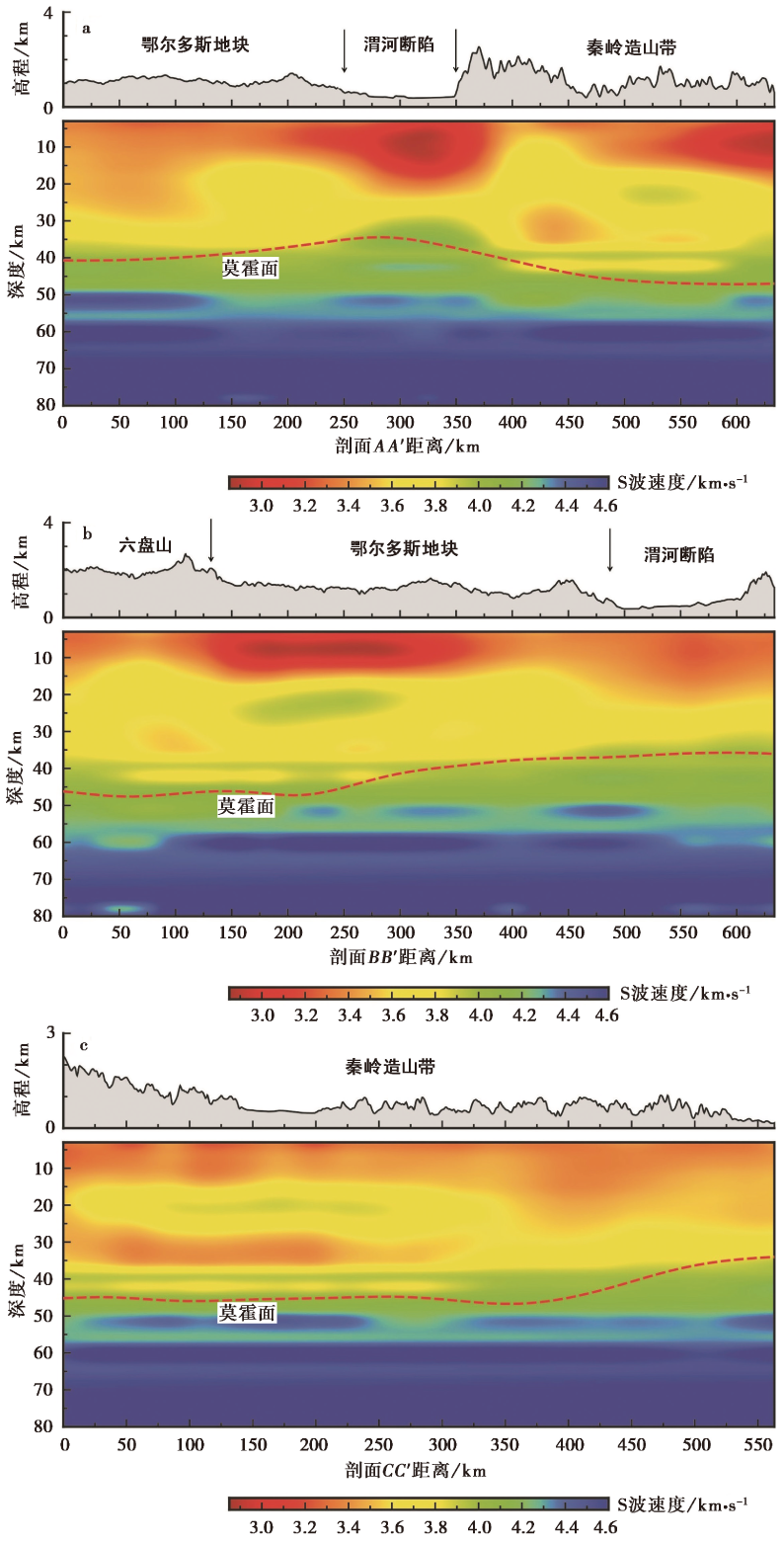 | 图 9 沿图 1中剖线AA’、 BB’、 CC’的剪切波速度结构剖面与地形图Fig. 9 Vertical profile of shear wave velocity structure and topographic map along the lines AA’, BB’, and CC’ in Fig. 1. |
剖面AA’(图1)由北向南先后穿过鄂尔多斯块体、 渭河断陷盆地和秦岭造山带, 图9a揭示了该路径下方的S波速度结构变化, 很好地反映了3个构造单元不同的地壳结构特征。 受沉积层厚度的影响, 渭河断陷盆地的上地壳及其顶部表现为低速异常。 盆地中上地壳为低速结构, 低速带延深至约25km深处, 莫霍界面相对于两侧明显上隆, 下地幔高速体上涌至下地壳底部。 相比南鄂尔多斯块体下方简单的地壳速度结构, 秦岭造山带的地壳速度结构就显得更为复杂, 存在部分高速异常和低速异常, 尤其是造山带下方莫霍面附近出现明显的低速异常带。
剖面BB’(图1)自西向东先后穿过六盘山逆冲褶皱带、 鄂尔多斯块体和渭河断陷盆地, 图9b揭示了该路径下方的S波速度结构变化。 南鄂尔多斯西缘和东缘表现出不同的地壳速度结构特征, 块体东缘地壳结构相对简单和均一, 而块体西缘的上地壳则表现出更强的低速异常, 中地壳存在约10km厚的高速异常带, 块体中下地壳较南侧的渭河盆地速度高。 六盘山逆冲褶皱带的中下地壳存在低速异常, 且其莫霍面顶部(40~45km深度范围)也存在低速异常带。 接收函数结果(童蔚蔚等, 2007; 陈强森等, 2013)也表明六盘山地区地壳中下部存在低速区。
剖面CC’(图1)自西向东沿秦岭造山带方向穿过, 图9c揭示了该路径下方的S波速度结构变化。 该剖面最明显的变化特征是秦岭造山带东、 西部地壳结构具有不同的速度特征, 具体表现为: 造山带西部中地壳存在高速带(深度范围15~30km), 且其下方莫霍面顶部存在1条低速异常带。
基于背景噪声和地震面波联合反演获得了渭河盆地及邻区地壳上地幔速度结构, 成像结果揭示出地表地质构造与深部速度结构具有很好的相关性。 本文根据高分辨率的成像结果, 结合现有的地质构造、 地球物理和其它深部探测研究成果, 分析探讨速度结构与区域地质构造的关系、 块体构造演化的深部动力学过程以及地震孕育发生的深部环境。
本文的成像结果显示渭河盆地地壳浅部存在显著的低速异常, 反映出盆地顶部上覆较厚的沉积层。 地质及地球物理方法研究表明, 渭河盆地顶部沉积层形成于新生代, 沉积层最厚达7~8km(国家地震局 “ 鄂尔多斯周缘活动断裂系” 课题组, 1988)。 渭河断陷盆地中上地壳为低速结构, 低速带延深至约25km深处, 莫霍界面相对于两侧明显上隆, 上地幔高速体上涌至下地壳底部(剖面AA’), 这与人工地震和地球物理研究结果基本吻合。 任隽等(2012)的人工地震结果显示渭河盆地莫霍面相对于两侧的鄂尔多斯块体和秦岭造山带上隆, 上地幔高速物质侵入下地壳。 接收函数研究结果(Wang et al., 2014; 危自根等, 2015)表明渭河盆地的莫霍面明显凸起, 地壳厚度较薄, 泊松比较高。 重力资料研究结果(路利春等, 2017)也表明渭河盆地下方莫霍面相对两侧明显不对称地隆起, 形成复杂的地壳结构, 使得渭河盆地构造活动频繁。 贾萌等(2015)认为渭河盆地内部莫霍面明显上隆, 可能是由于青藏高原上地幔物质沿鄂尔多斯块体与秦岭之间向E挤出并上涌所致。 司芗等(2016)研究认为渭河盆地的地壳减薄是由于下方热物质上涌导致壳内存在部分熔融而发生热拉张所致。 背景噪声成像分析(凌媛等, 2017)认为陕西— 山西断陷区及附近区域的下地壳至壳幔边界表现出强的正径向各向异性特征, 可能与中— 新生代地幔基性-超基性铁镁质物质底侵有关。 Wang等(2014)认为该区域因其自身结构性质而成为构造薄弱带, 可能存在深部热物质上涌、 下地壳铁镁质物质增加或壳内局部熔融的现象。 Hu等(2000)的大地热流统计结果表明该区域附近地表热流较高。 结合本文的成像结果和前人的研究成果推测, 渭河断陷盆地属构造薄弱带, 在中— 新生代构造和岩浆作用下, 其深部上地幔基性-超基性物质可能已经上涌至盆地的壳幔边界, 受地壳伸展减薄作用的影响, 在下地壳底部附近堆积和扩展。
已有研究结果认为鄂尔多斯块体南北段的地壳厚度和波速比(Wang et al., 2014)、 岩石圈厚度(陈凌等, 2010)、 各向异性(常利军等, 2011)及电性结构(李晨晶等, 2017)等特征存在差异, 不同的研究结果对块体南、 北分界线的划定不完全一致, 但基本以(38° ± 0.5° )N为界。 本文的研究区域在38° N以南。
从本文的成像结果来看, 南鄂尔多斯块体内部速度横向变化较小, 与其地震活动弱、 断裂发育较少的特征相吻合。 但块体东、 西部的速度结构特征存在差异, 其东部地壳结构较为单一和均匀, 成层性好, 而剖面BB’(图9b)显示块体西部中地壳存在约10km厚的高速异常带。 陈强森等(2013)的接收函数结果显示鄂尔多斯块体南缘中地壳的上部存在高速区; 在上地壳约12km深度以上的范围, 南鄂尔多斯西缘较其东缘有更低的S波速度, 这主要是受沉积盖层厚度的影响。 凌媛等(2017)的噪声成像结果显示鄂尔多斯块体浅部存在较厚的1° ~2° 向W倾斜的低速异常结构, 可能与鄂尔多斯沉积盆地在显生宙时期整体掀斜的构造过程相对应。 该区域布格重力异常值表现出西低东高的特征(Pavlis et al., 2012), 王椿镛等(2017)据此推测鄂尔多斯块体可能曾经发生过整体倾斜, 与鄂尔多斯高原的覆盖层下出露的沉积地层 “ 东边老、 西边新” 所反映的地质现象(马丽芳, 2007)是一致的。 大地热流结果(黄方等, 2015)也揭示鄂尔多斯地块东部的热流值相对较高, 约65mW· m-2, 西部则相对较低, 约55mW· m-2。 地震各向异性的结果表明, 在鄂尔多斯块体内部快波方向在块体北部为近SN向, 而块体南部则为EW向(常利军等, 2011)。 可见, 不同地球物理方法得到的研究结果均说明南鄂尔多斯块体的东、 西部存在结构性差异。 我们认为, 南鄂尔多斯块体地壳浅层东薄西厚的低速异常结构可能与鄂尔多斯盆地自显生宙时期开始的整体掀斜(邓军等, 2005)以及晚白垩纪以来鄂尔多斯遭受的差异抬升和强烈而不均匀的剥蚀改造有关(刘池洋等, 2006)。
在鄂尔多斯块体北段, 背景噪声成像、 接收函数和电磁测深等研究结果(Zheng et al., 2009; 赵国泽等, 2010; Cheng et al., 2013; 李晨晶等, 2017)显示块体中下地壳存在大尺度的低速、 低阻层, 其展布范围和具体形态具有空间差异性。 本文的反演结果显示, 鄂尔多斯南段壳内低速体并不明显, 与鄂尔多斯北段广泛分布显著的壳内低速体所不同, 说明壳内低速体并不贯穿整个块体内部, 与其它研究结果(Cheng et al., 2013; 贾萌等, 2015; 凌媛等, 2017)基本一致。 已有研究表明, 南鄂尔多斯块体具有相对稳定的泊松比(Wei et al., 2011), 其地壳S波的速度结构与径向各向异性具有良好的连续性(凌媛等, 2017), 大地热流值较低且地震和岩浆活动较少(Zhai et al., 2003), 鄂尔多斯块体南段的岩石圈厚且为高速结构, 岩石圈地幔具有典型克拉通的结构特征(陈凌等, 2010)。 综合以上分析, 我们认为南鄂尔多斯地区的地壳结构相对简单和均一, 不存在显著的壳内低速体, 其地壳结构可能反映了克拉通早期形成时的结构特征, 且仍然保留着稳定克拉通的属性, 至今还未被明显改造。
剖面CC’(图9c)揭示了秦岭造山带东、 西部地壳的速度结构不同, 这表明秦岭造山带东、 西部深部结构的差异具有分段的特征(杨志华等, 2002)。 区域地质综合研究结果表明: 秦岭— 大巴造山带及邻区在长期地质构造的作用下, 一方面形成了现今地表地质构造的分区性和差异性, 另一方面则造成了浅表层与深部的地球物理场特征之间明显的不协调性(周鼎武等, 2002)。 深地震反射成像结果揭示扬子板块向N俯冲, 从而导致秦岭造山带沿EW向的地壳结构复杂性和明显分区(李洪强等, 2014)。 人工地震剖面和接收函数结果(李英康等, 2015; 司芗等, 2016)揭示了秦岭造山带莫霍面整体形态呈现起伏的向W倾斜的台阶式增深的特点, 东部浅、 西部深, 东、 西部的莫霍面深度相差10~12km, 莫霍面与地表高程呈镜像。 本文的成像结果显示在造山带上地壳9~12km深度范围内, 秦岭造山带东部的速度较西部高, 这与贺伟光等(2015)的背景噪声成像结果基本吻合。 这一成像结果也支持地质学研究的观点, 即秦岭海从晚二叠纪开始到晚三叠纪结束向W关闭, 东部的海相沉积岩比西部的年代更古老(Seguin et al., 1995)。 秦岭褶皱带内众多大面积基底隆起, 有高压变质基底等古老基底剥露(张国伟等, 1995)。 秦岭造山带西部中地壳存在高速带(深度范围12~22km), 西部速度较东部高, 这与其它研究结果(贺伟光等, 2015; 李英康等, 2015)相一致, 其原因可能是在板块碰撞、 造山的过程中, 下地壳的物质被抬升进入中地壳, 使中地壳的速度偏高。 CC’剖面显示在秦岭造山带西部的下地壳底部(约42km深)存在低速异常带, AA’剖面也揭示其下方莫霍面顶部存在低速异常, 这与已有研究的成像结果(贺伟光等, 2015; Song et al., 2018)较为一致。
有学者(Enkelmann et al., 2006; 常利军, 2011; 贺伟光等, 2015)认为秦岭造山带下方有可能存在青藏高原物质E流的通道, 但是地壳各向异性结果揭示青藏高原东北缘壳幔耦合一致变形, 并不支持上述观点(Wang et al., 2016)。 接收函数研究结果(司芗等, 2016; 王兴臣等, 2017)表明秦岭造山带的泊松比< 0.26, 表征该区域的地壳物质组分主要为长英质矿物, 暗示基性铁镁质的下地壳较其酸性长英质的上地壳更薄或存在缺失现象。 深地震测深剖面显示该区的地壳底部缺少VP> 6.9km/s的铁镁质岩石层(任隽等, 2012; 滕吉文等, 2014), 取而代之的是交替的长英质和中性层。 而处于熔融状态或部分熔融状态的地壳流则会使地壳具有较高的泊松比, 因此如果秦岭造山带地壳下方存在着青藏高原物质E流的通道, 则泊松比应更高。 贺伟光等(2015)的背景噪声成像结果认为秦岭造山带下方(深度范围40~50km)的低速异常可能与青藏高原物质E流有关。 Song等(2018)研究结果表明秦岭造山带的中下地壳存在1个NE-SW向的低速带结构, 揭示了青藏高原东北缘地壳中的低黏滞性物质没有向E流向东秦岭, 且青藏高原东北缘的侧向生长仅使其东侧板块的地壳结构产生刚性的小范围变形。 综合这些结果, 我们推测秦岭造山带下方存在青藏高原物质E流的下地壳流通道的可能性不大, 但其下地壳底部的低速异常带(剖面AA’和CC’成像结果)可能与造山带受青藏高原东北缘的隆升和向外扩展等构造活动的影响有关。 由于本文反演结果的最大深度为80km, 处于上地幔顶部, 故以上研究结果还不能证明秦岭造山带下方存在着青藏高原物质E流的地幔流通道。
本文利用陕西及邻区测震台网和 “ 中国地震科学台阵探测” 项目共257个宽频带台站记录的连续波形资料与远震数据, 联合反演背景噪声和天然地震面波的频散资料, 获得了渭河盆地及其邻区高分辨率的深度范围为3~80km的三维S波速度结构, 对3个剖面的S波速度结构进行了分析, 结合该区已有的地质和地球物理研究成果, 主要得到以下认识和结论:
(1)渭河盆地顶部形成于新生代的厚沉积层造成其浅部显著的低速异常, 盆地的中上地壳为低速结构, 低速带延深至约25km深处, 莫霍界面相对两侧明显上隆, 上地幔高速体上涌至下地壳底部。 作为构造薄弱带的渭河盆地在中— 新生代构造和岩浆的作用下, 上地幔基性-超基性物质可能已经上涌至盆地的壳幔边界, 受地壳伸展减薄作用的影响, 在下地壳底部堆积和扩展。
(2)南鄂尔多斯块体并不是一个均匀的整体, 其地壳浅层东薄西厚的低速异常结构可能与鄂尔多斯盆地自显生宙以来的整体掀斜以及晚白垩纪以来盆地遭受的差异抬升和强烈而不均匀的剥蚀有关。 南鄂尔多斯块体下方不存在显著的壳内低速体, 说明壳内低速体并没有贯穿整个鄂尔多斯地块, 据此推测南鄂尔多斯块体仍保留着稳定克拉通的属性, 至今还未遭受明显改造。
(3)秦岭造山带深部结构的变化特征反映了造山带经历自晚海西-印支期华北板块与扬子板块的陆-陆碰撞与缝合、 陆内造山、 青藏高原隆升以及向NE扩张等作用的强烈改造后, 其地壳深部结构和构造的变形特征。 秦岭造山带东、 西部深部结构存在差异, 具有分段的特征。 造山带下地壳底部存在的低速异常可能与造山带受青藏高原东北缘侧向生长等构造活动的影响有关, 分析认为秦岭造山带存在青藏高原物质E流的下地壳流通道的可能性不大, 但本文的结果无法证明秦岭造山带下方存在着青藏高原物质E流的地幔流通道。
致谢 中国地震局地球物理研究所 “ 中国地震科学探测台阵数据中心” 为本研究提供了地震波形数据; 中国科学技术大学姚华建教授提供了背景噪声计算程序; 审稿专家提出的问题和建议提高了本文的质量。 在此一并表示感谢!
The authors have declared that no competing interests exist.
| [1] |
|
| [2] |
|
| [3] |
|
| [4] |
|
| [5] |
|
| [6] |
|
| [7] |
|
| [8] |
|
| [9] |
|
| [10] |
|
| [11] |
|
| [12] |
|
| [13] |
|
| [14] |
|
| [15] |
|
| [16] |
|
| [17] |
|
| [18] |
|
| [19] |
|
| [20] |
|
| [21] |
|
| [22] |
|
| [23] |
|
| [24] |
|
| [25] |
|
| [26] |
|
| [27] |
|
| [28] |
|
| [29] |
|
| [30] |
|
| [31] |
|
| [32] |
|
| [33] |
|
| [34] |
|
| [35] |
|
| [36] |
|
| [37] |
|
| [38] |
|
| [39] |
|
| [40] |
|
| [41] |
|
| [42] |
|
| [43] |
|
| [44] |
|
| [45] |
|
| [46] |
|
| [47] |
|
| [48] |
|
| [49] |
|
| [50] |
|
| [51] |
|
| [52] |
|
| [53] |
|
| [54] |
|
| [55] |
|
| [56] |
|
| [57] |
|
| [58] |
|
| [59] |
|
| [60] |
|