


三危山活动断裂的水平运动特征与机制——对青藏高原北缘生长的限定
[云龙1)  , 张进
, 张进2) , 王驹1) , 凌辉1) , 张竞嘉1) , 张北航2) , 赵衡2) ]
, 张进|
|


〔作者简介〕 云龙, 男, 1985年生, 2014年于核工业北京地质研究院获工程地质专业博士学位, 高级工程师, 现主要从事活动构造及高放废物地质处置库选址方面的研究, 电话: 010-84855541, E-mail: yunlneotectonic@126.com。
三危山断裂为阿尔金断裂带东段的重要分支, 位于青藏高原北缘NW向扩展的前缘位置, 是一条左旋走滑兼逆冲的活动断裂。 经卫片解译和野外实际调查发现, 三危山主断裂穿过鸣沙山后, 向W至党河水库及阳关镇附近以断层陡坎的形式出露地表。 沿主断裂及其西延部分, 断裂左旋断错了不同级别的水系(冲沟和纹沟)和山脊, 形成一系列断错微地貌, 断错水系的规模与水平位移量呈正相关。 水平位移量的频率统计分析显示位移量存在明显的分级特征, 可分为6级, 对应的峰值分别为3.4m、 6.7m、 11.4m、 15m、 22m和26m, 各级之间的增量为3~4m。 其中, 3.4m代表了最新一次古地震事件的同震位移量, 而更大的位移量峰值则代表了多次古地震事件累积的同震位移量。 这种位移量近似等间隔增加的特征, 表明三危山断裂在晚第四纪以来存在多期次的地震活动, 具有特征型地震的活动特点, 具有发生7级以上地震的可能性。 三危山断裂的位错量分布和端部的构造转换等特征, 显示其可能是一条处于幼年期的“阿尔金断裂”, 该断裂的活动及其伴随的山体隆升是青藏高原北缘整体压剪作用的结果, 代表了高原北缘的一种生长方式。
The northern margin of the Qinghai-Tibet Plateau is currently the leading edge of uplift and expansion of the plateau. Over the years, a lot of research has been carried out on the deformation and evolution of the northeastern margin of the Qinghai-Tibet Plateau, and many ideas have been put forward, but there are also many disputes. The Altyn Tagh Fault constitutes the northern boundary of the Qinghai-Tibet Plateau, and there are two active faults on the north side of the Altyn Tagh Fault, named Sanweishan Fault with NEE strike and Nanjieshan Fault with EW strike. Especially, studies on the geometric and kinematic parameters of Sanweishan Fault since the Late Quaternary, which is nearly parallel with the Altyn Tagn Fault, are of great significance for understanding the deformation transfer and distribution in the northwestward extension of the Qinghai-Tibet Plateau. Therefore, interpretation of the fault landforms and statistical analysis of the horizontal displacement on the Sanweishan Fault and its newly discovered western extension are carried out in this paper. We believe that the Sanweishan Fault is an important branch of the eastern section of the Altyn Tagh fault zone. It is located at the front edge of the northwestern Qinghai-Tibet Plateau and is a left-lateral strike-slip and thrust active fault. Based on the interpretation of satellite imagery and microgeomorphology field investigation of Sanweishan main fault and its western segments, it's been found that the Sanweishan main fault constitutes the contact boundary between the Sanweishan Mountain and the alluvial fans. In the bedrock interior and on the north side of the Mogao Grottoes, there are also some branch faults distributed nearly parallel to the main fault. The main fault is about 150km long, striking 65°, mainly dipping SE with dip angles from 50° to 70°. The main fault can be divided into three segments in the spatial geometric distribution: the western segment(Xizhuigou-Dongshuigou, I), which is about 35km long, the middle segment(Dongshuigou-Shigongkouzi, Ⅱ), about 65km long, and the east segment(Shigongkouzi-Shuangta, Ⅲ), about 50km long. The above three segments are arranged in the left or right stepovers.
In the west of Mingshashan, it's been found that the fault scarps are distributed near Danghe Reservoir and Yangguan Town in the west of Minshashan Mountain, and we thought those scarps are the westward extension of the main Sanweishan Fault. Along the main fault and its western extension, the different levels of water system(including gullies and rills)and ridges have been offset synchronously, forming a series of fault micro-geomorphology. The scale of the offset water system is proportional to the horizontal displacement. The frequency statistical analysis of the horizontal displacement shows that the displacement has obvious grouping characteristics, which are divided into 6 groups, and the corresponding peaks are 3.4m, 6.7m, 11.4m, 15m, 22m and 26m, respectively. Among them, 3.4m represents the coseismic displacement of the latest ancient earthquake event, and the larger displacement peak represents the accumulation of coseismic displacements of multi-paleoearthquake events. This kind of displacement characterized by approximately equal interval increase indicates that the Sanweishan Fault has experienced multiple characteristic earthquakes since the Late Quaternary and has the possibility of occurrence of earthquakes greater than magnitude 7. The distribution of displacement and structural transformation of the end of the fault indicate that Sanweishan Fault is an “Altyn Tagh Fault”in its infancy. The activities of Sanweishan Fault and its accompanying mountain uplift are the result of the transpression of the northern margin of the Qinghai-Tibet Plateau, representing one of the growth patterns of the northern margin of the plateau.
青藏高原北缘是目前高原隆升和扩展的前缘, 多年来众研究者针对高原东北缘的变形和演化开展了大量的研究, 提出了很多认识, 但也存在激烈的争论(郭召杰等, 2008; Xiao et al., 2011, 2015; Zhang et al., 2012, 2014; Yuan et al., 2013; Zheng et al., 2013; Wang et al., 2016; Yu et al., 2016, 2017; Zuza et al., 2016)。 与上述研究相比, 目前针对高原北缘的生长模式和影响范围的研究尚少(Cunningham et al., 2016; Zhuang et al., 2018)。 青藏高原的北缘是著名的阿尔金走滑断裂及其北侧的三危山断裂, 目前的研究主要集中在阿尔金断裂的演化、 活动性以及深部结构等方面(Yin et al., 2002; Cowgill et al., 2004a, b; Xiao et al., 2011)。 李海兵等(2004)和潘家伟等(2015)曾提及高原北缘三危山的隆升与逆冲运动是伴随着阿尔金断裂带走滑运动的结果。 Cunningham等(2016)结合卫片解译和野外调查结果, 提出高原北缘NW向扩展的前缘已至三危山地区, 三危山断裂和南截山断裂为阿尔金断裂带东段的分支, 空间上与阿尔金断裂带共同组成区域性的非对称半花状构造。 已有研究强调了三危山断裂在高原北缘NW向扩展过程中扮演的关键角色, 但对高原NW向扩展过程中涉及的形变传递与分配方式还存在不同认识, 其主要原因就是缺少三危山断裂的一些基本的几何学和运动学参数。 因此, 研究该断裂晚第四纪以来的运动特征及其位移分布对探讨这一问题有着重要意义。 本文综合目前已有的断错地貌证据, 对三危山主断裂及其西延部分的断错地貌类型进行了系统整理, 并对断裂水平位移量的空间分布特征进行了讨论。 在此基础上, 综合前人的研究成果讨论青藏高原北缘的生长机制。
三危山断裂是与阿尔金断裂平行的一条断裂。 以往的三危山断裂指西起西水沟, 向E经芦草沟、 十工口子至双塔水库附近的段(图 1), 本文称之为三危山主断裂, 其构成三危山山体与冲洪积台地的接触边界。 此外, 在基岩山体内部以及莫高窟北侧的冲洪积台地上也有与主断裂近平行的分支断裂分布。 主断裂NW侧主要分布下更新统玉门组(
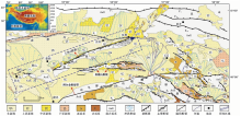
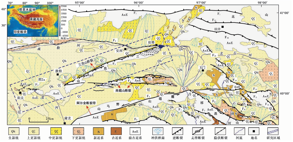 | 图 1 青藏高原北缘主要断裂分布图 F1红柳园断裂; F2疏勒河断裂; F3三危山断裂; F4南截山断裂; F5阿尔金断裂; F6大雪山断裂; F7昌马断裂; F8旱峡-大黄沟断裂; F9玉门断裂; F10新民堡断裂; F11阴洼山断裂; F12嘉峪关断裂; F13黑山断裂; F14塔尔湾-登登山-池家刺窝断裂; F15豁路山断裂; F16红旗山断裂; F17金庙沟断裂Fig. 1 Distribution of faults in the northern margin of Qinghai-Tibetan Plateau. |
根据主断裂的几何展布方式可将其分为3段: 西水沟— 东水沟为西段(Ⅰ ), 长约35km; 东水沟— 十工口子为中段(Ⅱ ), 长约65km; 十工口子— 双塔为东段(Ⅲ ), 长约50km。 3条断裂段呈左阶或右阶排列(图2a)。 关于主断裂的活动性, 张裕明等(1989)认为其为一条继承性的第四纪活动断裂, 晚更新世以来停止活动, 取而代之的是区域性的间歇抬升。 近期的研究结果表明, 断裂在晚更新世和全新世均有过活动(云龙等, 2016a, b)。
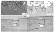
 | 图 2 三危山主断裂及西延部分的空间几何展布及断错地貌 a ETM影像; b 断裂及地层分布; c 党河水库段影像, 视向NE(来自Google Earth); d 党河水库段断错地貌; e 无人机航拍的阳关镇段断错地貌Fig. 2 Geometrical map of Sanweishan main fault, the western segment and its geomorphology. |
在此基础上, 沿主断裂走向向W, 发现在鸣沙山西侧的党河水库和阳关镇附近有断层陡坎出露, 为主断裂的西延部分, 将这2段分别称为党河水库段和阳关镇段。 其中, 党河水库段长约16km, 走向近EW, 由于断裂的逆冲运动, 形成高0.7~5.4m不等的断层陡坎(图2c, d)。 沿该段继续向W, 阳关镇段与主断裂近平行, 长约20km, 于地表形成高4~9m不等的断层陡坎(图2e)。 此外, 阳关镇段NW侧还出露2条长2.1和9.2km的断层陡坎(图2a, b), 以上陡坎的高度参数见文献(云龙等, 2019)。 从空间分布来看, 主断裂的西延部分由一系列与主断裂平行或小角度相交的段组成, 这些段在地貌上表现为高度不等的断层陡坎。
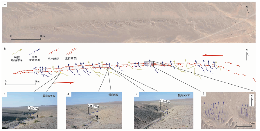
沿主断裂及其西延部分发育了一系列与断裂左旋活动相关的断错微地貌, 包括断错冲沟、 纹沟和山脊等。 之前沿主断裂的调查结果表明, 断裂的水平运动使冲洪积台地上的纹沟发生同步左旋位错, 水平位移量均< 10m(云龙等, 2016a)。 近期的调查发现, 穿越主断裂和党河水库段的个别冲沟, 其断错距离达几十m甚至上百m, 且水平位移量有明显的分级现象。 本文以观察点16-Y04、 16-Y06、 16-Y18和党河水库段(位置见图2a)为例进行介绍。 此外, 在沿阳关镇段开挖的砂场内也发现断层剖面, 本研究也围绕着该剖面进行了相关工作。
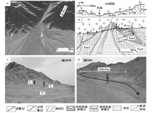
在该点老冲洪积扇Fan2被冲沟侵蚀切割, 在平面上呈倒三角状(图3a, b), 在一条较大冲沟的西岸, 由老冲积扇构成的T1阶地面上分布有2条小冲沟, 分别为冲沟1和冲沟2, 这2条冲沟在断裂通过处发生同步肘状左旋位错, 位错量分别为(29± 3)m和(26± 4)m(图3c, d)。
 | 图 3 观察点16-Y04处的断错地貌 a 该点处的卫星影像(来自Google Earth); b 断裂断错地貌及山前冲洪积扇分期; c、 d 2条断错冲沟地貌Fig. 3 Microgeomorphology at point 16-Y04. |
该点冲沟西岸的Fan1和Fan2上发育2级阶地, 分别为河漫滩(T0)、 T'1、 T1和T2阶地, 上述阶地的拔河高度分别为0.4m、 1.0m、 1.4m和3.1m(图4a, b, d); 冲沟东岸仅发育1级阶地, 分别为河漫滩(T0)和T1阶地, 拔河高度分别为0.4m和1.2m(图4a, b)。 T1和T2阶地的沉积物以冲洪积砂砾石层为主, 砾石多为花岗岩、 片岩和片麻岩, 粒径多为cm级。 在断层通过处, 冲沟西岸的T2阶地在废弃后被断错(26± 2)m, 而发育于该阶地上的小冲沟被断错(28± 4)m。
 | 图 4 观察点16-Y06处的断错地貌 a 该点处的卫星影像(来自Google Earth); b 断错阶地和冲沟; c 阶地分布; d 断错冲沟Fig. 4 Microgeomorphology at point 16-Y06. |
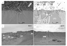
该点断裂的左旋走滑运动对冲沟1和山前的冲洪积扇形态进行了改造(图 5)。 冲沟1被断错之前的流向可能为NNW(图6b中的虚线), 被断错后流向发生了明显变化, 在山体内部由N转为SEE, 在山前发生了近180° 的转向, 随后又转为NW。 冲沟的转向使得冲洪积扇面的形态发生变化, 在与冲沟1规模近似的其它冲沟前缘的冲洪积扇Fan2往往以冲沟为轴近对称分布。 然而在该点, 冲沟1侵蚀了其东岸大部分Fan2地层, 依据影像判别(图5a), 东岸的Fan1形成前也应为Fan2, 而现今仅残留了一小部分(图5a, b)。 断裂的水平运动使冲沟1发生(76± 5)m的左旋位错。 流水侵蚀与搬运形成了1级阶地。 其中, 东岸T'1阶地的拔河高度为4.2m, T1阶地的拔河高度为8.0m; 西岸T1阶地的拔河高度为8.4m(图5c, d)。
 | 图 5 观察点16-Y18处的断错地貌 a 该点处的卫星影像(来自Google Earth); b 断裂断错地貌及山前冲洪积扇分期; c 断错冲沟地貌; d 断错冲沟右岸地貌Fig. 5 Microgeomorphology at point 16-Y18. |
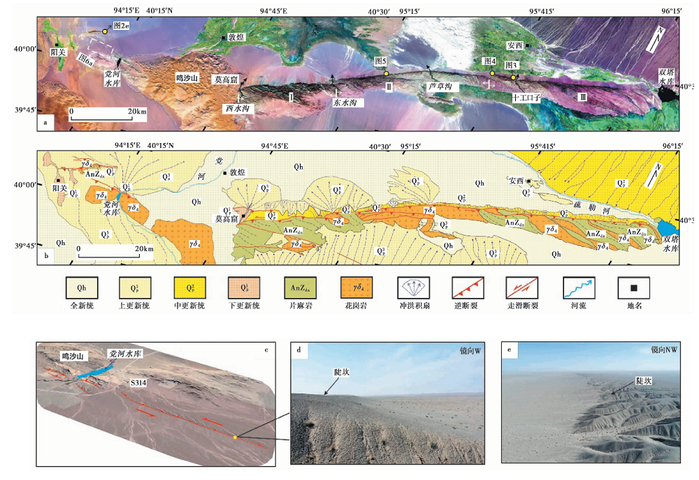
 | 图 6 党河水库西侧冲沟位错分布图 a 党河水库段的卫星影像(来自Google Earth); b 党河水库断裂及位错冲沟解译, 蓝色实线代表实测断错冲沟, 黄色实线代表疑似断错冲沟; c— f 断错冲沟的照片及影像Fig. 6 Microgeomorphology along Danghe Reservoir segment. |
通过卫片解译和野外调查发现, 在断裂通过处, 一系列的冲沟和纹沟发生同步肘状左旋位错(图6a, b), 然而由于降雨和河流的侧蚀作用, 对于一些大型的冲沟, 无法判断河流侵蚀等作用对其后期的改造程度。 因此, 在测量和统计过程中剔除了这些大型冲沟(图6b中的黄色实线), 仅统计了断裂通过处发生明显拐折的34条小型冲沟和纹沟(图6b— f)。
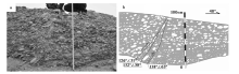
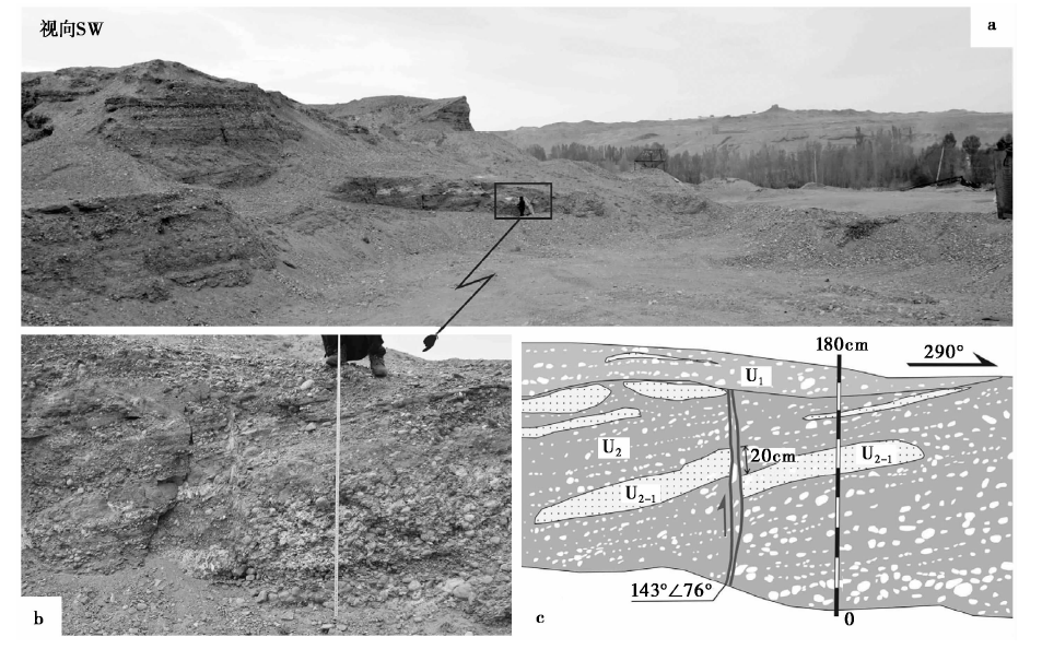
该剖面位于阳关镇段西端、 阳关镇NW约4km处(图2a)。 在采石场处断层陡坎被人工挖开, 剖面内揭露的地层主要以河流相的砂砾石层为主, 有明显的二元结构, 断层延伸进入砂砾石层(图7a)。 在观察点Y33, 剖面内共揭示了2套地层(图7b, c)。 U1: 河流相砾石层, 砾石有一定程度的定向排列。 层内夹有厚1~2cm的细砂透镜体; U2: 河流相砂砾石层, 层内砾石明显呈水平排列, 粒径从1~2cm至8~10cm不等, 砾石层与中粗砂、 细砂层相间排布。 层内局部发育厚3~5cm至约10cm的中砂、 细砂透镜体。 层内发育的断层错断该层, 被U1覆盖, 断层产状为143° ∠76° 。 层内发育一长2.5m、 厚约20cm的细砂透镜体U2-1, 被断层错断, 实测错距约20cm。
 | 图 7 阳关镇西北侧石料厂及Y33点的断层剖面Fig. 7 The fault profile and its interpretation of point Y33 around a stone factory at the northwest of Yangguan Town. |
在石料场内另一观察点Y32处, 剖面内的河流相砾石明显呈水平排布, 砾石层局部夹有中、 粗砂, 砾石的粒径从1~2cm至约10cm不等。 剖面内共揭露出3条断层, 产状分别为126° ∠51° 、 132° ∠58° 和138° ∠63° 。 上述断层错断砾石层, 断层通过处砾石发生明显的顺时针旋转, 扁平面与断层近平行排布(图 8)。
 | 图 8 Y32点的断层剖面Fig. 8 The fault profile and its interpretation of point Y32. |
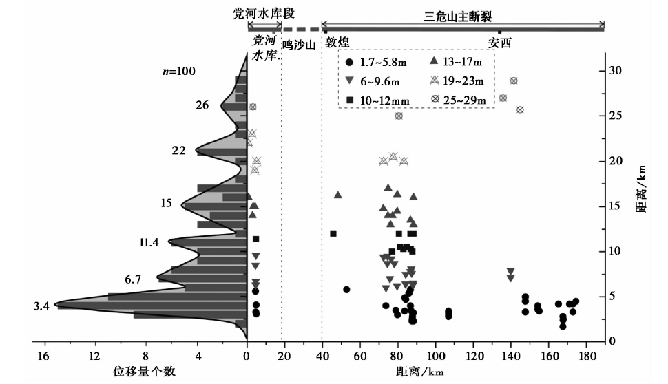
水平位移量的分级现象在鲜水河断裂、 小江断裂、 红河断裂、 西秦岭北缘断裂、 富蕴断裂和天景山断裂均有发现, 反映了断裂本身的某种活动习性(钱洪等, 1990; 向宏发等, 1994; 虢顺民等, 1995; 沈军等, 1997; 李传友等, 2006; Klinger et al., 2011; Li et al., 2017, 2019)。 目前, 对水平位移量进行分级的方法包括依据断错水系的规模(如长度)与位移量的关系(向宏发等, 1994; 虢顺民等, 1995)、 依据某一数值区间内位移量的集中程度(李传友等, 2006)或各级位移值所占比例(沈军等, 1997), 但也不可否认上述方法或多或少均存在人为干扰因素, 因此也需要根据具体情况进行综合分析。 为了进一步分析三危山断裂水平位移量的分布特征, 通过Google Earth卫星图像解译和野外实测共获得123组水平位移量数据。 对于这些数据中位移量> 30m的断错水系(往往对应一些规模较大的冲沟), 一方面由于其数据量较少(23组), 可能不具有统计意义; 另一方面由于无法估计河流侧向侵蚀对这些数据的影响, 以往的研究也表明一些位移量大的数据很不可靠(Klinger et al., 2011), 因此本文将不讨论位移量> 30m的断错水系数据, 而仅筛选出位移量< 30m的100组数据, 利用频率统计的方法进行分析, 结果见图 9。
 | 图 9 沿三危山断裂的水平位移量分级和分布图Fig. 9 The distribution and grouping of horizontal displacements along Sanweishan main fault and its western segments. |
图 9 显示沿三危山主断裂及其西延部分的水平位移量可分为较为明显的6级, 由小到大分别为: Ⅰ 级(41组数据): 位移量1.7~5.8m, 统计曲线峰值为3.4m; Ⅱ 级(21组数据), 位移量6~9.6m, 统计曲线峰值为6.7m; Ⅲ 级(11组数据): 位移量10~12m, 统计曲线峰值为11.4m。 以上3组对应的断错地貌主要为分布于老冲洪积扇面上的纹沟和部分山脊, 纹沟的长度一般< 100m, 宽1~2m。 Ⅳ 级(15组数据): 位移量13~17m, 统计曲线峰值为15m; Ⅴ 级(7组数据): 位移量19~23m, 统计曲线峰值为22m; Ⅵ 级(5组数据): 位移量25~29m, 统计曲线峰值为26m。 与以上3组对应的断错小冲沟, 长度一般为150~300m, 宽约3m。 而对于位移量> 30m的冲沟, 其长度一般为km级, 宽度> 10m。
在野外观测和卫星影像解译中, 都发现沿三危山主断裂及其西延部分规模较大的断错水系(冲沟)对应的水平位移量往往较大, 而纹沟和山脊则相对较小, 即同一条断裂上的位移量与断错水系的规模呈正相关。 位移量的分级结果显示, 各级位移量的增量均保持在3~4m, 说明同一级别内的断错水系在同一时期内形成。 最小一级的位移量峰值可能代表了最新一次古地震的同震位移量, 而更大级别的位移量峰值则可能代表了多次古地震累积的同震位移量。
古地震和构造地貌的研究表明, 大型走滑断裂上发生的多期古地震事件与水平位移量的分级存在对应关系, 如圣安德烈斯断裂(Liu et al., 2004; Zielke et al., 2010)、 富蕴断裂(Klinger et al., 2011; 徐锡伟等, 2012)、 海原断裂(Zhang et al., 2005; Ren et al., 2015)和香山-天景山断裂(Li et al., 2017, 2019)。 三危山断裂的水平位移量也存在类似的分级特征(图 9), 表明沿该断裂发生过多次古地震事件, 而最新一次事件对应的同震位移量为3.4m, 2次古地震之间的位移增量为3~4m。 探槽开挖的结果显示, 沿三危山主断裂的中、 东段发生了3次古地震事件, 分别发生在距今约53ka、 40ka和7.42~2.47ka(云龙等, 2016b)。 对比水平位移量沿断裂的空间分布情况, 最小一级的水平位移量多分布于主断裂的中、 东段, 因此推测3.4m可能代表了7.42~2.47ka BP发生的地震事件的同震位移量。
为了更好地讨论三危山断裂的潜在发震能力, 下面尝试利用震级、 破裂长度和位移量之间的关系恢复最新一次古地震的震级。 一般认为, 强震的地表破裂长度L、 位移量D和震级M存在简单的线性关系:
式中, M为震级, L为断裂破裂长度(km), D为位移量, a和b为一元线性回归系数。
由于公式(3)假设L和D对M的影响相同, 实际却不一定相同, 因此, 采用二元回归关系式(4)代替公式(3)更为合理(邓起东等, 1992; 叶文华等, 1996):
式中, b0、 b1和b2为二元线性回归系数。
综上, 采取公式(1)、 (2)和(4)对三危山断裂中、 东段最新一次古地震的震级进行估算, 根据最小一级位错量的空间分布多集中在中段和东段的特征(图 9), L取中段和东段的长度之和87km, D取3.4m, 估算结果见表1 。
| 表1 古地震震级估算结果 Table1 Estimate magnitude of the latest paleoearthquake |
从估算的结果看, 当假设三危山断裂的中段和东段在最新一次古地震中均发生地表破裂, 估算给出的古地震震级最小值为7.32, 最大值为7.66, 而多数结果集中在7.5~7.6。 阿尔金断裂东段的古地震研究显示, 晚更新世以来, 在青崖子— 宽滩山段发生了多次强震(王峰等, 2002)。 作为阿尔金断裂带东段分支的三危山断裂可能也具备发生强震的能力, 说明三危山断裂在晚更新以来并非已停止活动(张裕明等, 1989)。 其目前的活动性较弱, 可能是因为处于强震的间震期内(Cunningham et al., 2016)。
目前已有的穿越三危山断裂、 南截山断裂和阿尔金断裂的大地电磁剖面(Xiao et al., 2011, 2015)和地震反射剖面(陈干, 2018)显示, 三危山断裂在深部有向阿尔金断裂收敛的趋势, 构成了阿尔金断裂的分支断裂, 三者共同构成了区域性非对称半花状构造(Cunningham et al., 2016)。 伴随着青藏高原的NE向扩展, 高原对阿尔金断裂北侧的敦煌地块存在侧向挤压和水平拖拽作用(即transpression, 压剪作用), 而这种压剪作用造成了三危山和南截山的隆升(李海兵等, 2004), 但目前二者隆升的先后顺序尚不确定; 而水平拖拽作用导致夹持于阿尔金断裂和三危山断裂之间的块体发生了NEE向的水平运动(GPS速度场)(Wang et al., 2001; Zhang et al., 2004)。 作为块体的北边界, 三危山断裂的左旋走滑协调并吸收了块体的水平运动。
三危山断裂的位移量分布特征、 断裂端部的构造转换等特征显示其类似一个小型的阿尔金断裂, 其发育和发展可能代表了阿尔金断裂的早期阶段, 同时也反映出青藏高原北缘的生长是通过与阿尔金断裂平行的断裂的活动而向N扩展, 而东北缘的生长则是通过阿尔金断裂应变分解到一系列逆冲推覆构造而实现的。 因此, 高原北缘的生长在不同段上的机制和表现并不一致, 但都与走滑断裂的活动有关。
本文通过对三危山主断裂及其西延部分断错地貌的实地调查和水平位移量的统计分析, 取得了以下认识:
(1)以往的三危山断裂仅指三危山山前的一段, 通过卫片解译和野外实地调查发现, 断裂穿过鸣沙山后, 西延至党河水库及阳关镇附近, 以断层陡坎的形式出露地表, 西延范围> 60km(主断裂长150km), 说明该断裂的空间延伸规模远比之前认识的大。
(2)三危山断裂的左旋水平运动使一系列跨越断裂的水系(冲沟和纹沟)和山脊发生同步位错, 断错水系的规模与水平位移量正相关。
(3)沿三危山断裂分布的水平位移量具有明显的分级特征, 可分为6级, 各级别的峰值分别为3.4m、 6.7m、 11.4m、 15m、 22m和26m, 各级之间的位移增量为3~4m, 说明断裂在晚第四纪以来有过多期次的地震活动, 具有特征型地震的活动特点, 具备再次发生7级以上地震的可能性。
谨以此文纪念马瑾院士。 马瑾先生正派的学风, 脚踏实地、 严谨求实、 兴致勃勃的科研精神值得我们一生学习。
致谢 中国地震局地质研究所陈立春研究员为本文提出了许多建议; 作者与中国地震局地震预测研究所孙鑫哲博士和中国地震局地质研究所李新男博士进行了有益的讨论; 审稿专家为本文提出了中肯的意见和建议。 在此一并表示感谢!
| [1] |
|
| [2] |
|
| [3] |
|
| [4] |
|
| [5] |
|
| [6] |
|
| [7] |
|
| [8] |
|
| [9] |
|
| [10] |
|
| [11] |
|
| [12] |
|
| [13] |
|
| [14] |
|
| [15] |
|
| [16] |
|
| [17] |
|
| [18] |
|
| [19] |
|
| [20] |
|
| [21] |
|
| [22] |
|
| [23] |
|
| [24] |
|
| [25] |
|
| [26] |
|
| [27] |
|
| [28] |
|
| [29] |
|
| [30] |
|
| [31] |
|
| [32] |
|
| [33] |
|
| [34] |
|
| [35] |
|
| [36] |
|
| [37] |
|
| [38] |
|
| [39] |
|
| [40] |
|
| [41] |
|
| [42] |
|
| [43] |
|
| [44] |
|
| [45] |
|