青海都兰热水-桃斯托河断裂的新发现及构造意义
[李智敏1, 3)  , 任治坤
, 任治坤2), * , 刘金瑞2) , 哈广浩2) , 李正芳2) , 王勃1) , 王林建3) ]
, 任治坤, 刘金瑞|
|


〔作者简介〕 李智敏, 男, 1977年生, 2005年于中国地震局兰州地震研究所获构造地质专业硕士学位, 副研究员, 现主要从事活动构造及其次生灾害方面的研究工作, 电话: 0755-82616372, E-mail: minhero_168@126.com。
在青海都兰最新开展的活动断裂调查工作中, 于都兰-茶卡高地南部新发现了1条长约40km、 走向近NEE的左旋走滑、 局部兼正断性质的全新世活动断裂——热水-桃斯托河断裂。 文中通过野外地质调查与典型段落无人机航拍主要获得了以下2点认识: 1)热水-桃斯托河断裂及其全新世活动的发现尚属首次, 其长约40km, 断裂带东端存在长6km的地表破裂带; 2)断裂切过的冲沟和阶地存在左旋位错现象, 利用无人机获取高分辨率DEM影像, 并对冲沟沟谷的地形剖面进行恢复测量得到的位错量为(9.3±0.5)m、 (17.9±1.5)m和(36.8±2)m。 对2级冲沟阶地位错进行恢复测量得到T1/T0阶地陡坎的位错量为(18.2±1.5)m, T2/T1阶地陡坎的位错量为(35.8±2)m, 可以看出冲沟位错量和阶地位错量的结果较为一致。 据历史地震记载, 1938年4月10日在热水-桃斯托河断裂地表破裂的东端发生了 M53/4地震, 1952年3月21日发生了 MS5.0地震, 可能均与该断裂的活动有关。 但在都兰县县志等相关资料中均未发现有关于这2次地震的文献记录, 这可能与当时地震震中比较偏远、 都兰县人口稀少且发震时间比较久远有关。 东昆仑断裂和鄂拉山断裂最南端会聚形成1个向NW挤出的楔形断块, 位于楔形断块端部的都兰盆地受区域NE-SW向主压应力和2条边界断裂剪切作用的影响, 经历了挤压伴随局部拉张的复杂变形过程。 这主要是由于2条控制楔形断块的边界断裂——东昆仑断裂与鄂拉山断裂之间存在NE-SW向的挤压作用, 在这样的挤压过程中, 楔形断块局部拉张的具体表现形式为两侧断裂发生走滑, 使断块向NW向挤出, 因此该区三角楔形挤出的变形机制与纯粹的刚性块体的挤出机制有所不同。 在靠近鄂拉山断裂的都兰盆地东北缘形成一系列向SE会聚的羽列状逆冲断裂, 其形态上向E与鄂拉山断裂平行, 可能在深部汇入鄂拉山断裂; 靠近东昆仑断裂带的都兰盆地南缘断裂, 即热水-桃斯托河断裂受到东昆仑左旋走滑断裂和鄂拉山右旋走滑断裂共同作用的影响, 表现为左旋走滑的活动特征, 同时楔形断块向NW挤出, 使其东南端出现局部拉张, 故断层局部又表现为拉张性质。 这些断裂共同吸收或转换高原东北缘的剪切应力。 因此, 此次对都兰热水-桃斯托河断裂的新发现为更好地认识和理解青藏高原东北部断块内部的变形方式和机制等提供了重要的约束条件和依据。
, REN Zhi-kun, LIU Jin-ruiThe 40km-long, NEE trending Reshui-Taostuo River Fault was found in the southern Dulan-Chaka highland by recent field investigation, which is a strike-slip fault with some normal component. DEM data was generated by small unmanned aerial vehicle(UAV)on key geomorphic units with resolution<0.05m. Based on the interpretation and field investigation, we get two conclusions: 1)It is the first time to define the Reshui-Taostuo River Fault, and the fault is 40km long with a 6km-long surface rupture; 2)There are left-handed dislocations in the gullies and terraces cut by the fault. On the high-resolution DEM image obtained by UAV, the offsets are(9.3±0.5)m, (17.9±1.5)m, and(36.8±2)m, measured by topographic profile recovery of gullies. The recovery measurements of two terraces present that the horizontal offset of T1/T0 is(18.2±1.5)m and the T2/T1 is (35.8±2)m, which is consistent with the offsets from gullies. According to the historical earthquake records, a M53/4 earthquake on April 10, 1938 and a MS5.0 earthquake on March 21, 1952 occurred at the eastern end of the surface rupture, which may be related to the activity of the fault. By checking the county records of Dulan and other relevant data, we find that there are no literature records about the two earthquakes, which is possibly due to the far distance to the epicenter at that time, the scarcity of population in Dulan, or that the earthquake occurred too long ago that led to losing its records. The southernmost ends of the Eastern Kunlun Fault and the Elashan Fault converge to form a wedge-shaped extruded fault block toward the northwest. The Dulan Basin, located at the end of the wedge-shaped fault block, is affected by regional NE and SW principal compressive stress and the shear stress of the two boundary faults. The Dulan Basin experienced a complex deformation process of compression accompanying with extension. In the process of extrusion, the specific form of extension is the strike-slip faults at each side of the wedge, and there is indeed a north-east and south-west compression between the two controlling wedge-shaped fault block boundary faults, the Eastern Kunlun and Elashan Faults. The inferred mechanism of triangular wedge extrusion deformation in this area is quite different from the pure rigid extrusion model. Therefore, Dulan Basin is a wedge-shaped block sandwiched between the two large-scale strike-slip faults. Due to the compression of the northeast and southwest directions of the region, the peripheral faults of the Dulan Basin form a series of southeast converging plume thrust faults on the northeast edge of the basin near the Elashan Fault, which are parallel to the Elashan Fault in morphology and may converge with the Elashan Fault in subsurface. The southern marginal fault of the Dulan Basin(Reshui-Taostuo River Fault)near the Eastern Kunlun fault zone is jointly affected by the left-lateral strike-slip Eastern Kunlun Fault and the right-lateral strike-slip Elashan Fault, presenting a left-lateral strike-slip characteristic. Meanwhile, the wedge-shaped fault block extrudes to the northwest, causing local extension at the southeast end, and the fault shows the extensional deformation. These faults absorb or transform the shear stress in the northeastern margin of the Tibet Plateau. Therefore, our discovery of the Dulan Reshui-Taostuo River Fault provides important constraints for better understanding of the internal deformation mode and mechanism of the fault block in the northeastern Tibetan plateau.
The strike of Reshui-Taostuo River Fault is different from the southern marginal fault of the Qaidam Basin. The Qaidam south marginal burial fault is the boundary fault between the Qaidam Basin and the East Kunlun structural belt, with a total length of ~500km. The geophysical data show that Qaidam south marginal burial fault forms at the boundary between the positive gravity anomaly of the southern East Kunlun structural belt and the negative gravity anomaly gradient zone of the northern Qaidam Basin, showing as a thrust fault towards the basin. The western segment of the fault was active at late Pleistocene, and the eastern segment near Dulan County was active at early-middle Pleistocene. The Reshui-Taostuo River Fault is characterized by sinistral strike-slip with a normal component. The field evidence indicates that the latest active period of this fault was Holocene, with a total length of only 40km. Neither remote sensing image interpretation nor field investigation indicate the fault extends further westward and intersects with the Qaidam south marginal burial fault. Moreover, it shows that its strike is relatively consistent with the East Kunlun fault zone in spatial distribution and has a certain angle with the burial fault in the southern margin of Qaidam Basin. Therefore, there is no structural connection between the Reshui-Taostuo River Fault and the Qaidam south marginal burial fault.
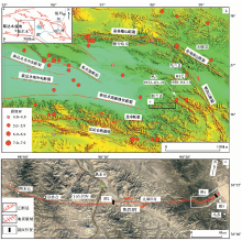
青藏高原东北缘是由NEE向的阿尔金断裂带、 NWW向的海原-祁连山断裂带和NWW向的东昆仑断裂带等3条巨型左旋走滑断裂所围限的活动地块(袁道阳等, 2004), 同时也是青藏高原向外扩展的最前缘, 是对整个高原隆升和变形最敏感的地区之一。 该块体内构造变形强烈, 发育大量褶皱、 逆冲和走滑断裂, 表明该区正经历地壳缩短、 左旋剪切并伴随垂直隆升变形(邓起东等, 2002, 2004, 2008; 张培震等, 2006, 2013)。 多年来, 国内外学者围绕本区的边界断裂— — 阿尔金断裂(付碧宏等, 2006)、 海原-祁连断裂带和东昆仑断裂带以及主要次级构造— — 鄂拉山断裂和日月山断裂等开展了大量研究工作(袁道阳等, 2003a, b; 徐锡伟等, 2007; 郑文俊, 2009; Yuan et al., 2011; 郑文俊等, 2012; 李智敏等, 2013, 2018, 2019; Ren et al., 2015), 在滑动速率、 构造变形样式和古地震事件等领域均获得了丰富的成果。 但目前对青藏高原东北缘内部次级构造块体间的构造转换关系开展的研究并不多, 特别是针对NWW向的东昆仑断裂和NNW向的鄂拉山断裂之间的相互转换研究较少, 在东昆仑断裂和鄂拉山断裂交会的楔形区域内应力如何通过其间的次级断层进行转化的问题也仍未得到确切解答。
在近期开展的都兰活动断裂调查中, 于都兰-茶卡高地南部新发现了1条长约40km、 走向近NEE的左旋走滑兼局部正断性质的全新世活动断裂— — 热水-桃斯托河断裂, 该断裂具有全新世活动现象。 该新发现不仅为认识都兰盆地的变形样式提供重要依据, 同时能为认识和理解青藏高原东北部断块内部的变形方式和机制等提供重要的约束条件和依据。
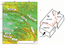
研究区都兰-茶卡高地周缘发育有2条非常显著的大型走滑断裂— — NWW向的东昆仑左旋走滑断裂和NNW向的鄂拉山右旋走滑断裂。 这2条断裂分别为都兰-茶卡高地的南、 北边界, 前者东端和后者最南端会聚形成1个向NW挤出的楔形断块, 都兰盆地则位于这2条大型走滑断裂所夹持的楔形断块内(图1b)。 盆地北侧及东侧形成了一系列向SE会聚的羽列状逆冲断裂, 前人研究认为, 这一系列右阶羽列的逆冲断裂是鄂拉山显著的右旋走滑活动的结果(Wang et al., 2004)。 鄂拉山右旋走滑断裂和日月山右旋走滑断裂被认为是夹持在海原-祁连断裂和东昆仑左旋主边界断裂之间的右旋次级构造, 通过顺时针旋转和书斜构造运动方式或多米诺断块模式共同吸收或转换高原东北缘NWW向的区域性左旋剪切变形(Duvall et al., 2010)。 因此, 都兰盆地周缘断裂的晚第四纪构造活动和变形方式应该与东昆仑断裂和鄂拉山断裂区域性走滑变形存在密切的成因联系。
 | 图 1 研究区区域地震构造图Fig. 1 Seismotectonic map of the study area. |
通过新的遥感解译和野外实地调查, 在都兰-茶卡高地南部新发现1条晚第四纪以来左旋走滑的活动断裂— — 热水-桃斯托河断裂。 该断裂起始于都兰县热水乡西, 自西向东经过阿木它西、 尕洛合、 白石岩沟、 智尕日村、 扎麻日村和乌苏北, 长约40km, 走向近NEE(图1c), 并在该断裂的东端发现长约6km的地震破裂带。 本文重点对此次新发现的热水-桃斯托河断裂的晚第四纪活动性及地震地表破裂特征进行分析, 希望为更好地认识都兰断块区最新的地壳变形方式及未来强震危险性等提供新的证据。
基于Google Earth在线影像数据、 无人机航测以及野外地质地貌调查, 本文对研究区晚第四纪以来的构造地貌单元进行了定量解译。 目前活动构造研究的前沿方向为利用高精度LiDAR数据生成DEM、 无人机航测影像生成DEM、 高分辨率卫星影像立体像对生成DEM等分析沿断裂的三维位错特征, 前人的研究表明其在活动构造定量化研究中具有广泛的应用前景(Wang et al., 2011; Ren et al., 2015, 2018)。 本研究利用无人机对关键地貌单元进行航测, 生成了分辨率高于0.05m的DEM数据, 其垂直精度为10~15cm。 基于该高分辨率DEM数据进行了沿断裂的地貌面划分及其变形量分析, 为判定断裂活动性提供了重要的数据基础。
地貌面的划分主要依据地貌面的分布高度、 残存的规模、 延伸方向以及地貌面序列特征等(苏鹏等, 2016), 水平距离则基于无人机航测得到的DEM数据进行测量。 由于河流阶地形成后, 其前缘还会受到河流的侧蚀, 故阶地前缘的位错量往往不能代表该级阶地被废弃以来的断错量。 但通过多条同级水系位错量的对比, 发现在该研究区河流的侧蚀对断层的位错量影响不大。 因此, 本文以河流阶地面前缘和后缘的位错量代表该级阶地面被废弃以来的位错量。
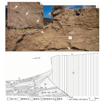
在智尕日村西1.3km处的桃斯托河南岸, 冲沟自南向西流入桃斯托河。 该冲沟发育2级阶地, 其中Ⅰ 级阶地T1拔河约2m, Ⅱ 级阶地T2拔河约3.5m, 在冲沟西壁可见热水-桃斯河断层的迹象。 对沟壁剖面的清理结果显示, 该断层具有走滑活动特征(图2), 断层东盘为厚层黄土, 西盘为阶地堆积, 沿断层滑动面有砾石定向排列, 断层产状为45° /NNW∠45° (视倾角)。 剖面地层描述如下:
①T2阶地较厚黄土层, 分选较好, 有一定水平层理;
②T1阶地顶部砾石层, 分选、 磨圆较差, 有个别较大砾石, 厚度不均一, 层理倾斜;
③T1阶地细砂层, 层理向河道一侧倾斜, 分选、 磨圆较好;
④T2阶地黄土层, 被T1阶地盖住, 中间夹小砾石透镜体;
⑤T2阶地底部砾石层, 磨圆中等, 分选较差, 夹个别大砾石, 厚度不均一;
⑥细砂层, 水平层理, 底部夹较大砾石, 于其内采集光释光样品, 编号为DL-OSL-20;
⑦底部砾石层, 与上层相比砾石的粒径较小, 分选、 磨圆中等, 仅在断层一侧分布;
⑧细砂崩积楔, 中间夹一较大砾石, 层理倾斜, 为断裂活动所致。
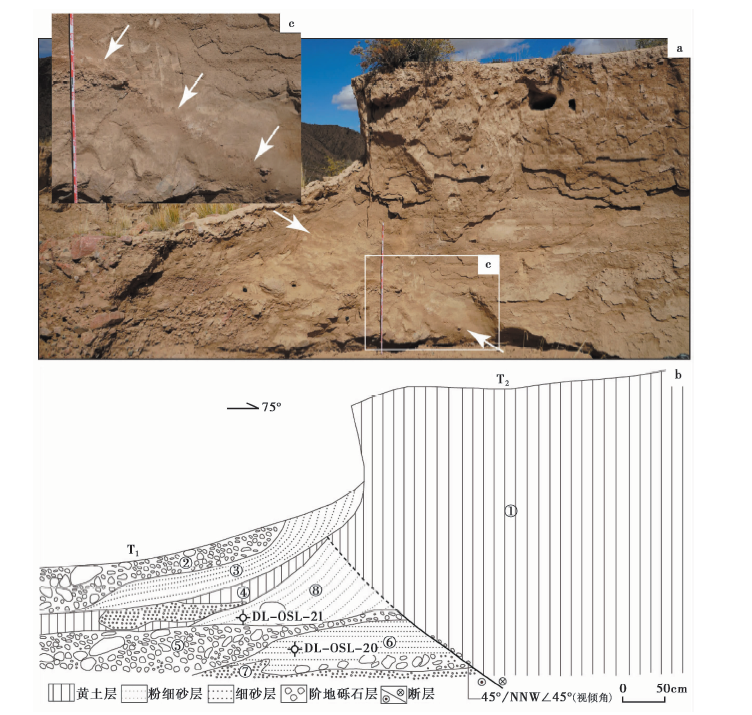 | 图 2 智尕日村西断层剖面Fig. 2 Fault section at west of Zhigari village. |
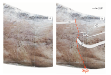
在热水-桃斯河断裂东端的桃斯托河以西, 断层活动形成长约6km的地表破裂带, 在地表破裂断塞塘明显的位置开挖了剖面(图3), 揭示断层具有正断性质, 剖面顶部的黑色条带层①断错约20cm, 可能代表断层的最新一次活动。
 | 图 3 桃斯托河以西断层剖面 灰色条带为断层断错标志层Fig. 3 Fault section west of Taostuo River. |
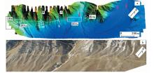
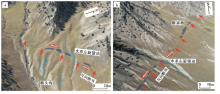
热水-桃斯托河断裂东部的桃斯托河虽然地处高海拔地区, 但断裂通过处的地势起伏相对平缓, 晚第四纪冲积相堆积物得到了较好保存。 我们在该地区发现了近6km长的地表破裂, 借助无人机航测得到的DEM数据影像对地表破裂的展布和地貌位错量等进行了更精细的定量研究(图4, 位置见图1)。
 | 图 4 热水-桃斯托断裂西端地表破裂 a 无人机DEM地貌图; b 无人机斜射地貌图Fig. 4 Surface rupture at western end of Reshui-Taostuo River Fault. |
在DEM影像上, 断层发生走滑活动并在山前冲洪积扇体上形成宽4~5m的地表破裂带, 破裂带长约6km, 线性特征明显, 沿破裂带发育一系列断塞塘(图5)。 这些断塞塘沿断裂呈串珠状分布, 单个长数十米, 宽2~5m, 由于冲沟的侵蚀作用, 鼓包不明显, 冲沟沟壁由于断层的左旋错动沿断层形成反向坎(图4b)。
 | 图 5 沿着地表破裂发育的断塞塘Fig. 5 Sag ponds developed along the surface rupture. |
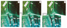
断层切过由北向南流动的冲沟A和B(图4), 这2条冲沟的规模较小, 阶地不很发育, 冲沟A、 B的沟床宽度在断裂的上游与下游基本一致, 表明流水对冲沟沟壁并未产生明显的冲刷侵蚀作用, 这可能是因为研究地区气候干旱, A、 B冲沟临近分水岭地带, 上游汇水盆地较小, 冲沟中水量较少所致。 我们在研究地区的实地考察中也发现, 7— 9月雨季时A、 B冲沟中仅有很小的细流, 这可能不足以对冲沟沟壁产生较大的侵蚀作用。 通过该地区的无人机航测高精度DEM影像对2支冲沟A、 B进行位错恢复(图 6, 图7), 结果显示冲沟A的左旋位错量为(17.9± 1.5)m; 冲沟B有2期左旋位错, 形成断头沟, 一期的左旋位错量为(9.3± 0.5)m, 另一期为(36.8± 2)m。
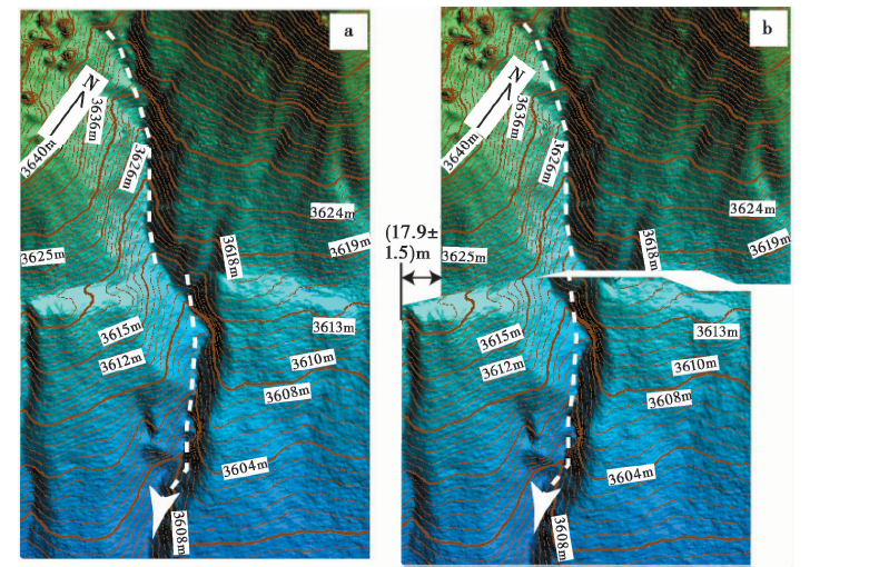 | 图 6 冲沟A左旋位错图及其恢复图 a 原始地貌图; b 1次位错恢复图Fig. 6 Left-lateral offset of gully A and its recovery. |
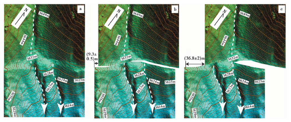 | 图 7 冲沟B左旋位错图及其恢复图 a 原始地貌图; b 1次位错恢复图; c 2次位错恢复图Fig. 7 Left-lateral offset of gully B and its recovery. |
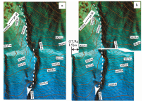
在破裂带的西端(图8, 位置见图4)发育由西向东流动的规模较大的冲沟, 冲沟宽约40m, 对阶地陡坎和阶地面的保存程度、 阶地的相对高度进行分析, 在断裂上、 下游的左岸可分出2级冲洪积阶地, 阶地陡坎保存完好, 陡坎坡度较陡, 与断裂的交点清晰, 阶地范围易于识别, 说明因长期来自山坡的流水对陡坎的侵蚀作用较弱, 陡坎保存相对较好。 在无人机航测高精度DEM影像中对各级阶地陡坎进行位错恢复测量(图8), 考虑到DEM影像的分辨率(0.05m)以及阶地陡坎与断裂交点的清晰程度, 测得T1/T0阶地陡坎、 T2/T1阶地陡坎的位错量分别为(18.2± 1.5)m和(35.8± 2)m。
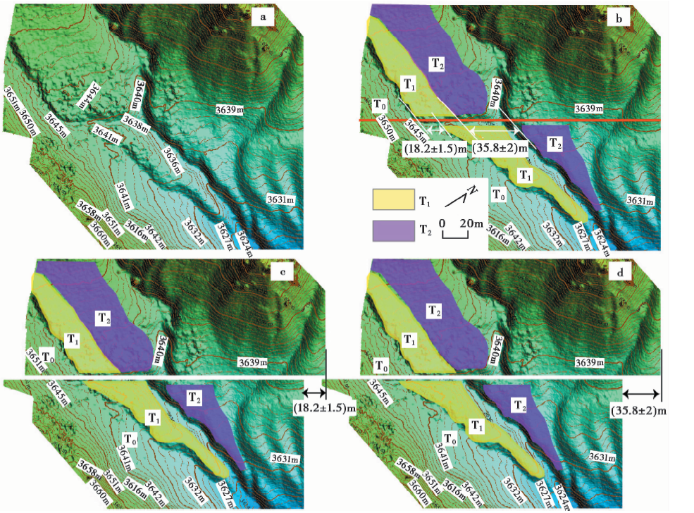 | 图 8 断错地貌解译及位错恢复图 a 原始地貌图; b 断错地貌解译图; c T1阶地位错恢复图; d T2阶地位错恢复图Fig. 8 Interpretation of fault geomorphology and its recovery. |
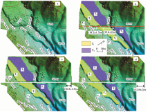
晚新生代以来, 随着印度板块持续向N推挤, 整个青藏高原尤其是东北缘地区的构造变形主要以NE向的地壳缩短、 顺时针方向旋转为主, 实现不同方向与不同性质的活动构造之间的转换平衡(张培震等, 2003; 郑文俊等, 2016)。 NE向的挤压作用导致应变被分解为沿NWW向断裂的左旋走滑运动和沿NNW向断裂的右旋走滑运动, 形成1对共轭的剪切断裂, 导致地壳缩短, 使NWW走向的断裂具有很大的逆冲分量, 造成块体内部发生剪切压扁(袁道阳等, 2004)。 青藏高原东北缘的东昆仑断裂是1条NWW向的巨型左旋走滑断裂, 其控制了巴颜喀拉块体和柴达木-祁连块体的边界, 断裂带中西段总体上具有稳定、 均一的滑动速率, 为10~13mm/a(青海省地震局等, 1999; 杨顺虎等, 2012), 但滑动速率自阿尼玛卿山向E逐渐减小(Kirby et al., 2007; Harkins et al., 2008, 2010; 李陈侠等, 2011), 至最东段的塔藏断裂则降为1.4~3.2mm/a(Ren et al., 2013), 其与鄂拉山断裂东端相交处的滑动速率达10mm/a(Van Der Woerd et al., 2000, 2002; Tapponnier et al., 2001)。 鄂拉山断裂是青藏高原东北缘控制柴达木盆地和祁连活动地块的1条NNW向右旋走滑活动断裂(袁道阳等, 2004), 滑动速率约1.1mm/a(Yuan et al., 2011)(图9a)。
 | 图9 研究区主要活动断层分布及其滑动速率(a)及热水-桃斯托河断裂成因机制(b)Fig. 9 Major active faults and corresponding slip rates(a)and formation mechanism of Reshui-Taostuo River Fault(b). |
青藏高原东缘晚新生代构造变形模式及其动力学假说是国际地学界广泛关注的热点问题。 目前, “ 大陆逃逸” (Tapponnier et al., 1982, 2001; Avouac et al., 1993)和 “ 地壳压缩增厚” (England et al., 1997, 2005)学说成为2种端元模型。 大型断裂沿线并非都处于拉张状态, 也有挤压形式的构造变形。
东昆仑断裂和鄂拉山断裂最南端会聚形成1个向NW挤出的楔形断块(图9b), 位于楔形断块端部的都兰盆地受区域NE-SW向主压应力和2条边界断裂剪切作用的影响, 经历了挤压伴随局部拉张的复杂变形过程。 这主要是由于2条控制楔形断块的边界断裂— — 东昆仑断裂与鄂拉山断裂之间存在NE-SW向的挤压作用, 在这样的挤压过程中, 楔形断块局部拉张的具体表现形式为两侧断裂发生走滑, 使断块向NW挤出, 这可能就是该地区三角楔形挤出变形的机制, 与纯粹的刚性块体的挤出机制有所不同。 都兰盆地是被夹持在这2条大型走滑断裂之间的楔形断块, 其周缘断裂受区域NE-SW向的挤压作用, 在靠近鄂拉山断裂的盆地东北缘形成一系列向SE会聚的羽列状逆冲断裂, 在形态上向E与鄂拉山断裂平行, 可能在深部汇入鄂拉山断裂(Duvall et al., 2013); 靠近东昆仑断裂带的都兰盆地南缘断裂(热水-桃斯托河断裂)受到东昆仑左旋走滑断裂和鄂拉山右旋走滑断裂共同作用的影响, 表现出左旋走滑的特征, 同时由于楔形断块向NW挤出, 致使其东南端出现局部拉张, 断层局部也表现为拉张性质。 这些断裂共同吸收或转换青藏高原东北缘的剪切应力(图9b)。
从空间展布来看, 热水-桃斯托河断裂并非在柴达木盆地南缘隐伏断裂走向的延长线上。 柴达木盆地南缘隐伏断裂为柴达木盆地与东昆仑构造带的分界断裂, 全长约500km, 物探资料显示柴达木盆地南缘隐伏断裂构成了南侧东昆仑构造带正重力异常和北部柴达木盆地负重力异常梯度带的分界线, 表现为向盆地方向挤出的逆冲断层, 该断裂西段在晚更新世有过活动, 靠近都兰县的东段在早、 中更新世有过活动。 热水-桃斯托河断裂具有左旋走滑特征, 局部兼具正断性质, 野外证据表明其最新活动时代为全新世, 断裂规模小, 全长仅40km, 遥感影像解译和野外调查都没有发现该断裂向W延伸与柴达木盆地南缘隐伏断裂相交的证据, 在空间展布上其走向与东昆仑断裂带较为一致, 与柴达木盆地南缘隐伏断裂有一定的夹角。 由此可见, 热水-桃斯托河断裂和柴达木南缘隐伏断裂在成因上没有构造联系。
热水-桃斯托河断裂是都兰盆地南缘新发现的1条全新世活动断裂。 对三角楔形挤出断块— — 都兰盆地周缘的断裂活动特征进行研究, 将为探索青藏高原东北缘主边界断裂的活动特征提供重要的约束条件和依据, 因此有必要对该地区进行更深入的活动断裂普查, 并针对热水-桃斯托河断裂的滑动速率、 古地震期次等开展更深入的定量研究工作。
本文利用青海省都兰县热水-桃斯托河断裂断错地貌较为典型地区的野外地质调查结果, 并在高分辨率DEM上进行断错地貌位错分析和位错量恢复测量, 得到以下几点认识:
(1)热水-桃斯托河断裂的发现尚属首次, 该断裂长约40km, 在断裂带东端存在长6km的地表破裂带。
(2)断裂切过的冲沟和阶地存在左旋位错现象, 在利用无人机获取的高分辨率DEM影像上对冲沟沟谷的地形剖面进行恢复测量得到的水平位错量为(9.3± 0.5)m、 (17.9± 1.5)m和(36.8± 2)m。 对2级冲沟阶地进行位错恢复测量得到T1/T0阶地陡坎的位错量为(18.2± 1.5)m, T2/T1阶地陡坎的位错量为(35.8± 2)m。 冲沟位错量和阶地位错量均揭示了热水-桃斯托河断裂的长期活动历史。
(3)位于东昆仑断裂带和鄂拉山断裂所围限的剪切三角地带的热水-桃斯托河断裂, 受到东昆仑断裂左旋走滑和鄂拉山断裂右旋走滑共同的剪切作用影响, 靠近东昆仑断裂带的热水-桃斯托河断裂表现为左旋走滑兼局部正断性质的特征, 与其东南一系列与鄂拉山断裂有构造成因关系的羽列状逆冲断裂共同吸收或转换高原东北缘的剪切应力。
据历史地震记载, 在热水-桃斯托河断裂地表破裂东端发生过2次地震事件, 分别为1938年4月10日的M53/4地震和1952年3月21日的MS5.0地震, 推测可能与热水-桃斯托河断裂的活动有关。 但是由于年代较远, 当时的台站记录稀少, 缺少可用的震源机制解数据。 未来将进一步搜寻更多地震记录和断层擦痕等数据, 以便更准确地限定其发震断裂。
致谢 中国地震局地震预测研究所田勤俭研究员、 中国地震局地壳应力研究所张世民研究员、 青海省地震局屠泓为副研究员对该工作进行了有益讨论; 野外工作中得到都兰县审计局赵媛萍局长、 都兰县地震局马晓军局长和都兰地震台高慧慧台长的协助; 审稿专家对论文提出了宝贵的修改意见。 在此一并表示感谢!
| [1] |
|
| [2] |
|
| [3] |
|
| [4] |
|
| [5] |
|
| [6] |
|
| [7] |
|
| [8] |
|
| [9] |
|
| [10] |
|
| [11] |
|
| [12] |
|
| [13] |
|
| [14] |
|
| [15] |
|
| [16] |
|
| [17] |
|
| [18] |
|
| [19] |
|
| [20] |
|
| [21] |
|
| [22] |
|
| [23] |
|
| [24] |
|
| [25] |
|
| [26] |
|
| [27] |
|
| [28] |
|
| [29] |
|
| [30] |
|
| [31] |
|
| [32] |
|
| [33] |
|
| [34] |
|
| [35] |
|
| [36] |
|
| [37] |
|
| [38] |
|
| [39] |
|