宜昌砾石层石英Ti-Li心ESR年龄及其对三峡贯通时限的指示
魏传义1,2), 刘春茹2), 李长安1,3),*, 尹功明2), 韩非2), 张岱1), 李亚伟1), 张玉芬4)
1) 中国地质大学(武汉), 地球科学学院, 武汉 430074
2) 中国地震局地质研究所, 北京 100029
3) 生物地质与环境地质国家重点实验室, 武汉 430074
4) 中国地质大学(武汉), 地球物理与空间信息学院, 武汉 430074
*通讯作者: 李长安, 男, 教授, E-mail: chanli@cug.edu.cn

〔作者简介〕 魏传义, 男, 1990生, 2019年于中国地质大学(武汉)获第四纪地质学专业博士学位, 中国地震局地质研究所博士后, 现主要从事新构造年代学与物源示踪研究工作, E-mail: chuanyiwei@ies.ac.cn

摘要

江汉盆地是长江贯通三峡后的第一个卸载盆地。 前人的研究表明堆积于江汉盆地西缘的宜昌砾石层是三峡贯通后的直接沉积地层, 因此, 宜昌砾石层堆积的下限年龄可为长江贯通三峡提供重要的年代约束。 但传统的相对年代学方法研究在宜昌砾石层中难以取得较好的成果。 因此, 直接对快速堆积的宜昌砾石层的形成年代和时间跨度开展年代学研究就需要寻找一种更可靠的绝对测年方法, 同时这也是现有研究中的一个重点和难点。 据此, 文中在宜昌砾石层最具代表性的3个连续的沉积剖面上自上而下系统地采集了8个厚层砂质透镜体样品, 采用石英Ti-Li心ESR测年方法对其堆积年代和地层时代跨度进行研究。 结果显示: 宜昌砾石层堆积的年代下限约1.12Ma BP, 上限约0.73Ma BP, 为早更新世晚期到中更新早期约0.4Ma的沉积层。 结合前人的物源示踪结果, 分析认为至少在1.12Ma BP之前长江就已经贯通三峡。

关键词: 江汉盆地; 宜昌砾石层; 石英; Ti-Li心; ESR法测年; 三峡贯通
中图分类号:P597 文献标志码:A 文章编号:0253-4967(2020)01-0065-14
CHRONOLOGY OF YICHANG GRAVEL LAYER BASED ON QUARTZ TI-LI CENTER ESR DATING AND ITS IMPLICATIONS FOR THE INCISION TIMING OF THE THREE GORGES VALLEY
WEI Chuan-yi1,2), LIU Chun-ru2), LI Chang-an1,3), YIN Gong-ming2), HAN Fei2), ZHANG Dai1), LI Ya-wei1), ZHANG Yu-fen4)
1) School of Earth Sciences, China University of Geosciences, Wuhan 430074, China
2) Institute of Geology, China Earthquake Administration, Beijing 100029, China
3) State Key Laboratory of Biogeology and Environmental Geology, Wuhan 430074, China
4) Institute of Geophysics and Geomatics, China University of Geosciences, Wuhan 430074, China
Abstract

Uplift of Tibet Plateau and formation of Asian Monsoon greatly affect East Asian geomorphological evolution, climate change and environment systems. Thus, those phenomena also control the origin, size and direction of river systems. The Yangtze River, as the most important linkage between Tibet Plateau and the East Asian marginal seas, delivers large volumes of water, sediment, and associated chemicals from its headwater regions and tributaries to the East China Sea, significantly influencing sedimentary system evolution in its drainage basin. Therefore, the formation of the modern Yangtze River and its geological-time evolution history have been paid more and more attention to since the beginning of the last century. After debated for more than a century, the First Bend in Shigu area and the Three Gorges have been known as the key capture point of the Yangtze River’s evolution history. In particularly, the Three Gorges incision period remains greatly controversial, which mainly focuses on Cretaceous period-Neogene period, early Pleistocene period, and late Quaternary period.
The Yichang Gravel, just located downstream and outlet of the Three Gorges with an inverted triangle shape, is mainly distributed in western Jianghan Basin with over 1 000km2. Because of its wide distribution and key geographical location, many typical profiles of Yichang Gravel have been the critical materials for studies on stratigraphic division, geomorphic evolution, and paleoenvironment change in middle Yangtze River Basin, especially on the Three Gorges incision history. Based on the previous field investigation, the Yichang gravel unconformably overlies the Cretaceous bedrocks and underlies the mid-Pleistocene vermicular red earth. In addition, studies on heavy mineral assemblages, Pb isotopic compositions of detrital K-feldspar grains, magnetic characteristics as well as pollen assemblage characteristics have showed that sediments in Yichang Gravel are mainly derived from upper Yangtze River Basin, such as Jinshangjiang drainage, Minjiang drainage, Jialingjiang drainage and Wujiang drainage. Based on the above comprehensive analysis, researchers demonstrated that the depositing time of Yichang Gravel can best constrain the Three Gorges incising time.
The absolute altitude of Yichang Gravel exceeds 110m, and many thick sand lens are developed from top to bottom of the profiles. In this study, we applied the quartz Ti-Li center ESR dating method in Yichang Gravel to determine its absolute formation age, and then to constrain the minimum cutting-through time of Three Gorges. Eight samples(SXY-1, SXY-2, YC-1—4, LJY-1, LJY-2)were collected from the sand lens at depths of 4m, 19m, 40m, 51m, 63m, 75m, 83m and 99m respectively from the top of the profile. At the same time, in order to evaluate the residual dose of Ti-Li center after sunlight bleaching, we also sampled four modern surface Yangtze River sediments near Yichang Gravel for ESR measurement.
The result shows that the quartz Ti-Li center ESR signal intensity of the 4 modern fluvial sediments samples are zero, which implies that the Ti-Li center ESR signal intensity of quartz in Yichang Gravel sand lens could be bleached to zero before the last burial. Thus, the above results indicate that the ESR dating results of this paper are reliable. The ESR absolute age from top to bottom of the profile is 0.73Ma BP,0.87Ma BP,0.98Ma BP,1.04Ma BP,1.05Ma BP,1.10Ma BP, 1.11Ma BP, 1.12Ma BP, respectively. The ESR dating results show that the Yichang Gravel began to deposit at about 1.12Ma BP until 0.73Ma BP, and the Ti-Li center ESR age indicates that the Yangtze River cut through Three Gorges area no later than 1.12Ma BP.

Keyword: Jianghan Basin; Yichang Gravel Layer; quartz; Ti-Li center; ESR dating; Three Gorges valley incision
0 引言

气候变化与构造运动是“ 源-汇” 系统中河流沉积物被侵蚀、 搬运、 沉积的主要控制因素, 而河流沉积物是流域侵蚀过程和河谷地貌演化的档案(Bridgland et al., 2014), 是揭示河流连通、 水文网形成的重要信息载体(Parton et al., 2015)。 作为连接青藏高原与太平洋之间最重要的通道, 长江流域的形成与演化历史对青藏高原隆升和亚洲地形格局演化以及青藏高原与边缘海之间的物质流、 能量流交换研究具有重要意义, 同时也是地学工作者持续关注的热点问题。 纵观前人的研究, 长江第一弯的形成和三峡的贯通被认为是研究长江形成演化的关键。 其中, 三峡贯通的时限是长江研究中最具争议的问题(赵诚, 1996; 李长安等, 1999; 赵诚等, 2000; Clark et al., 2004; Yang et al., 2006; Xiang et al., 2007; Richardson et al., 2010; Clift et al., 2013; Zheng et al., 2013; Gu et al., 2014; Wang et al., 2014)。

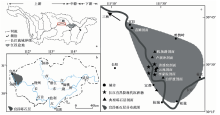
在三峡出口的宜昌以东的丘陵区分布着1套巨厚的松散状砾石层, 本文称之为宜昌砾石层。 近年来, 作者通过系统的区域地质调查, 发现该套砾石层分布在三峡东部以宜昌、 松滋、 枝江北一带为边界的丘陵和岗地, 地表分布面积逾1 000km2, 剖面测量显示最大厚度达110m(图 1)。

图 1 宜昌砾石层分布范围及其位置概略图
a 江汉盆地位于三峡的出口处; b 宜昌砾石层堆积于江汉盆地的西缘; c 宜昌砾石层的分布范围及其典型剖面
Fig. 1 Location and distribution of Yichang Gravel, Jianghan Plain.

根据地质地貌特征和多个典型剖面的沉积学特征分析, 宜昌砾石层为一大型冲积扇体(李庭等, 2010; 康春国等, 2014)。 受荆门-松滋断层影响, 在松滋至枝江一线以东该冲积扇隐伏于地下。 野外地质调查和钻孔资料表明, 宜昌砾石层不整合于白垩— 古近纪红层之上, 上覆地层为长江中下游地区广泛发育的网纹红土层。 白垩— 古近纪红层的岩性为褐红色、 棕红色粉砂岩, 水平层理发育, 属典型的湖相沉积。 据湖北区域地质志课题组的最新研究结果可知, 江汉盆地缺失新近纪沉积; 区域地质地貌分析认为, 宜昌砾石层是江汉盆地西缘白垩— 古近纪湖相红层沉积结束后最早的河流沉积, 是江汉盆地周缘规模最大的砾质冲积扇, 其与长江贯通三峡存在明显的侵蚀-沉积相关性。 前人通过地貌、 沉积相和物源示踪初步分析认为宜昌砾石层是三峡贯通的直接沉积(Xiang et al., 2007, 2018; 康春国等, 2009; 张勇等, 2009)。 因此, 宜昌砾石层的年龄可为长江贯通三峡提供重要的年代约束。 而如何准确确定宜昌砾石层的形成年代和时间跨度是现有研究中的一个重点和难点, 同时也是本文研究的突破点。 目前, 晚新生代砾石层的定年主要采用地层对比、 古生物化石或磁性地层等相对年代学研究方法。 其中, 地层对比主要是系统开展所研究剖面的上覆地层和下伏地层的调查, 建立地层序列, 通过区域地层对比分析剖面的地质时代。 古生物地层学方法主要以判断地层中古生物化石所属的地层时代为主, 但化石在砾石层中往往不易保存, 所以在野外通过寻找动物化石来判断砾石层年代具有很大的偶然性, 此外宜昌砾石层中至今还未发现有动物化石。 磁性地层学方法是将地层剖面在整个沉积过程内所记录的地磁场反转序列, 即磁性地层与标准地磁极性年表进行对比来获得地层剖面的年代框架。 由于磁性地层学测年的对象主要为细粒或极细粒沉积物, 对砾石剖面进行测年时只能对砾石层中夹杂的细粉砂做采样分析, 或采用地层追踪的方法在周边区域寻找与砾石地层相当的细粒地层开展磁性地层研究, 因此在缺乏细粒沉积夹层的剖面中难以开展基于该方法的年代学工作。 同时, 对于可能存在沉积间断或缺失的砾石地层, 磁性地层学年代结果可能难以令人信服。 综上所述, 可靠的相对年代学研究在宜昌砾石层中难以取得较好的成果。 因此, 直接对快速堆积的宜昌砾石层开展年代学研究就需要寻找一种更可靠的绝对测年方法。

近20a以来, 沉积物石英Ti-Li心ESR测年是逐渐发展并成功应用于年代为n× 106~n× 107a碎屑沉积物的绝对测年技术, 该方法现已被成熟地应用于水成沉积物的测年研究中(Toyoda et al., 2000; Beerten et al., 2006, 2007; Rink et al., 2007; Voinchet et al., 2007; Tissoux et al., 2008; 刘春茹等, 2009, 2011; Liu et al., 2010, 2011, 2013a, b, 2014, 2015; 王萍等, 2011; Duval et al., 2017; 李文朋等, 2018)。 本文对宜昌砾石层中3个连续且具代表性的沉积剖面进行了系统的样品采集, 采用石英Ti-Li心ESR测年方法对其堆积年代和地层时代跨度进行研究, 确定了宜昌砾石层堆积的绝对年代, 可为长江贯通三峡提供可靠的年代约束。

1 剖面特征及样品采集
1.1 剖面特征

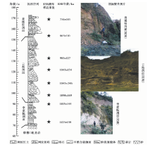
宜昌砾石层分布在三峡东部山前以宜昌、 松滋、 枝江北为顶点的丘陵和岗地上, 地表分布面积逾1 000km2, 剖面测量显示其最大厚度达110m。 其中, 位于长江右岸云池港附近的善溪窑剖面、 云池剖面和李家院剖面出露最新、 沉积序列最完整(图 2)。 3个剖面分布在长江河谷右岸谷坡的不同高度上, 且水平距离较近。 野外调查结果显示3个剖面呈上下层位关系, 基本为连续沉积, 砾石层的总厚度达110m。 其中, 善溪窑剖面和云池剖面呈连续的直接上下接触关系(李庭等, 2010)。

图 2 宜昌砾石层剖面序列、 野外照片及ESR测年样品采集点示意图Fig. 2 Sketch map showing lithological column and sampling horizon position as well as pictures of the Yichang Gravel profile.

善溪窑剖面出露于宜昌市枝江市白洋镇善溪窑村318国道旁(30° 28'53.4″N, 111° 27'38.76″E), 剖面厚约19.5m, 出露海拔为152.0~172.5m, 上覆网纹红土。

云池剖面出露于宜昌市猇亭区云池港对面318国道旁(30° 27'50.94″N, 111° 27'10.70″E), 剖面厚约60m, 出露海拔为92.0~152.0m。 其岩性组合与善溪窑剖面大致相同, 砾径比善溪窑剖面稍小, 但出露大型砂质透镜体(厚3~6m)。

李家院剖面出露于宜昌市猇亭区李家院(30° 28'22.86″N, 111° 27'11.58″E), 剖面厚约21m, 出露海拔为69~90m, 不整合在白垩纪基岩之上。 砾石的磨圆好, 砾径小, 一般为2~5cm, 且分选更好; 在其下部出露近11m的砂质沉积层(未见底)。 3个剖面组成1套完整的砾石层沉积, 上覆中更新世网纹红土, 下伏白垩纪红色砂岩层。

1.2 样品采集

以上3个剖面在不同层位均发育2~5m的厚层砂质透镜体, 是进行沉积物Ti-Li心ESR测年的理想材料。 根据剖面层序, 在3个剖面的不同层位确定了8个样品采集点, 如图 2 所示。

善溪窑剖面: 在剖面下部和上部层位取砂质样品各1个, 样品编号为SXY-1(下部)和SXY-2(上部)。

云池剖面: 从剖面底部到顶部共取砂质透镜体样品4个, 编号分别为YC-1、 YC-2、 YC-3和YC-4。

李家院剖面: 在剖面下部砂层距砂层顶部2m处取样品LJY-1; 在剖面上部距剖面顶部3m处取砂质样品LJY-2。

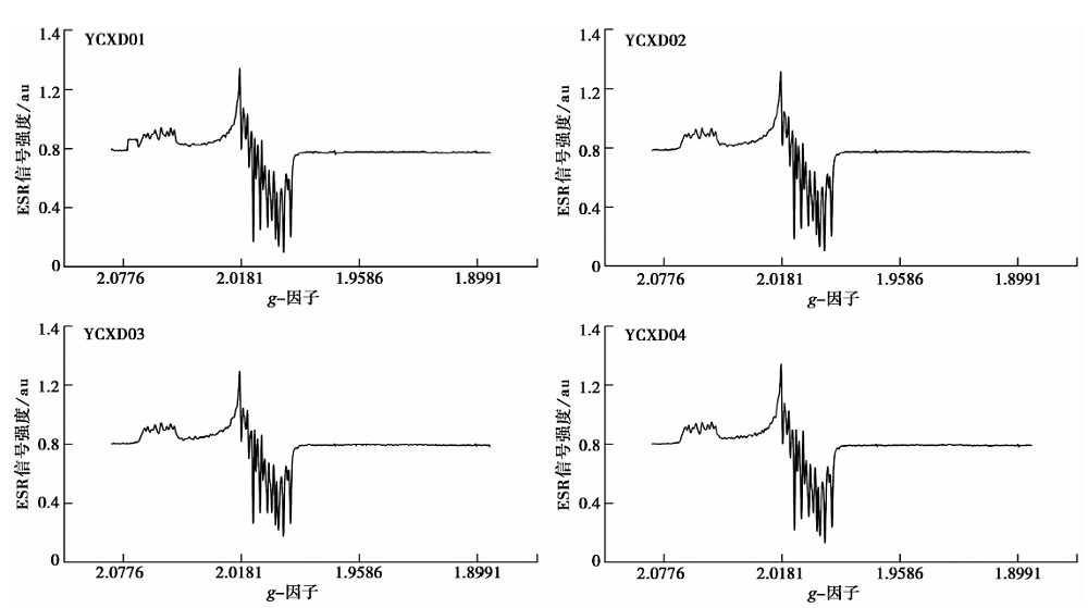
此外, 为确定宜昌砾石层沉积时砂质透镜体石英颗粒Ti-Li心的ESR信号强度本底, 在宜昌砾石层附近的长江左、 右边滩不同位置共随机采取了4个现代河流沉积物样品, 编号为YCXD01、 YCXD02、 YCXD03和YCXD04。

2 实验方法
2.1 石英提取

样品的前处理过程均在中国地震局地质研究所地震动力学国家重点实验室新构造年代学ESR实验室完成。 首先将样品低温烘干(40℃), 利用化学方法提纯石英颗粒。 Liu等(2015)研究指出100~200μ m颗粒是河流沉积物石英Ti-Li心ESR测年的最佳粒径组分。 因此, 用湿筛法筛选粒径125~175μ m的样品颗粒; 用30%的H2O2溶液浸泡样品直至完全去除有机质; 用蒸馏水洗至中性后用40%的HCL溶液浸泡样品直至完全去除碳酸盐类物质; 再用蒸馏水洗至中性后用40%的HF溶液浸泡40min以去除长石矿物和石英颗粒外部α 辐射贡献的表层部分; 用蒸馏水洗至中性后再用40%的HCL溶液浸泡样品24h以去除氟化物; 用蒸馏水洗至中性后低温烘干样品, 用磁选仪去除磁性矿物。 然后, 用多钨酸钠进行重液分离, 分选出石英颗粒样品, 并进行低温烘干。 将提纯后的石英样品送往中国地质大学(武汉)地质过程与矿产资源国家重点实验室X射线衍射仪实验室进行物相分析。 结果显示, 提纯后8个样品的石英含量为97.19%~99.99%。

2.2 钴源辐照

将提纯后的每个石英样品等分成13份, 每份0.18g, 送往北京大学化学学院应用化学系钴源实验室分别接受60Co γ 射线100Gy、 200Gy、 400Gy、 800Gy、 1 200Gy、 1 600Gy、 2 000Gy、 2 500Gy、 3 000Gy、 5 000Gy、 6 000Gy、 7 000Gy和9 000Gy剂量的辐照, 辐照后静置2个月, 去除辐照后的不稳定信号, 再进行ESR信号测量。

2.3 环境剂量率

环境剂量率可通过测量样品中的U、 Th、 K含量和含水量获得(Aitken, 1998)。 其中, 因野外采样时的含水量不能代表样品沉积历史时期的真实含水量, 故本研究中样品的含水量统一取估算值, 为(8± 5)%。 本研究中样品的U、 Th、 K元素含量测定在北京核工业地质研究院质谱实验室用ICP-MS方法测量完成, 仪器为Finnigan MAT制造的HR-ICP-MS仪。 因本研究中样品采集的层位埋深均大于2m, 故宇宙射线对环境剂量率的贡献可忽略不计。

2.4 ESR信号强度测量

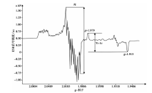
石英ESR信号强度测量工作在中国地震局地质研究所地震动力学国家重点实验室新构造年代学ESR实验室完成, 采用德国BRUKER EPR041XG微波桥X波段谱仪进行测量。 测试条件为: 低温(液氮, 77K), 微波功率为5mW, 微波频率为9.46GHz, 调制频率为100kHz, 调制幅度为0.16mT, 中心磁场为3 400G, 接受增益为8.93× 10³, 扫描时长为42s, Q值为200且稳定不变(刘春茹等, 2016; 李文朋等, 2018)。 石英Ti-Li心ESR信号的测量位置为g=1.979的峰顶至g=1.913的峰底(Rink et al., 2007), 见图 3。 在相同条件下对所有样品均测量6个方向的信号, 取其平均值作为该样品的ESR信号强度。

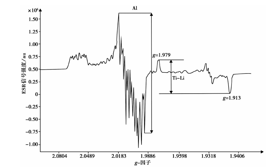
图 3 石英样品低温(液氮, 77K)测试条件下的Al心和Ti-Li心的ESR信号谱图Fig. 3 ESR spectrum showing quartz Al center and Ti-Li center of natural sample observed at low temperature(liquid nitrogen, 77K).

3 结果与讨论
3.1 现代河流沉积物的石英Ti-Li心ESR信号强度

ESR法年龄的测定主要涉及2部分, 即环境剂量率(Dose rate(D), 单位为Gy/ka)和等效剂量(Equivalent Dose(De), 单位为Gy)的求取。 只有ESR信号在重新积累前完全归零, 所观测到的ESR信号才等于其真实的信号强度; 否则, 观测到的ESR信号是其真实累积的信号值与残留值的总和, 继而得到的ESR年龄结果比真实年龄偏老(刘春茹等, 2016)。 因此, 确定被测样品沉积前其ESR信号是否回零或其残留值的大小, 对获得准确可靠的ESR埋藏年龄具有重要意义(魏传义等, 2018)。

目前, 对大河流域河流沉积物的石英Ti-Li心ESR信号强度的本底(即现代河流沉积物的石英Ti-Li心ESR信号残留值)进行求取, 主要通过采集并计算其附近地区现代河流沉积物的ESR信号强度, 并以此作为本底或参考标本(Beerten et al., 2006, 2007; Rink et al., 2007; Voinchet et al., 2007; Tissoux et al., 2008; 刘春茹等, 2009, 2011; Liu et al., 2010, 2011, 2013a, b, 2014, 2015; 王萍等, 2011; Duval et al., 2017)。 对所采集的长江宜昌段4个现代河流边滩沉积物样品的石英Ti-Li心ESR信号强度进行了测量, 结果见图 4。 谱图显示, 4个现代河流边滩沉积物样品的石英Ti-Li心测量峰位与其基线持平, 无法测量其ESR信号强度, 表明在搬运过程中所产生的机械碰撞作用和接受的光照作用足以使4个样品的石英Ti-Li心ESR信号强度在埋藏之前就已达到回零状态。 因此, 我们认为宜昌砾石层砂质透镜体中石英的Ti-Li心ESR信号强度在埋藏之前其也已达到回零状态, 无任何信号残留, 后期实验测量获得的等效剂量就是其自埋藏以来获得的真实等效剂量。 由此可知, 本文利用石英Ti-Li心ESR信号对宜昌砾石层砂质透镜体进行年代测定得到的年龄结果是可靠的。

图 4 长江宜昌段现代河流沉积物石英Al心和Ti-Li心的ESR信号强度谱图Fig. 4 ESR spectrum showing quartz Al center and Ti-Li center of modern fluvial sediment in Yichang area of Yangtze River.

3.2 等效剂量及年龄测定

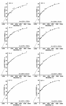
样品等效剂量的测定是根据实验测量获得的石英Ti-Li心ESR信号强度, 采用非线性公式Y=S× {1-exp[-L(X+P)]}进行指数拟合而得到的, 如图 5 和表1所示。 其中, Y为ESR信号强度, S为样品ESR信号的饱和剂量, X为辐照剂量, P为等效剂量, L为拟合参数(Liu et al., 2015)。

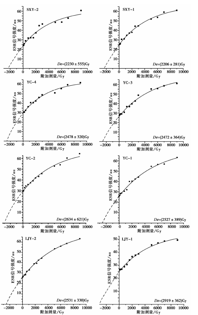
图 5 宜昌砾石层样品的石英Ti-Li心附加剂量响应曲线Fig. 5 Additional dose response curves of quartz Ti-Li center for the samples collected from Yichang Gravel, Jianghan Plain.

表1 宜昌砾石层各样品环境剂量率、 等效剂量及年龄 Table1 ESR dating result of quartz Ti-Li center in Yichang Gravel, Jianghan Plain

由图 5 和表1可知, 宜昌砾石层剖面样品的ESR年龄随深度的增加而增大, 且没有年龄倒置现象。 石英Ti-Li心的ESR测年结果显示, 宜昌砾石层的年代范围大致为0.7~1.1Ma BP, 时间跨度为0.4Ma。

3.3 对长江贯通三峡年代的指示意义

自2007年以来, 多位学者运用重矿物组合特征(向芳, 2004; 向芳等, 2006a, b; Xiang et al., 2007; 康春国等, 2014)、 磁学特征(张勇等, 2009; 张玉芬等, 2014)、 U-Pb锆石年龄谱(向芳等, 2011)、 孢粉组合特征(Wang et al., 2014)和钾长石Pb同位素特征(张增杰, 2016)等方法对宜昌砾石层的物质来源进行了示踪研究。 前人的研究结果表明青藏高原东缘地带及四川盆地是宜昌砾石层堆积物质的主要源区, 且这些沉积物由1条类似于现代长江的大型水系搬运而来, 因此推断宜昌冲积扇是由长江上游切穿三峡堆积而成。 本文的结果显示, 宜昌砾石层堆积的时间下限为1.12Ma BP, 结合物源示踪结果分析认为至少在1.12Ma BP长江三峡已被切穿, 使上游与中下游连在一起形成现代意义上的长江。

4 结论

(1)对长江宜昌段现代表层河流沉积物的石英Ti-Li心ESR信号强度进行测量检验, 发现宜昌砾石层厚层砂质透镜体沉积物在埋藏之前, 其石英Ti-Li心ESR信号可完全达到回零状态; 此外, 宜昌砾石层的样品年龄随深度的增加而变大, 没有出现倒置现象, 也说明了砂质透镜体中石英Ti-Li心ESR信号在埋藏之前得到了完全晒退, 无任何残留。 综上所述, 本文得到的年龄结果是可靠的。

(2)利用石英Ti-Li心ESR法对宜昌砾石层3个连续典型剖面中8个厚层砂质透镜体进行了独立年代测定, 所得结果表明, 宜昌砾石层的堆积年代约0.73~1.12Ma BP, 从底到顶堆积的时间跨度约0.4Ma。

(3)结合前人的物源示踪结果, 本文得到的宜昌砾石层的年龄结果说明长江贯通三峡的时间下限是1.12Ma BP, 即至少在早更新世晚期长江就已经贯通三峡。

(4)石英Ti-Li心ESR测年法在宜昌砾石层厚层砂质透镜体中的成功应用表明该方法在砾石层测年研究中具有较好的应用前景。

致谢 北京大学钴源实验室李久强教授在本次研究样品辐照过程中给予了帮助, 在此表示衷心感谢!

参考文献
[1] 康春国, 李长安, 王节涛, . 2009. 江汉平原沉积物重矿物特征及其对三峡贯通的指示[J]. 地球科学(中国地质大学学报), 34(3): 419427. doi: DOI: 103321/j. issn: 1000-2383. 2009. 03. 006.
KANG Chun-guo, LI Chang-an, WANG Jie-tao, et al. 2009. Heavy mineral characteristics of sediments in Jianghan Plain and its indication to the Three Gorges[J]. Earth Science(Journal of China University of Geosciences), 34(3): 419427(in Chinese). [本文引用:1]
[2] 康春国, 李长安, 张玉芬, . 2014. 宜昌砾石层重矿物组合特征及物源示踪分析[J]. 地质学报, 88(2): 254262. doi: DOI: 103969/j. issn. 0001-5717. 2014. 02. 008.
KANG Chun-guo, LI Chang-an, ZHANG Yu-fen, et al. 2014. Heavy mineral characteristics of the Yichang gravel layers and provenance tracing[J]. Acta Geologica Sinica, 88(2): 254262(in Chinese). [本文引用:2]
[3] 李长安, 张玉芬. 1999. 一次重要的第四纪构造运动及环境效应[J]. 地质科技情报, 18(4): 4246. doi: DOI: 103969/j. issn. 1000-7849. 1999. 04. 009.
LI Chang-an, ZHANG Yu-fen. 1999. An important tectonic movement and its environmental effect in Quaternary[J]. Geological Science and Technology Information, 18(4): 4246(in Chinese). [本文引用:1]
[4] 李庭, 李长安, 康春国, . 2010. 宜昌砾石层的沉积环境及地貌意义[J]. 中国地质, 37(2): 438445. doi: DOI: 103969/j. issn. 1000-3657. 201002. 017.
LI Ting, LI Chang-an, KANG Chun-guo, et al. 2010. Sedimentary environment and geomorphological significance of the gravel bed in Yichang[J]. Geology in China, 37(2): 438445(in Chinese). [本文引用:2]
[5] 李文朋, 刘春茹, 牛东伟, . 2018. 怀来盆地珠窝堡遗址ESR年代学初步研究[J]. 第四纪研究, 38(3): 680687. doi: DOI: 1011928/j. issn. 1001-74102018. 03. 12.
LI Wen-peng, LIU Chun-ru, NIU Dong-wei, et al. 2018. Electron spin resonance data of the Zhuwobao paleolithic site in the Huailai Basin of China[J]. Quaternary Sciences, 38(3): 680687(in Chinese). [本文引用:2]
[6] 刘春茹, 尹功明, 高璐, . 2009. 泥河湾盆地东坡遗址ESR年代学初步研究[J]. 第四纪研究, 29(1): 166172.
LIU Chun-ru, YIN Gong-ming, GAO Lu, et al. 2009. ESR dating of Dongpo paleolithic site in the Nihewan Basin of China[J]. Quaternary Sciences, 29(1): 166172(in Chinese). [本文引用:2]
[7] 刘春茹, 尹功明, 高璐, . 2011. 第四纪沉积物 ESR 年代学研究进展[J]. 地震地质, 33(2): 490498. doi: DOI: 103969/j. issn. 0253-4967. 2011. 02. 022.
LIU Chun-ru, YIN Gong-ming, GAO Lu, et al. 2011. Research advances in ESR geochronology of Quaternary deposits[J]. Seismology and Geology, 33(2): 490498(in Chinese). [本文引用:2]
[8] 刘春茹, 尹功明, 韩非, . 2016. 石英ESR测年法在第四纪陆相沉积物测年中的应用[J]. 第四纪研究, 36(5): 12361245. doi: DOI: 1011928/j. issn. 1001-74102016. 05. 18.
LIU Chun-ru, YIN Gong-ming, HAN Fei, et al. 2016. ESR dating methodology and its application in dating Quaternary terrestrial sediments[J]. Quaternary Sciences, 36(5): 12361245(in Chinese). [本文引用:2]
[9] 王萍, 李建平, 王建存, . 2011. 四川昔格达组地层的石英Ti心ESR测年及与磁性地层剖面的对比[J]. 核技术, 34(2): 111115.
WANG Ping, LI Jian-ping, WANG Jian-cun, et al. 2011. Quartz Ti-center in ESR dating of Xigeda formation in Sichuan and contrast with magnetic stratigraphic profiles[J]. Nuclear Techniques, 34(2): 111115(in Chinese). [本文引用:2]
[10] 魏传义, 刘春茹, 李长安, . 2018. 石英不同Ti-Li心电子自旋共振信号光晒退特征及其测年意义[J]. 地球环境学报, 9(6): 607613. doi: DOI: 107515/JEE182053.
WEI Chuan-yi, LIU Chun-ru, LI Chang-an, et al. 2018. Bleaching characteristics of quartz electron spin resonance(ESR)signals of multiple Ti-Li centers: Implication for ESR dating[J]. Journal of Earth Environment, 9(6): 607613(in Chinese). [本文引用:1]
[11] 向芳. 2004. 长江三峡的贯通与江汉盆地西缘及邻区的沉积响应 [D]. 成都: 成都理工大学.
XIANG Fang. 2004. Forming of the Three Gorges of the Yangtze River and sedimentary response in the west edge of Jianghan Basin and adjacent area [D]. Chengdu University of Technology, Chengdu(in Chinese). [本文引用:1]
[12] 向芳, 王成善, 李国忠, . 2006a. 宜昌地区第四纪沉积物重矿物特征及其与三峡贯通的关系[J]. 成都理工大学学报(自然科学版), 33(2): 117121. doi: DOI: 103969/j. issn. 1671-9727. 2006. 02. 002.
XIANG Fang, WANG Cheng-shan, LI Guo-zhong, et al. 2006a. Character of heavy minerals in Quaternary sediments in Yichang area and its relationship with cut-through of the Yangtze Three Gorges, China[J]. Journal of Chengdu University of Technology(Science and Technology Edition), 33(2): 117121(in Chinese). [本文引用:1]
[13] 向芳, 杨栋, 田馨, . 2011. 湖北宜昌地区第四纪沉积物中锆石的U-Pb年龄特征及其物源意义[J]. 矿物岩石, 31(2): 106114. doi: DOI: 103969/j. issn. 1001-6872. 2011. 02. 015.
XIANG Fang, YANG Dong, TIAN Xin, et al. 2011. LA-ICP-MS U-Pb geochronology of zircons in the Quaternary sediments from the Yichang area of Hubei Province and its provenance significance[J]. Journal of Mineral Petrol, 31(2): 106114(in Chinese). [本文引用:1]
[14] 向芳, 朱利东, 王成善, . 2006b. 宜昌地区第四纪沉积物中玄武岩砾石特征及其与长江三峡贯通的关系[J]. 地球科学与环境学报, 28(2): 610. doi: DOI: 103969/j. issn. 1672-6561. 2006. 02. 002.
XIANG Fang, ZHU Li-dong, WANG Cheng-shan, et al. 2006b. Character of basaltic gravels in Quaternary sediments in Yichang area and its relationship with formation of Yangtze Three Gorges[J]. Journal of Earth and Environment, 28(2): 610(in Chinese). [本文引用:1]
[15] 张勇, 张玉芬, 李长安, . 2009. 宜昌地区砾石层的磁性特征与物源分析[J]. 第四纪研究, 29(2): 380386. doi: DOI: 101-7410(2009)-380-07.
ZHANG Yong, ZHANG Yu-fen, LI Chang-an, et al. 2009. Magnetic properties of the gravel layers in Yichang area and their provenance[J]. Quaternary Sciences, 29(2): 380386(in Chinese). [本文引用:2]
[16] 张玉芬, 李长安, 周稠, . 2014. 长江中游高位砾石层的磁性特征与物源分析[J]. 吉林大学学报(地球科学版), 44(5): 16691677. doi: DOI: 1013278/j. cnki. jjuese. 201405301.
ZHANG Yu-fen, LI Chang-an, ZHOU Chou, et al. 2014. Magnetism and provenance analysis of high position gravel layer in the middle reaches of Yangtze River[J]. Journal of Jilin University(Earth Science Edition), 44(5): 16691677(in Chinese). [本文引用:1]
[17] 张增杰. 2016. 长江水系晚新生代沉积物碎屑钾长石Pb同位素组成 [D]. 武汉: 中国地质大学.
ZHANG Zeng-jie. 2016. Pb isotopic compositions of detrital K-feldspar grains of the late Cenozoic sediments from the Yangtze River system [D]. China University of Geosciences, Wuhan(in Chinese). [本文引用:1]
[18] 赵诚. 1996. 长江三峡河流袭夺与河流起源[J]. 长春地质学院学报, 26(4): 428433.
ZHAO Cheng. 1996. River capture and origin of the Yangtze Gorges[J]. Journal of Changchun University of Earth Sciences, 26(4): 428433(in Chinese). [本文引用:1]
[19] 赵诚, 王世梅. 2000. 长江三峡及其上游河流袭夺新认识[J]. 武汉水利电力大学(宜昌)学报, 22(3): 196199. doi: DOI: 103969/j. issn. 1672-948X. 2000. 03. 003.
ZHAO Cheng, WANG Shi-mei. 2000. New recognition of river capture in Three Gorges and its upper reaches[J]. Journal of University of Hydraulic and Electric Engineering(Yichang), 22(3): 196199(in Chinese). [本文引用:1]
[20] Aitken M J. 1998. An Introduction to Optical Dating [M]. London, Oxford University Press: 3944. [本文引用:1]
[21] Beerten K, Stesmans A. 2006. The use of Ti centers for estimating burial doses of single quartz grains: A case study from an aeolian deposit~2Ma old[J]. Radiation Measurements, 41(4): 418424. doi: DOI:10.1016/j.radmeas.2005.10.004. [本文引用:2]
[22] Beerten K, Stesmans A. 2007. ESR dating of sedimentary quartz: Possibilities and limitations of the single-grain approach[J]. Quaternary Geochronology, 2(1): 373380. doi: DOI:10.1016/j.quageo.2006.03.003. [本文引用:2]
[23] Bridgland D R, Westaway R. 2014. Quaternary fluvial archives and land scape evolution: A global synthesis[J]. Proceedings of the Geologists Association, 125(5-6): 600629. doi: DOI:10.1016/j.pgeola.2014.10.009. [本文引用:1]
[24] Clark M K, Schoenbohm L M, Royden L H, et al. 2004. Surface uplift, tectonics, and erosion of eastern Tibet from large-scale drainage patterns[J]. Tectonics, 23(1): TC1006. doi: DOI:10.1029/2002tc001402. [本文引用:1]
[25] Clift P D, Carter A, Campbell I H, et al. 2013. Thermochronology of mineral grains in the Red and Mekong Rivers, Vietnam: Provenance and exhumation implications for Southeast Asia[J]. Geochemistry Geophysics Geosystems, 7(10): 123129. doi: DOI:10.1029/2006gc001336. [本文引用:1]
[26] Duval M, Arnold L J, Guilarte V, et al. 2017. Electron spin resonance dating of optically bleached quartz grains from the Middle Palaeolithic site of Cuesta de la Bajada(Spain)using the multiple centres approach[J]. Quaternary Geochronology, 37: 8296. doi: DOI:10.1016/j.quageo.2016.09.006. [本文引用:2]
[27] Gu J, Chen J, Sun Q, et al. 2014. China’s Yangtze delta: Geochemical fingerprints reflecting river connection to the sea[J]. Geomorphology, 227: 166173. doi: DOI:10.1016/j.geomorph.2014.05.015. [本文引用:1]
[28] Liu C R, Grün R. 2011. Fluvio-mechanical resetting of the Al and Ti centres in quartz[J]. Radiation Measurements, 46(10): 10381042. doi: DOI:10.1016/j.radmeas.2011.06.076. [本文引用:2]
[29] Liu C R, Yin G M, Deng C L, et al. 2014. ESR dating of the Majuangou and Banshan Paleolithic sites in the Nihewan Basin, North China[J]. Journal of Human Evolution, 73(4): 5863. doi: DOI:10.1016/j.jhevol.2014.05.012. [本文引用:2]
[30] Liu C R, Yin G M, Gao L, et al. 2010. ESR dating of Pleistocene archaeological localities of the Nihewan Basin, North China: Preliminary results[J]. Quaternary Geochronology, 5(2): 385390. doi: DOI:10.1016/j.quageo.2009.05.006. [本文引用:2]
[31] Liu C R, Yin G M, Gao L, et al. 2013a. ESR dating of the Donggutuo Palaeolithic site in the Nihewan Basin, northern China[J]. Geochronometria, 40(4): 348354. doi: DOI:10.2478/s13386-013-0127-4. [本文引用:2]
[32] Liu C R, Yin G M, Han F. 2015. Effects of grain size on quartz ESR dating of Ti-Li center in fluvial and lacustrine sediments[J]. Quaternary Geochronology, 30(2): 513518. doi: DOI:10.1016/j.quageo.2015.02.007. [本文引用:4]
[33] Liu C R, Yin G M, Zhang H P, et al. 2013b. ESR geochronology of the Minjiang River terraces at Wenchuan, eastern margin of Tibetan plateau, China[J]. Geochronometria, 40(4): 360367. doi: DOI:10.2478/s13386-013-0129-2. [本文引用:2]
[34] Parton A, Farrant A R, Leng M J, et al. 2015. Alluvial fan records from southeast Arabia reveal multiple windows for human dispersal[J]. Geology, 43(4): 295298. doi: DOI:10.1130/G36401.1. [本文引用:1]
[35] Richardson N J, Densmore A L, Seward D, et al. 2010. Did incision of the Three Gorges begin in the Eocene?REPLY[J]. Geology, 38(6): 551554. doi: DOI:10.1130/G30527.1. [本文引用:1]
[36] Rink W J, Bartoll J, Schwarcz H P, et al. 2007. Testing the reliability of ESR dating of optically exposed buried quartz sediments[J]. Radiation Measurements, 42(10): 16181626. doi: DOI:10.1016/j.radmeas.2007.09.005. [本文引用:3]
[37] Tissoux H, Toyoda S, Falguères C, et al. 2008. ESR dating of sedimentary quartz from two Pleistocene deposits using Al and Ti-centers[J]. Geochronometria, 30(1): 2331. doi: DOI:10.2478/v10003-008-0004-y. [本文引用:2]
[38] Toyoda S, Hattori W. 2000. Formation and decay of the E’center and of its precursor[J]. Applied Radiation and Isotopes, 52(5): 13511356. doi: DOI:10.1016/S0969-8043(00)00094-4. [本文引用:1]
[39] Voinchet P, Falguères C, Tissoux H, et al. 2007. ESR dating of fluvial quartz: Estimate of the minimal distance transport required for getting a maximum optical bleaching[J]. Quaternary Geochronology, 2(1): 363366. doi: DOI:10.1016/j.quageo.2006.04.010. [本文引用:2]
[40] Wang P, Zheng H B, Chen L, et al. 2014. Exhumation of the Huangling anticline in the Three Gorges region: Cenozoic sedimentary record from the western Jianghan Basin, China[J]. Basin Research, 26(4): 505522. doi: DOI:10.1111/bre.12047. [本文引用:2]
[41] Xiang F, Du W, Huang H, et al. 2018. Provenance study of Fe-Ti oxide minerals in the Quaternary sediments in Yichang area and its implication of formation time of the Yangtze Three Gorges, China[J]. Acta Geologica Sinica(English Edition), 92(4): 15981608. [本文引用:1]
[42] Xiang F, Zhu L D, Wang C S, et al. 2007. Quaternary sediment in the Yichang area: Implications for the formation of the Three Gorges of the Yangtze River[J]. Geomorphology, 85(3): 249258. doi: DOI:10.1016/j.geomorph.2006.03.027. [本文引用:3]
[43] Yang S, Li C, Yokoyama K. 2006. Elemental compositions and monazite age patterns of core sediments in the Changjiang Delta: Implications for sediment provenance and development history of the Changjiang River[J]. Earth and Planetary Science Letters, 245(3-4): 762776. doi: DOI:10.1016/j.epsl.2006.03.042. [本文引用:1]
[44] Zheng H B, Clift P D, Wang P, et al. 2013. Pre-Miocene birth of the Yangtze River[J]. Proceedings of the National Academy of Sciences of the United States of America, 110(19): 75567561. doi: DOI:10.1073/pnas.1216241110. [本文引用:1]