

青藏高原东北部龙首山晚新生代剥露历史:来自磷灰石(U-Th)/He的证据
[李佳昱1, 2)  , 郑文俊
, 郑文俊1, 2), * , 王伟涛1, 2) , 王英3) , 张培震1, 2) , 王洋1, 2) ]
, 郑文俊, 王伟涛|
|


〔作者简介〕 李佳昱, 女, 1994年生, 2017年于长安大学地球科学与资源学院获地质学学士学位, 主要从事新构造、 低温热年代学方面的研究, E-mail: lijy285@mail2.sysu.edu.cn。
龙首山位于阿拉善地块南缘, 也是青藏高原东北部最外围的山脉之一。 揭示龙首山新生代构造变形与隆升过程对于理解青藏高原东北部的隆升与向外扩展及其动力学机制具有重要意义。 文中利用磷灰石(U-Th)/He方法, 对青藏高原东北部龙首山南、 北两侧岩石的侵蚀与隆升过程开展研究。 采集自龙首山南缘的11个磷灰石的(U-Th)/He年龄结果显示, 在其南缘断层的控制下, 龙首山约于14Ma BP发生了强烈隆升或剥蚀, 导致上部岩石快速冷却。 而在龙首山北缘采集的3个样品的年龄较老(220~240Ma), 但年龄非常相近, 表明其北侧活动较弱, 龙首山整体表现为掀斜模式。 龙首山中中新世由南向北的掀斜式抬升不仅揭示了青藏高原东北部挤压应变可能由南向北扩展, 同时也限定了青藏高原在中中新世已向NE扩展至阿拉善地块南缘, 使龙首山成为高原东北部现今构造与地貌的边界。
Longshou Shan, located at the southern edge of the Alxa block, is one of the outermost peripheral mountains and the northeasternmost area of the northeastern Tibetan plateau. In recent years, through geochronology, thermochronology, magnetic stratigraphy and other methods, a large number of studies have been carried out on the initiation time of major faults, the exhumation history of mountains and the formation and evolution of basins in the northeastern Tibet Plateau, the question of whether and when the northeastward expansion of the northeastern Tibet Plateau has affected the southern part of the Alxa block has been raised. Therefore, the exhumation history of Longshou Shan provides significant insight on the uplift and expansion of the Tibetan plateau and their dynamic mechanism. The Longshou Shan, trending NWW, is the largest mountain range in the Hexi Corridor Basin, and its highest peak is more than 3 600m(with average elevation of 2800m), where the average elevation of Hexi Corridor is 1 600m, the relative height difference between them is nearly 2200m. This mountain is bounded by two parallel thrust faults: The North Longshou Shan Fault(NLSF)and the South Longshou Shan Fault(SLSF), both of them trends NWW and has high angle of inclination(45°~70°)but dips opposite to each other. The South Longshou Shan Fault, located in the northern margin of the Hexi Corridor Basin, is the most active fault on the northeastern plateau, and controls the uplift of Longshou Shan.Due to its lower closure temperature, the lower-temperature thermochronology method can more accurately constrain the cooling process of a geological body in the upper crust. In recent years, the low-temperature thermochronology method has been used more and more in the study of the erosion of orogenic belts, the evolution of sedimentary basins and tectonic geomorphology. In this study, the apatite (U-Th)/He(AHe) method is used to analyze the erosion and uplift of rocks on the south and north sides of Longshou Shan. 11 AHe samples collected from the south slope exhibit variable AHe ages between~8Ma and~200Ma, the age-elevation plot shows that before 13~17Ma, the erosion rate of the Longshou Shan is very low, and then rapid erosion occurs in the mountain range, which indicates that the strong uplift of Longshou Shan occurred at 13~17Ma BP, resulting in rapid cooling of the southern rocks. In contrast, 3 AHe ages obtained from the north slope are older and more concentrated ranging from 220Ma BP to 240Ma BP, indicating that the north slope can be seen as a paleo-isothermal surface and the activity of the north side is weak. The results of thermal history inverse modeling show that the South Longshou Shan Fault was in a tectonic quiet period until the cooling rate suddenly increased to 3.33℃/Ma at 14Ma BP, indicating that Longshou Shan had not experienced large tectonic events before~14Ma BP.
We believe that under the control of South Longshou Shan Fault, the mountain is characterized by a northward tilting uplift at Mid-Miocene. Our results on the initial deformation of the Longshou Shan, in combination with many published studies across the northeastern margin of the Tibetan plateau, suggest that the compression strain of the northeastern margin of the Tibetan plateau may expand from south to north, and the Tibetan plateau has expanded northeastward to the southern margin of the Alxa block as early as Mid-Miocene, making Longshou Shan the current structural and geomorphic boundary of the northeastern plateau.
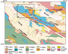
青藏高原东北部祁连山— 河西走廊盆地— 龙首山地区是高原NE向扩展的前缘地带(Hetzel et al., 2004; Zheng et al., 2010; Yuan et al., 2013; Zheng et al., 2013a; Wang et al., 2016a)。 新生代以来, 该地区受到一系列NWW走向的逆冲断裂控制, 形成了NWW走向的山脉以及与山脉近平行的压陷型沉积盆地, 构成了青藏高原东北部独特的盆-山构造体系(Mé tivier et al., 1998; Meyer et al., 1998; Zheng et al., 2010, 2017; Wang et al., 2016a)(图 1)。 这种盆-山构造体系的形成、
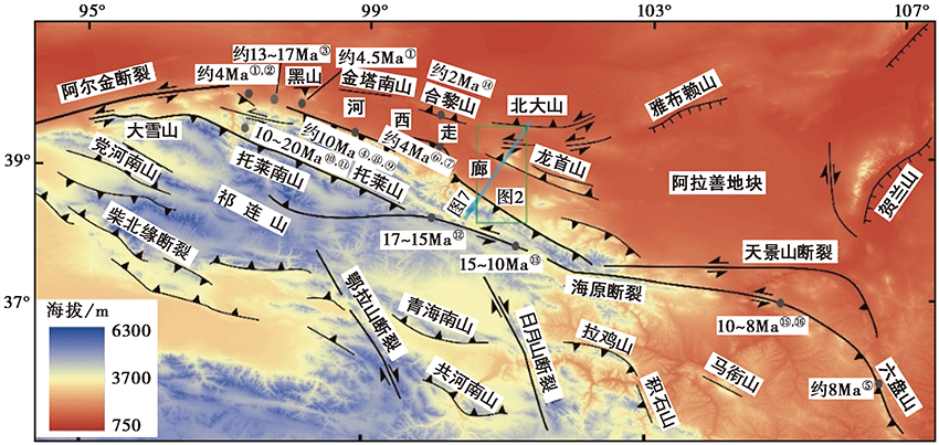 | 图 1 青藏高原东北部主要断裂和地貌格局(修改自Yu等(2017), Pang等(2019b)) 绿色线框为图2的范围; 浅蓝色实线为图 7 的剖面位置; 图中山脉隆升或断裂活动时间的年龄数据来源文献为: ① Song et al., 2001; ② Zheng et al., 2017; ③ Wang et al., 2016a; ④ Zheng et al., 2010; ⑤ Zheng et al., 2006; ⑥ Palumbo et al., 2009; ⑦ Wang Y Z et al., 2018; ⑧ Zhuang et al., 2018; ⑨ Pang et al., 2019a; ⑩ Bovet et al., 2009; ⑪ George et al., 2001; ⑪ Li et al., 2019; ⑬ Yu et al., 2019; ⑭ Zheng et al., 2013b; ⑮ Zhang et al., 2015; ⑯ Wang et al., 2014Fig. 1 Main fault and tectonic geomorphology of the northeastern Tibetan plateau(modified after Yu et al., 2017 and Pang et al., 2019b). |
发展与演化是研究青藏高原东北部构造变形的核心科学问题, 也是国际地球科学关注的热点问题之一。 在盆-山构造体系中, 山脉的抬升和变形增强了侵蚀或风化作用, 使得山脉中侵蚀下来的产物被堆积在邻近的沉积盆地。 因此, 山脉及其相邻的盆地共同记录了高原的隆升与扩展信息。
近30a以来, 众多学者针对青藏高原东北部的山脉与盆地开展了大量研究(Meyer et al., 1998; George et al., 2001; Jolivet et al., 2001; Zheng et al., 2006, 2010, 2017; Clark et al., 2010; Duvall et al., 2011; Lease et al., 2011; Yuan et al., 2013), 然而关于高原东北部新生代快速变形与隆升的时间及其扩展方式仍然存在争议(Meyer et al., 1998; Yuan et al., 2013; Zheng et al., 2017; Zhuang et al., 2018)。 一种观点认为高原东北部新生代的构造变形与阿尔金断裂的活动紧密相关, 高原东北部NWW走向的山体吸收了阿尔金断裂带的左旋走滑分量, 导致构造变形由SW向NE逐渐扩展(Mé tivier et al., 1998; Meyer et al., 1998; Yuan et al., 2013; Zheng et al., 2013a)。 另一种观点则认为青藏高原东北部在中中新世以来经历了强烈的挤压变形, 导致上地壳快速缩短, 阿尔金断裂带的左旋走滑运动仅仅调节了青藏高原东北部与塔里木盆地之间地壳差异性缩短(Zhang et al., 2007; Wang et al., 2016a; Zheng et al., 2017; Zhuang et al., 2018)。
青藏高原东北部祁连山— 龙首山新生代以来的构造变形时-空演化模式是检验上述2种变形模型的关键。 以往关于青藏高原东北部的构造变形研究主要集中在祁连山地区和河西走廊(George et al., 2001; Zheng et al., 2010; Pan et al., 2013; Wang et al., 2016a; Zhuang et al., 2018; Pang et al., 2019a), 研究结果反映了祁连山自中中新世发生了显著的构造抬升, 与此相关的变形不断向NE扩展, 已经影响到河西走廊盆地内部, 甚至越过河西走廊, 使河西走廊盆地有发展成为背驮式盆地的趋势(Meyer et al., 1998; 李奋其等, 2002; Zheng et al., 2013b; Zheng et al., 2017)。 龙首山位于阿拉善地块南缘、 河西走廊盆地北部, 是青藏高原东北部与阿拉善地块之间的构造与地貌边界, 对其开展研究对于确定高原东北部断裂-褶皱带何时变形、 变形是否已经扩展至阿拉善地块南缘具有重大意义。 然而, 目前针对龙首山构造隆升的相关研究较少, 缺乏准确的年代学约束。
本文利用磷灰石(U-Th)/He方法(封闭温度40~90℃), 从龙首山南、 北两侧共采集了14个样品, 试图以此约束龙首山的隆升历史, 进而探讨龙首山构造隆升、 变形的过程及其在青藏高原东北部构造扩展过程中的作用和意义。
祁连山— 龙首山造山带是青藏高原东北部新生代构造变形最为强烈的地区之一。 祁连山— 龙首山形成于加里东造山期(甘肃省地质矿产局, 1989), 是柴达木微地块与阿拉善微地块在早古生代中期碰撞形成的造山带, 其内部发育多条NWW走向的断裂带, 如龙首山南缘断裂带、 北祁连山北缘断裂带等(图 1)。 新生代以来, 由于受到欧亚板块与印度板块持续的会聚作用, 祁连山— 龙首山地区NWW走向的断裂带被活化, 造成祁连山— 龙首山的快速隆升, 代表了青藏高原向NE扩展的最前缘(Bovet et al., 2009; Zheng et al., 2013a, b; Wang et al., 2016a, b; Yu et al., 2017)。
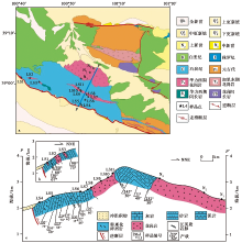
龙首山位于阿拉善地块南缘, 其南邻河西走廊盆地, 北接潮水盆地, 主要发育元古界中高级变质岩, 古生代弱变质的海相碎屑岩(多为变质泥岩和变质砂岩)、 碳酸盐岩, 中生代的变质砂岩和变质灰岩也有出露, 山体内部的岩体主要是晚古生代花岗岩(甘肃省地质矿产局, 1989)(图 2)。 前人的研究结果和资料显示, 晚白垩纪时, 由于燕山运动的影响, 该区域经历了一期隆升剥蚀过程; 新生代以来, 由于受印度和欧亚板块挤压碰撞的远程效应影响, 龙首山内部的构造重新开始活动(甘肃省地质矿产局, 1989)。 构造上, 龙首山被南、 北两侧2条近平行的反向逆冲断裂所围限(国家地震局地质研究所等, 1993; 郑文俊等, 2013; Yu et al., 2017)(图 2), 地球物理探测资料以及野外地质调查显示, 龙首山南缘断裂往S向河西走廊内部逆冲(国家地震局地质研究所等, 1993; 张进等, 2007; 金胜等, 2012; Zhang et al., 2017), 并与北祁连山形成对冲样式(国家地震局地质研究所等, 1993; 李奋其等, 2002), 而龙首山北缘断裂被认为是1954年山丹M7¼ 地震的发震断裂(郑文俊等, 2013)。 张进等(2007)根据不同时代地层被错断的痕迹推测龙首山至少在中新世有过活动, 而其它一些研究报道的龙首山的活动时间不早于5Ma BP(Meyer et al., 1998; Zhang et al., 2017)。 Hetzel等(2004)根据龙首山地区周边断层晚第四纪滑动速率推测龙首山南缘断层晚新生代以来的垂直抬升速率的量级为1mm/a; Palumbo等(2010)研究发现晚更新世以来龙首山的剥蚀速率较高, 并且由于岩性差异, 龙首山古生代变质岩的剥蚀速率(100~300mm/ka)大体上要低于白垩纪沉积岩(30~500mm/ka), 但总体差别不大。
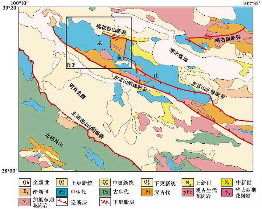 | 图 2 龙首山及周边地区地质简图(资料来源于 1︰50万青藏高原地质图)Fig. 2 Geologic map of Longshou Shan and adjacent region(modified after the 1︰500 000-scale geologic map of Tibet). |
位于龙首山北侧的桃花拉山断裂分隔了龙首山及其以北的潮水盆地(图 2), 控制了龙首山北缘的构造变形, 该断裂晚第四纪以来的垂直滑移速率为0.1~0.3mm/a, 水平滑移速率为0.14~0.93mm/a(Yu et al., 2017)。 断裂北侧的潮水盆地自中— 新生代以来构造较为稳定, 中、 新生代沉积地层的厚度最厚处超过2 000m(李翠等, 2011; 赵宏波等, 2013), 盆地北界北大山南缘断裂为NE向左旋走滑断裂(Darby et al., 2005; 陈文彬等, 2006; 俞晶星, 2016)。
磷灰石(U-Th)/He低温热年代学方法(AHe)具有较低的封闭温度(40~90℃), 可揭示样品通过部分保留带(AHe PRZ)之后的热历史(Farley et al., 2002)。 新生代以来, 构造活动造成的山脉抬升以及气候变化均可使地表剥蚀作用增强, 从而导致地壳浅层岩石快速地被剥露至地表(Reiners et al., 2006)。 因此, AHe低温热年代学方法不仅适合研究地壳浅层次的构造活动, 对于气候变形导致的地貌演变也较为敏感(Shuster et al., 2005), 同时也是目前国际上研究新生代构造与气候相互作用的重要方法(Burbank et al., 2003)。
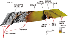
龙首山是祁连山北部与阿拉善地块南缘过渡带内侵蚀抬升强烈的山脉。 地貌上, 龙首山南陡北缓, 呈不对称形态(图 3)。 南部紧邻河西走廊盆地地区, 其海拔约1 500m; 山体向N快速抬升, 最高海拔达3 602m(Zheng et al., 2013b), 高差约1 750m。 龙首山南坡巨大的地貌高差为我们利用垂直剖面磷灰石(U-Th)/He样品年龄与高程关系揭示龙首山快速隆升的时间以及山脉剥露速率提供了可能。
 | 图 3 龙首山地质图与采样策略 a 龙首山西段地质简图(据甘肃省地质矿产局张掖幅、 山丹幅地质图), 剖面线PP′为图3c所在位置; b、 c 横向穿龙首山主峰的地质剖面图Fig. 3 Geologic map of Longshou Shan with sample locations. |
为了约束龙首山新生代的剥蚀历史, 本文利用磷灰石(AHe)年龄-高程剖面来确定其隆升年代。 我们在龙首山南、 北两侧共采集年代学样品14个, 其中在龙首山南坡采集样品11个, 在龙首山北坡采集样品3个(图 3)。 LS1、 LS2、 LS3、 LS8、 LS9、 LS10、 LS11、 N1、 N2和N3采集于华力西期花岗岩, LS4、 LS5、 LS6和LS7采集于石炭纪的砂岩或长英质岩脉中。 龙首山南侧样品采集的高程为1 790~3 256m, 样品采集的高差为100~200m(图3b, 表1), 而北侧样品采集的高程为2 300~3 160m, 样品采集的高差为200~300m(图3c, 表1)。
| 表1 龙首山样品的位置和AHe平均年龄 Table1 Sample location and Helium mean ages |
针对采集的14个样品, 首先将样品粉碎, 使用重液法分选出其中的重矿物, 然后使用磁吸法剔除重矿物中具有磁性的矿物, 在获得的非磁性重矿物中利用低倍显微镜挑选出磷灰石颗粒, 在中国地震局地质研究所地震动力学国家重点实验室进行AHe测试与分析。 测试的流程为: 1)在高倍双目镜以及正交偏光镜下挑选出自形的、 不含杂质、 包裹体且颗粒宽度≥ 60μ m的磷灰石晶体2~5粒, 对颗粒的长、 宽进行测量并拍照后, 利用铌筒将其包裹起来; 2)使用激光将颗粒置于2 000℃恒温下加热脱气释放4He, 随后加入已知含量的3He, 测定4He与3He的比值; 3)测定4He/3He后, 用20%的HNO3将磷灰石样品溶解, 并加入 235U 和 230Th 溶液对其进行标定; 4)利用Agilent 7900等离子质谱仪(ICP-MS)测得样品中U、 Th的含量; 5)通过实验测得的U、 Th、 Sm和4He的含量计算样品的AHe年龄并进行FT校正。 AHe年龄超过1σ 标准误差的样品则被舍弃(表2), 最终样品的AHe年龄是2~5个磷灰石颗粒样品经过检验后的平均年龄(表1)。
| 表 2 龙首山单颗粒AHe年龄 Table2 Single-grain AHe Dating Results |
垂直剖面法或磷灰石的AHe年龄-高程投影可以约束基岩剥露的历史, 反映断层的活动时间。 在采集样品处的水平距离相对较小、 垂直高差(> 1 000m)较大的情况下, 采样剖面可视为垂直剖面。 以样品AHe年龄为横轴、 高程为纵轴进行投图, 则斜率代表样品在其AHe年龄确定的时间段内的侵蚀速率, 年龄-高程剖面图中的拐点通常代表了一次热事件发生的时间(Farley et al., 2002; Reiners et al., 2006; 常远等, 2010)。 拐点以上的样品具有较低的剥露速率, 能够用来约束古部分保留带(Paleo-PRZ)的底限。 因此, 年龄-高程剖面图拐点之上的样品, 在缺乏地质标志层的区域可用于重建断层活动之前的古地貌(Clark et al., 2010; Zheng et al., 2010)。 根据样品距离古等温面的垂直距离可计算出样品相对古等温面的深度, 建立AHe年龄-深度图。 在多数情况下, 年龄-深度投影与年龄-高程投影相比能够排除断层上盘地表作用的影响, 从而更为准确地确定岩石的剥露速率(Clark et al., 2010)。
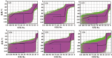
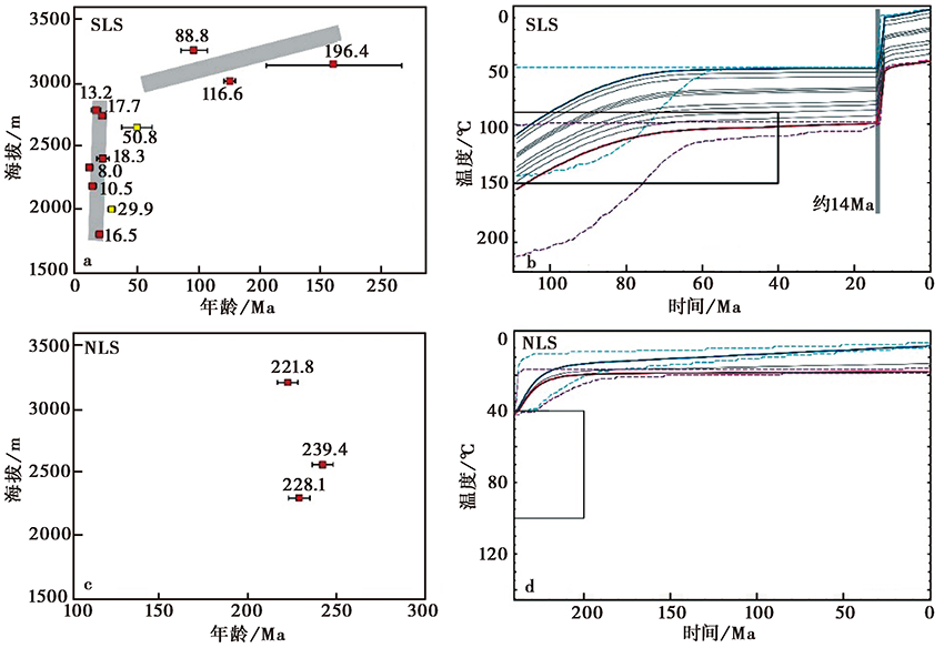
龙首山南缘断裂上盘11个样品的AHe年龄与高程投影图见图4a, 可以看出11个样品的年龄与高程明显呈正相关。 龙首山南坡样品的AHe年龄大体随着高度的升高而变老, 但是样品年龄随高程变化的斜率在海拔2 750m处出现显著差异: 海拔2 750m之下, 样品年龄为8Ma到17~13Ma; 而在海拔2 750m之上, 样品的年龄范围跨度更大, 约17~196.4Ma, 说明2 750m是龙首南坡样品年龄-高程变化的拐点, 其所对应的AHe年龄17~13Ma是在龙首山南缘断裂逆冲推覆作用下样品开始快速剥露的时间(图4a)。 海拔2 750m之下有2个样品的AHe年龄(LS2, LS6)较老, 为30~50Ma。 LS2为风化比较严重的花岗岩, 而LS6为粗砂岩, 磷灰石颗粒晶形并不完美, 磨圆度高, 这2个样品的(U-Th)/He体系可能没有完全封闭, 产生了异常高的AHe年龄(图4a)。
 | 图 4 龙首山南、 北坡样品测试结果的年龄-高程图 a 龙首山南部的年龄-高程图; b 龙首山南部的热历史反演图; c 龙首山北部的年龄-高程图; d 龙首山北部的热历史反演图。SLS 龙首山南坡剖面与热历史模拟剖面; NLS 龙首山北坡剖面与热历史模拟剖面Fig. 4 Age-elevation plot of the samples collected in the southern and northern slope of the Longshou Shan. |
来自龙首山北部的3个样品高程为2 300~3 160m, 但其AHe年龄相近, 为240~220Ma(图4c), 说明这3个样品可能在中生代时期处于同一深度, 是中生代龙首山等温面的残留。 依据龙首山现今北坡的地形, 可以推测这一等温面在中中新世时期由于龙首山南缘断层的活动而发生了N倾的掀斜。
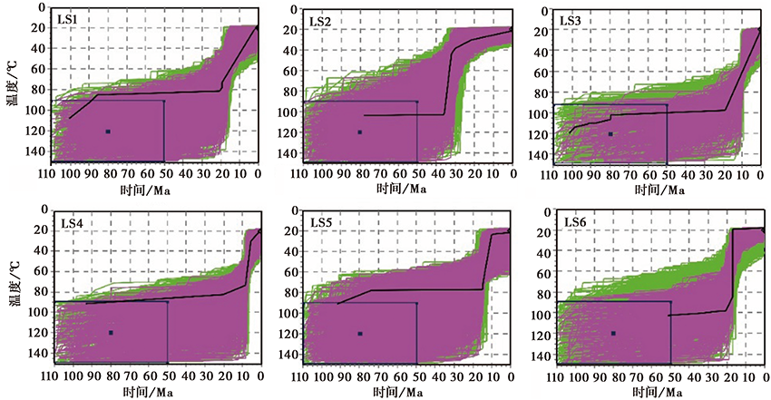
为进一步确定龙首山快速冷却事件的发生, 使用QTQt软件(v5.4.0)对龙首山北坡和南坡的样品分别进行了热史模拟(Gallagher, 2012)。 模拟初始条件设置为: 1)对龙首山南坡样品进行反演时, 设现今地表平均温度为(5± 2)℃; 根据已发表的龙首山南侧(Zhang et al., 2017)以及北祁连山东段(Pan et al., 2013)的磷灰石裂变径迹数据, 设置(80± 30)Ma BP的温度为(120± 30)℃(图4b); 2)对龙首山北坡样品进行反演热模拟时, 现今地表温度的设置与南坡相同。 由于北坡样品的AHe年龄大体接近, 设(220± 30)Ma BP的温度为(70± 30)℃, 从而确保样品能够模拟出更精确的热历史(图4d)。 如果所设置的温度范围覆盖了磷灰石裂变径迹方法的敏感范围, 则能获得早期可能的热历史路径(Wang Y et al., 2018); 3)对龙首山南、 北2个剖面平均进行了800 000次迭代, 确保模拟能够获得可靠的结果。
龙首山南坡(SLS)样品的反演结果如图4b所示。 结果显示, 白垩纪至中中新世(约14Ma BP)时期, 龙首山南坡的平均冷却速率较低, 说明在此期间龙首山南缘断裂处在构造平静期。 约14Ma BP以来, 龙首山南坡经历了一次快速冷却, 平均冷却速率约3.33℃/Ma, 几乎所有样品均被剥露至离地表较近的位置。 14~13Ma BP期间, 异常高的冷却速率说明中中新世以来龙首山南缘断裂强烈的构造活动导致岩石快速通过磷灰石(U-Th)/He的部分保留带。 与龙首山南坡不同, 北坡(NLS)采集的样品并未显示出任何新生代快速冷却事件。 早中生代时期(250~200Ma BP)龙首山北坡岩石的冷却速率较低, 为0.4℃/Ma, 之后岩石冷却速率也非常小(图4d)。
综上, 龙首山南坡剖面的模拟结果显示该地区岩石自约14Ma BP开始发生快速冷却, 而龙首山北坡剖面并没有经历中生代以来的显著降温时期, 表明龙首山约14Ma BP以来在其南缘断裂控制下发生N倾掀斜运动, 这与年龄-高程图所揭示的结果类似。
为进一步理解龙首山南部剖面拐点区域之下的8个样品的热演化历史, 我们使用HeFTy软件(v1.9.3)(Ketcham, 2005)对每个样品进行模拟: 1)对每个样品都使用了辐射损伤累积和退火模型(RDAAM)(Flowers et al., 2009); 2)反演时初始条件的设置与进行QTQt南部模拟时相同; 3)每个样品颗粒的模拟都进行了50 000次迭代, 获得的t-T路径中, 绿色实线代表可被接受的t-T路径, 其GOF参数≥ 0.05, 粉红色实线代表良好的t-T路径, 其GOF参数≥ 0.5, 而黑色粗实线代表最优路径, 其GOF参数≥ 0.95(Ketcham, 2005)。 图 5 选取了龙首山南坡6个样品的单颗粒模拟结果, 每个样品都显示了单一的冷却历史, 多数样品在17~14Ma BP时发生了快速冷却。 龙首山南坡的6个单颗粒模拟结果与南面的剖面模拟结果一致, 同时也与龙首山南部的年龄-高程图相符(图 5, 4a)。
 | 图 5 部分样品的单颗粒热模拟结果Fig. 5 Simulation results of the single-grain thermal histories. |
AHe高程剖面法所揭示的快速冷却过程可能是由断层活动或气候变化导致的。 在研究区南部, 西宁盆地高精度磁性地层学以及沉积岩相学的记录表明青藏高原东北部自始新世时期就处于干旱的环境(Dupont-Nivet et al., 2007; Fang et al., 2019); 循化盆地的沉积记录揭示该区域的气候约19Ma BP时由暖湿向寒冷干燥转变, 从14Ma BP开始, 干旱程度进一步加剧(Liu et al., 2019); 在祁连山内部, 党河区域的古生物学和地层学证据也表明高原东北部在渐新世— 中新世期间处于干旱— 半干旱环境(Wang et al., 2003); 研究区西部塔里木盆地的稳定同位素记录表明该区域从渐新世到至少晚中新世时期处于干旱环境(Graham et al., 2005)。
因此, 青藏高原东北部不同盆地中的沉积记录表明, 除一些局部区域有过短暂的湿润环境以外, 东北部从始新世— 晚中新世期间都处于干燥环境, 而这意味着地表风化作用较弱、 剥蚀速率低, 不太可能引起地表岩石的快速剥露。 相反, 中中新世之后, 高原东北部发生了广泛的构造运动, 断裂逆冲使地表抬升、 夷平面破坏, 盆地性质也发生转变(李奋其等, 2002; Yuan et al., 2013; Wang et al., 2016a)。 因此, 本文的AHe年龄-高程剖面所揭示的龙首山中中新世快速冷却事件不太可能是气候变化的结果, 而是由于龙首山自中中新世的快速抬升所致。
龙首山北坡3个样品的高程为2 300~3 160m, 高差为860m, 但其AHe年龄为221.8~239.4Ma, 年龄差异很小。 根据磷灰石(U-Th)/He低温热年代学方法的原理可知, 这3个样品通过部分保留带所经历的时间是相同的, 说明这3个样品点经历了相同程度的剥蚀。 由此可设想, 这3个样品可能在中生代时期处于同一深度, 它们所确立的面是中生代龙首山古等温面的残留。 该古等温面与现今龙首山北部的坡面基本一致, 根据龙首山现今北坡的地形可以看到这一等温面发生了向N的掀斜。 一般而言, 山脉越高的区域所经历的剥蚀程度越严重、 剥蚀速率越高, 这种情况下古等温面的高处将更易被剥蚀, 从而出露出新的地层, 也可能会使高处样品的AHe年龄比低处年轻。 本文中位于海拔3 160m处的样品N3的AHe年龄为228.1Ma, 比海拔2 575m处的样品N2年轻, 这从侧面佐证了古等温面的残留这一观点。
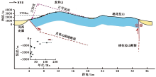
通过计算龙首山南坡11个样品点到该古等温面的垂直距离, 可描绘出龙首山磷灰石(U-Th)/He样品的年龄-深度剖面图(图 6)。 深度剖面图的结果同样揭示龙首山在17~13Ma BP开始快速冷却, 这一结果与龙首山磷灰石(U-Th)/He样品的年龄-高程分析结果一致, 也说明地表作用对样品的影响较弱, 冷却事件主要是由构造抬升引起的。 古等温残留面自中中新世以来逐渐向N倾斜这一变化态势表明, 龙首山在南缘断层的控制下自中中新世以来发生了向N掀斜隆升(图 6)。 这一时间与北祁连山中段17~15Ma BP的抬升时间基本吻合(Li et al., 2019; Yu et al., 2019), 说明龙首山与北祁连山中段可能是同时隆升的, 而高原东北部的扩展在中中新世时便已影响到阿拉善地块南部。
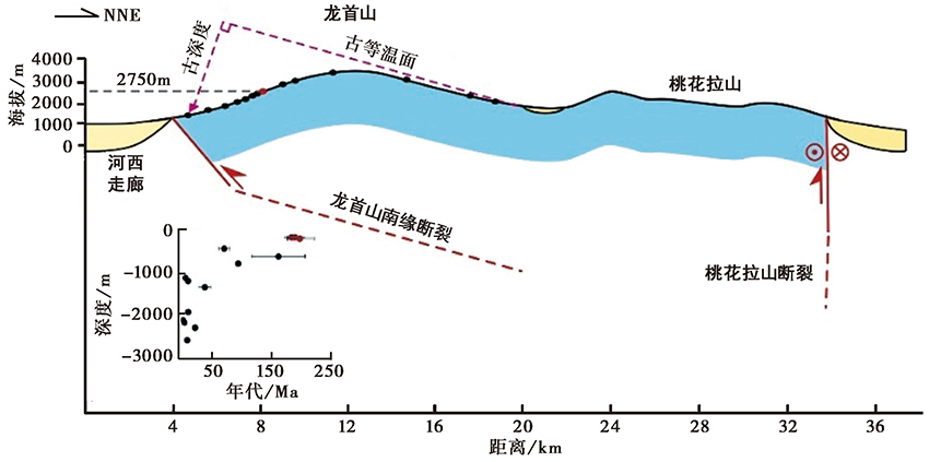 | 图 6 龙首山构造隆升模式图 龙首山在其南缘断层的控制下发生掀斜隆升, 左下图为根据北坡古等温面所作的年龄-深度图Fig. 6 The tectonic uplift mode of the Longshou Shan. |
龙首山北缘桃花拉山断裂晚第四纪以来的水平滑移速率为0.14~0.93mm/a, 垂直滑移速率为0.1~0.3mm/a(Yu et al., 2017), 山脉的平均海拔为2 400m, 潮水盆地的平均海拔约1 450m。 假定桃花拉山断裂新生代以来具有恒定的滑动速率(Hetzel et al., 2004; Palumbo et al., 2009; Zheng et al., 2013b), 桃花拉山要达到如今的高度, 则其开始隆升的时间应不早于9Ma BP, 估算其隆升时间应约为(6± 3)Ma。
根据龙首山南缘断裂约14Ma BP以来发生N倾掀斜抬升, 以及磷灰石(U-Th)/He热年代学体系的封闭温度40~90℃(Farley et al., 2002)、 地表温度10℃、 古地温梯度25~35℃/km(Zhang et al., 2017)和拐点区域距古等温面的深度约1km, 可计算出拐点在构造抬升前最多处于地下(2.9± 0.5)km深处。 拐点现今海拔为2 750m, 河西走廊西部的酒泉盆地13Ma之前的地层深度> 2 000m(方小敏等, 2004), 计算得到沿龙首山南缘断裂约14Ma BP以来的垂直抬升量最多为(5.6± 0.5)km。 由于龙首山在中中新世之前便为正地势, 故该结果是其垂直位移的最大估算值, 据此得到龙首山约14Ma BP以来的最大垂直抬升速率为(0.4± 0.04)mm/a。 龙首山南缘断裂这一活动速率与中新世以来北祁连山山前断裂的垂直活动速率约0.5mm/a基本一致(Zheng et al., 2010)。
深部地球物理资料显示, 海原-祁连断裂是高角度的走滑断裂, 北祁连山山前断裂上陡下缓, 呈低角度向N逆冲推覆, 二者会聚于地壳深部滑脱层, 总体构成向N逆冲推覆的断裂系(高锐等, 1995; Gao et al., 2013)。 上述断裂在中中新世时期发生了构造活动(Zheng et al., 2010; Zhuang et al., 2018; Li et al., 2019; Pang et al., 2019a; Yu et al., 2019)。 野外观测剖面显示, 龙首山南缘断裂向S逆冲, 现代地貌显示山前为高陡的山前洪积扇。 根据前人对断裂特征的调查研究结果, 结合本文所得到龙首山北坡为一年龄相近的古等温面的认识, 我们推测龙首山南缘断裂在深部倾角可能变缓, 近平行于龙首山北部坡面(图 6)。 地处阿拉善南缘的龙首山— 桃花拉山— 北大山可能整体组成了以龙首山南缘断裂为前缘、 向S逆冲的逆冲楔体, 近垂直的桃花拉山断裂和高角度的北大山走滑断裂构成了逆冲楔体后缘部分。 据此可知, 祁连山中段地区的构造变形是向N逆冲的祁连-海原断裂系与向S逆冲的龙首山-北大山断裂系之间的对冲变形模式, 北祁连山与龙首山在中中新世时期准同时发生快速隆升, 高原扩展的前峰此时也影响到了阿拉善地块南缘(图 7)。 高原东北部由于NE向的持续推挤和刚性阿拉善块体的阻挡而发生挤压缩短和顺时针旋转, 使得地壳物质侧向位移(袁道阳, 2003), 阿拉善地块南缘先存构造被激活, 并造成NW向断裂的逆冲和近EW向断裂的走滑兼逆冲(Yu et al., 2017)。 早期地球物理探测剖面综合解释结果认为, 阿拉善地块向S俯冲到了青藏高原东北部之下(高锐等, 1995), 现今的多种地球物理手段也揭示出这一现象(Ye et al., 2015; 黄兴富等, 2018), 出现这种情况的原因可能是青藏高原不断向N楔入造成了阿拉善地块向S的被动俯冲(黄兴富等, 2018), 使得河西走廊北部、 阿拉善地块南缘的龙首山成为挤压会聚的前缘, 形成了北祁连山中段与阿拉善地块南缘之间上地壳或更浅深度上的挤压对冲模式。
祁连山中段的这种扩展方式与其西段和东段不同。 北祁连山西部前陆玉门— 酒泉— 张掖盆地为前陆逆冲型盆地(Zheng et al., 2013b), 同时托莱山自17~14Ma BP开始隆升(Zheng et al., 2017), 北祁连山山前断裂西段在20~10Ma BP开始活动(George et al., 2001; Bovet et al., 2009; Zheng et al., 2010; Zhuang et al., 2018), 老君庙背斜在5~4Ma BP开始变形(Fang et al., 2005), 合黎山断裂则于约2Ma BP开始活动(Zheng et al., 2013b), 这一系列NWW走向、 S倾的构造控制着新生代凹陷的形成和演化, 从南到北的活动时间越来越年轻, 表现为向N的前展式推覆运动(李奋其等, 2002)。 如本文所示, 祁连山中部地区从海原断裂西段(17~15Ma BP)(Li et al., 2019; Yu et al., 2019)到龙首山南缘断裂(约14Ma BP)、 桃花拉山断裂(约6Ma BP)发生了对冲式向N扩展(图 7)。 而东北部、 东部地区则形成以左旋走滑为主、 兼具NE向逆冲的弧形构造带; 该地区由于受到南部NE向的持续挤压, 再加上北部鄂尔多斯地块和阿拉善地块的共同阻挡, 表现为以次级地块为主体、 地块边界断裂早期向NE挤压、 后期转为左旋走滑的块状扩展模式(Wang et al., 2014; Lei et al., 2016)。
 | 图 7 北祁连山— 北大山对冲模式向N扩展简图(资料参考Zheng et al., 2013a和Yu et al., 2017)Fig. 7 Hedged-northward-spreading graph of North Qilian Shan-Beida Shan(after Zheng et al., 2013a and Yu et al., 2017). |
综合上述观点, 我们认为受控于祁连山内部的一系列NWW向逆冲断裂, 北祁连山中段在中中新世时首先发生快速抬升, 并向N扩展影响到了阿拉善地块南缘, 而北祁连山的东段和西段的抬升时间相对年轻, 且祁连山自西向东的不同地段表现出了不同的变形模式: 西部为前展式运动扩展; 中部在早期准同时隆升过程中表现出对冲式变形的特征, 后期表现为向NE逐步扩展; 东部显示为次级块体扩展挤出。
本文利用磷灰石(U-Th)/He热年代学方法确定了北祁连山以北龙首山开始隆升的时间。 从龙首山南缘逆断层和龙首山北缘逆断层采集的AHe样品的测年结果显示, 中中新世以来(约14Ma BP)龙首山南缘的逆断层强烈活动, 控制了龙首山的N倾掀斜抬升, 这一时间与北祁连山中部开始隆升的时间基本一致, 而龙首山北缘断层在这一时期的活动性较弱, 龙首山北坡表现为缓慢掀斜, 受青藏高原NE向扩展的影响, 使河西走廊北部龙首山成为挤压会聚的前缘, 龙首山— 桃花拉山— 北大山一起构成了阿拉善地块向S逆冲的断裂体系, 形成了北祁连山中段与阿拉善地块南缘之间上地壳或更浅深度上的挤压对冲模式。 另外, 结合地球物理、 新生代变形等的资料分析认为, 自中新世以来, 青藏高原东北缘在NWW向断裂的控制下发生地壳增厚缩短, 其NE向扩展已经影响到阿拉善地块南部, 并造成阿拉善南缘先存断裂的活化。
致谢 张会平研究员、 郑德文研究员、 吴传勇研究员以及李志刚研究员对本文提出了建设性建议; 俞晶星博士、 熊建国博士和庞建章博士为本研究提供了很多有益的资料; 梁淑敏博士为本文的修改提供了很大帮助; 审稿人提出的建设性的意见和建议对文章的完善和提升具有重要作用。 在此一并表示感谢!
| [1] |
|
| [2] |
|
| [3] |
|
| [4] |
|
| [5] |
|
| [6] |
|
| [7] |
|
| [8] |
|
| [9] |
|
| [10] |
|
| [11] |
|
| [12] |
|
| [13] |
|
| [14] |
|
| [15] |
|
| [16] |
|
| [17] |
|
| [18] |
|
| [19] |
|
| [20] |
|
| [21] |
|
| [22] |
|
| [23] |
|
| [24] |
|
| [25] |
|
| [26] |
|
| [27] |
|
| [28] |
|
| [29] |
|
| [30] |
|
| [31] |
|
| [32] |
|
| [33] |
|
| [34] |
|
| [35] |
|
| [36] |
|
| [37] |
|
| [38] |
|
| [39] |
|
| [40] |
|
| [41] |
|
| [42] |
|
| [43] |
|
| [44] |
|
| [45] |
|
| [46] |
|
| [47] |
|
| [48] |
|
| [49] |
|
| [50] |
|
| [51] |
|
| [52] |
|
| [53] |
|
| [54] |
|
| [55] |
|
| [56] |
|
| [57] |
|
| [58] |
|
| [59] |
|
| [60] |
|
| [61] |
|
| [62] |
|
| [63] |
|
| [64] |
|
| [65] |
|
| [66] |
|