


鲜水河断裂带雅拉河段晚第四纪活动性
[梁明剑2, 3)  , 陈立春
, 陈立春1, 3), * , 冉勇康3) , 李彦宝3) , 王栋4) , 高帅坡3) , 韩明明3) , 曾蒂3) ]
, 陈立春, 冉勇康|
|


〔作者简介〕 梁明剑, 男, 1979年生, 2019年于中国地震局地质研究所获构造地质学专业博士学位, 主要从事活动构造、 中长期地震预测方面的研究, 电话: 028-85447105, E-mail: 23800794@qq.com。
走滑断裂几何结构的复杂性往往影响着断裂上的应变积累与分配、 大地震的破裂过程等。 鲜水河断裂带是青藏高原东南缘一条强烈活动的次级块体边界断裂带, 其在惠远寺—康定之间叉分为3支次级断层: 雅拉河断层、 色拉哈断层和折多塘断层。 前人认为这3条断层不均匀地分配了鲜水河断裂慧远寺以北段的应变。 然而, 关于雅拉河断层晚第四纪活动性的分歧制约了对这种应变分配模式的认识。 文中通过遥感解译和野外调查发现: 在雅拉措一带仍残留有一段长约10km的地震地表破裂带, 同震水平位错2.5~3.5m; 断层晚第四纪地表活动行迹一直向S延至雅拉乡附近。 这些证据表明雅拉河断层为全新世活动断层, 与色拉哈断层、 折多塘断层一样具有孕育和发生强震、 大地震的构造能力, 同样参与鲜水河断裂带的应变分配。
, CHEN Li-chun, RAN Yong-kangComplex geometrical structures on strike-slip faults would likely affect fault behavior such as strain accumulation and distribution, seismic rupture process, etc. The Xianshuihe Fault has been considered to be a Holocene active strike-slip fault with a high horizontal slip rate along the eastern margin of the Tibetan plateau. During the past 300 years, the Xianshuihe Fault produced 8 earthquakes with magnitude≥7 along the whole fault and showed strong activities of large earthquakes. Taking the Huiyuansi Basin as a structure boundary, the northwestern and southeastern segments of the Xianshuihe Fault show different characteristics. The northwestern segment, consisting of the Luhuo, Daofu and Qianning sections, shows a left-stepping en echelon pattern by simple fault strands. However, the southeastern segment(Huiyuansi-Kangding segment)has a complex structure and is divided into three sub-faults: the Yalahe, Selaha and Zheduotang Faults. To the south of Kangding County, the Moxi segment of the Xianshuihe Fault shows a simple structure. The previous studies suggest that the three sub-faults(the Yalahe, Selaha and Zheduotang Faults of the Huiyuansi-Kangding segment)unevenly distribute the strain of the northwestern segment of the Xianshuihe Fault. However, the disagreement of the new activity of the Yalahe Fault limits the understanding of the strain distribution model of the Huiyuansi-Kangding segment. Most scholars believed that the Yalahe Fault is a Holocene active fault. However, Zhang et al.(2017)used low-temperature thermochronology to study the cooling history of the Gongga rock mass, and suggested that the Yalahe Fault is now inactive and the latest activity of the Xianshuihe Fault has moved westward over the Selaha Fault. The Yalahe Fault is the only segment of the Xianshuihe Fault that lacks records of the strong historical earthquakes. Moreover, the Yalahe Fault is located in the alpine valley area, and the previous traffic conditions were very bad. Thus, the previous research on fault activity of the fault relied mainly on the interpretation of remote sensing, and the uncertainty was relatively large. Through remote sensing and field investigation, we found the geological and geomorphological evidence for Holocene activity of the Yalahe Fault. Moreover, we found a well-preserved seismic surface rupture zone with a length of about 10km near the Yariacuo and the co-seismic offsets of the earthquake are about 2.5~3.5m. In addition, we also advance the new active fault track of the Yalahe Fault to Yala Town near Kangding County. In Wangmu and Yala Town, we found the geological evidence for the latest fault activity that the Holocene alluvial fans were dislocated by the fault. These evidences suggest that the Yalahe Fault is a Holocene active fault, and has the seismogenic tectonic condition to produce a large earthquake, just like the Selaha and Zheduotang Faults. These also provide seismic geological evidence for the strain distribution model of the Kangding-Huiyuansi segment of the Xianshuihe Fault.
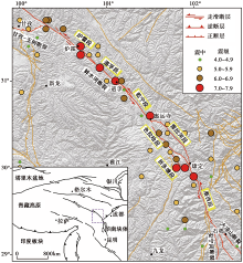
走滑断裂几何结构的复杂性往往影响断裂的应变积累与分配、 大地震的破裂过程等方面(Duan et al., 2005, 2006)。 断裂的转折弯曲和阶区可作为断裂破裂分段的边界, 控制地震破裂的起始、 扩展和终止, 从而限定地震的震级大小(Harris et al., 1999; Duan et al., 2005; Wesnousky, 2006; Wen et al., 2008); 而分支断裂则可能会不均匀地分配主断裂的滑动速率, 导致滑动速率沿走向方向呈梯级递减(闻学泽等, 1989; Dolan et al., 2007; Kirby et al., 2007; 李陈侠等, 2011; Chen et al., 2016)。 鲜水河断裂带是青藏高原内部强烈活动的巴颜喀拉次级块体的SE边界断裂带, 在青藏高原东缘的构造演化和现今的活动样式中承担着重要角色。 自1700AD有地震记载以来, 沿鲜水河断裂带共记录了7级以上地震8次, 6.5级以上地震15次, 地震地表破裂带几乎覆盖了整条断裂的各个段落, 这使得鲜水河断裂成为研究地震预测和灾害的最理想的对象之一(Allen et al., 1991)。
以惠远寺盆地为界, 鲜水河断裂呈现出NW和SE 2个结构特征不同的段落(闻学泽等, 1989; 唐荣昌等, 1993; 李天祒等, 1997): NW段表现出总体比较单一的几何结构特征, 由炉霍段、 道孚段和乾宁段3条次级断层左阶羽列而成。 SE段的几何结构复杂, 惠远寺— 康定段分为3支次级断层: 雅拉河断层、 色拉哈断层和折多塘断层; 在康定以南断裂又呈单一几何结构向S延伸(图1)。
 | 图 1 鲜水河断裂的几何展布及其强震分布图Fig. 1 The geometry and strong earthquakes distribution of the Xianshuihe Fault. |
其中, 色拉哈断层和折多塘断层的地表行迹清晰, 历史上沿色拉哈断层曾发生过1725年7级和1748年6¾ 级地震, 折多塘断层则发生过1955年7.5级地震(Allen et al., 1991; 李天祒等, 1997; Wen et al., 2008)。 雅拉河断层是鲜水河断裂带惟一缺乏历史地震记录的段落, 关于其晚第四纪的活动性也一直存有争议。 大多数学者认为雅拉河断层为全新世活动断层, 与色拉哈断层和折多塘断层一同分配了鲜水河断裂NW段的高滑动速率(闻学泽等, 1989; 周荣军等, 2001; Chen et al., 2016)。 Zhang等(2017)采用低温热年代学方法研究了贡嘎岩体的冷却历史, 认为鲜水河断裂运动的起始时间与康定岩体开始快速剥蚀的时间一致, 为9Ma之前; 而雅拉河断层现今已不再活动, 其活动时代为4~9Ma BP, 鲜水河断裂带的最新活动已西迁至色哈拉断层上。 显然, 雅拉河断层在全新世是否活动、 是否与色拉哈断层和折多塘断层一样也具有独立孕育和发生大地震的构造能力等, 是认识鲜水河断裂带惠远寺— 康定段应变传递与分配的关键问题之一。
鲜水河断裂强震、 大地震活动频繁, 一直以来被认为是高滑动速率的左旋走滑断裂。 例如, 康定的侵入岩体被鲜水河断裂左旋断错的总位移量约60km(Wang et al., 1998), 根据康定岩体的形成年龄(4~13Ma)(Roger et al., 1995; Wang et al., 1998; Yan et al., 2017; Zhang et al., 2017)估算得到的鲜水河断裂长期的水平滑动速率为4.6~15mm/a。 对于晚第四纪时间尺度的滑动速率, 不同学者通过阶地、 冲沟、 冰碛垄等地貌体的位错及其年龄, 获得鲜水河断裂NW段的平均水平滑动速率为(9.5± 1.5)~(17± 3)mm/a(Allen et al., 1991; 李天祒等, 1997; Zhang, 2013; Chen et al., 2016)。 而GPS和InSAR的解算结果显示鲜水河断裂的水平滑动速率大多为10~15mm/a(王敏等, 2003; 张培震等, 2003; Gan et al., 2007; Zhang, 2013; Xu et al., 2016)。 不过, 也有学者得到的滑动速率要小得多。 England等(2005)获得的鲜水河断裂的GPS水平滑动速率为7mm/a, 并认为该速率为断裂的上限速率; 而李东雨(2016)在断裂NW段的龙灯乡利用古地震序列和同震位错限定的晚更新世晚期以来的滑动速率< 3mm/a。 鲜水河断裂惠远寺— 康定段叉分为3支次级断层: 雅拉河断层、 色拉哈断层和折多塘断层, 其中通过地质学方法获得的色拉哈断层的水平滑动速率为(5.5± 0.6)~10.7mm/a(李天祒等, 1997; 周荣军等, 2001; Chen et al., 2016; Yan et al., 2017; Bai et al., 2018), 折多塘断层的水平滑动速率为3.6~6mm/a(李天祒等, 1997; 周荣军等, 2001)。 色拉哈断层历史上曾发生过1725年7级和1748年级地震, 折多塘断层则发生过1955年7.5级地震(Wen et al., 2008)。 此外, 色拉哈断层于2014年发生了6.3级地震, 随后促使折多塘断层也发生了5.8级地震(易桂喜等, 2015), 这表明两者不仅具有独立孕育、 发生强震的构造能力, 而且存在相互作用。
关于雅拉河断层, 有学者认为其晚第四纪以来的水平滑动速率为1~3mm/a(闻学泽等, 1989; Chen et al., 2016), 并参与分配了鲜水河断裂NW段的滑动速率(闻学泽等, 1989; Chen et al., 2016); 也有学者认为该断层已不再活动, 断层的新活动已转移到色哈拉断层上(Zhang et al., 2017)。 认为雅拉河断层活动的学者, 其认识也存在一定的分歧。 李天祒等(1997)认为雅拉河断层的新活动仅限于新店子— 丹巴公路的二道班之间; 周荣军等(2001)认为断层的新活动截止于新店子南边的王母村附近。 雅拉河断层北段位于雅拉雪山东侧, 需徒步穿过原始林区才能到达断层所在之处, 交通极为困难; 而南段沿着雅拉沟展布, 由于地处深切沟谷, 剥蚀强烈, 从而导致断层新活动的行迹并不明显。 也许由于交通条件极其不便, 在前人公开发表的成果中, 尚未见确切的断层活动的地质地貌照片, 断层的行迹大多靠卫星影像进行遥感解译, 这可能是认识存在分歧的主要原因之一。
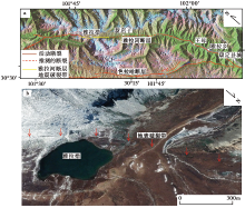
雅拉河断层在雅拉措一带线性影像特征清晰, 地表调查发现这一带仍残留有长约10km的同震地表破裂带, 破裂带沿着雅拉措2个海子的西侧山脚向S、 N两侧延伸, 切过一系列冲沟、 冰水堆积台地、 倒石碓等(图2)。
 | 图 2 雅拉河断层及其地震地表破裂带分布图 a 雅拉河断层展布图, 地图为ETM影像; b 雅拉措一带的地表破裂带行迹, 底图为Google Earth影像Fig. 2 The geometry of the Yalahe Fault and the seismic surface rupture on it. |
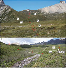
在雅拉措可见南、 北2个海子, 其北侧断裂切过T1、 T2和T3 3级台地, 将台地侧缘和冲沟左旋位错, 台地上形成小的断层槽微地貌(图3a)。 其中, T2为冰碛、 冰水堆积台地, 其NW缘被左旋位错约15m(图3b); 而T1台地为冰水堆积台地, 由于后期冲蚀比较严重, 未能识别出确切的左旋位错量。 由于地震导致的张裂隙后期形成小槽谷(图4a), 并堆积了线性排列的滚石, 再向SE破裂带切山脚而过, 形成反向槽谷(图4b)。
 | 图 3 雅拉措北冲沟及冰水堆积台地断错地貌 a 断裂断错了T1— T3台地; b 断裂断错T2台地侧缘约15m, 白色矩形为取样位置Fig. 3 The gully and glaciofluvial platform dislocated by the fault in the north of Yalacuo. |
 | 图 4 雅拉措T1台地的地表破裂带 a 地表破裂带行迹; b 地表破裂形成的小槽谷, 底部堆积线性排列的石块Fig. 4 The seismic surface rupture zone on T1 terrace near Yalacuo. |
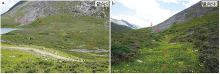
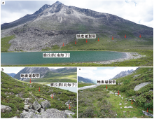
 | 图 5 雅拉措南侧的地表破裂带 a 雅拉措南侧的地表破裂带沿着雅拉雪山的山脚展布; b 地表破裂带在山脚形成反向陡坎; c 地表破裂形成小槽谷, 堆积线性滚石, 滚石甚至直立排列Fig. 5 The seismic surface rupture on the south of Yalacuo. |
沿着山脚破裂带追索, 可见在山脚形成反向槽谷和地震鼓包、 滚石堆被左旋位错、 滚石楔入张性裂缝呈陡立状线性排列等微地貌现象(图5)。 其中, 一系列从山上滚下来的滚石堆被切过的断裂左旋位错, 左旋水平位错量分别为3.3m、 2.8m和3.5m(图6a— c); 还有一垂直于断裂迹线的坡脊被左旋位错约2.5m(图6d)。 这些左旋水平位错量应该是雅拉河断层最晚一次地震事件的同震位错量, 根据邓起东等(1992)统计的地震震级和最大同震位错的关系(式(1))可估算该次地震的震级为7.0~7.5级。
式中, M为地震震级, Dmax为最大同震位错(单位: m)。
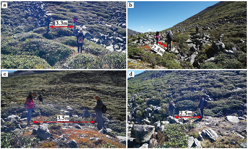 | 图 6 雅拉措南侧的同震位错 a、 b、 c 滚石堆分别被左旋位错约3.3m、 2.8m和3.5m; d一垂直破裂带的坡脊侧缘被左旋位错约2.5mFig. 6 The co-seismic offsets on the south of Yalacuo. |
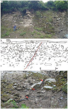
我们在雅拉措(北海子)北侧T2台地上的地表破裂形成的浅槽边上的顶部开挖一剖面, 剖面揭露了2套地层(图7):
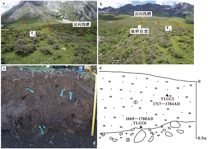 | 图 7 雅拉措T2台地破裂带残留的浅槽及取样剖面 a、 b 破裂带在T2台地面上形成反向浅槽; c、 d 取样剖面。地层: ①深褐色砂土层; ②略泛黄色砾石层。 年代样品由美国Beta实验室测定, 结果经校正Fig. 7 The fault shallow groove and sampling section on the T2 terrace near Yalacuo. |
①深褐色含砾砂土层, 富含植物根系和有机质; ②略泛黄色的砾石层, 砾石磨圆差, 呈棱角状。 同时, 分别于地层①上部和底部取了2个14C样品(炭屑)YLGC3和YLGC6, 其测年结果分别为1717— 1784cal AD和1669— 1780cal AD。 地震破裂带切过T2台地面, 现在仍可清晰地辨识出台地面上地表破裂形成的反向浅槽, 表明T2台地面顶部的砂土层堆积之后发生过地震, 因此地震应发生于地表砂土层沉积之后, 即1669— 1780cal AD之后。
雅拉河断层向S, 周荣军等(2001)在王母村的Ⅱ 级冲洪积台地上发现2道断层陡坎, 并认为雅拉河断裂终止于王母村附近。 我们也在王母村土路发现一断层剖面, 地貌为Ⅱ 级冲洪积台地, 剖面显示断层断错了Ⅱ 级台地的冲洪积砾石层(图8)。 根据前人的测年结果(李天祒等, 1997)和周荣军等(2001)在王母村Ⅱ 级冲洪积台地上开挖探槽的底部年龄结果可知, 雅拉沟一线的Ⅱ 级冲洪积扇形成于全新世早中期, 也表明雅拉河断层在王母村一带仍显示出全新世活动性。
 | 图 8 王母村雅拉河断层的照片及剖面 a、 b 断层照片和剖面; c 砾石定向排列的局部照片。地层: ①深褐色砂土层, 含砾石; ②冲洪积砾石层, 砾石磨圆差Fig. 8 The fault photos and section of the Yalahe Fault near Wangmu Village. |
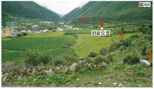
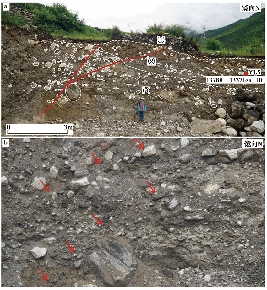
雅拉河断层在雅拉乡一带具有较好的线性行迹, 断层切过垃圾场两侧的山脊形成垭口地貌; 继续向S, 断层切过雅拉河西岸的Ⅱ 级冲洪积台地, 虽受到人为改造, 但台地上仍可见断续线性陡坎(图9)。 于雅拉乡头道桥村修往采石场的路上可见一断层剖面被揭露, 断层断错了Ⅱ 级台地的冲洪积层, 导致砾石沿着断裂定向排列, 地层出现一定程度的褶皱变形, 断层活动性质具有一定的垂直运动分量(图10)。 剖面揭露了3套地层: ①人工堆积的砂砾层和砂土层; ②砂砾层; ③砾石层。 断层向上断错了地层②, 在该层获得的14C样品YL5的测年结果为13788— 13371cal BC(图10)。 雅拉河一线的Ⅱ 级冲洪积扇形成于全新世早中期, YL5的年龄结果可能偏老。 综上所述, 雅拉河断层向S延伸至雅拉乡一带, 仍表现出全新世的新活动性。
 | 图 9 雅拉乡附近的雅拉河断层地貌Fig. 9 The fault landscape of the Yalahe Fault near Yala Town. |
 | 图 10 雅拉乡的雅拉河断层剖面 a 雅拉乡雅拉河西岸冲洪积台地断层的地貌; b 断层剖面局部照片, 可见砾石定向排列。①人工堆积的砂砾层和砂土层; ②砂砾层, 略具层理, 砾石粒径相对较小、 磨圆好; ③砾石层, 充填粗砂, 砾石粒径较大, 磨圆较好Fig. 10 The fault photos and section of the Yalahe Fault near Yala Town. |
活动断裂的复杂结构很大程度上影响了断裂(段)的应变积累、 传递与分配过程, 从而制约了断裂(段)的强震、 大地震破裂行为。 例如, 川滇块体东边界的鲜水河断裂在石棉一带分为大凉山断裂(东支)和安宁河-则木河断裂(西支), GPS观测的位移场和地震地质研究获得的断层滑动速率均表明大凉山断裂和安宁河-则木河断裂可能分配了鲜水河断裂的水平位移场(Shen et al., 2005; 何宏林等, 2008; 冉勇康等, 2008; 王阎昭等, 2008; 魏占玉等, 2012)。 然而, 自有史料记载以来, 大凉山断裂迄今尚未发生过6级以上强震, 出现了与鲜水河断裂、 安宁河-则木河断裂强震活动周期不同步的现象。
鲜水河断裂惠远寺— 康定段可分为雅拉河断层、 色拉哈断层和折多塘断层, 前人认为这3条断层不均匀地分配了鲜水河断裂NW段的应变(闻学泽等, 1989; 周荣军等, 2001; Chen et al., 2016)。 然而, 关于雅拉河断层新活动性的分歧(Zhang et al., 2017)制约了这种应变分配模式的认识。 本文不仅确认了雅拉河断层全新世的新活动性, 而且还发现了在其北段保存较好的地震地表破裂。 在雅拉措一带, 雅拉河断层上仍有一段长约10km的保存较好的地震地表破裂带。 该次地震的同震位错为2.5~3.5m, 由经验公式估算其震级为7.0~7.5级, 发生在1669— 1780cal AD之后, 结合前人的结果(周荣军等, 2001; Wen et al., 2008; Bai et al., 2018)推测, 该次地震可能是1700AD地震。
新发现的地震地质与地貌证据表明, 雅拉河断层与色拉哈断层、 折多塘断层一样具有孕育和发生强震、 大地震的构造能力, 这也证明了这3条断层具备参与分配鲜水河断裂NW段水平滑动速率的构造条件。 也有学者认为惠远寺— 康定段的3条次级断层在地壳深部为一整体, 具有统一的断裂面, 而在地表3条断层呈现出深部断裂错动的尾端效应(周荣军等, 2001)。 我们在雅拉河断层上发现了地震地表破裂带, 估算的震级达7.5级, 可能是1700AD地震; 而色拉哈断层和折多塘断层分别曾发生过1725年7级、 1955年7.5级地震(Allen et al., 1991; 李天祒等, 1997; Wen et al., 2008), 这表明雅拉河断层与色拉哈断层、 折多塘断层均具有独立孕育和发生强震、 大地震的构造能力。 如果雅拉河断层、 色拉哈断层与折多塘断层发生强震、 大地震均是惠远寺— 康定段深部断裂错动的地表表现, 那么如何解释3条断层产生的地表破裂存在不同?惠远寺— 康定段是否具有发生特大地震导致这3条断裂在地表同时发生破裂的构造能力?综上所述, 鲜水河断裂惠远寺— 康定段的雅拉河断层、 色拉哈断层与折多塘断层深部的构造环境如何, 深、 浅构造耦合关系如何等问题仍需要进一步深入研究。
本文的研究表明, 雅拉河断层不仅具有全新世的新活动性, 而且具有孕育和发生强震、 大地震的构造条件, 与色拉哈断层、 折多塘断层一起不均匀地分配了鲜水河断裂NW段的应变。
| [1] |
|
| [2] |
|
| [3] |
|
| [4] |
|
| [5] |
|
| [6] |
|
| [7] |
|
| [8] |
|
| [9] |
|
| [10] |
|
| [11] |
|
| [12] |
|
| [13] |
|
| [14] |
|
| [15] |
|
| [16] |
|
| [17] |
|
| [18] |
|
| [19] |
|
| [20] |
|
| [21] |
|
| [22] |
|
| [23] |
|
| [24] |
|
| [25] |
|
| [26] |
|
| [27] |
|
| [28] |
|
| [29] |
|
| [30] |
|
| [31] |
|
| [32] |
|
| [33] |
|