


活动褶皱地区横向河演化与风口形成的研究进展和案例分析
[曹喜林1, 2  , 耿豪鹏
, 耿豪鹏1, * , 潘保田1 , 胡小飞1 ]
, 耿豪鹏, 潘保田|
|


作者简介:曹喜林, 男, 1989年生, 2019年于兰州大学获第四纪地质学博士学位, 现为南京师范大学自然地理学博士后, 研究方向为河流地貌与新构造运动, E-mail: caoxl15@lzu.edu.cn。
河流偏转和风口发育是横向河流域最显著的地貌现象, 其形成体现着区域抬升和河流侵蚀间的平衡, 并受控于断层侧向生长、 连接与几何形态等构造过程以及影响河流侵蚀的气候和岩性要素。 风口与横向河网的演化可用于评估相关断层活动的速率和方式, 探索河流侵蚀与构造抬升之间的相互作用以及复杂环境下沉积系统的形态, 研究成果对地貌学、 地震灾害、 油气储藏等学科领域具有重要的理论意义。 文中围绕影响风口形成与保存的地质地貌过程, 对过去20a活动褶皱区域的横向河演化研究案例进行了初步总结。 最后以河西走廊地区的合黎山-金塔南山为例, 探讨在褶皱隆起和水动力变化的条件下黑河在该区域的演化过程。 分析认为现代黑河约1.1Ma BP穿过合黎山, 而随着合黎山的生长、 黑河水动力条件的变化, 黑河偏转到达金塔南山区域; 由于合适的水沙比与抬升速率, 金塔南山区域早期抬升时处于夷平状态; 约0.23Ma BP以来, 大部分支流无法到达金塔南山区域, 黑河在金塔南山与合黎山连接的区域下切, 形成正义峡。
The most compelling phenomena for transverse drainage in active fold belt are lateral diversion of channels and development of water/wind gaps. This phenomenon is the result of competition between uplift and erosion, which is controlled by fault vertical/lateral propagation and segment linkage, fault geometry, climate condition and lithology. Previous studies found that the higher the uplift rate is, the greater number of wind gaps form, and the variation of the uplift rate is also critical to the sustainability of transverse rivers. Lateral propagation and linkage of several separate folds in fold-and-thrust belts will lead to defeat of streams and diversion into a trunk drainage; if the trunk is still unable to keep pace with uplift, water gap will be abandoned and left as a wind gap. For lateral propagation of an anticline associated with development of tear faults, the locations of wind/water gaps are likely to coincide with the trace of tear fault and it's not quite clear about the relation between tear faulting and stream deflection. Nonzero dip of the underlying detachment induces a lateral surface slope in the direction of fault propagation, which in turn makes rivers deflection more efficient. Climate and rock erodibility control the water/sediment discharge, and further influence river transport/incision capacity. The changing climate and rock erodibility conditions enable river to abandon the current waterway to create a wind gap unless they could down-cut through a growing fold. However, the role of climate cycle in the formation of wind gap is still controversial. In addition, wind gaps are commonly developed along the divides where parts of longitudinal river have been captured by transverse catchments. Generally, the development of transverse drainages and the formation of wind gaps in nature are result from a combination of tectonic and fluvial process. The wind gap pattern and transverse drainage evolution in fold-and-thrust belts contain plenty of information on fault growth, interaction between tectonic uplift and fluvial erosion, and development of sedimentary basin. Such researches have significant implications in geomorphology, seismic hazard assessment and hydrocarbon exploration. However, there are still many knowledge gaps on the study of transverse river evolution in active fold areas. First, adequate chronology and geomorphic/strata mark to quantify fold growth and erosion is commonly not available, which leads to a poorly constrained rate in both river incision and lateral propagation of growing folds. In addition, more geological and geomorphological processes could influence the evolution of transverse drainages. For examples, (1)during the formation of a young range or anticline, the mechanism of fault-related folding may change over time, e.g. from fault-propagation folding to surface breaking; (2)Besides the knickpoint retreat in downstream, efficient lateral planation and downstream sweep erosion are also important in understanding the erosion of folds by rivers flowing through it. These processes make the development of transverse drainage across folds more complex and should be considered in more comprehensive models. There are lots of rivers originating from the Tibetan plateau and cutting through young surrounding mountains. These surrounding mountains, such as Qilian Mountains, Tianshan Mountains and Longmen Mountains, are ideal areas for the study of transverse river evolution and wind gap formation. In the end, combining with the geological and geomorphological features of the Heli Shan-Jintanan Shan, north of Hexi Corridor, we propose that the Heihe River has experienced deflection, beveling and incision since Mid Pleistocene. These processes have led to 1)the formation of a wind gap on the western Heli Shan, 2)a layer of fluvial gravels from the Qilian Shan preserved on the top surface of the Jintanan Shan, and overlying angular unconformity upon older strata, and 3)the incision of the Heihe River to form the Zhengyi Gorge through the linked structure between Heli Shan and Jintanan Shan. Thus, we propose a general model for the development of transverse drainages in the central Hexi Corridor: deflection-beveling-incision.
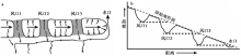
河流穿过抬升区域时可通过侧向夷平蚀低地形(Scharer et al., 2006), 也可通过垂向下切塑造陡峭的河谷并组建横向河网(Lavé et al., 2001), 而当河流的侵蚀能力无法与山体抬升速度相匹配时就可能导致水口被废弃(Sobel et al., 2003)。 风口(wind gaps, 图 1)即被遗弃的横向河水口(water gaps), 是横向河发育过程中构造变形与河流侵蚀过程之间相互竞争的产物, 其形成机制与控制因素一直以来都是构造地貌学关注的焦点问题之一。
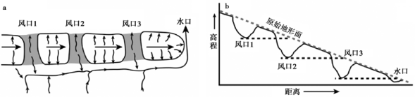 | 图 1 系列的风口与水口(据Keller et al., 2013修改) a 平面示意图, 褶皱向右侧传播, 长度和高度不断增加, 迫使河道向褶皱边缘迁移, 并保留逐渐年轻的风口(风口1-3); b 与图a对应的剖面示意图, 风口底部的水平线与原始地形面相交的区域对应更年轻的风口、 水口位置Fig. 1 A series of wind gaps and a water gap produced by the same river(adapted after Keller et al., 2013). |
风口是河流适应活动构造演化的产物之一, 常见于横向河穿越活动褶皱的地区(Burbank et al., 1996, 1999)。 褶皱活动导致地面抬升, 若流经该区域的横向河无法提供足够的下切能力, 河流只能被迫转向并导致褶皱后缘盆地内部的水系发生重组, 在此过程中水口被废弃, 风口得以保留(Tomkin et al., 1999)。 这个复杂的过程涉及断层的生长、 河床的侵蚀、 河流的转向、 捕获与袭夺等(Champel et al., 2002; Collignon et al., 2016)。 影响上述过程的根本要素是岩层的抗蚀性、 构造抬升与侧向扩展速率、 沉积供给与水沙关系、 断层的几何形态与连接过程等。 本文梳理了先成横向河响应逆冲褶皱带演化的已有研究, 并初步总结了断层、 褶皱生长与河流侵蚀过程对横向河演化的影响, 最终以河西走廊北部的横向河演化为例探讨了风口的形成与保存机制。
活动褶皱的形成通常与下伏断层的生长相关(Yeats, 1986), 断层的几何形态在一定程度上控制着褶皱与盆地的形态(Suppe et al., 1990)。 下文将分别从断层活动速率及其变化、 断层的侧向扩展和连接、 断层的几何形态3个部分论述构造过程对横向河演化与风口形成的影响。
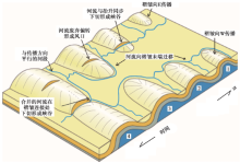
横向河要维持河道, 下切速率应与抬升速率近似相等(Whipple et al., 2002; Allen, 2008), 故当河流穿过抬升区时将会收窄河道的宽度以增加深度(Duvall et al., 2004), 进一步提高其侵蚀和搬运能力(Amos et al., 2007)。 因此, 河流在通过构造抬升区域时通常发育河道较窄的顺直河(Harbor, 1998; Whittaker, 2007)。 当河流通过自身调整无法适应变形区域的抬升速率时, 其河道必然发生偏转。 Humphrey等(2000)认为穿过褶皱区域的均衡河流将会在抬升区下游边缘形成裂点并以溯源侵蚀的形式传播, 在裂点到达抬升块体上游边界之前, 河流将会在上游沉积盆地内发生加积作用(图2a), 在此过程中盆地内的河流易于重组并最终导致河道发生偏转, 因此褶皱的抬升速率决定了河流的加积速率与时间, 进而决定了河流重组过程。 Collignon等(2016)利用SPM(Surface Processes Model)测试了横向河穿过褶皱时抬升速率对风口保存的影响, 结果表明: 抬升速率为0.4mm/a时, 大多河流可以穿过褶皱, 未见风口形成; 抬升速率为1mm/a时, 部分河流发生偏转、 汇聚, 风口开始形成; 抬升速率为2mm/a时, 河网完全偏离了生长褶皱并选择从褶皱两端穿过, 其间形成大量风口。 上述研究共同指示了抬升速率越高, 河流的偏转与重组越显著、 风口数量越多。
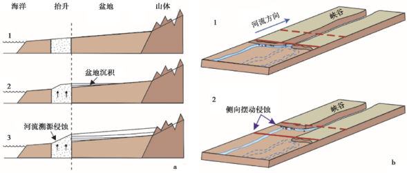 | 图 2 河流对抬升基岩的侵蚀 a 抬升区域下游的河道向上游溯源侵蚀, 上游以加积为主, 据Humphrey等(2000)修改; b 河流在上游以侧向摆动的方式侵蚀基岩, 需注意上、 下图中红色线条的位置是固定的, 据Cook等(2014)修改Fig. 2 Schematic diagram illustrating the incision of bedrock. |
除抬升速率的大小之外, 抬升速率的变化对风口的形成也具有重要影响, 包括地震活动引起的瞬时构造以及长尺度构造活动中存在的相对平静期和活跃期的变化(Jackson et al., 2002)。 地震发生时瞬间的抬升量远超河流的下切速率(Meghraoui et al., 1988), 如果地震间隔足够长, 河流有充分的时间调整其纵剖面, 其下切就可以与长时间尺度的抬升速率保持一致(Burbank et al., 1996)。 数值模拟表明, 均匀的地震周期并不影响横向河的演化(Champel et al., 2002)。 而对于更长的时间尺度(如几十万a), Collignon等(2016)通过数值模拟的方式展示在相同的总时间及总抬升量下, 处于恒定抬升速率(相对较小的速率)下的横向河仍旧能保持与褶皱抬升同步发育, 而在抬升速率与时间呈高斯式分布的情况下, 河道更容易被废弃而形成风口。 因此, 相对于抬升速率的绝对值, 构造过程的持续时间及其变化快慢对横向河的发育也至关重要(Collignon et al., 2016)。
上述研究结果共同表明, 在较高的抬升速率以及活动速率剧烈变化的条件下, 河道更容易被废弃形成风口。 此外, 地震所诱发的滑坡等地质灾害在高抬升速率区域十分常见(Hovius et al., 2000), 滑坡过程可有效增加河流沉积物负载并影响河流的水沙关系(本文第三节), 这一过程同样影响横向河的演化。
1.2.1 侧向扩展
若河流无法直接切穿褶皱, 则倾向于偏向褶皱末端(图3a)。 如果断层生长过程中仅在垂向累积位移而长度并不增加, 例如早期构造再活化形成的断层, 或由于断层顶点的相互作用造成长度生长延迟(Walsh et al., 2002; Ghisetti et al., 2007)等, 类似情况可简化为褶皱生长的翼旋转模式(图3d)。 由于褶皱末端已固定, 一旦河道废弃, 河流倾向于直接流向最末端而只形成1个风口(Keller et al., 1999)。 这种类型的风口可以用于指示非侧向传播褶皱的中心与两端抬升速率的差异(Amos et al., 2010)。
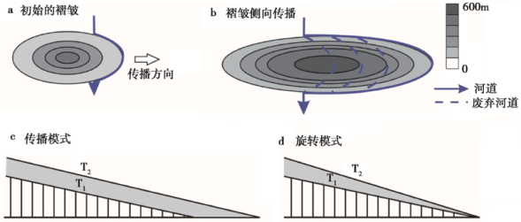 | 图 3 褶皱的生长与穿过褶皱的河流 a 河流在无法切穿褶皱时选择从边缘绕过; b 随着褶皱侧向传播, 河流逐渐废弃、 偏转, 并发育系列风口或水口; 当褶皱有足够宽度时, 风口在平面上可能表现为弯曲的形态(图中蓝色虚线); c 褶皱生长过程中高度和长度同时增加, 灰色区域代表高度增加的部分; d 褶皱生长过程中高度增加但长度不增加, 表现为翼的旋转。 a、 b据Bretis等 (2011)修改; c、 d据Keller等(1999)修改Fig. 3 Interactions of folds growth with rivers. |
更多情况下, 断层生长过程中通常具备较快的侧向传播的速率(Mueller et al., 1997; Jackson et al., 2002)。 与此同时, 褶皱的长度也会随之增加(Dawers et al., 1993), 此过程可简化为图3c。 随着褶皱的侧向扩展与抬升, 处于褶皱末端的河道会下切形成峡谷; 如果该过程中河流的下切速率小于抬升速率, 河流就会再次发生转向, 形成风口(Ramsey et al., 2008; Bretis et al., 2011)(图3b)。 该过程通常可以形成2个或以上的风口或水口(Keller et al., 1999), 风口底部高程的水平延伸(图1b中的黑色虚线)与原始地形面(图1b中的灰色虚线)相交的位置就是下一个风口或水口的位置(Hetzel et al., 2004)。 因此, 连续的风口通常作为断层侧向生长的证据(Jackson et al., 1996; Delcaillau et al., 1998)。 需要注意的是, 曾存在冰川侵蚀作用的区域并不适用上述规则。 新西兰Ostler断层区域存在1条活动断层, 其长度没有明显增加却同时存在多个风口、 水口, Amos等(2010)推测这些通道是LGM时期大规模冰川前进并侵蚀生长褶皱而残留下来的。
 | 图 4 2个褶皱生长传播过程中形成水口或风口的示意图(据Ramsey et al., 2008修改)Fig. 4 A cartoon showing the formation of wind/water gaps between two propagating anticlines through time(adapted after Ramsey et al., 2008). |
褶皱的隆升幅度在轴向上并不一致, 这种差异化运动通常会引发一种特殊的变形方式--捩断层(tear fault)(Mueller et al., 1997)。 美国加利福尼亚州Wheeler Ridge的侧向传播伴随着捩断层的发育, 且地震反射数据显示主要的风口或水口的位置与捩断层一致, 据此可认为捩断层对风口或水口的发育有重要影响(Medwedeff, 1992; Mueller et al., 1997)。 考虑到地貌过程同样可以诱发地质过程(Zeitler et al., 2001; Finnegan et al., 2008), 是捩断层的发育促进了河谷的下切, 还是河谷的下切促使捩断层发育, 目前依旧未知。 为了更好地理解两者之间的关系, Seong等(2011)测试了青藏高原东北缘榆木山风口处捩断层错断沉积物的年代, 并与推测的风口废弃年代进行对比。 结果显示, 捩断层发育的时代更年轻一些, 该结果支持河流侵蚀导致捩断层发育的观点。
1.2.2 断层连接
生长的褶皱可以侧向传播, 2个或以上的褶皱可以相向传播连接形成更长的褶皱构造(Cartwright et al., 1995; Dawers et al., 1995)。 对于无法直接切穿褶皱的河流, 褶皱的相向传播会迫使河流流向褶皱连接的部位。 图 4 展示了2个背斜相向生长条件下的河流行为: 1)首先, 2个小的褶皱分别在东侧和西侧形成; 2)随后, 2个褶皱相向传播, 西侧河流的下切速率与抬升一致, 切穿褶皱; 3)随着褶皱的持续生长, 西侧河流已不能穿过褶皱而发生偏转, 此时风口形成; 4)2个褶皱连接后, 汇聚后的河流在连接位置切穿抬升区, 形成峡谷。
断层连接导致的风口发育在野外工作和数值模拟中均已得到验证。 在喜马拉雅前陆褶皱Janauri背斜中段, Malik等(2007)发现了一个保存了晚第四纪河流砾石层的平坦地形面, 砾石组构分析表明这些沉积是大型河流Sutlej流经时留下来的。 综合的构造、 地貌证据认为Janauri背斜是2条断层连接形成的, 连接过程中河道废弃并形成了该风口(Malik et al., 2010)。 另外, 尼泊尔西部Dundwa Ridge断层的生长普遍存在联结现象, 区域内河网明显受褶皱生长的影响, 并发育大量风口(Gupta, 1997)。 为定量分析断层连接作用下横向河的演化过程, Champel等(2002)综合断层相关褶皱和地貌演化模型(CASCADE)(Braun et al., 1997), 建立了2条相距40km并在不同时间成核的断层, 2条断层按照一定速率相向传播并在75ka后发生连接。 结果显示, 由于褶皱的相向传播, 河流选择向2个褶皱之间汇聚; 随着2条断层的进一步连接, 汇聚而成的横向河谷最终废弃并形成风口; 而2个褶皱相交区域的后缘则发育为1个汇水盆地。 这样的模式与Dundwa Ridge野外观察的结果非常匹配。
上述情景都是单排褶皱影响下的横向河演化模式。 褶皱侧向传播可能并不与周边的褶皱连接, 而是形成雁行排列或者多排平行的褶皱(Dawers et al., 1995)。 多个褶皱的出现显然增加了横向河向下游贯通的难度。 Collignon等(2016)通过数值模拟的方式展示了多排褶皱条件下河流有更高的可能性不再连通(无法绕过褶皱而通往下游), 进而发育更深、 更大的褶皱后缘盆地并形成纵向河。 相对于横向河, 纵向河的长度更长、 比降更小, 这增加了沉积物在通往基准面途中被困在盆地的可能性(Tucker et al., 1996), 因此潜在地增强了河流对上游构造或气候信号的缓冲作用(Allen, 2008)。 褶皱活动通过影响横向河与纵向河的分布进而扰乱了沉积系统的形态, 该方面的研究对于预测沉积中心与油气开发的意义不言而喻。
综合上述研究, 褶皱的侧向扩展通常可导致多个风口或水口排列分布, 但一些特殊情形下多个风口或水口的发育可能与冰川活动或捩断层有关。 对于相向传播的褶皱, 河流无法直接切穿时倾向于汇集于两者相交的区域; 随着褶皱进一步连接, 合并的河流发生废弃, 褶皱后缘发育湖泊沉积。 雁行排列或者多排平行褶皱的发育将影响河网格局与盆地分布, 进而影响沉积系统的形态。
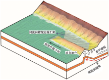
自然界中断层的滑脱面通常具有一定的角度, 该角度在一定程度上会影响褶皱后缘盆地的形态, 从而进一步影响横向河网的形态。 喜马拉雅山前很多区域有着相似的岩性、 下切和抬升速率(Lavé et al., 2000; Kirby et al., 2001), 却发育着截然不同的河流类型。Peter等(2002)利用CASCADE模型系统地模拟了断层滑脱面的角度对横向河演化过程的影响。 结果显示, 增加滑脱面角度后, 河流在到达褶皱前就开始转向, 并在褶皱后缘形成纵向干流, 未发育风口或水口(图 5)。 随着断层的传播, 具有一定角度的滑脱面导致褶皱后缘盆地也同时发生抬升, 且抬升幅度从中间向两侧降低。 上述过程使得河网转向更加有效, 因此Peter等(2002)认为下伏滑脱面的倾角是控制河网发育的第一要素, 尼泊尔东、 西部流域类型的显著不同可能受控于俯冲的印度板块的倾角。 按照上述模型, 盆地面的倾向是滑动速率、 传播速率以及滑脱面倾角的函数。 因此, 理论上河流的偏转方向(近似盆地面的倾向)可以约束上述断层相关褶皱的一些参数, 如已知滑脱面倾角和垂直抬升速率可预测其横向传播速率等。 该方法对于发育单个断层的小流域来说是可靠的, 但对于发育多条断层(如涉及断层连接等情形)的大型流域并不适用。
褶皱的宽度(或波长)也是褶皱生长过程中的1个变化参数。 对于滑脱褶皱, 褶皱的宽度取决于褶皱层的厚度、 岩石介质、 流变性质等多种因素(Price et al., 1990), 这里仅考虑断层的几何形态对褶皱宽度的影响。 对于断弯褶皱, 滑脱面向上转折点的深度控制着褶皱的宽度。 加入了滑脱面的地貌演化模型的模拟结果表明, 褶皱的宽度越大(对应滑脱面向上转折点越深)则河流越难以穿过褶皱(Champel et al., 2002)。
 | 图 5 滑脱面具有高倾角时横向河网的偏转 随着断层的侧向传播, 侧向的位移梯度导致褶皱后缘盆地发生倾斜, 据Champel等(2002)修改Fig. 5 Cartoon showing the deflection of rivers above a dipping detachment. |
河流携带适量的沉积物可使其侵蚀能力最大化, 过量的沉积物则限制河流的侵蚀能力(Sklar et al., 2001; Whipple et al., 2002)。 气候与基岩抗蚀性的变化可改变沉积物通量与流量之间的比例, 从而影响河流的搬运和侵蚀能力(Wickert et al., 2013), 进而影响横向河网的演化和风口的形成。 同时, 河流系统自身演化过程中发生的袭夺也会导致河道废弃(Bishop, 1995)。 下文将从气候、 基岩的抗蚀性与袭夺3个方面探讨河流过程对横向河网演化与风口形成的影响。
如果简单地认为湿润时期河流可以穿过生长褶皱、 干旱时期河流无法维持下切而只能偏转到褶皱边缘通过, 那么在晚第四纪100ka的气候变化周期下, 断层生长和周期性变化的气候之间相互作用就会形成系列的、 均匀间隔的峡谷。 事实上, 对于新西兰的South Rough Ridge, 其水平传播速率约为1.8mm/a, 意味着经过100ka断层仅横向传播约180m, 与风口或水口间距达6~10km的现状差异显著, 因此气候的周期性变化不足以解释横向河网中风口或水口的分布情况(Jackson et al., 2002)。 利用CASCADE重现的该区域水系格局的数值模拟结果也表明, 变化的气候条件(和幕式抬升)对于形成这种间隔分布的风口或水口格局并非必要条件(Tomkin et al., 1999)。
另一种观点则认为变化的气候对风口的形成有重要影响。 美国Wheeler Ridge之上的风口被废弃的年代为60kaiBP, 同期发生了显著的加积事件, Keller等(1998)将其解释为气候变化导致河流的侵蚀能力降低, 最终导致河流废弃并发育为风口。 Hampel等(2016)结合三维力学构造模型(ABAQUS)(Hampel et al., 2009)和CASCADE(Braun et al., 1997)模拟发现: 对于持续稳定的降水, 风口的形成通常集中在褶皱发育的早期(抬升初期大量河流被废弃)或晚期(持续的隆升导致原有河流在晚期全部被废弃); 而如果降水发生变化, 风口通常在转换到干旱环境后100~200ka形成。 对于气候变化条件下的风口, Hampel等(2016)认为是干旱期降水的减少使得褶皱上游河道沉积物发生堆积, 进而降低了河流侵蚀褶皱的能力, 河流的下切无法与抬升量同步导致风口形成。 相对于稳定的气候条件, 这种模式下形成的风口的高程和年代有着更广泛的范围。 Hampel等(2016)进一步将模拟结果与青藏高原东北缘河西走廊地区的风口序列进行对比, 认为中亚地区上新世-第四纪干旱化在该区域风口的形成中扮演重要角色。
基岩抗蚀性对河流行为的影响主要体现在2个方面, 即抬升区域基岩的抗侵蚀能力和抬升区域上游基岩的抗侵蚀能力。 抬升区域的岩石抗蚀性差(如厚层的冲洪积物、 弱胶结地层), 河流更容易切穿褶皱。 而随着褶皱的生长, 成岩程度更高的核部岩石逐渐出露, 河流动能无法平衡抗蚀性更强的岩层, 则会导致河道废弃形成风口(Burbank et al., 1999)。
抬升区域上游岩石的抗侵蚀能力还可以通过影响河流系统的水沙关系进一步影响横向河的演化。 在抬升区的上游, 如果河流流经松散基质, 必然快速装载沉积物, 这将在一定程度上降低其侵蚀能力; 另一方面, 过量的沉积物会导致河道加积、 降低河流的比降并进一步降低侵蚀能力。 仿真实验表明, 这种情形下河流无法有效侵蚀抬升区域而只能发生偏转, 与其它河道合并后再穿过抬升区或注入小型盆地(Douglass et al., 2007; Kim et al., 2010)。
上述河网重组的主要方式是河流偏转、 合并, 随着河流系统自身的发展, 袭夺过程在横向河流域演化、 风口的形成上也有着重要地位。 仍以美国典型的Wheeler Ridge为例, 其风口的形成被认为是褶皱边缘的1个支流袭夺了原先穿过褶皱的河流的上游, 导致被袭夺河流的流域面积减小而无法穿过褶皱(Keller et al., 1999)。 对于同时存在纵向河与横向河的区域, 如摩洛哥Altas山脉, 具有较强侵蚀能力的横向河向上游溯源侵蚀并不断蚕食纵向河的流域面积, 也可导致纵向河部分河段被废弃形成风口(Babault et al., 2012)。 该种类型的风口通常位于横向河与纵向河之间的分水岭之上, 并作为纵向河向横向河转化的证据(Babault et al., 2012)。 最近的一项仿真实验重现了上述过程, 即在持续缩短条件下的褶皱山系, 其流域格局将通过袭夺由纵向河主导逐步转变为横向河主导(Viaplana-Muzas et al., 2018)。 与前文中年轻的褶皱限制河流的流向导致褶皱后缘发育纵向河(图 4)不同的是, Altas山脉处于区域坡度不断增大导致横向河不断袭夺纵向河的阶段。
综合上述研究, 风口的形成与气候事件是否有对应关系仍存在分歧, 但不可否认的是气候与岩性共同控制的水沙关系对河网的重组过程至关重要。 另外, 袭夺形成的风口主要有2种类型: 一种发育于被袭夺河的下游, 其由于流域面积急剧减小而形成风口; 另外一种发育于袭夺获取河段与被袭夺河残留段之间, 以分水岭的形式存在。
前文分别分析了构造过程和河流过程对横向河演化与风口形成的影响, 而自然界中的相关过程通常为多要素共同作用的结果(Bufe et al., 2016; Collignon et al., 2016)。 鉴于活动褶皱区域构造变形的多样性, 地表侵蚀、 堆积过程的复杂性, 野外工作中通常难以限定各个要素所贡献的比例。 因此, 数值模拟和仿真实验被用于分析多要素的共同作用, 其结果可较好地解释所观测到的野外现象。
塔里木盆地西北缘的天山前陆地区是横向河网发育的典型区域。 与前文中河流能否穿过褶皱的案例不同, 该区域存在的问题是褶皱能否被保存(Scharer et al., 2006)。 如果横向河以辫流或曲流的形式穿过抬升区, 河流将通过侧向摆动侵蚀隆起区(图2b)(Cook et al., 2014; Johnson et al., 2015), 甚至可将整个抬升区域夷平(Scharer et al., 2006); 如果发育顺直河道, 其能量将更多地作用于垂直下切, 褶皱被侵蚀的比例将较低。 理论上, 褶皱被侵蚀的比例(Fb)与单位时间再次搬运的沉积物体积和抬升体积这两者的比值(Qf/Qu)呈正相关(Bufe et al., 2016)。 再次搬运的沉积物体积取决于河流横向迁移的速率, 后者由河流的水沙比决定(Wickert et al., 2013; Constantine, 2014)。 因此, 以何种河型穿过抬升区, 其本质上受控于水沙比与抬升速率之间的关系。 Bufe等(2016)的水槽实验表明: 在水沙比一定的条件下, 抬升速率为0.14cm/h时整个抬升区域几乎被完全夷平, 河网表现为辫状; 而当抬升速率升至14cm/h时, 抬升区域仅出现条带状的峡谷, 河流顺直通过, 侧向侵蚀不明显。 另外, 在抬升速率一定的条件下, 含沙量的增加也会导致褶皱被侵蚀的比例增加。 这项研究通过多组实验确立了侵蚀比例与水沙比、 抬升速率之间具体的函数关系, 并将其用于评估天山前陆差异地貌的成因。
伊朗Zagros褶皱逆冲带内存在大量干涸的湖盆, 它们之间曾通过风口互连(Lee, 2015)。 Walker等(2011)认为, 随着整个区域在2~3MaiBP以来的加速隆升, 大量的横向河被废弃, 并演化为由纵向河主导。 Collignon等(2016)则认为, 如果加速隆升导致横向河网被废弃, 抬升速率更高的地区应该同样发育大量纵向河, 而事实上近海岸的高抬升区依然以横向河为主导。 因此, 单一因素不能完全解释野外现象。 另外, Collignon等(2016)发现, 纵向河通常发育在容易被侵蚀的岩性区域, 而横向河则发育于抗侵蚀能力强的区域。 因此, 岩性在空间上的差异可能同样影响该区域河网格局。 Collignon等(2016)使用SPM(Surface Processes Model)建立了岩性存在差异的双层结构模型, 并进一步将模型预测结果与伊朗西南Zagros褶皱带的流域格局与岩性、 抬升速率分布进行了对比, 发现野外现象与模拟结果具有很好的一致性, 并据此认为沉积物岩性与抬升速率共同控制该区域河网演化。 这些结果对预测褶皱逆冲带沉积中心、 指导油气开发等具有重要的理论意义。
通过前文所述可以发现, 褶皱区域横向河的演化与风口形成的研究主要集中于以下区域: 美国加利福尼亚Wheeler Ridge(Mueller et al., 1997; Keller et al., 1999)、 新西兰中部Otago地区(Jackson et al., 1996, 2002; Amos et al., 2010)、 吉尔吉斯斯坦境内的天山地区(Burbank et al., 1999)、 印度西北部Siwalik山前(Champel et al., 2002; Delcaillau et al., 2006)和伊朗的Zagros褶皱逆冲带(Bretis et al., 2011; Walker et al., 2011)等。 晚新生代以来印度与欧亚板块的碰撞不但造就了广阔的高原地貌, 同时其周缘发育了大量河流与年轻的山地。 这些区域, 如祁连山、 天山和龙门山等, 是研究地貌的形成、 构造与侵蚀相互作用的天然实验场所。 目前, 以这些区域为研究区, 在山体隆升时代、 河流下切速率等不同研究方向已进行了大量工作, 但尚未展开系统的数值或仿真模拟工作。 在高原周缘山地开展横向河演化与风口形成的研究, 对相关理论成果进行检验与应用, 是对青藏高原抬升扩展研究的有益补充, 同时对中国地貌学研究的深化具有重要意义。
合黎山-金塔南山位于青藏高原东北缘的河西走廊以北, 被认为是高原扩展的最北缘, 是高原正在形成的、 最新的组成部分(Hetzel, 2013; Zheng et al., 2013a, b)。 黄土高原孢粉记录(Wu et al., 2007)和柴达木盆地中2个钻孔的证据表明(Cai et al., 2012; Wang et al., 2012), 周边区域的气候自上新世以来逐步干旱, 并在多个时间节点上干旱加剧。 活跃的构造条件加上持续变干的气候为横向河的废弃和风口的形成提供了有利条件, 是研究横向河演化规律的理想区域。 黑河是研究区内最大的一条河流, 发源于祁连山, 自莺落峡出山后流向为N向, 遇龙首山转为NW向, 经正义峡穿过合黎山-金塔南山, 最终流向额济纳盆地(图6b)。 下文将主要讨论黑河在合黎山-金塔南山隆起作用下的演化过程。
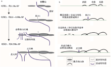
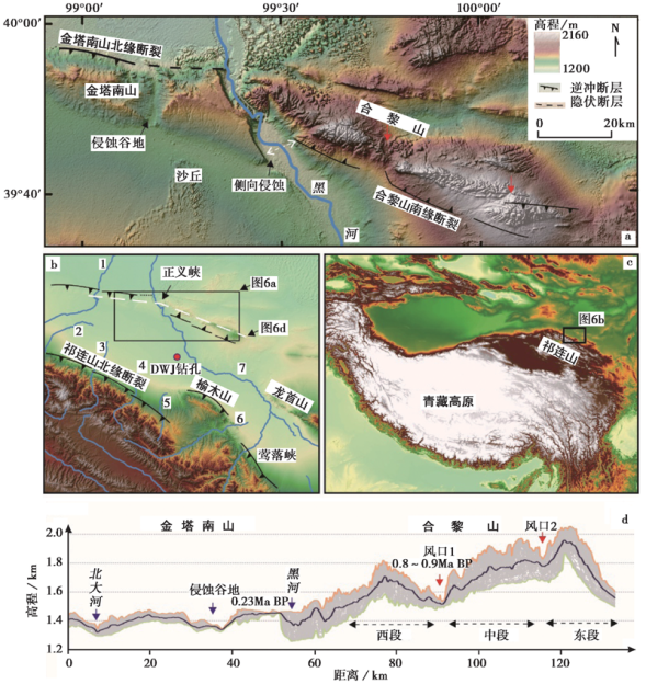 | 图 6 青藏高原东北缘合黎山-金塔南山的地貌特征 a 合黎山-金塔南山数字高程影像(DEM), 所处位置见图6b。 红色箭头指示合黎山上2个主要的风口, 黑色箭头指示金塔南山顶面局地河流溯源侵蚀形成的谷地以及黑河在金塔南山背翼通过侧向侵蚀切割隆起区域, 断层位置与性质见参考文献(何文贵等, 2012; Zheng et al., 2013b; 温振玲等, 2015)。 b 黑河中游DEM, 所处位置见图6c。 图中河流分别为: 1 北大河; 2 洪水坝河; 3 丰乐河; 4 马营河; 5 摆浪河; 6 梨园河; 7 黑河。 c 研究区位置图。 d 金塔南山-合黎山的高程断面, 宽5km, 所处位置见图6b中的白色虚线; 金塔南山的年代源自文献(Hetzel et al., 2004); 风口的年代由局地基准面之上的高程与垂直抬升速率(Zheng et al., 2013b)计算获得; 以风口1、 2为界, 合黎山可分为东、 中、 西3段Fig. 6 Topographic features of the Heli Shan-Jintanan Shan, northeastern margin of Tibet. |
合黎山整体表现为不对称的弧形, 山脊之上存在2个谷地, 被认为是黑河废弃后形成的风口(Hetzel et al., 2004; Zheng et al., 2013b)。 再加上现代黑河切穿的正义峡, 合黎山-金塔南山表现为多个风口或水口排列的形式(图6a, e)。 以上述风口为界, 合黎山可分为东、 中、 西3段并分别由3条断层控制(Zheng et al., 2013b)(图6a), 各段的断层活动速率表现出中间高、 两端低的特征(Zheng et al., 2013b)。 因此, 合黎山的隆起可能是多条断裂共同生长的结果(参考1.2节中对断层的侧向扩展与连接的论述)。 金塔南山位于黑河西侧, 控制其抬升的是一条S倾的逆冲断裂--金塔南山北缘断裂(图6a)(何文贵等, 2012; 温振玲等, 2015)。 当前黑河下切形成的正义峡正处于金塔南山北缘断裂与合黎山南缘断裂的转换区域, 而合黎山上发育的2个风口正处于合黎山南缘断裂东、 中、 西3段互相连接的位置(图6e)。 因此, 本研究区横向河的演化可能与这些年轻山体的生长密切相关。
利用2个风口在局地基准面上的高程(550m和280m)和抬升速率(Zheng et al., 2013b), 粗略估算得到合黎山上2个风口形成的时代分别是1.6~5.5MaiBP、 0.8~0.9MaiBP。 河西走廊内部的DWJ钻孔(图6b)沉积研究表明(Pan et al., 2016), 1.7MaiBP前走廊盆地内(酒东盆地)为湖相沉积, 1.1MaiBP以来黑河才开始发育, 因此风口2的形成与现代黑河无关。 另外, 野外考察也未发现黑河曾流经于此的证据, 因此我们推断该处的下凹地形可能是由断层相向生长所致。 钻孔沉积还揭示了现代黑河自形成以来其沉积具有多期旋回的特征, 并与区域气候有较好的对应性(Pan et al., 2016)。 风口1的形成(0.8~0.9MaiBP)恰好对应其中1期旋回开始的时间(约0.82MaiBP), 随后沉积物向上变细。 综合上述背景, 我们推测风口1的形成是构造活动与气候变化共同作用的结果。
风口1废弃之后, 黑河偏向西侧的金塔南山区域。 金塔南山的顶面保存有6~8m厚的磨圆分选均较好的河流砾石层, 组构分析表明这些砾石是由黑河及其支流, 如洪水坝河、 马营河、 丰乐河和北大河等从南部的祁连山携带而来(图6b)(温振玲等, 2016)。 Hetzel等(2004)利用宇生核素暴露测年得到砾石层的废弃年代为0.23MaiBP, 并认为金塔南山隆升始于此时。 而这套河流砾石层与下伏白垩系呈角度不整合接触(温振玲等, 2015), 指示褶皱开始活动的时代要早于砾石堆积的时代。 上述研究结果意味着风口1废弃之后至0.23MaiBP, 黑河及其支流在正义峡与鸳鸯峡之间的金塔南山区域摆荡(卢耀洋, 2014)并将一定幅度的抬升夷平(对应于与下伏地层的角度不整合)。 前文已述及, 完全夷平需要较高的河道迁移速率以及较低的抬升速率, 当抬升速率增大或河道迁移速率降低时, 山体会逐渐浮现, 河流将被限制在条带状的峡谷中。 因此, 正义峡的下切应对应抬升速率的增加或河道迁移速率的降低。 水槽实验揭示, 当抬升速率发生量级的变化时才能导致地形由完全夷平到狭窄峡谷的转变(Bufe et al., 2016)。 目前暂无金塔南山抬升速率变化的研究报道, 而最近对研究区南部祁连山北缘断裂的研究显示, 百万年以来地壳的缩短速率保持稳定(Hetzel et al., 2019)。 假设金塔南山地区的变形速率同样未发生显著变化, 我们推测正义峡的形成是河流夷平能力减弱导致的。 对于夷平能力的减弱, 一个最直观的证据是大量支流现已无法直接到达金塔南山区域(图6b), 其对抬升区域的夷平作用自然消失。 因此, 本文认为河流水动力的减弱是金塔南山出现正地形的关键要素, 而诱发该过程的原因是构造过程(如下伏滑脱面的生长、 褶皱宽度增加等, 参考本文第一节)还是河流过程(如降水减少)尚不得而知。 此外, 现今黑河与北大河仍通过侧向迁移侵蚀褶皱的背翼(图6a), 其河道迁移能力是否降低, 与褶皱的生长、 水动力变化又有何关系, 仍需进一步的工作。
综合上述分析, 黑河穿过合黎山-金塔南山区域经历了偏转-夷平-下切的过程(图 7)。 首先, 约1.1MaiBP时, 黑河从合黎山中段和西段之间(风口1)的位置通过。 0.8~0.9MaiBP, 合黎山中段和西段2条断层的进一步连接促使黑河发生偏转流向西侧的金塔南山区域, 水动力条件约于0.82MaiBP的变化可能对本次偏转具有一定的影响。 约0.23MaiBP开始, 来自于祁连山的河流夷平能力降低, 黑河选择合黎山-金塔南山连接的区域下切, 金塔南山开始出现正地形。
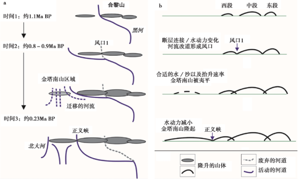 | 图 7 合黎山-金塔南山横向河演化与风口发育示意图 a 平面图; b 对应的抬升横截面图。 1.1MaiBP黑河从合黎山中段和西段之间的位置通过; 0.8~0.9MaiBP, 黑河流向西侧的金塔南山区域, 风口1形成; 一直到0.23MaiBP, 黑河及其支流在金塔南山区域摆荡并将抬升夷平; 自0.23MaiBP开始, 黑河选择合黎山-金塔南山连接的区域下切, 金塔南山开始出现正地形Fig. 7 The evolution of transverse drainages and development of water and wind gaps across the Heli Shan-Jintanan Shan. |
褶皱既可以响应下伏断层的垂直和侧向生长, 也可以与另外的褶皱连接、 排列形成更复杂的构造, 甚至可以直接改变褶皱后缘盆地的形态。 变化的气候条件会导致沉积物的供给和河流功率的变化, 并直接影响河流的下切能力。 由于坡面与河流对外界条件的变化存在响应时间, 周期性的气候和构造速率的变化对河流的下切和堆积过程也有重要影响。 河流侵蚀褶皱区域通常导致抗蚀性更强的岩石出露, 原有的河流动能可能无法维持下切; 褶皱后缘松散的沉积物也可能导致河流负载过大而提前发生偏转、 合并。 随着偏转的发展, 大量河流通过合并而增加流域面积, 并试图再次穿过褶皱形成横向河; 或流向未抬升的褶皱边缘, 随着持续的抬升形成水口。 上述演化过程中, 河流侵蚀如果无法抵消垂向抬升, 则河道被废弃形成风口。 横向河网的演化和风口的形成本质上在于构造与侵蚀、 堆积之间的相互关系, 野外工作通常难以将每个要素量化。 因此, 借助于仿真实验和数值模拟, 探索构造、 气候等各个参数之间的相互作用, 可为研究活动褶皱区域横向河网的演化提供更加开阔的视野和定量化分析。
青藏高原周缘发育大量河流与年轻的山地, 是研究地貌的形成、 构造与侵蚀相互作用的天然实验场所, 目前尚未对其展开系统的数值、 仿真模拟工作。 在高原周缘山地开展横向河演化与风口形成的研究, 不仅可以推动青藏高原抬升扩展研究, 而且可以促进中国地貌学的发展。 通过对已有研究认识的总结, 本文初步推断了河西走廊中段横向河演化的一般模式, 即偏转-均夷-下切(图 7)。 现代黑河约1.1MaiBP穿过合黎山, 而随着合黎山的生长、 黑河水动力条件的变化, 黑河偏转到达金塔南山区域。 由于合适的水沙比与抬升速率, 金塔南山区域早期抬升时处于夷平状态。 约0.23MaiBP以来, 大部分支流无法到达金塔南山区域, 黑河在金塔南山与合黎山连接的区域下切, 形成正义峡。
致谢 审稿专家对本文提出了宝贵的修改建议, 在此表示衷心感谢!
| [1] |
|
| [2] |
|
| [3] |
|
| [4] |
|
| [5] |
|
| [6] |
|
| [7] |
|
| [8] |
|
| [9] |
|
| [10] |
|
| [11] |
|
| [12] |
|
| [13] |
|
| [14] |
|
| [15] |
|
| [16] |
|
| [17] |
|
| [18] |
|
| [19] |
|
| [20] |
|
| [21] |
|
| [22] |
|
| [23] |
|
| [24] |
|
| [25] |
|
| [26] |
|
| [27] |
|
| [28] |
|
| [29] |
|
| [30] |
|
| [31] |
|
| [32] |
|
| [33] |
|
| [34] |
|
| [35] |
|
| [36] |
|
| [37] |
|
| [38] |
|
| [39] |
|
| [40] |
|
| [41] |
|
| [42] |
|
| [43] |
|
| [44] |
|
| [45] |
|
| [46] |
|
| [47] |
|
| [48] |
|
| [49] |
|
| [50] |
|
| [51] |
|
| [52] |
|
| [53] |
|
| [54] |
|
| [55] |
|
| [56] |
|
| [57] |
|
| [58] |
|
| [59] |
|
| [60] |
|
| [61] |
|
| [62] |
|
| [63] |
|
| [64] |
|
| [65] |
|
| [66] |
|
| [67] |
|
| [68] |
|
| [69] |
|
| [70] |
|
| [71] |
|
| [72] |
|
| [73] |
|
| [74] |
|
| [75] |
|
| [76] |
|