


青海达日断裂中段晚第四纪活动性与1947年 M73/4地震地表破裂带再研究
[梁明剑 , 杨耀
, 杨耀* , 杜方, 宫悦, 孙玮, 赵敏, 何强]
, 杨耀, 杜方, 宫悦, 孙玮, 赵敏, 何强]
|
|


作者简介:梁明剑, 男, 1979年生, 2019年于中国地震局地质研究所获构造地质学专业博士学位, 主要从事活动构造、 中长期地震预测方面的研究, 电话: 028-85447105, E-mail: 23800794@qq.com。
巴颜喀拉块体的边界断裂近20a发生了一系列大地震, 引起了国内外学者的关注。 然而, 在该块体内部还存在一些规模巨大的断裂带, 不仅具有晚第四纪活动性, 而且具有孕育和发生强震的构造条件。 达日断裂是巴颜喀拉块体内一条规模巨大的左旋走滑断裂, 曾发生过1947年达日 M7大地震。 文中基于高分辨率遥感影像解译和地震地质调查, 详细研究了达日断裂中段的晚第四纪新活动性和1947年达日大地震的地表破裂带。 达日断裂中段晚第四纪活动的行迹尤为显著, 1947年达日地震地表破裂带的SE端始于达日县莫坝乡隆根, 向NW延伸至建设乡依龙沟脑NW侧, 长约70km。 地震地表破裂带主要表现为地震坎、 地震鼓包与陷坑、 地震滑坡、 线性的碎裂基岩出露等地貌迹象, 并使一系列冲沟被同步左旋位错2~4m。
Bayan Hara Block is one of the most representative active blocks resulting from the lateral extrusion of Tibet Plateau since the Cenozoic. Its southern and northern boundary faults are characterized by typical strike-slip shear deformation. Its eastern boundary is blocked by the Yangze block and its horizontal movement is transformed into the vertical movement of the Longmen Shan tectonic belt, leading to the uplift of the Longmen Shan Mountains and forming a grand geomorphic barrier on the eastern margin of the Tibet Plateau. A series of large earthquakes occurred along the boundary faults of the Bayan Hara Block in the past twenty years, which have attracted attention of many scholars. At present, the related studies of active tectonics on Bayan Hara Block are mainly concentrated on the boundary faults, such as Yushu-Ganzi-Xianshuihe Fault, East Kunlun Fault and Longmen Shan Fault. However, there are also some large faults inside the block, which not only have late Quaternary activity, but also have tectonic conditions to produce strong earthquake. These faults divide the Bayan Hara Block into some secondary blocks, and may play important roles in the kinematics and dynamics mechanism of the Bayan Hara Block, or even the eastern margin of the Tibet Plateau. The Dari Fault is one of the left-lateral strike-slip faults in the Bayan Hara Block. The Dari Fault starts at the eastern pass of the Kunlun Mountains, extends eastward through the south of Yalazela, Yeniugou and Keshoutan, the fault strike turns to NNE direction at Angcanggou, then turns to NE direction again at Moba town, Qinghai Province, and the fault ends near Nanmuda town, Sichuan Province, with a total length of more than 500km. The fault has been considered to be a late Quaternary active fault and the 1947 M73/4 Dari earthquake was produced by its middle segment. But studies on the late Quaternary activity of the Dari Fault are still weak. The previous research mainly focused on the investigation of the surface rupture and damages of the 1947 M73/4 Dari earthquake. However, there were different opinions about the scale of the M73/4 earthquake surface rupture zone.
近20a以来, 巴颜喀拉块体周缘发生了一系列大地震, 块体边界断裂的活动性与强震危险性引起了广泛关注(徐锡伟等, 2008; 邓起东等, 2010; 闻学泽等, 2011)。 然而, 巴颜喀拉块体内部还存在一些规模巨大的断裂带, 不仅具有晚第四纪活动性, 而且具有孕育和发生强震的构造条件。 达日断裂位于巴颜喀拉山北麓, 为一条晚第四纪活动的左旋走滑断裂(戴华光, 1983; 青海省地震局, 1984; 梁明剑等, 2014)。 断裂西起昆仑山东口, 向E经雅拉泽拉南坡、 野牛沟、 克授滩, 于昂苍沟口转为NNW向, 至青海省达日县莫坝乡一带又转为NW向, 一直延伸至四川省南木达一带, 全长> 500km, 总体走向 N60° W。
1947年3月17日达日断裂中段曾发生过一次大地震, 微观震中位置为(33.3° N, 99.5° E), 震级为M73/4(戴华光, 1983; 中国地震局震害防御司, 1999)。 该地震发生在巴颜喀拉块体内部, 震中区位于巴颜喀拉山北缘, 震中烈度达到Ⅹ 度, 等震线的长轴方向为 N40° ~50° W(戴华光, 1983; 青海省地震局, 1984)。 然而, 关于达日断裂晚第四纪活动性方面的研究仍比较薄弱(张裕明等, 1996; Yan et al., 2013; 梁明剑等, 2014), 早期的研究主要是针对1947年达日地震的地表破裂带和破坏程度的考察(戴华光, 1983; 青海省地震局, 1984; 叶世强等, 1993), 而最近的研究则偏向达日断裂及其周边地区的宏观构造地貌(Yan et al., 2013; 梁明剑等, 2014; 李辉, 2016; 游建飞等, 2016)。 此外, 目前关于1947年达日地震的地表破裂带规模也存在分歧。 戴华光(1983)认为该地震的地表破裂带长达150km, SE端始于达日县莫坝乡吉迈, 向NW经昂仓、 苏士贡玛至玛多县克授滩。 青海省地震局(1984)则认为达日地震地表破裂带的SE端自达日金渡南日查东侧开始, 向NW经江基贡玛沟脑、 昂苍、 依龙沟脑, 全长仅58km。 本文基于高分辨率遥感影像解译和地震地质调查结果, 对达日断裂中段晚第四纪活动的行迹特征进行调查, 并对1947年达日地震的地表破裂带开展再研究工作, 为深入研究达日断裂的晚第四纪活动习性奠定基础。
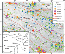
研究区位于巴颜喀拉块体内部, 区内广泛出露三叠系复理石建造, 地层受区域构造运动控制, 自西向东岩层走向从NWW向逐渐转变为NW向, 与区域构造线方向大体一致(青海省地震局, 1984; 张以茀, 1996)。 此外, 山顶面零星残留着古近-新近系红色砂砾岩, 构成现今的夷平面; 第四系主要分布在河谷和冲沟等低洼地带。 达日断裂晚第四纪活动表现出明显的分段性。 断裂NW段(克授滩-苏土贡玛段)主要控制中生代地层的分布, NNW向的山梁明显将NW向的河谷分割, 从而组成了支流分水岭, 水系向两侧流出, NW向河谷呈现相对老化的地貌特点, 表明该段晚第四纪以来的活动性不显著(青海省地震局, 1984)。 断裂中南段(苏土贡玛-莫坝段)晚第四纪活动性明显, 在航、 卫片上反映清晰, 沿断裂形成一系列断层槽谷、 陡坎等地貌, 对断裂沿线古近-新近纪地层分布有明显控制作用。 此外, 中段的构造样式也比较复杂, 曾发生过1947年M73/4大地震(戴华光, 1983; 青海省地震局, 1984; 梁明剑等, 2014)。 达日断裂向SE延伸入四川省境内后, 断裂新活动形迹明显减弱。 达日断裂沿线的地震活动也呈现明显的差异性, 北段的弱震活动相对比较活跃, 曾经在1995年发生过M6.4和M6.2i2次中强震; 中段现今地震活动比较活跃, 除发生过1947年M73/4地震(戴华光, 1983; 中国地震局震害防御司, 1999)外, 还发生过1949年M6地震和1961年M5.2地震以及多次4级以上地震; 南段的地震活动较弱, 仅南端与松岗断裂、 龙日坝断裂交会处弱震活动频繁(图 1)。
早期针对达日断裂的研究主要集中于对1947年M73/4地震的宏观破坏、 地表破裂带和发震构造的考察(戴华光, 1983; 青海省地震局, 1984; 叶世强等, 1993)。 针对达日断裂晚第四纪新活动性方面的研究也十分薄弱, 仅张裕明等(1996)进行了比较初步的研究, 利用简单的探槽和热释光测年得到1947年达日地震之前一次的古地震年龄为(4.1± 0.3)ka, 获得的断裂活动速率为14.2mm/a。 近年来, 陆续有学者采用数字高程(DEM)数据和GIS技术对达日断裂周边地区的宏观构造地貌和晚第四纪新活动性进行初步调查(Yan et al., 2013; 李辉, 2016; 游建飞等, 2016); 梁明剑等(2014)基于达日断裂沿线流域盆地的面积-高程积分(HI值)探讨了地貌对活动构造的响应关系。 总而言之, 目前对达日断裂活动性的研究仍比较薄弱, 即使对于早期研究较多的1947年达日地震, 关于其地表破裂带的规模也存在不同的认识(戴华光, 1983; 青海省地震局, 1984; 叶世强等, 1993)。
 | 图 1 研究区域主要活动断裂及地震活动分布Fig. 1 The major active faults and seismicity in the research region. |
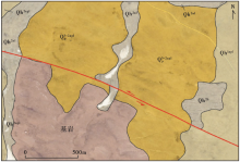
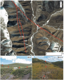
达日断裂中段晚第四纪新活动性明显, 在断裂沿线形成一系列断层槽谷、 陡坎等线性地貌, 且依然较好地保存了1947年地震的地表破裂带。 于达日断裂中段南端的莫坝乡隆根附近, 断裂切过山前冲洪积台地和吉迈曲的阶地, 在台地上形成槽谷地貌, 局部发育沼泽带(图 2)。 1947年达日地震的地表破裂带切过该处的Ⅱ 级冲洪积台地, 沿着台地上线性断层槽谷北侧反向陡坎的底部发育。 反向坎顶部转折部位受到破裂带的影响而撕裂, 形成线性撕裂带; 坎底部被破裂带切过, 形成一系列裂缝带, 两侧草皮受到其影响, 呈现出不一样的生长特征(图3a)。 破裂带向NW切过最新的冲洪积扇, 在断层西盘形成断塞塘或沼泽洼地(图3b); 而破裂带向SE的行迹不甚明显。
 | 图 2 莫坝乡隆根一带达日断裂的形迹Fig. 2 The track characteristics of the Dari Fault near Longgen village, Moba town. |
 | 图 3 达日地震破裂带南端的形迹特征 a Ⅱ 级冲洪积扇上的破裂带, 沿着北侧反向陡坎的底部发育; b 破裂带切过最新冲洪积扇, 形成断塞塘或沼泽洼地Fig. 3 The characteristics of the southern surface rupture zone of the Dari earthquake. |
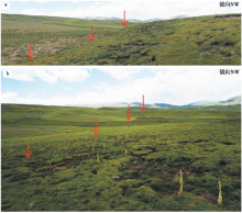
断裂向NW经果查玛、 日查南、 萨尔根, 切过低矮的圆丘或高台地, 宏观上形成断层槽谷地貌。 在果查玛附近一圆丘的北侧地震破裂带保存良好, 发育了2支地表破裂带--主破裂带F1和次级破裂带F2, 其中次级破裂带长约400m(图4a)。 沿破裂带还发育高1~2m的断层陡坎, 局部坎下可见泉水冒出(图4b)。 被破裂带撕裂或破坏的草皮基本愈合, 但破裂带沿线新生长的草地颜色明显与周围不同(图4b, c)。
 | 图 4 莫坝乡果查玛一带的地表破裂带 a 果查玛一圆丘北侧发育2支地表破裂带F1和F2; b 破裂带F1的形迹特征; c 果查玛圆丘北侧破裂带南端的形迹特征Fig. 4 The characteristics of the surface rupture zone near Guorima, Moba town. |
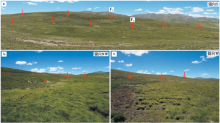
在萨尔根村南断裂切过山腰, 形成明显的线性陡坎和坡折形迹, 坎下发育沼泽带, 出露泉水(图5a)。 其中, 在观察点A处(图5a)见一段长约7~8m的地震破裂陡坎, 局部出露为基岩断层坎, 坎高约0.8~1.2m(图5b), 在陡坎南侧(观察点B)一冲沟堆积的倒石堆被同震左旋位错约2.5m(图5c)。
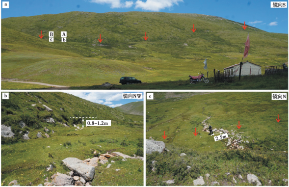 | 图 5 莫坝乡萨尔根村一带的地表破裂带 a 破裂带切过山腰, 形成线性的断层陡坎及坡折带; b 破裂陡坎, 坎高为0.8~1.2m; c 冲沟堆积的倒石堆被同震左旋位错约2.5mFig. 5 The characteristics of the surface rupture zone near Saergen, Moba town. |
至达日金渡南, 达日断裂切过江基贡玛南山前的洪积扇台地, 形成反向槽谷、 泉眼等构造地貌。 达日地震的地表破裂带一般沿着槽谷北侧延伸, 导致槽谷底部的草皮被撕裂, 并形成地震陡坎、 地震鼓包等(图 6)。 在江基贡玛支沟口南侧的洪积台地, 断裂沿线发育反向槽谷、 断塞塘等地貌, 地表破裂带沿着断塞塘北侧延伸, 在地表依稀可见尚未完全愈合的裂缝带(图7a)。 跨破裂带和断塞塘的探槽揭露, 断层除走滑运动外, 还兼具自NE向SW的逆冲性质。 断裂的最新活动导致标志性的灰白色砂层U被断错、 折弯变形(图7b)。
 | 图 6 江基贡玛一带的地表破裂带 a 破裂带切过槽谷, 导致草皮撕裂, 形成高约0.4~1.0m地震陡坎; b 破裂带切过槽谷北侧, 形成地震鼓包等Fig. 6 The characteristics of the surface rupture zone near the Jiangjigongma, Moba town. |
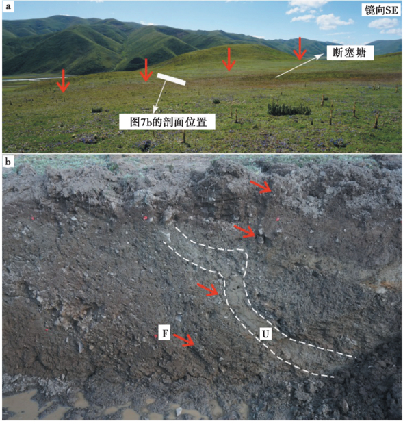 | 图 7 江基贡玛沟口洪积台地上的地表破裂带 a 地表破裂带与断塞塘地貌; b 探槽局部剖面, 标志地层U被断错、 折弯变形, F为断层Fig. 7 The characteristics of the surface rupture zone on the alluvial fan near Jiangjigongma. |
达日断裂延伸至昂苍沟, 沿山前呈NNW向延伸、 向SW突出的弧形, 断裂沿线发育一系列泉眼, 断裂的新活动导致一冲沟被左旋位错约9.5m, 并形成跌水地貌。 断裂向N继续延伸约2km(图8a, b)。 但1947年达日地震的地表破裂在NNW弧形断裂上并不明显, 仅在与主断裂交会处附近存在零星的可疑行迹。 达日地震的地表主破裂从昂苍沟东侧的山脊呈NW向切过昂苍沟, 地震破裂导致基岩被破坏, 形成线性的破碎基岩(图8c)及地震鼓包、 挤压脊等地貌。
 | 图 8 昂苍沟一带的达日断裂行迹及地表破裂带 a 达日断裂于昂苍沟口局部呈弧形展布; b 达日断裂将一冲沟左旋位错约9.5m, 并形成跌水地貌; c 昂苍沟口东山梁上的地表破裂带, 破裂带导致基岩劈理化, 并出露线性形迹Fig. 8 The characteristics of the fault track and the surface rupture zone near Angcang. |
在昂苍沟口以西, 达日地震的地表破裂带沿着昂苍沟NE侧山前一线延伸, 形成线性地震坎、 地震鼓包、 宽30~40m的草皮线性撕裂带和泉眼等地貌, 并导致一系列冲沟或新冲积扇侧缘被左旋位错(图 9)。 图9b显示破裂带沿着老断层陡坎的腰部发育, 形成新的地震陡坎, 高约0.5~1.5m; 图9c和9d显示最新冲洪积扇侧缘和一冲沟分别被同震左旋位错约4.1m和2.2m, 其中4.1m的位错受到冲沟壁垮塌的影响, 结果可能偏大。 达日地震的地表破裂带向NW延伸至依龙沟脑附近后形迹不甚明晰, 地貌上主要表现为沿破裂带发育一系列泉眼。 因此, 分析认为达日地震的地表破裂带延伸至依龙沟脑NW附近逐渐消失。
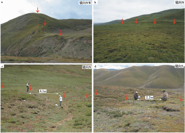 | 图 9 昂苍沟NW山前洪积扇上的地表破裂带 a 破裂带切过山脊, 形成线性凹槽; b 破裂带沿老陡坎的腰部发育, 形成新的线性迹线; c 新冲积扇侧缘被左旋位错约4.1m; d 冲沟被左旋位错约2.2mFig. 9 The characteristics of the surface rupture zone on the alluvial fans near the northwest of Angcang village. |
达日断裂为巴颜喀拉块体内部一条规模较大的左旋走滑断裂, 具有晚第四纪活动性和孕育、 发生大地震的构造条件。 其中, 断裂中段的新活动性尤为明显。 断裂沿线发育反向槽谷、 断层陡坎、 线性泉眼等地貌, 并左旋断错一系列的冲沟; 断裂在昂苍沟口东侧局部呈向SW突出的弧形, 而在昂沟口西侧, 断裂仍呈NW走向继续沿山前展布; 延伸至桑日麻盆地, 由于受到桑日麻盆地东、 西两侧近SN向断裂的制约, 达日断裂中段应终止于桑日麻盆地。
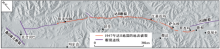
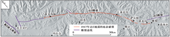 | 图 10 1947年达日地震的地表破裂带分布图Fig. 10 The distribution map of the surface ruptures zone of the 1947 Dari earthquake. |
由于受剥蚀作用和同震滑坡的影响, 达日地震中的一些次级破裂已经很难再考证; 且在不少区域同震滑坡也可能覆盖了主破裂带, 导致主破裂带不连续, 但往往在滑坡的前缘可能出现泉眼, 线性的泉眼分布也是辅助判断地表破裂带位置的地貌之一。 基于高分辨率遥感解译和地震地质调查分析认为, 1947年达日地震的地表破裂带自SE端始于达日县莫坝乡隆根, 向NW经过果查玛、 萨尔根、 江基贡玛和建设乡昂苍沟至依龙沟脑NW附近, 全长约70km(图 10)。 地震的主破裂带主要表现为地震陡坎、 地震鼓包与陷坑、 地震滑坡、 基岩劈理出露等地貌, 且一系列的冲沟被同步左旋位错2~4m。
综上所述, 达日断裂中段具有明显的晚第四纪活动性, 曾发生过1947年达日大地震; 该地震的地表破裂带主要表现为地震陡坎、 地震鼓包与陷坑、 草皮撕裂带、 线性的碎裂基岩出露等地貌, 全长约70km, 同震位错为2~4m。
| [1] |
|
| [2] |
|
| [3] |
|
| [4] |
|
| [5] |
|
| [6] |
|
| [7] |
|
| [8] |
|
| [9] |
|
| [10] |
|
| [11] |
|
| [12] |
|
| [13] |
|