

长岛地区小地震断层面参数拟合及应力场特征
[崔华伟1, 2)  , 郑建常
, 郑建常1)), * , 张正帅1) , 李冬梅1) , 柴光斌3) ]
, 郑建常, 张正帅|
|


〔作者简介〕 崔华伟, 男, 1990年生, 2017年于防灾科技学院获地球探测与信息技术专业硕士学位, 助理工程师, 主要从事震源机制解和构造应力场方面的研究, E-mail: cuihuawei19900920@163.com。
文中基于小地震重定位数据计算了2017年长岛2个震群的断层面参数, 并使用综合震源机制法求解了长岛地区应力场。 通过应力场及断层面参数求得断层面上的滑动角, 确定了南部与北部震群发震断层的左旋走滑性质, 分析了南部与北部2个震群的应力场特征及发震构造, 并得到以下初步结论: 南部与北部震群的断层参数、 应力场存在一定差异; 北部震群断层面的走向为287.18°、 倾角为84.09°, 推断发震断层是大竹岛-威海北断裂NWW向延伸的隐伏断层; 北部震群受左旋走滑性质的蓬莱-威海断裂带控制, 呈NEE-SWW向挤压及NNW-SSE向拉张的走滑应力机制; 南部震群断层面的走向为269.67°、 倾角为67.46°, 其应力场呈NE-SW向挤压, 为近SN向拉张的正断兼走滑的应力机制, 其可能在蓬莱-威海断裂带左旋走滑的控制下还受到SN向的拉张作用, 北部震群的持续活动诱发EW走向的次级断裂错动产生南部震群。
Using seismic observation data of Shandong seismic network, we relocated 2 927 earthquakes( ML≥0.2) recorded from Feb. 2017 to Apr. 2019 with double-difference algorithm in Changdao area. The fault plane parameters are calculated with 1 631 relocated earthquakes in the northern and southern earthquake swarms based on the simulated annealing and Gauss-Newtonian nonlinear inversion algorithms. There are two different earthquake swarms in both sides of 38°N. In order to distinguish the different earthquake swarms, we divide them into the northern earthquake swarm locating in the north of 38°N and starting from Feb. 2017, and the southern earthquake swarm locating in the south of 38°N and starting from Aug. 2017.
The stress field of Changdao area is inverted with 7 266 P wave polarities of 2 518 earthquakes in the swarms using the composite focal mechanism method. This method takes full advantage of all P wave polarities, thus avoiding the errors brought about by inverting focal mechanism with P wave polarities. The study region is divided into grids of 0.25°×0.25° before the stress field inversion for the northern and southern earthquake swarms. The rake on the fault plane of the northern and southern earthquake swarms is calculated using the stress field and fault plane parameters.
1 432 and 219 earthquakes are used to calculate the fault plane parameters for the northern and southern earthquake swarms, respectively. The result shows that the fault plane parameters are different between the northern and southern swarm. The strike, dip and rake of fault plane are 287.18°, 84.09° and -18.3° in the northern earthquake swarm, which is nearly the same with the previous results of shallow-depth acoustic reflection profiling. The fault plane parameters for the southern earthquake swarm are 269.67°, 67.46° and -3.6°. This result is similar to that of marine geophysical survey and the seismo-geological studies. The type of both fault planes is sinistral strike-slip according to the rake on the fault plane.
The stress field is inverted with a 50km radius smoothing in this paper. In general, the stress field calculated by this paper is basically identical with the previous results obtained by focal mechanism inversion and hydraulic fracturing in-situ stress measurement in Changdao area and is consistent with the stress field of the North China area. The stress field is controlled by pushing and subduction of the Pacific Plate from east to west. But there is a slight difference in the stress field between the northern and southern earthquake swarms. The compressive axis of stress field is rotated between the northern and the southern earthquake swarms. The stress field is in strike-slip regime in the northern earthquake swarm. The direction of P-axis is NEE-SWW, with a nearly horizontal plunge, and the direction of T-axis is NNW-SSE with a low plunge. In the southern earthquake swarm, the stress field is in a regime of normal faulting with a small amount of strike-slip component. The P axis is in NE-SW direction with plunges varying from 30° to 50°, and the T axis is the same as the northern swarm.
Based on the fault plane fitting, the seismogenic fault for the northern earthquake swarm is maybe the buried NW extension of the Dazhu Island-Weihaibei Fault, and the southern earthquake swarm occurred on a secondary EW-trending fault. According to the rakes of seismogenic faults, both of them are of strike-slip movement, and the stress field is in strike-slip regime in the northern earthquake swarm and normal with a small amount of strike-slip in the southern swarm. Both northern and southern earthquake swarms are controlled by the sinistral strike-slip Penglai-Weihaibei Fault, but the southern swarm is also under the influence of SN extension. We believe that the reason for the different fault plane parameters and stress fields is the different structure of the northern and southern earthquake swarms.
基于地震参数拟合地震断层面一直是众多学者研究的热点问题之一(万永革等, 2008; Hayes et al., 2009; 王福昌等, 2013; 盛书中等, 2014; 谢张迪等, 2019)。 万永革等(2008)基于唐山地震和滦县地震断层面附近的小地震资料求解了断层面的走向和倾角及其误差范围, 根据小地震在断层面周围的分布确定了地震断层面的位置。 Hayes等(2009)使用震源参数通过最大似然估计给出了2005年苏门答腊南部地震和2007年智利北部海沟的安托法加斯塔地震破裂的断层面。 王福昌等(2013)利用地震空间分布的丛集性证实了1992年6月28日Landers地震的发震断层参数与已知地质破裂或隐伏断层相当吻合。 盛书中等(2014)利用2010年玉树MS7.1地震的余震分布给出了发震断层的断层面参数。 谢张迪等(2019)使用万永革等(2008)的方法得到了2014年云南景谷MS6.6地震的发震断层参数, 确定了地震发生的具体断裂及断裂性质。
鉴于前人在地震参数拟合断层面方面的工作, 本文以2017年2月14日的长岛震群为研究目标, 拟求取长岛震群的发震断层面参数, 该研究对探讨长岛震群的发震背景具有参考意义。
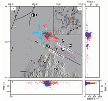
长岛地区(图1a)位于张家口-渤海断裂带和郯庐断裂带交会的东南部海域(图1b)。 张家口-渤海断裂带经过胶东半岛, 其东南段——蓬莱-威海断裂横穿研究区域(于磊, 2017; 陈阜超等, 2020; 顾勤平等, 2020; 郑颖平等, 2020)。 蓬莱-威海断裂带是由多条近NW-SE走向的次级断层组成的复杂断裂带(王志才等, 2006; 冯京等, 2017), 其主断层——长岛-芝罘岛断裂在南部以NW-SE走向延伸, 其北部则为NW-SE走向的大竹岛-威海北断裂(王志才等, 2006), 2条断层中间密布一系列次级断层(王志才等, 2006; 冯京等, 2017)。
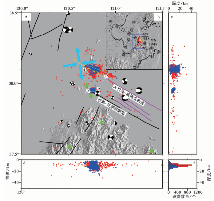 | 图 1 长岛地区的地震分布及构造图 a 地震重定位前、 后的数据分别用红色和蓝色表示, 紫色断层数据来源于王志才等(2006), 蓝色粗箭头表示本文的应力场结果, 震源机制解来源于郑建常等(2013), 绿色三角形表示台站; b 蓝色矩形为本文研究区域; c、 d 红色实心圆为重定位前的地震分布, 蓝色为重定位后的地震分布; e 地震重定位前、 后的地震深度统计图Fig. 1 The distribution of the earthquakes and tectonic map of Changdao area. |
蓬莱-威海断裂带曾发生数次震级较大的地震(王志才等, 2006; 于磊, 2017; 谢卓娟等, 2020), 其中长岛附近曾发生1548年渤海海峡7级地震和1948年威海西北6级地震(图1b)。 由于长岛地区地震频发、 断裂分布密集, 前人在该地区已开展了大量研究(李人杰等, 2002; 王志才等, 2006; 党学会, 2012; 郑建常等, 2013)。 应力场研究结果表明(Wan, 2010; 郑建常等, 2013), 长岛地区的背景应力场以近EW向挤压及SN向拉张为主, 其主要受控于华北应力场。 长岛震群周边分布着由近NW走向的次级断裂组成的复杂断裂带(王志才等, 2006), 结合历史上发生的数次地震(赵金花等, 2009; 谢卓娟等, 2020)分析可知, 该区域存在着孕育中强地震的构造背景(李人杰等, 2002; 田德培等, 2005; 赵金花等, 2009)。
基于前人在该地区的研究成果, 本文对长岛震群2 900余次小地震进行重定位, 拟开展该地区的断层面参数拟合及应力场分析等工作, 所得结果可为了解该地区的发震构造背景等提供参考。
本文基于山东省地震台网2017年2月—2019年4月的监测记录, 搜集了37.5°~38.5°N、 120°~121.5°E范围内深度为0~39km、 震级为ML0.2~4.6的2 927个地震事件。 使用双差方法(Waldhauser et al., 2000)进行重定位之后剩余1 651个地震。 重定位之后地震呈现出集中分布的现象(图1c, d), 主要可分为长岛地区的主震群和南部的小地震群2部分。 重定位之后, 地震的深度统计图显示其更符合正态分布(图1e)。
基于长岛地区的震群分布集中、 线性规律较好的特点, 使用万永革等(2008)提出的模拟退火算法和高斯-牛顿算法相结合的方法计算长岛地区南部与北部震群(图1a)的断层面参数。
本文搜集了2007年10月10日—2018年6月21日期间震中位于37.5°~38.5°N、 120°~121.5°E 范围的地震记录, 共选取了2 518次地震事件, 经处理后共有7 266条P波极性数据参与应力场计算。
长岛震群绝大多数为小地震, 导致单个地震事件的P波初动记录大多仅被部分台站记录到。 由于利用P波初动求解震源机制需要单次地震的大量P波初动记录(万永革等, 2011), 故该地区的大多数小地震的P波初动记录并不能被充分利用。 为此, 本文不再求解单个地震的震源机制解, 而是基于P波初动综合震源机制解法(万永革等, 2011)求解应力场。 此方法的优点是既能充分利用地震事件的所有P波初动, 又避免了求解震源机制解带来的误差(万永革等, 2011)。
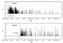
长岛震群由2017年2月开始活动的北部震群和2017年8月开始活动的南部震群组成(图1a, 2)。 本文以38°N为界, 分别对南部与北部震群进行断层面参数拟合。
 | 图 2 南部与北部震群的M-T图Fig. 2 The M-T plot of the southern and northern earthquake swarms. |
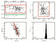
重定位后的北部震群共包含1 432个地震事件, 占所有地震事件的86.74%。 地震分布图(图3a)显示其为NWW-SEE走向的地震群。 地震剖面图显示, 该震群的震源深度介于2~27km(图3b, c)。 根据小地震距断层面距离统计图的结果来看(图3c), 绝大多数地震集中分布于断层面±5km的范围内(图3d)。
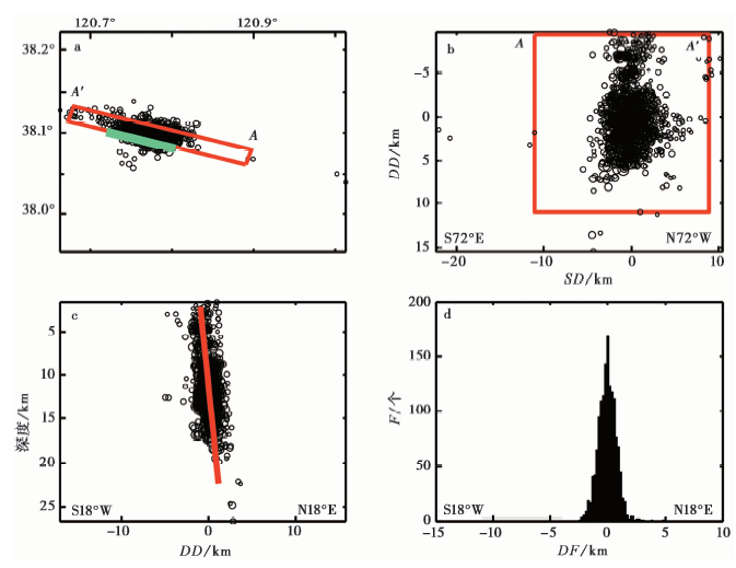 | 图 3 北部震群的地震分布 a 小地震分布在水平面的投影, 绿色粗实线是断层面与地表的交线(断裂); b 地震剖面图投影; c 垂直于断层面的横断面上的投影; d 小地震距断层面距离的分布。SD为走向, DD为倾向, DF为与断层面的距离Fig. 3 The distribution of earthquakes in the northern earthquake swarm. |
计算之后得到的北部震群断层面参数如表1所示。 断层面的走向为287.18°(NWW), 倾角近垂直, 为84.09°。 分析认为拟合得到的断层可能是一条隐伏断层, 很可能是大竹岛-威海北断裂(图 1 中的紫色实线)NWW向的延伸(图 1 中的黄色虚线)。 王志才等(2006)利用声波探测得到的大竹岛-威海北断裂(图 1 中的紫色实线)的走向为295.9°, 倾角近垂直, 如果该断裂向NWW沿伸(图 1 中的黄色虚线)则可以从北部震群附近的区域穿过。 进一步比对后可发现王志才等(2006)得到的大竹岛-威海北断裂的参数与本文结果略微存在偏差, 这可能是由于声波的探测深度(约为0.1km)远小于本文拟合计算的深度(2~27km)。 本文的计算结果为大竹岛-威海北断裂继续向NWW延伸的观点提供了可靠证据。
| 表1 北部震群的断层面参数与前人结果的对比 Table1 The fault plane parameters about the northern earthquake swarm obtained by this paper and their comparison with the previous researches |
重定位后的南部震群共包含219个地震事件, 占所有地震事件的13.26%。 拟合之后得到该震群断层面的走向近EW(图4a), 地震主要分布在剖面图的±2km内(图4b), 横断面(图4c)的倾向为NNW, 地震密集分布在断层面两侧±2km内(图4d)。 南部震群的断层面参数拟合结果显示, 断层面的走向为269.67°(EW向)、 倾角为67.46°, 震源深度为6~11km。
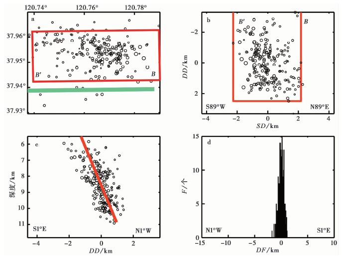 | 图 4 南部震群的地震分布 a 小地震分布在水平面的投影, 绿色粗实线是断层面与地表的交线(断裂); b 地震剖面图投影; c 垂直于断层面的横断面上的投影; d 小地震距断层面距离的分布。 SD为走向, DD为倾向, DF为与断层面的距离Fig. 4 The distribution of earthquakes in the southern earthquake swarm. |
葛孚刚等(2010)在长岛地区获得的野外地质调查结果表明, 该地区存在近EW走向的次级断裂。 石油勘探结果(周建勋等, 2006)也证实渤海湾存在大量的近EW走向的次级断裂。 赵铁虎等(2016)的地质地球物理调查显示这一区域存在近EW走向的断裂。 结合本研究的结果可以得出, 该地区的断层走向269.67°与葛孚刚等(2010)的研究结果一致, 也同石油勘探的结果基本吻合。
本文结果证实了南部与北部震群的发震断层面参数差异较大(表1, 表2), 其原因可能是2个震群的发震机理存在差异。 为此, 本文通过求解南部与北部震群的应力场特征分析南部与北部震群的发震机制。
| 表2 南部震群断层面的参数与前人结果的对比 Table2 The fault plane parameters of the southern earthquake swarm obtained by this paper and their comparison with previous researches |
为了对比相同网格下南部与北部震群应力场的差异性, 采用0.25°×0.25°的网格划分, 分别计算南部与北部震群的应力场, 并分析讨论了应力场特征。 本文采用综合震源机制解法(万永革等, 2011)求解应力场, 得到了P轴(压应力轴)、 T轴(张应力轴)的分布图(图 5)。 基于前人的工作经验, 采用半径50km内的数据计算应力场(万永革等, 2011; 盛书中等, 2015; 闫睿等, 2019)。
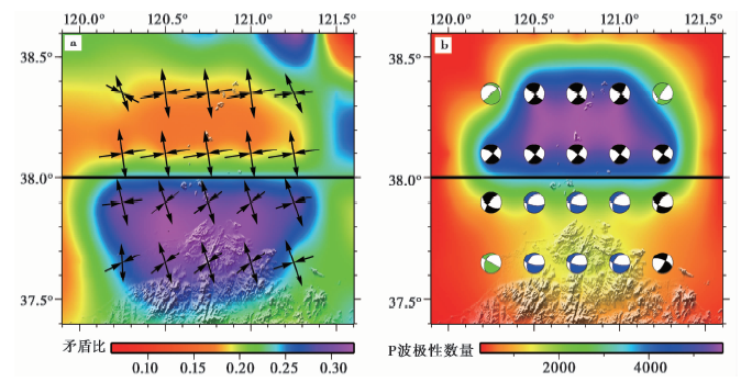 | 图 5 长岛地区的应力场结果 a 黑色箭头表示应力场压、 张应力轴, 颜色表示矛盾比; b 应力场的沙滩球表示形式, 底色表明求取应力场所用的P波极性数量Fig. 5 The results of stress field calculation in Changdao area. |
整体来看, 压应力轴呈NE—NEE向, 张应力轴呈NNW-SSE向以低倾伏角拉张, 与Wan(2010)和郑建常等(2013)得出的长岛地区应力场研究基本相同, 同李兵等(2019)的水压致裂地应力测量一致。 长岛地区的应力场特征与华北大尺度应力场一致(汪素云等, 1980; 许忠淮等, 1983; Wan, 2010; 郑建常等, 2013), 也反映了长岛附近蓬莱-威海断裂带的左旋走滑性质受控于太平洋板块自东向西的推挤作用, 在EW向挤压作用下地壳物质呈SN向拉张逃逸, 进而呈现出近EW向的水平挤压及SN向拉张的应力场特征。
南部与北部震群的应力场参数也存在一定的差异, 局部地区应力场不均匀的特性可能反映了局部地区发震构造的不同(崔华伟等, 2020)。
北部震群应力场(图5a)呈NNW-SSE向近水平拉张、 NEE-SWW向低倾伏角挤压。 应力场的沙滩球示意图(图5b)显示北部震群为走滑型(Zoback, 1992, 崔华伟等, 2019)应力机制, 这与蓬莱-威海断裂的走滑运动特征一致, 可能反映了北部震群的发生受左旋走滑的蓬莱-威海断裂带的控制。
南部震群的压应力轴相对于北部震群发生了逆时针旋转(图5a)。 南部震群的张应力轴与北部震群一致, 但其压应力轴呈NE-SW向挤压、 倾伏角为30°~50°, 与北部震群EW向的压应力轴存在明显的差异。 沙滩球示意图显示, 南部震群呈现以正断为主(Zoback, 1992)兼具走滑成分的应力机制(图5b)。 南部震群的应力场含有部分走滑机制, 说明其可能受到左旋走滑的蓬莱-威海断裂带的控制, 但其应力机制的正断成分可能与该地区存在EW走向张性断层存在一定联系。 有研究显示(Hu et al., 2001), 渤中有大量近EW向的次级断裂带, 这些断裂带受控于近SN向的拉张作用。
张四昌等(1995)统计了渤海地区的震源机制解, 分析之后得出NWW—NW走向的断层为左旋走滑运动; 徐杰等(1998)的研究逐步验证了张家口-蓬莱断裂带是一条左旋走滑性质的断裂带。 本文基于地震资料的观测数据, 验证了长岛地区断层的运动性质。 使用万永革等(2000)提出的根据震源机制解2个节面的走向和倾角求出滑动角的方法, 基于本文得到的北部震群应力场的参数和断层面的走向(287.18°)和倾角(84.09°), 求得北部震群断层面的滑动角为-18.3°(表3)。 根据断层面的走向及滑动角判断, 北部震群的发震断层是NWW向延伸的高倾角左旋走滑断裂。 南部震群的发震断层是近EW走向的左旋走滑次级断裂带。
| 表3 北部与南部震群的断层面滑动角 Table3 The rakes of fault planes of the northern and southern earthquake swarms |
长岛南部与北部震群的距离很近, 约为10km, 但2个震群的断层面参数不同, 且应力机制不同。 为此, 本文将探讨南、 北震群的发震构造背景。
本文的研究结果表明, 长岛北部震群发生在蓬莱-威海断裂带的次级断裂带上, 是NW-SE走向的大竹岛-威海北断裂在NWW向的延伸(图 1)。 北部震群应力场结果显示, 压应力轴呈SWW-NEE向, 张应力轴呈NNW-SSE向, 该区域的应力场为走滑机制(图5b)。 基于本文拟合得到的断层面参数, 使用应力场参数求解的断层面滑动角较小(表3), 判断断层是左旋走滑性质。 而前人的研究结果证实蓬莱-威海断裂带是左旋走滑性质的断裂带(张四昌等, 1995; 徐杰等, 1998; 漆家福等, 2010; 汤良杰等, 2011; 詹润等, 2013)。 综合多方面的研究分析认为, 长岛北部震群是受控于左旋走滑的蓬莱-威海断裂带、 在走滑的应力环境下所发生应力释放的震群活动。 本文的研究结果与李兵等(2019)的研究一致, 均认为长岛附近为走滑应力机制, 有利于走滑断层活化。
南部震群断层面的拟合结果显示该区域存在一条近EW走向(269.67°)的次级断裂, 而应力场呈近SN向水平拉张, 断层面的滑动角为-3.6°, 是左旋走滑性质的次级断裂。 前人的研究证实渤海湾近EW走向的断裂是在近SN向拉张作用下的产物(Allen et al., 1997; 何斌, 2001; 周建勋等, 2006; Zhu et al., 2012; 詹润等, 2013)。 南部震群的应力场存在正断及走滑的应力机制(图5e), 而南部震群也位于左旋走滑的蓬莱-威海断裂带南侧, 北部震群的发生及左旋走滑性质的蓬莱-威海断裂带为南部震群的触发提供了孕育环境。 本文推断南部震群是在近SN向的拉张作用及北部断裂带的触发作用下(图 5), 近EW走向(269.67°)的次级断裂发生错动而形成的。
南部震群与北部震群的断层面均为左旋走滑性质, 主要受左旋走滑的蓬莱-威海断裂带的控制, 但南部震群的应力场含有的正断机制与北部震群不同。 由于南部震群(2017年8月)晚于北部震群(2017年2月)出现, 先出现的北部震群使得近EW向、 近水平的压应力得以释放, 导致后发生的南部震群的应力场压应力轴偏转且出现倾伏角偏大的现象, 显示出以SN向拉张作用为主(Allen et al., 1997; 何斌, 2001; 周建勋等, 2006; Zhu et al., 2012; 詹润等, 2013)。
本文基于长岛地区小地震数据, 经过双差重定位后计算了长岛地区南部与北部2个震群的断层面参数, 并使用P波初动综合震源机制解法得到长岛地区的应力场特征, 根据应力场和断层面参数得到了南部与北部震群断层面的左旋走滑性质。 本研究使用地震观测资料, 从理论上得出发震断层面的运动性质, 结果与断层实际的左旋走滑性质一致, 研究思路可以推广应用到其他震群研究中。 在此基础上, 本文进一步分析了南部与北部2个震群应力场的差异性及发震构造, 得到以下初步结论:
(1)通过拟合得到北部震群的断层面走向为287.18°、 倾角为84.09°, 推断发震断层面很可能是大竹岛-威海北断裂NWW向延伸的隐伏断层。 南部震群的断层面走向为269.67°、 倾角为67.46°。 根据地震的分布特点判断, 南部震群的发震断层可能为一条近EW向的次级断裂。
(2)构造应力场结果显示, 北部震群呈NEE-SWW向挤压及NNW-SSE向拉张状态, 应力场呈走滑机制, 与断裂的左旋走滑特征具有一致性。 南部震群的近EW向断层面和正断兼走滑的应力机制体现了长岛地区局部构造的差异性和应力场的不均匀性。
(3)北部震群发震断层面的滑动角为-18.3°, 具有左旋走滑性质, 受控于左旋走滑性质的蓬莱-威海断裂带。 而南部震群断层面的滑动角为-3.6°, 也属于左旋走滑性质, 受到蓬莱-威海断裂带及SN向拉张作用的控制, 可能是北部震群的持续活动使EW走向(269.67°)的次级断裂发生错动, 进而产生南部小地震群。
致谢 审稿专家对本文提出了宝贵建议和意见; 防灾科技学院万永革教授提供了小地震拟合断层面程序和P波初动求解综合震源机制解法程序; 文中部分图件采用GMT软件绘制(Wessel et al., 1995)。 在此一并表示感谢!
| [1] |
|
| [2] |
|
| [3] |
|
| [4] |
|
| [5] |
|
| [6] |
|
| [7] |
|
| [8] |
|
| [9] |
|
| [10] |
|
| [11] |
|
| [12] |
|
| [13] |
|
| [14] |
|
| [15] |
|
| [16] |
|
| [17] |
|
| [18] |
|
| [19] |
|
| [20] |
|
| [21] |
|
| [22] |
|
| [23] |
|
| [24] |
|
| [25] |
|
| [26] |
|
| [27] |
|
| [28] |
|
| [29] |
|
| [30] |
|
| [31] |
|
| [32] |
|
| [33] |
|
| [34] |
|
| [35] |
|
| [36] |
|
| [37] |
|
| [38] |
|
| [39] |
|
| [40] |
|
| [41] |
|
| [42] |
|
| [43] |
|