
天山地震带主要活动断层现今的滑动速率及其地震矩亏损
[朱爽1)  , 梁洪宝
, 梁洪宝1) , 魏文薪2) , 李经纬1) ]
, 梁洪宝|
|


作者简介: 朱爽, 女, 1987年生, 2012年于武汉大学测绘学院(院所)获大地测量学与测量工程专业硕士学位, 工程师, 主要从事GPS数据分析及地壳形变分析, E-mail:Shzhu1026@163.com。
文中收集了1999—2015年天山地震带及其周边地区的GNSS数据, 计算得到了速度场结果, 并利用弹性块体模型计算了研究区域内各块体的闭锁深度和主要断层的滑动速率。 研究结果表明: 南天山断裂带西段的迈丹断裂的缩短速率处于高值状态, 达(-6.3±1.9)mm/a, 高于南天山东段; 北天山断裂带西段的缩短速率同样高于东段。 利用主要断裂带的滑动速率计算出各地震带的地震矩积累变化及1900年以来的地震矩释放变化量, 以分析地震矩亏损分布, 结果显示北天山山前断裂、 迈丹断裂、 额尔齐斯断裂带北段和喀什河断裂西段存在较大的地震矩亏损, 具有孕育7级以上地震的潜能, 而北轮台断裂、 柯坪断裂带中段则呈现地震矩盈余状态, 在未来的一段时间内不具备发生强震的可能。
Late Cenozoic and modern tectonic deformation in mainland China is mainly characterized by active block movement, and the average slip rate of faults in the fault zone at the block boundary is an important indicator for quantitatively measuring the intensity of fault activity. The Tianshan Mountains, as the largest revival orogenic belt within Eurasia, with crustal movement basically manifesting as near north-south deformation and a large number of strong seismic surface ruptures, is one of the regions with strong tectonic movement and one of the key seismic hazard zones in China. Many experts have conducted relevant studies on the Tianshan region using GPS technology and have obtained some useful conclusions. These studies have not divided and analyzed the fault zone in detail, but only divided the Tianshan seismic zone into several major fault zones, such as the eastern and western sections of the northern Tianshan, and the eastern and western sections of the southern Tianshan. In order to analyze the activity characteristics of the major faults in the Tianshan region more clearly, this paper refines the major faults and selects 14 major active faults in combination with the distribution of active faults in China proposed by Xu Xi-wei et al. 18 blocks are divided into secondary blocks in Tianshan region, with the major active blocks in the Tianshan region taken as the boundary; The GNSS data of the surrounding areas of 1999—2015 in the Tianshan seismic zone are collected in this paper and used to calculate the velocity field results, and the block locking depth and the slip rate of major faults are calculated using the elastic block model to quantify the seismogenic capacity of major faults. Because the fault closure will produce obvious elastic deformation gradient around the fault, the greater the depth of fault closure is, the greater the influence will be. The fault locking depth can be constrained by the method of GPS data fitting of this model, and the influence of fault locking depth is verified by the method of GPS minimum residual RMS in this paper. According to the optimal locking depth obtained in this paper, the velocity field in Tianshan area is simulated and calculated. The residual mean value of the velocity field simulated by the elastic block model is small, and the average velocity error in the east-west direction is 1.57mm/a, the average velocity error in the north-south direction is 1.72mm/a. At the same time, the slip rate of major faults is obtained. The results show that: the horizontal shortening of the whole Tianshan region is significant, which is consistent with the tectonic background of the region, and the shortening value in the southern Tianshan region is higher than that in the northern Tianshan region; the shortening tensile rate is significantly larger than the slip rate, which shows that the fault zone at basin mountain junction in the Xinjiang Tianshan region is dominated by backwash activity; the extrusion rate in the western section of the southern Tianshan fault zone is in a high value state, reaching(-6.3±1.9)mm/a, which is higher than that in the eastern part of the southern Tianshan; the extrusion rate in the western part of the northern Tianshan is also higher than that in the eastern part. All the strong earthquakes of magnitude 8 and more than 80% of the strong earthquakes of magnitude 7 and above in China occurred in the boundary zones of active blocks according to the historical records, the motion characteristics of the boundary zone of active blocks play an important role in controlling the generation and occurrence of earthquakes, and the seismicity of faults may be quantitatively calculated by the loss of seismic moment. In this paper, we collected a list of strong earthquakes of magnitude 6 and above in the Tianshan area since 1900, estimated the seismic moment release of the main faults in the Tianshan seismic zone based on the above list, and compared it with the calculated seismic moment accumulation to obtain the seismic moment loss of the corresponding fault. Among them, the maximum release of seismic moment of the Beiluntai Fault reached 8.69×10¹⁹N·m; due to the release of several moderate and strong earthquakes, the seismic moment of middle of Bo-A Fault and Keping Fault have not reached the deficit state at present, the surplus is -1.85×10¹⁹N·m and -3.06×10¹⁹N·m, respectively; The smallest area of earthquake release is the northern Tianshan mountain front fault, which is only 0.11×10¹⁹N·m, because there was only one earthquake with a magnitude of 6 in 1907, and the earthquake accumulation reached 11.53×10¹⁹N·m, generating an earthquake deficit of 11.42×10¹⁹N·m, which could produce a magnitude of 7.3 earthquake. The results show that front margins of the northern Tianshan Fault, the Maidan Fault, the north section of Ertix Fault and the west of Kashihe Fault have a large seismic moment loss and have the potential to generate earthquakes of magnitude 7 and above, while Beiluntai Fault and the middle section of the Keping Fault show a surplus state, and there is no possibility of a strong earthquake in a certain period of time in the future.
中国大陆晚新生代和现代构造变形以活动地块运动为主要特征, 地块边界处断层的平均滑动速率是定量衡量断层活动强度的重要指标(邓起东等, 2002; 张培震等, 2003)。 天山山脉是欧亚大陆内部规模最大的再生造山带, 东起中国境内的新疆, 西至吉尔吉斯斯坦和塔吉克斯坦(邓起东等, 2000; 周德敏, 2013), 全长约2 500km, 东窄西宽, 其山前或盆地边缘俯冲及逆掩断层发育较强(Avouac et al., 1993; 张培震等, 1996), 地壳运动基本表现为近SN向的变形和大量强震地表破裂, 是中国构造运动较强的地区之一, 也是地震重点危险区之一。
目前, 已有很多专家利用GPS技术对天山地区进行了相关研究, 并取得了一些有益的结果。 Abdrakhmatov等(1996)基于GPS资料得到天山地区的运动速率约为20mm/a, 并认为天山地区现今构造运动的最重要特征之一就是地壳的SN向快速缩短, Larson等(1999, 2003)、 王琪等(2000)和张培震等(2003)也得到了相应的结论。 杨少敏等(2008)利用1992— 2006年天山地震带近400个GPS站点的观测资料获取了天山地震带密集的地壳运动速度场, 并以GPS速度场为约束, 采用二维弹性位错模型反演了区域内主要断层的活动速率; 刘代芹等(2016)采用弹性块体模型基于1998— 2003年的速度场计算了天山地震带的闭锁深度、 块体运动参数和主要断层的滑动速率, 认为北天山断裂带东段有发生7级以上地震的可能性。
然而, 上述研究没有对断裂带进行细致地划分及分析, 只是将天山地震带大致划分为几条主要断裂带, 如北天山东段、 西段, 南天山东段、 西段等。 为了更清晰地分析天山地区主要断裂带的活动特征, 本文对主要断裂带进行了细化, 根据张培震等(2003)提出的中国活动断层分布, 共挑选出14条主要活动断层, 以天山地区主要活动断裂带为边界, 结合中国大陆二级块体的划分, 划分出18个块体, 并深入研究各主要断层的滑动速率及地震矩亏损分布, 从而定量分析主要断层的孕震能力。 本文的预期成果可为天山地区的地震危险性判定提供定量的技术支持。
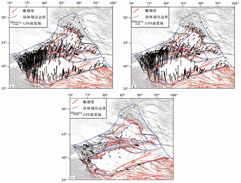
首先, 收集1999— 2015年陆态网GPS连续站与流动站的观测数据及中国周边77个IGS站的数据, 利用GAMIT/GLOBK软件进行GNSS解算, 得到测站坐标及卫星轨道的单日松弛解。 之后, 再利用QOCA软件对上述多个单日松弛解结果进行融合, 选取分布于全球的70个GPS测站作为框架点, 经过平差计算得到ITRF2005框架下的速度场。 在解算过程中, 为减小2001年昆仑山8.1级地震、 2014年2月12日于田7.3级地震的影响, 先利用GPS连续观测数据计算得到上述地震引起的同震位移, 再于求解速度场时扣除同震影响, 最终得到的速度场结果如 图3a所示。
Meade等(2005)提出的弹性线性球面块体模型假设震间期所有的断层均处于闭锁状态, 因此震间期的速度场VI可表示为
其中, VB为块体整体的运动速度; VCSD为块体边界断裂在块体之间发生相对差异运动时由于断层闭锁而产生的同震亏损滑动速率;
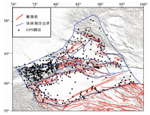
首先, 收集天山地震带的断层地质背景资料, 以地质背景为基础确定14条重点断层。 同时, 以张培震等(2003)给出的中国大陆活动块体划分方案为背景, 以重点断层作为划分弹性块体模型的边界。 由于本文所使用的模型要求所选块体必须闭合, 故在划分块体时对断裂带进行了有选择的合并和删减, 以活动性较强的断裂带为主要断裂带。 对于某些边界没有断裂带的块体, 为使其闭合采用人工的方式设置边界。 按照上述方法, 共划分出18个块体。 同时, 结合本文获取的GPS速度场特征对GPS速度场进行预处理, 选定边界区域内的点, 并剔除离群点。 划分结果如 图 1 所示。
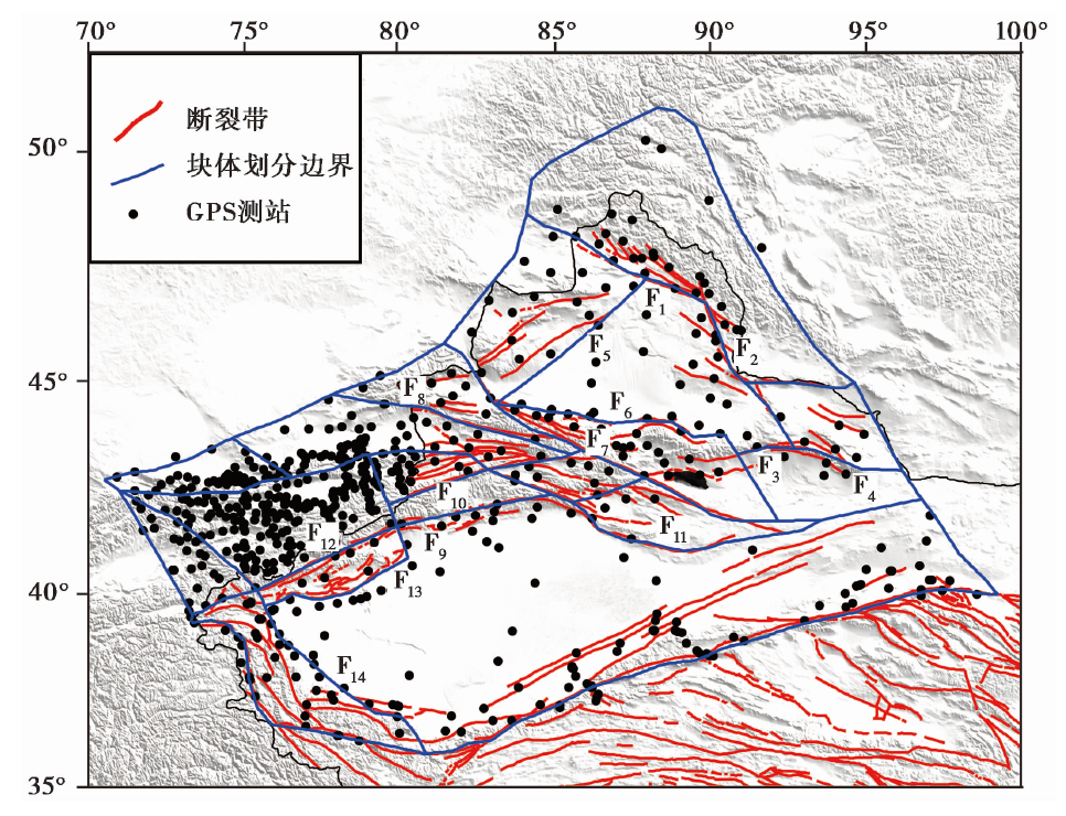 | 图 1 块体划分与GPS点位分布图 F1 额尔齐斯断裂带; F2 可可托海-二台断裂带; F3 洛包泉-碱泉子断裂带; F4 哈密盆地北缘断裂带; F5 达尔布特断裂带; F6 北天山山前断裂带; F7 博阿断裂带; F8 喀什河断裂带; F9 北轮台断裂带; F10 那拉提断裂带; F11 兴地断裂带; F12 迈丹断裂带; F13 柯坪断裂带; F14 泽普断裂带Fig. 1 The configuration of the elastic block model and the location of GPS stations. |
断层的闭锁将在其周围产生明显弹性形变梯度, 且断层闭锁深度越大这种影响就会越大。 断层的闭锁深度可利用本模型通过拟合GPS数据的方法得到限定, 并使GPS的拟合残差RMS最小以验证断层闭锁深度的影响。 本文研究区内的GPS数据拟合程度与断层闭锁深度的变化关系如 图 2 所示。
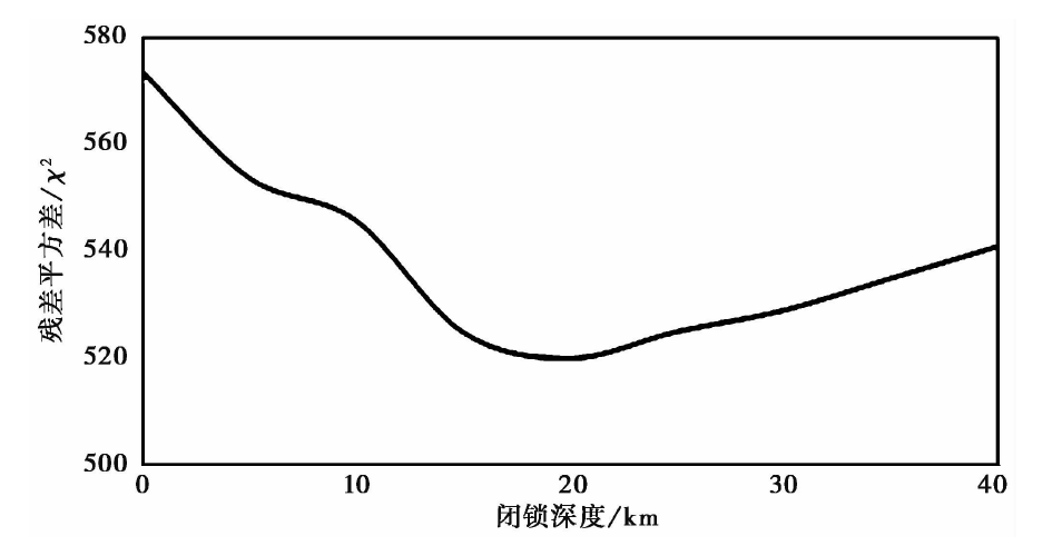 | 图 2 平均最优闭锁深度Fig. 2 The best locking depth. |
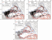
根据前文所得的最优闭锁深度模拟计算了天山地区的速度场, 结果如 图 3 所示。 从图中可以看出, 弹性块体模型模拟的速度场残差均值较小, EW向的平均速率误差为1.57mm/a, SN向的平均速率误差为1.72mm/a。 一些区域的残差较大是由测站本身的观测质量或计算时的粗差引起的。
 | 图 3 GPS速度场及模拟残差分布图 a 块体模型输入速度场; b 块体模型模拟速度场; c 残差速度场Fig. 3 GPS velocity and distribution of residual values. |
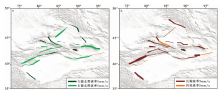
利用前文得到的速度场结果, 通过弹性球面块体模型计算得到了天山地震带主要断裂带的滑动速率, 如 图 4 所示。 图4a中, 浅绿色表示左旋走滑运动趋势, 深绿色表示右旋走滑运动趋势, 线条的宽度对应不同的滑动速率值。 阿尔泰地区的主要断裂带、 斜切天山的博阿断裂带的右旋走滑特征显著, 滑动速率较大, 近EW向的盆山交界构造带及天山中部的断裂带呈左旋走滑活动性质, 速率相对较小。 图4b中, 深红色表示缩短运动, 黄色表示拉张运动, 线条的宽度对应不同的滑动速率值。 整个天山地区的水平缩短特征显著, 与区域的构造背景具有一致性, 并且南天山地区的缩短量值高于北天山地区; 同时, 缩短拉张速率明显大于走滑速率, 表明新疆天山地区的盆山交界断裂带以逆冲活动为主。 另外, 天山中部也显示出了不同程度的缩短特征。 具体结果如 表1所示。
 | 图 4 天山地震带主要断裂的滑动速率 a 走旋结果; b 缩短拉张结果Fig. 4 Simulated slip rate of main faults. |
| 表1 天山地震带主要断裂的滑动速率结果 Table1 Slip rate of main faults in Tianshan region |
阿尔泰地区的额尔齐斯活动断裂带由5条活动断裂构成, 自东向西呈散开状, 延伸约650km, 具右旋走滑逆冲性质(柏美祥, 1996)。 该断裂带自更新世晚期以来均有活动, 地质上其右旋走滑速率为5mm/a, 垂直错动速率为6.25mm/a。 王晓强等(2007)的研究结果显示该断裂带的右旋走滑速率为2~3mm/a; Wang等(2011)计算得到该区域的走滑速率为4.9~7.9mm/a; 刘代芹等(2016)认为该地区阿勒泰断裂的走滑速率为6.8mm/a。 本文计算的额尔齐斯断裂带北段的右旋走滑速率为(0.4± 1.2)mm/a, 水平缩短速率为(3.8± 1.4)mm/a, 南段的右旋走滑速率为(1.8± 0.9)mm/a, 水平缩短速率为(3.2± 1.1)mm/a。 与已有的研究相比, 本文得到的该断裂具有右旋挤压性质的结论与前人一致, 具体速度数值与王晓强等(2007)的结果一致, 但比地质学的结果小, 推测是由于本文只计算了部分额尔齐斯活动断裂带的滑动速率, 且分段进行滑动速率解算将会导致速率的分解。
北天山山前断裂包括独山子-安集海断裂、 霍尔果斯-玛纳斯-吐谷鲁逆断裂、 阜康断裂和博格达山北缘断裂。 本文的计算结果表明该断裂以缩短变形为主, 平均走滑速率为(1.0± 2.2)mm/a, 平均水平缩短速率为(2.6± 2.4)mm/a, 地质上给出的缩短速率为(0.71± 0.06)mm/a(杨晓平等, 2008), 在考虑误差的情况下本文结果与地质结果相近。 洛包泉-碱泉子断裂以逆冲为主, 断裂的滑动速率较小, 晚第四纪以来其左旋运动速率为1~2mm/a(吴富峣, 2016), 本文计算的洛包泉-碱泉子断裂的走滑速率为(4.5± 1.2)mm/a, 水平缩短速率为(1.1± 1.5)mm/a, 后者在考虑误差的情况下与地质结果相同, 但走滑速率明显较大。 哈密盆地北缘断裂同样以逆冲为主, 其滑动速率较小: 北段的走滑速率为(5.6± 1.6)mm/a, 缩短速率为(1.1± 2.1)mm/a; 南段的走滑速率为(5.6± 1.6)mm/a, 缩短速率为(3.5± 1.9)mm/a。 走滑速率之所以明显较大, 可能与此处的测站分布有关系。 前人的研究中大多将此区域统一视为北天山东段。 牛之俊等(2006)认为北天山西段的缩短速率为(2.4± 0.6)mm/a, 北天山东段的缩短速率为(3.6± 1.7)mm/a; 刘代芹等(2016)计算得到的北天山西段的缩短速率为(3.2± 0.5)mm/a, 北天山东段的缩短速率为(4.1± 0.8)mm/a。 经过对比可知, 本文计算的缩短速率与前人结果相一致, 但走滑速率偏大。
博阿断裂带在中国境内的滑动以右旋为主(沈军等, 2003), 速率为4~0.2mm/a, 本文得到的博阿断裂带从北到南的右旋走滑速率为(4.1± 1.4)~(0.5± 2.2)mm/a, 与地质结果一致。
喀什河断裂是由多条断层组成的活动断裂带, 总体以逆冲活动为主, 其东段具有右旋扭错性质(尹光华等, 2003), 在新生代仍有多次活动并以垂直运动为主, 晚第四纪以来的垂直活动速率为0.9~6mm/a。 本文得到的喀什河断裂带西段的右旋走滑速率为(3± 2.2)mm/a, 缩短速率为(3.8± 1.9)mm/a, 东段的左旋走滑速率为(2± 1.2)mm/a, 缩短速率为(2± 2.0)mm/a, 东、 西段的缩短结果与地质学结果相似, 东段的走滑速率结果与地质学结果相反, 有微弱的左旋走滑运动, 这可能与断裂带的分段有关。
北轮台断裂地质上以逆冲为主, 运动速率为0.48~1.52mm/a(姚远等, 2018)。 本文计算的右旋走滑速率为(1.7± 2.0)mm/a, 缩短速率为(0.8± 2.0)mm/a, 与地质结果一致。 那拉提断裂为左旋走滑兼逆冲性质, 本文计算的走滑速率为(1.9± 1.2)mm/a, 缩短速率为(1.4± 1.9)mm/a, 与地质结果的性质一致。
迈丹断裂以左旋逆冲为主, 地质学方法得到的左旋走滑速率为(2.3± 0.61)mm/a, 逆冲滑动速率为(1.24± 0.20)mm/a(吴传勇, 2016)。 本文计算的结果表明其走滑速率为(4.1± 1.7)mm/a, 缩短速率为(6.3± 1.9)mm/a, 断裂带的滑动性质与地质学给出结果一致, 但逆冲分量较地质结果偏大, 这可能与GPS给出的速率为地表速率有关, 也有可能与块体的细分有关。 柯坪断裂以逆冲为主, 地质上认为其缩短速率约为6~7mm/a(吴传勇, 2016), 本文计算的缩短速率接近0.7mm/a, 相对地质结果偏小。 结合文中的块体划分及弹性块体模型的原理分析, 本研究得到的速率应为柯坪推覆体第一层褶皱的速率, 与闵伟等(2006)研究中的单条褶皱的结果一致。
有历史记载以来, 中国全部8级强震和80%以上超过7级的强震都发生在活动地块边界带上。 活动地块边界带的运动特征对地震孕育和发生具有重要的控制作用, 而断层的地震危险性可由地震矩的亏损定量估算。 本研究将讨论的重点定为主要断裂带的地震矩变化, 依据上文中反演得到的断层最优闭锁深度及滑动速度, 计算得到每条断裂带的地震矩积累率, 并结合利用研究区域强震记录估算的地震矩释放情况, 估算主要断裂带的地震矩亏损。
地震矩累计速率可由MO=∑ μ |s|A计算。 其中, s为断层总的滑动速率, 包括其走滑速率和倾滑速率, A为断层面面积, μ 为剪切模量, 在计算中取μ =30GPa。 1次地震释放的地震矩(MO)可利用其矩阵级(MW)由式(2)估算得到。
强震目录的完整和可靠性是估算断层上地震矩释放、 进而估算其地震矩亏损的基础。 本文从相关参考文献中(王海涛等, 2006; M7专项工作组, 2012)收集到1900年以来天山地区6级以上强震目录, 并根据上述强震目录估算了天山地震带主要断裂带的地震矩释放, 进而与计算得到的地震矩积累进行比较, 得到了相应断层的地震矩亏损, 结果详见 表2。
| 表2 主要断裂带的滑动速率及地震矩平衡 Table2 Slip rate and moment balance on main faults |
从 表2中可以看出, 北轮台断裂地震矩释放最大, 达8.69× 10¹⁹N· m; 博阿断裂带中段以及柯坪断裂带中段由于多次中强地震的释放, 目前地震矩未达到亏损状态, 其盈余量分别为-1.85× 10¹⁹N· m和-3.06× 10¹⁹N· m; 地震释放最小的地区为北天山山前断裂, 仅有0.11× 10¹⁹N· m, 此处仅于1907年发生过1次6级地震, 而地震积累达11.53× 10¹⁹N· m, 产生了11.42× 10¹⁹N· m的地震亏损, 可孕育1次7.3级地震。 同理, 迈丹断裂、 额尔齐斯断裂带北段和喀什河断裂西段均存在较大的地震矩亏损, 具有发生7级以上地震的潜能。 北轮台、 柯坪断裂带中段的地震矩呈现出盈余状态, 推测未来一段时间内不具备发生强震的可能。
本文的研究区跨度较大, GPS观测资料周期较长(1999— 2015年), 受观测质量、 GPS测点分布不均匀等因素的影响, 特别是那拉提、 兴地断裂等附近区域的GPS测点较稀疏, 使得滑动速率的解算精度有所降低。 为了提高解算的精确度, 本文在进行块体的详细划分时针对GPS测点较少的区域进行了筛选, 尽量使参与计算的块体内部的GPS测站均匀分布, 满足本文计算模型的需要, 待未来有覆盖密度更大的GPS观测资料时再进行精细研究。 此外, 本文将所得的计算结果与前人的成果进行了对比分析, 同时与地质学结果进行了比较。 事实上, GPS观测时间段的不同将导致滑动速率计算结果出现不同, 前人的计算结果可为本研究提供背景参考。 此外, 基于GPS观测计算得到的是1999— 2015年期间的地表滑动速率, 与地质学长期背景结果有一定的差别。 本文将结合地质背景、 时间因素、 测量因素等进行进一步精细分析。
利用弹性块体模型计算断裂带的滑动速率时, 边界带的选择及块体的划分对结果有显著影响。 一些学者在开展相关研究时对天山地区进行了大致的划分。 朱红彬(2010)将新疆地区视作1个块体进行研究; 张培震等(2003)将新疆地区分为3大块体; 张国民等(2005)将新疆地区分为4个块体; 牛之俊等(2006)则将其划分为东、 西天山2个块体; 刘代芹等(2016)在前人的基础之上进行了细划, 共划分为塔里木、 天山(西)、 天山(东)、 阿尔泰等8个块体。 本文在其研究的基础上, 结合天山地区活动构造的地质背景, 将研究区划分为18个块体、 14条主要活动断裂带进行分析。 但是, 对块体进行细分将导致块体内部的GPS测站分布不均匀, 造成数据对反演结果的约束不足; 另外, 对于GPS观测资料而言, 断裂带及段落划分过细同样影响数据对反演结果的约束力, 导致部分断层的解算结果与地质结果不一致。 待未来有覆盖密度更大的GPS观测资料时再结合GPS测站的分布情况重新精细划分块体, 将会得到更精确的结果。
此外, 断层的闭锁深度及产状倾斜程度也会对结果产生一定的影响。 由于断层的闭锁会在断层周围产生明显弹性形变梯度, 且当断层闭锁深度越大时这种影响就会越大, 在利用弹性块体模型进行计算时, 断层的闭锁深度可通过基于模型拟合GPS数据的方法得到限定, 通过试算使GPS的残差RMS最小, 可验证断层闭锁深度的影响。 本文在地质背景的基础上, 仅拟合出该区域的平均闭锁深度, 并未对每条断裂带的闭锁深度进行拟合, 故得到的各断层闭锁深度的精度有所降低。 同时, 断层的产状倾斜程度和向深部地壳的延伸状态对滑动速率的计算也有一定的影响, 本文中仅考虑了断裂带的基本几何参数, 同样将导致计算的滑动速率精度有所降低。
利用地震矩进行强震中— 长期危险性研究时, 地震目录是否完整将对结果产生较大的影响, 本文目前收集到1900年以来天山地区相对较完整的6级强震目录, 但其中博阿断裂带中南段和兴地断裂等未有大地震的记录, 可能会对结果造成一定的影响。
刘代芹等(2016)计算了天山地区9个地震带的地震矩亏损情况, 认为阿勒泰地震带上的地震矩盈余量最大, 目前不具备孕育6级以上地震的能力。 本文认为额尔齐斯断裂带北段有发生7级以上地震的可能性, 可可托海-二台断裂有发生6级以上地震的潜能, 这主要是由于本文对地震带进行了细分, 将阿勒泰地区的地震矩释放分配到了各个地震带上。 从 表2中可以看出, 阿勒泰地区的齐斯断裂带南段有大量盈余, 如果将这些断裂带合为一体, 则所得结果将与刘代芹等(2016)的结论一致。 同理, 南天山西段有较多地震发生, 但是发震断裂集中在柯坪断裂中段, 相应的地震矩释放也集中在此段, 导致迈丹断裂及柯坪断裂东、 西段地震矩释放不足, 存在大量的地震矩亏损。
本文基于1999— 2015年天山区域GNSS水平速度场, 利用弹性块体模型计算了块体的闭锁深度和主要断层的滑动速率。 研究结果表明: 斜切天山的博阿断裂带右旋走滑特征显著, 速率较大, 近EW向的盆山交界构造带及天山中部的断裂带呈左旋走滑活动性质, 速率相对较小; 整个天山地区的挤压特征显著, 与区域的构造背景具有一致性, 且南天山地区的缩短量值高于北天山地区; 挤压拉张速率明显大于走滑速率, 显示新疆天山地区的盆山交界断裂带以逆冲活动为主; 南天山断裂带西段的迈丹断裂带的缩短速率处于高值状态, 达(-6.3± 1.9)mm/a, 高于南天山东段; 北天山断裂带西段的缩短速率同样高于东段。
本研究进一步利用主要断裂带的滑动速率计算出各地震带的地震矩积累变化, 基于天山地区1900年以来的历史强震目录计算了对应的地震矩释放变化量, 对地震矩亏损分布开展了分析, 并在此基础之上确定了天山地震带地震矩亏损明显的断裂带。 研究结果显示: 博阿断裂带中段、 北轮台断裂带以及柯坪断裂带中段由于经过多次中强地震的释放, 地震矩未达到亏损状态, 还存在大量的盈余, 推测未来一段时间内不具备发生强震的可能。 相对而言, 北天山山前断裂、 迈丹断裂、 额尔齐斯断裂带北段和喀什河断裂西段存在大量地震矩亏损, 具有发生7级以上地震的潜能。
| [1] |
|
| [2] |
|
| [3] |
|
| [4] |
|
| [5] |
|
| [6] |
|
| [7] |
|
| [8] |
|
| [9] |
|
| [10] |
|
| [11] |
|
| [12] |
|
| [13] |
|
| [14] |
|
| [15] |
|
| [16] |
|
| [17] |
|
| [18] |
|
| [19] |
|
| [20] |
|
| [21] |
|
| [22] |
|
| [23] |
|
| [24] |
|
| [25] |
|
| [26] |
|
| [27] |
|
| [28] |
|