
SEISMOLOGY AND GEOLOGY ›› 2022, Vol. 44 ›› Issue (1): 188-204.DOI: 10.3969/j.issn.0253-4967.2022.01.012
• Research paper • Previous Articles Next Articles
THE BURIED CO-SEISMIC RUPTURE EXPLORATION USING SEISMIC REFLECTION PROFILE: A CASE STUDY OF THE MS6.2 SOUTH TAIWAN STRAITS EARTHQUAKE IN 2018
WANG Sun1)( ), QIU Xue-lin2),3), ZHAO Ming-hui2),3), YAO Dao-ping1), ZHANG Yi-feng4), YAN Pei1), JIN Zhen4)
- 1) Xiamen Marine Seismic Station, Fujian Earthquake Agency, Xiamen 361021, China
2) Key Laboratory of Ocean and Marginal Sea Geology, Innovation Academy of South China Sea Ecology and Environmental Engineering, South China Sea Institute of Oceanology, Chinese Academy of Sciences, Guangzhou 511458, China
3) Institute of Deep-sea Science and Engineering, Guangzhou 511458, China
4) Xiamen Institute of Marine Seismology, China Earthquake Administration, Xiamen 361021, China
-
Received:2021-02-22Revised:2021-07-06Online:2022-02-20Published:2022-04-20
利用反射地震剖面探查隐伏同震破裂——以2018年台湾海峡南部MS6.2地震为例
王笋1)(), 丘学林2),3), 赵明辉2),3), 姚道平1), 张艺峰4), 闫培1), 金震4)
- 1)福建省地震局海洋地震观测中心, 厦门 361021
2)中国科学院边缘海与大洋地质重点实验室, 中国科学院南海生态环境工程创新研究院,中国科学院南海海洋研究所, 广州 511458
3)南方海洋科学与工程广东省实验室, 广州 511458
4)中国地震局厦门海洋地震研究所, 厦门 361021
-
作者简介:王笋, 男, 1984年生, 2019年于中国科学院南海海洋研究所获海洋地质专业博士学位, 工程师, 主要从事地震构造探测研究, 电话: 18859243971, E-mail: attaol@163.com。 -
基金资助:中国地震局地震科技星火计划项目(XH19022Y);国家自然科学基金(41774104);福建省地震局科技基金(SF202104)
CLC Number:
Cite this article
WANG Sun, QIU Xue-lin, ZHAO Ming-hui, YAO Dao-ping, ZHANG Yi-feng, YAN Pei, JIN Zhen. THE BURIED CO-SEISMIC RUPTURE EXPLORATION USING SEISMIC REFLECTION PROFILE: A CASE STUDY OF THE MS6.2 SOUTH TAIWAN STRAITS EARTHQUAKE IN 2018[J]. SEISMOLOGY AND GEOLOGY, 2022, 44(1): 188-204.
王笋, 丘学林, 赵明辉, 姚道平, 张艺峰, 闫培, 金震. 利用反射地震剖面探查隐伏同震破裂——以2018年台湾海峡南部MS6.2地震为例[J]. 地震地质, 2022, 44(1): 188-204.
share this article
Add to citation manager EndNote|Ris|BibTeX
URL: https://www.dzdz.ac.cn/EN/10.3969/j.issn.0253-4967.2022.01.012
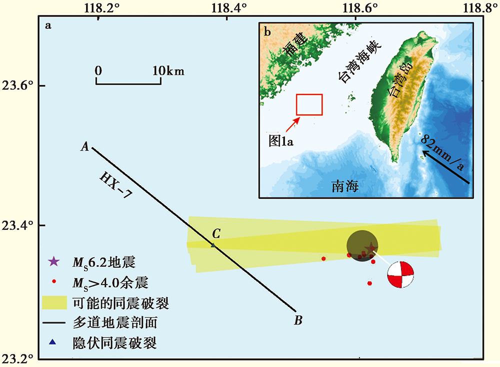
Fig. 1 Distribution of the epicenter, aftershocks and possible co-seismic rupture zone of the MS6.2 earthquake in 2018(a), the tectonic background of the study area(b).
| 参数 | 2017年资料 | 2019年资料 |
|---|---|---|
| 震源 | G型气枪阵列 | 12kJ电火花 |
| 炮点距 | 37.5m | 12.5m |
| 记录仪器 | 408XL | NTRS-3 |
| 采样间隔 | 1ms | 0.5ms |
| 漂缆型号 | Sentinel固态 | Seamux-2充油 |
| 道距 | 12.5m | 12.5m |
| 接收道数 | 108 | 30 |
| 偏移距 | 81~1 418.5m | -19.5~343.5m |
| 漂缆深度 | 6m | 1~22m |
Table 1 Comparison of the acquisition parameters
| 参数 | 2017年资料 | 2019年资料 |
|---|---|---|
| 震源 | G型气枪阵列 | 12kJ电火花 |
| 炮点距 | 37.5m | 12.5m |
| 记录仪器 | 408XL | NTRS-3 |
| 采样间隔 | 1ms | 0.5ms |
| 漂缆型号 | Sentinel固态 | Seamux-2充油 |
| 道距 | 12.5m | 12.5m |
| 接收道数 | 108 | 30 |
| 偏移距 | 81~1 418.5m | -19.5~343.5m |
| 漂缆深度 | 6m | 1~22m |
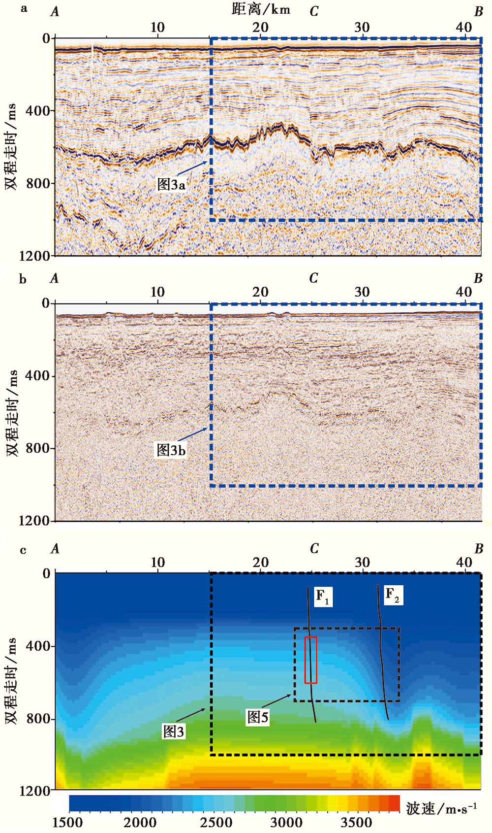
Fig. 2 Multi-channel seismic profile migrated from all offsets.
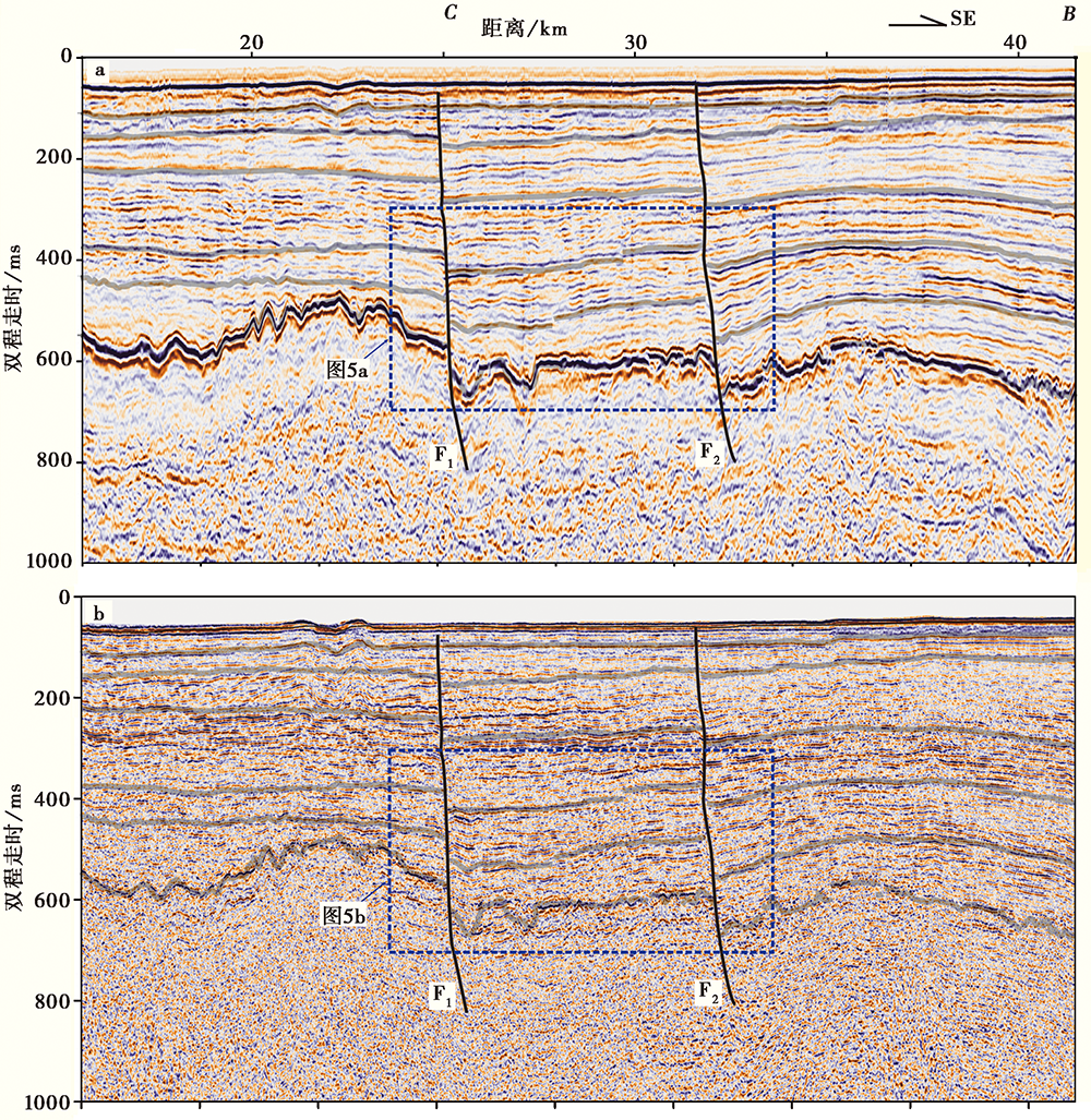
Fig. 3 Remarkable reflections and faults in stratigraphic interpretation.
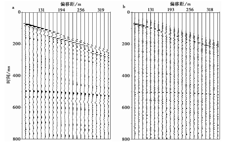
Fig. 4 Comparison of the common shot gathers.
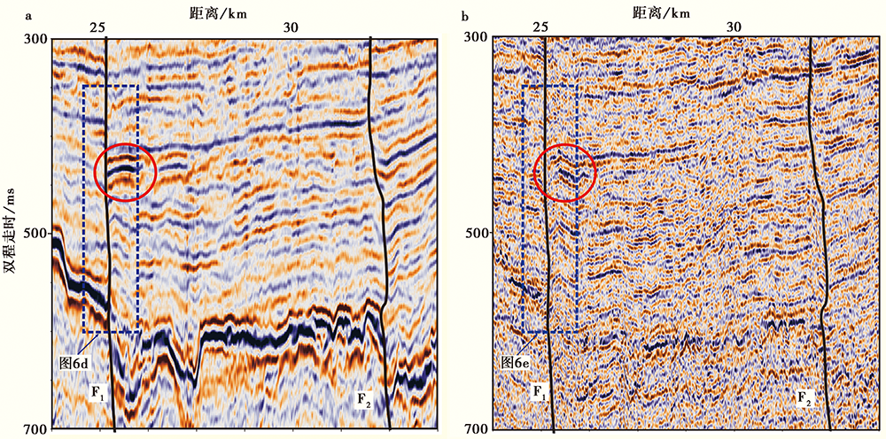
Fig. 5 Co-seismic displacements along the Fault F1.
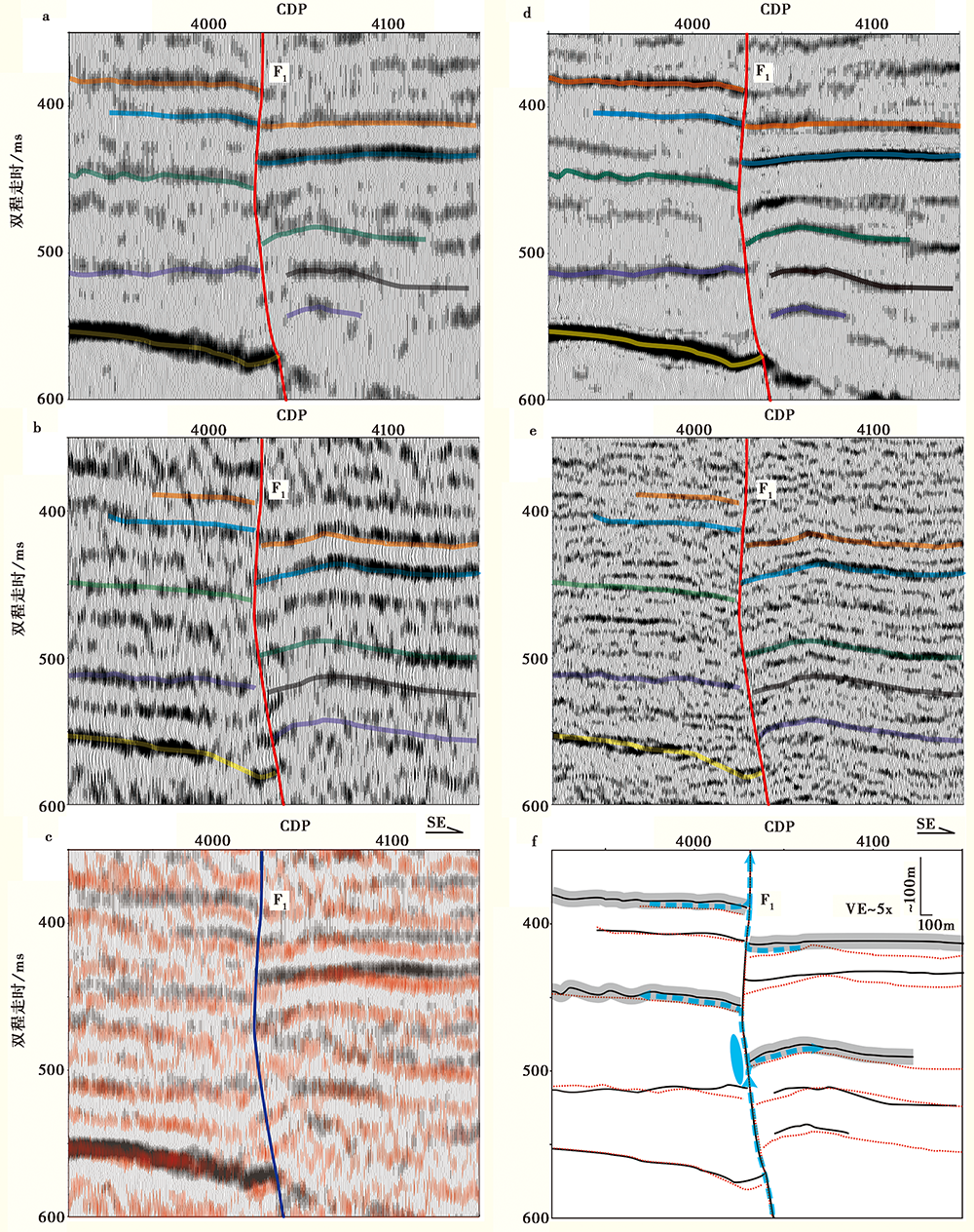
Fig. 6 The waveform display of the details along the Fault F1.
| [1] | 邓起东, 于贵华, 叶文华. 1992. 地震地表破裂参数与震级关系的研究 [G]// 国家地震局地质研究所编. 活动断裂研究(2), 北京: 地震出版社: 247-264. |
| DENG Qi-dong, YU Gui-hua, YE Wen-hua. 1992. Study on the relations between parameters of surface rupture and magnitude[G]// Institute of Geology, SSB(ed). Research of Active Fault (2). Seismological Press, Beijing: 247-264. (in Chinese) | |
| [2] | 丁维凤, 李家彪, 高金耀, 等. 2017. 浅水无定位拖缆观测系统定义及多次波压制效果分析[J]. 地球物理学报, 60(9): 3685-3692. |
| DING Wei-feng, LI Jia-biao, GAO Jin-yao, et al. 2017. Definition of seismic geometry for short non-position receivers and multiples attenuation in shallow water[J]. Chinese Journal of Geophysics, 60(9): 3685-3692. (in Chinese) | |
| [3] | 傅志飞, 姜雄鹰, 王海平, 等. 2012. 台西盆地西部坳陷地质特征及油气前景[J]. 海洋地质前沿, 28(7): 30-35. |
| FU Zhi-fei, JIANG Xiong-ying, WANG Hai-ping, et al. 2012. Geological features and hydrocarbon prospect of the western depression, Taixi Basin[J]. Marine Geology Frontiers, 28(7): 30-35. (in Chinese) | |
| [4] | 虢顺民, Tapponnier P, 陈志泰, 等. 1990. 阿尔及利亚阿斯南地震地表破裂特征及古地震事件研究[J]. 地震学报, 12(4): 389-398. |
| GUO Shun-min, Tapponnier P, CHEN Zhi-tai, et al. 1990. Characteristics of surface rupture of El Asnam(Algeria)earthquake and the study of paleoseismic events[J]. Acta Seismologica Sinica, 12(4): 389-398. (in Chinese) | |
| [5] |
郝海健, 何宏林, 魏占玉, 等. 2017. 同震地表破裂及活动断层迹线的几何形貌特征[J]. 地震地质, 39(6): 1267-1282. doi: 10.3969/j.issn.0253-4967.2017.06.012.
DOI |
| HAO Hai-jian, HE Hong-lin, WEI Zhan-yu, et al. 2017. Geometric characteristics of co-seismic surface ruptures and active faults[J]. Seismology and Geology, 39(6): 1267-1282. (in Chinese) | |
| [6] | 何玉梅, 郑天愉. 1998. 利用地震波形反演研究震源破裂时空过程[J]. 地球物理学报, 41(2): 281-289. |
| HE Yu-mei, ZHENG Tian-yu. 1998. Investigation of earthquake rupture histories using waveform inversion method[J]. Chinese Journal of Geophysics, 41(2): 281-289. (in Chinese) | |
| [7] | 侯成福, 高书琴, 蒋连斌. 2008. 红海玄武岩覆盖区拖缆地震采集技术[J]. 石油地球物理勘探, 43(3): 247-251. |
| HOU Cheng-fu, GAO Shu-qin, JIANG Lian-bin. 2008. Technology of streamer seismic data acquisition in basalt-overlaid area, Red Sea[J]. Oil Geophysical Prospecting, 43(3): 247-251. (in Chinese) | |
| [8] | 栗宝鹃, 董春梅, 林承焰, 等. 2016. 砂泥岩薄互层层位精细标定方法及应用: 以东营凹陷滨东地区沙四上亚段为例[J]. 石油地球物理勘探, 51(1): 173-182. |
| LI Bao-juan, DONG Chun-mei, LIN Cheng-yan, et al. 2016. Sand-shale interbed refined calibration: An example of Bindong beach-bar sandstone in Dongying Depression[J]. Oil Geophysical Prospecting, 51(1): 173-182. (in Chinese) | |
| [9] | 李国永, 徐波, 刘丽芳. 2007. 台西盆地烃源岩特征及天然气成藏条件[J]. 天然气工业, 27(5): 48-51. |
| LI Guo-yong, XU Bo, LIU Li-fang. 2007. Source rock characteristics and gas reservoiring conditions in West Taiwan Basin[J]. Natural Gas Industry, 27(5): 48-51. (in Chinese) | |
| [10] | 李秀菊, 李鸿晶. 2012. 断层错动引起的上覆土体破裂演化规律研究[J]. 地震学报, 34(6): 858-864. |
| LI Xiu-ju, LI Hong-jing. 2012. Analysis of rupture propagation in overlying soil due to fault movement[J]. Acta Seismologica Sinica, 34(6): 858-864. (in Chinese) | |
| [11] | 李颖灿. 2013. Sentinel固体电缆降噪原理[J]. 物探装备, 23(1): 15-18. |
| LI Ying-can. 2013. Noise reduction principle for Sentinel solid streamer[J]. Equipment for Geophysical Prospecting, 23(1): 15-18. (in Chinese) | |
| [12] | 鲁人齐, 何登发, Suppe J, 等. 2011. 龙门山中段彭灌断裂带汶川 MS8.0 地震同震破裂断层识别及其浅、 表构造特征[J]. 地质科学, 46(3): 607-619. |
| LU Ren-qi, HE Deng-fa, Suppe J, et al. 2011. Distinguish the co-seismic fault of the MS8.0 Wenchuan earthquake from the Pengguan thrust belt and analyze its shallow structures in the central Longmen Mountains[J]. Chinese Journal of Geology, 46(3): 607-619. (in Chinese) | |
| [13] | 骆迪, 蔡峰, 吴志强, 等. 2019. 海洋短排列高分辨率多道地震高精度成像关键技术[J]. 地球物理学报, 62(2): 730-742. |
| LUO Di, CAI Feng, WU Zhi-qiang, et al. 2019. The key technologies of marine small scale high resolution multichannel seismic high precision imaging[J]. Chinese Journal of Geophysics, 62(2): 730-742. (in Chinese) | |
| [14] | 彭己君, 张金川, 张鹏, 等. 2014. 台西盆地致密砂岩气存在的可能性[J]. 海洋地质前沿, 30(6): 33-39. |
| PENG Ji-jun, ZHANG Jin-chuan, ZHANG Peng. 2014. Possible tight sandstone gas reservoirs in Taixi Basin[J]. Marine Geology Frontiers, 30(6): 33-39. (in Chinese) | |
| [15] | 王辉, 强祖基, 袁著忠, 等. 1991. 1988年云南澜沧-耿马地震的烈度分布及地表破裂[J]. 地震学报, 13(3): 344-353. |
| WANG Hui, QIANG Zu-ji, YUAN Zhu-zhong, et al. 1991. The distribution of seismic intensities and surface rupture in the Lancang-Gengma(Yunnan Province, China)earthquakes of Nov 6, 1988[J]. Acta Seismologica Sinica, 13(3): 344-353. (in Chinese) | |
| [16] | 王笋, 姚道平, 方伟华, 等. 2017. 漳浦外海新生代沉积基底的地震重力综合研究[J]. 地球物理学进展, 32(5): 2241-2245. |
| WANG Sun, YAO Dao-ping, FANG Wei-hua, et al. 2017. Cenozoic sedimentary basement off the coast of Zhangpu: A joint interpretation of seismic and gravity data[J]. Progress in Geophysics, 32(5): 2241-2245. (in Chinese) | |
| [17] | 王小娜, 叶秀薇, 黄元敏, 等. 2019. 2018年11月26日台湾海峡 MS6.2 地震发震构造研究[J]. 地球物理学报, 62(12): 4673-4683. |
| WANG Xiao-na, YE Xiu-wei, HUANG Yuan-min, et al. 2019. Seismogenic structure of the MS6.2 Taiwan Strait earthquake on 26 November, 2018[J]. Chinese Journal of Geophysics, 62(12): 4673-4683. (in Chinese) | |
| [18] | 熊晓军, 贺振华, 文晓涛, 等. 2007. 偏移速度误差引起的假象分析[J]. 西南石油大学学报, 29(6): 24-26. |
| XIONG Xiao-jun, HE Zhen-hua, WEN Xiao-tao, et al. 2007. Analysis of pseudo phenomena caused by migration velocity error[J]. Journal of Southwest Petroleum University, 29(6): 24-26. (in Chinese) | |
| [19] | 徐锡伟, 陈桂华, 于贵华, 等. 2010. 5·12汶川地震地表破裂基本参数的再论证及其构造内涵分析[J]. 地球物理学报, 53(10): 2321-2336. |
| XU Xi-wei, CHEN Gui-hua, YU Gui-hua, et al. 2010. Reevaluation of surface rupture parameters of the 5·12 Wenchuan earthquake and its tectonic implication for Tibetan uplift[J]. Chinese Journal of Geophysics, 53(10): 2321-2336. (in Chinese) | |
| [20] |
薛莲, 孙建宝, 沈正康. 2011. 2010年1月12日海地 MW7.0 地震InSAR同震形变观测及同震滑动分布反演[J]. 地震地质, 33(1): 157-174. doi: 10.3969/j.issn.0253-4967.2011.01.016.
DOI |
| XUE Lian, SUN Jian-bao, SHEN Zheng-kang. 2011. InSAR coseismic deformation observation of the Jan 12th, 2010 Haiti earthquake and its coseismic slip distribution inversion[J]. Seismology and Geology, 33(1): 157-174. (in Chinese) | |
| [21] | 薛艳, 刘杰, 刘双庆. 2018. 全球浅源巨大地震序列统计特征[J]. 中国地震, 34(4): 676-694. |
| XUE Yan, LIU Jie, LIU Shuang-qing. 2018. Statistical characteristics of the global great shallow-focus earthquake sequences[J]. Earthquake Research in China, 34(4): 676-694. (in Chinese) | |
| [22] | 杨肖琪, 宋文隆, 陈承惠. 1996. 台湾海峡地质构造特征[J]. 台湾海峡, 15(2): 127-136. |
| YANG Xiao-qi, SONG Wen-long, CHEN Cheng-hui. 1996. Characteristics of geological structure in Taiwan Strait[J]. Journal of Oceanography in Taiwan Strait, 15(2): 127-136. (in Chinese) | |
| [23] | 姚振兴, 郑天愉, 温联星. 1994. 用P波波形资料反演中强地震地震矩张量的方法[J]. 地球物理学报, 37(1): 36-44. |
| YAO Zhen-xing, ZHENG Tian-yu, WEN Lian-xing. 1994. Moment tensor inversion method for determining the earthquake process by the use of P-wave form data[J]. Chinese Journal of Geophysics, 37(1): 36-44. (in Chinese) | |
| [24] | 张丽娜, 储日升, 曾祥方. 2019. 利用海底地震仪和陆地固定台站记录联合研究2016年6月18日福建漳浦海域 MS3.3 地震震源参数[J]. 地球物理学进展, 34(1): 35-41. |
| ZHANG Li-na, CHU Ri-sheng, ZENG Xiang-fang. 2019. Joint inversion source parameters of June 18, 2016 MS3.3 earthquake in Zhangpu, Fujian Province with OBS and inland stations data[J]. Progress in Geophysics, 34(1): 35-41. (in Chinese) | |
| [25] | 支家生, 王本善. 1996. 台湾西部地层与烃源岩潜力评估[J]. 中国海上油气(地质), 10(4): 237-243. |
| ZHI Jia-sheng, WANG Ben-shan. 1996. Strata of western Taiwan and source potential assessment[J]. China Offshore Oil and Gas(Geology), 10(4): 237-243. (in Chinese) | |
| [26] | 钟建强, 黄慈流, 詹文欢, 等. 1996. 台西盆地新生代构造的演化[J]. 海洋与湖沼, 27(3): 271-278. |
| ZHONG Jian-qiang, HUANG Ci-liu, ZHAN Wen-huan, et al. 1996. Cenozoic tectonic evolution in Taixi Basin[J]. Oceanologia et Limnologia Sinica, 27(3): 271-278. (in Chinese) | |
| [27] | Anderson R N, Boulanger A, He W, et al. 1997. 4-D seismic: The fourth dimension in reservoir management. Part 1: What is 4-D and how does it improve recovery efficiency?[J]. World Oil, 218(3): 43-48. |
| [28] | Armijo R, Pondard N, Meyer B, et al. 2005. Submarine fault scarps in the Sea of Marmara pull-apart(North Anatolian Fault): Implications for seismic hazard in Istanbul[J]. Geochemistry, Geophysics, Geosystems, 6: Q06009. |
| [29] |
Arriagada C, Arancibia G, Cembrano J, et al. 2011. Nature and tectonic significance of co-seismic structures associated with the MW8.8 Maule earthquake, central-southern Chile forearc[J]. Journal of Structural Geology, 33(5): 891-897. doi: 10.1016/j.jsg.2011.03.004.
DOI URL |
| [30] |
Ferber R G. 1994. Migration to multiple offset and velocity analysis[J]. Geophysical Prospecting, 42(2): 99-112. doi: 10.1111/j.1365-2478.1994.tb00200.x.
DOI URL |
| [31] |
Han S, Li H B, Pan J W, et al. 2019. Co-seismic surface ruptures in Qiangtang Terrane: Insight into Late Cenozoic deformation of central Tibet[J]. Tectonophysics, 750:359-378.
DOI URL |
| [32] |
Honarvar F, Sheikhzadeh H, Moles M, et al. 2004. Improving the time-resolution and signal-to-noise ratio of ultrasonic NDE signals[J]. Ultrasonics, 41(9): 755-763.
DOI URL |
| [33] |
Jayangondaperumal R, Thakur V C. 2008. Co-seismic secondary surface fractures on southeastward extension of the rupture zone of the 2005 Kashmir earthquake[J]. Tectonophysics, 446:61-76.
DOI URL |
| [34] |
Lin A, Rao G, Jia D, et al. 2011. Co-seismic strike-slip surface rupture and displacement produced by the 2010 MW6.9 Yushu earthquake, China, and implications for Tibetan tectonics[J]. Journal of Geodynamics, 52(3-4): 249-259. doi: 10.1016/j.jog.2011.01.001.
DOI URL |
| [35] |
Lin A, Sano M, Yan B, et al. 2015. Co-seismic surface ruptures produced by the 2014 MW6.2 Nagano earthquake, along the Itoigawa-Shizuoka tectonic line, central Japan[J]. Tectonophysics, 656:142-153. doi: 10.1016/j.tecto.2015.06.018.
DOI URL |
| [36] |
Lin A T, Watts A B. 2002. Origin of the West Taiwan Basin by orogenic loading and flexure of a rifted continental margin[J]. Journal of Geophysical Research, 17:1-19.
DOI URL |
| [37] |
Lin A T, Watts A B, Hesselbo S P. 2003. Cenozoic stratigraphy and subsidence history of the South China Sea margin in the Taiwan region[J]. Basin Research, 15:453-478.
DOI URL |
| [38] |
Lumley D E, Behrens R A, Wang Z J. 1997. Assessing the technical risk of a 4-D seismic project[J]. The Leading Edge, 16(9): 1287-1292. doi: 10.1190/1.1437784.
DOI URL |
| [39] |
Luo J, Evans S G, Pei X, et al. 2020. Anomalous co-seismic surface effects produced by the 2014 MW6.2 Ludian earthquake, Yunnan, China: An example of complex faulting related to Riedel shear structures[J]. Engineering Geology, 266:105476. doi: 10.1016/j.enggeo.2020.105476.
DOI URL |
| [40] | Raymer L, Hunt E, Gardner J S. 1980. An improved sonic transit time-to-porosity transform[C]. Proceedings of Society of Petrophysicists and Well-Log Analysts, Houston: 1-13. |
| [41] | Smith M, Perry G, Stein J, et al. 2008. Extending seismic bandwidth using the continuous wavelet transform[J]. First Break, 26:97-102. |
| [42] |
Walters R J, Gregory L C, Wedmore L N J, et al. 2018. Dual control of fault intersections on stop-start rupture in the 2016 central Italy seismic sequence[J]. Earth and Planetary Science Letters, 50:1-14.
DOI URL |
| [43] |
Wang Q, Qiao X J, Lan Q G, et al. 2011. Rupture of deep faults in the 2008 Wenchuan earthquake and uplift of the Longmen Shan[J]. Nature Geoscience, 4(9): 634-640.
DOI URL |
| [44] | Wever A, Spetzler J. 2004. Criteria for source and receiver positioning in time-lapse seismic acquisition[C]. 74th SEG Technical Program Expanded Abstracts, 23(1): 2586. |
| [45] |
Yu H S. 2004. Nature and distribution of the deformation front in the Luzon Arc-Chinese continental margin collision zone at Taiwan[J]. Marine Geophysical Researches, 25:109-122.
DOI URL |
| [46] |
Yu S B, Kuo L C. 1999. GPS observation of crustal deformation in the Taiwan-Luzon region[J]. Geophysical Research Letters, 26(7): 923-926.
DOI URL |
| [1] | CAO Ying, QIAN Jia-wei, HUANG Jiang-pei, ZHANG Guo-quan, FU Hong. P-WAVE VELOCITY CHANGES IN HYPOCENTER REGION OF THE 2014 JINGGU MS6.6 EARTHQUAKE USING TIME-LAPSE TOMOGRAPHY BASED ON DOUBLE-DIFFERENCE TOMOGRAPHY [J]. SEISMOLOGY AND EGOLOGY, 2021, 43(6): 1563-1585. |
| [2] | CHEN Gui-hua, MIN Wei, SONG Fang-min, JIAO De-cheng, XU Hong-tai. PRESERVATION OF CO-SEISMIC SURFACE RUPTURE IN DIFFERENT GEOMORPHOLOGICAL SETTINGS FROM THE STUDY OF THE 1786 MOXI EARTHQUAKE [J]. SEISMOLOGY AND GEOLOGY, 2011, 33(4): 804-817. |
| Viewed | ||||||
|
Full text |
|
|||||
|
Abstract |
|
|||||
Copyright © SEISMOLOGY AND GEOLOGY, All Rights Reserved.
Tel: 010-62009049/9063 E-mail: dzdz@ies.ac.cn
Powered by Beijing Magtech Co., Ltd.