
SEISMOLOGY AND GEOLOGY ›› 2025, Vol. 47 ›› Issue (5): 1477-1493.DOI: 10.3969/j.issn.0253-4967.2025.05.20240100
PRELIMINARY STUDY ON LATE QUATERNARY ACTIVITY OF THE EASTERN SEGMENT OF THE NORTHERN MARGIN FAULT OF THE HAMI BASIN
ZHAO Xue-feng1)( ), SHEN Jun1,3),*(), JU Guang-hong2), MA Fei-peng2), ZHAO Wen-gang2), SONG Xu1)
- 1)Institute of Disaster Prevention, Sanhe 650201, China
2)POWERCHINA Northwest Engineering Corporation Limited., Xi'an 710100, China
3)Hebei Key Laboratory of Earthquake Dynamics, Sanhe 650201, China
-
Received:2024-08-03Revised:2025-01-23Online:2025-10-20Published:2025-11-11
哈密盆地北缘断裂东段晚第四纪活动性
赵雪锋1)(), 沈军1,3),*(), 巨广宏2), 马飞朋2), 赵文刚2), 宋旭1)
- 1)防灾科技学院, 三河 650201
2)中国电建集团西北勘测设计研究院有限公司, 西安 710100
3)河北省地震动力学重点实验室, 三河 650201
-
通讯作者:沈军, 男, 1966年生, 博士, 教授, 主要从事地震地质和综合减灾方向的研究, E-mail:shenjuneq@qq.com 。 -
作者简介:赵雪锋, 男, 2000年生, 现为防灾科技学院资源与环境专业在读硕士研究生, 研究方向为活动构造与地震地质灾害, E-mail: 1831900508@qq.com。
-
基金资助:哈密盆地北缘断裂分布及活动性专题勘察和国家自然科学基金(42172253)
Cite this article
ZHAO Xue-feng, SHEN Jun, JU Guang-hong, MA Fei-peng, ZHAO Wen-gang, SONG Xu. PRELIMINARY STUDY ON LATE QUATERNARY ACTIVITY OF THE EASTERN SEGMENT OF THE NORTHERN MARGIN FAULT OF THE HAMI BASIN[J]. SEISMOLOGY AND GEOLOGY, 2025, 47(5): 1477-1493.
赵雪锋, 沈军, 巨广宏, 马飞朋, 赵文刚, 宋旭. 哈密盆地北缘断裂东段晚第四纪活动性[J]. 地震地质, 2025, 47(5): 1477-1493.
share this article
Add to citation manager EndNote|Ris|BibTeX
URL: https://www.dzdz.ac.cn/EN/10.3969/j.issn.0253-4967.2025.05.20240100
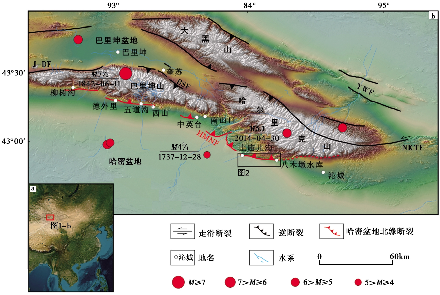
Fig. 1 Regional fault distribution map(modified from REN Guang-xue, 2021).
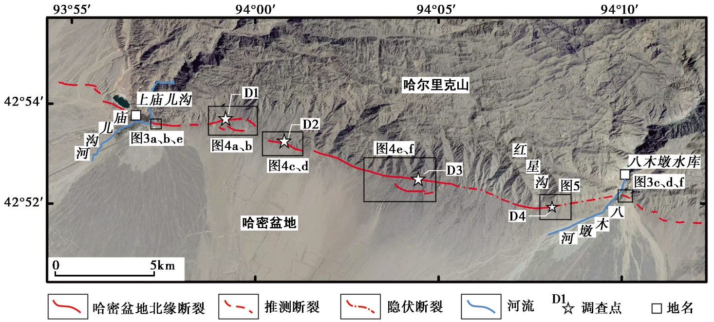
Fig. 2 Fault distribution map of the study area.
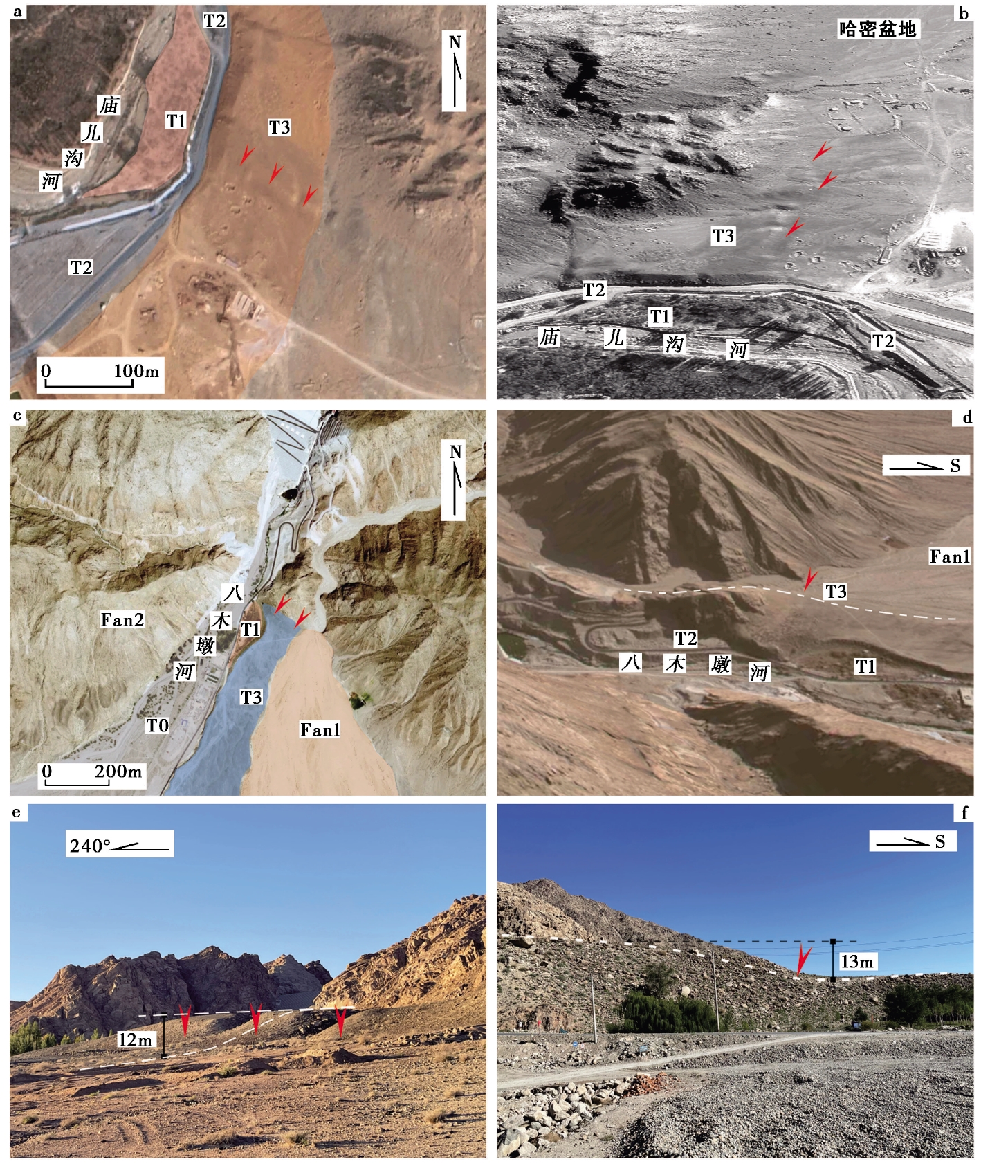
Fig. 3 Offsets of the terraces along the Miao'ergou and Bamudun Rivers.
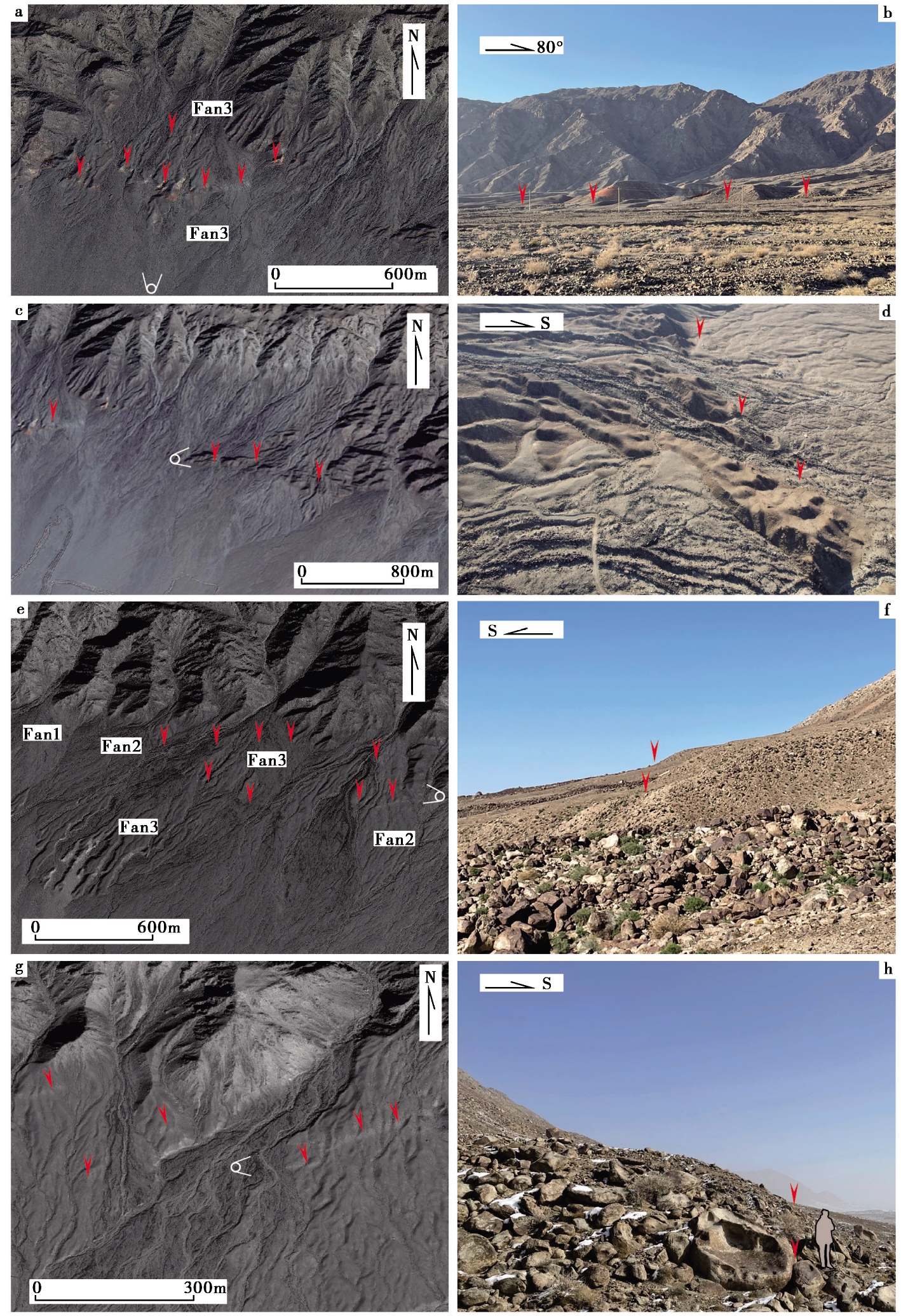
Fig. 4 Images and photographs of fault scarps on the alluvial fan.
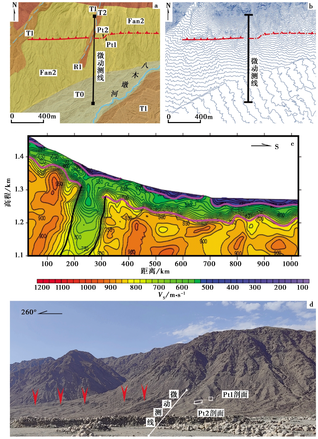
Fig. 5 Microtremor profile and trench location map.
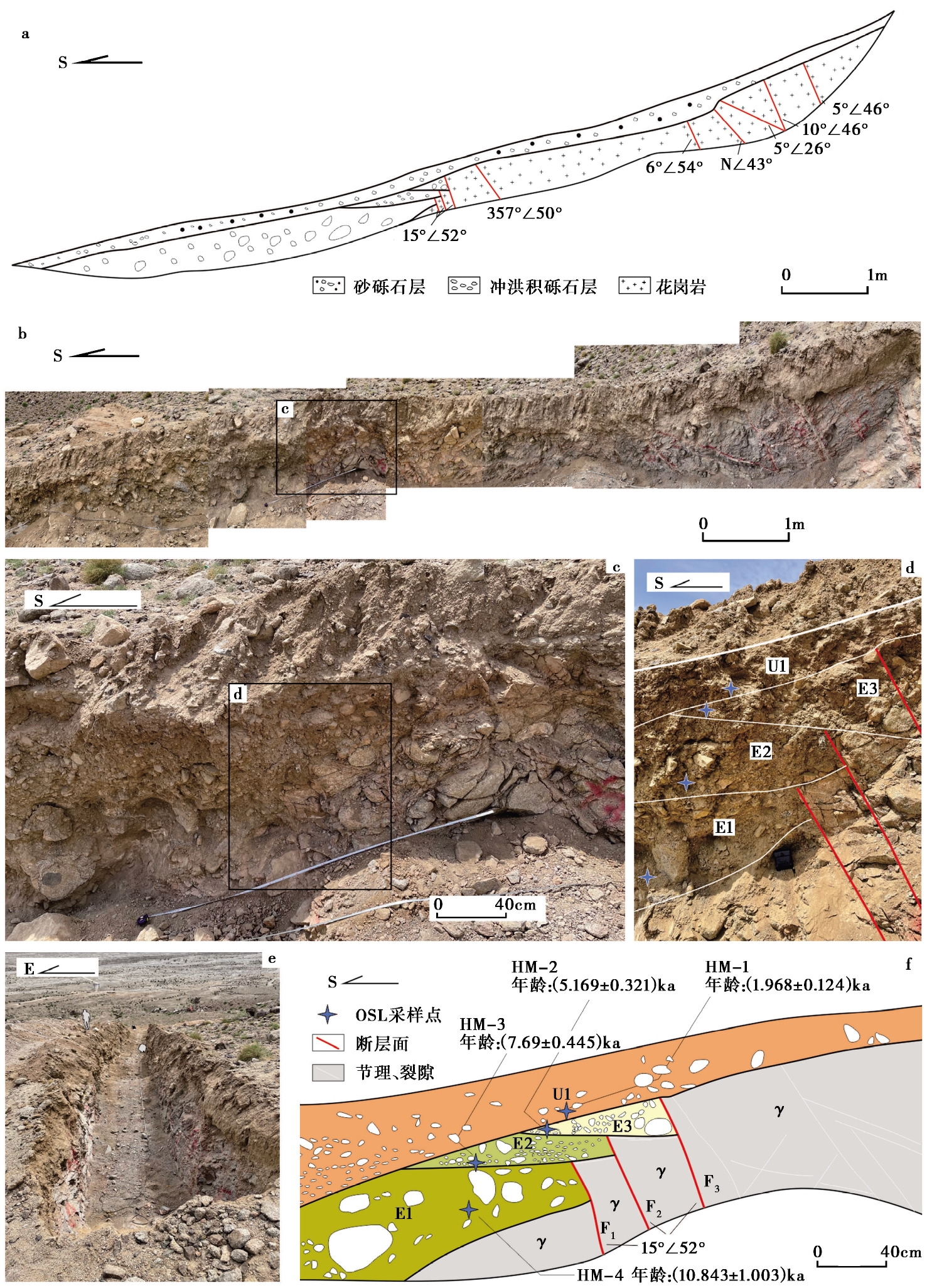
Fig. 6 Profile map and detail photographs of trench Pt1.
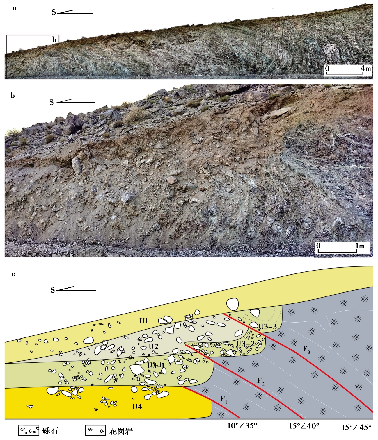
Fig. 7 Photos and profile of the fault outcrop at the adit portal(Pt2).
| 样品号 | 测试矿物 | U/ppm | Th/ppm | K/ppm | 含水量 /% | 埋深 /m | 环境剂量 /Gy·ka-1 | 等效剂量De /Gy | 年龄 /ka |
|---|---|---|---|---|---|---|---|---|---|
| HM-1 | 石英 | 6.79362 | 17.0734 | 2.41 | 0.427 | 0.3 | 6.99±0.417 | 13.756±0.283 | 1.968±0.124 |
| HM-2 | 石英 | 6.60067 | 19.25079 | 2.7467 | 0.0107 | 0.5 | 7.573±0.429 | 39.142±0.991 | 5.169±0.321 |
| HM-3 | 石英 | 6.1721 | 20.69530 | 2.57 | 0.0067 | 0.8 | 7.358±0.407 | 56.586±0.970 | 7.69±0.445 |
| HM-4 | 石英 | 6.4861 | 13.09402 | 1.60913 | 0.597 | 1.3 | 5.615±0.37 | 60.880±3.950 | 10.843±1.003 |
Table1 The dating results of OSL samples in Pt1 trench
| 样品号 | 测试矿物 | U/ppm | Th/ppm | K/ppm | 含水量 /% | 埋深 /m | 环境剂量 /Gy·ka-1 | 等效剂量De /Gy | 年龄 /ka |
|---|---|---|---|---|---|---|---|---|---|
| HM-1 | 石英 | 6.79362 | 17.0734 | 2.41 | 0.427 | 0.3 | 6.99±0.417 | 13.756±0.283 | 1.968±0.124 |
| HM-2 | 石英 | 6.60067 | 19.25079 | 2.7467 | 0.0107 | 0.5 | 7.573±0.429 | 39.142±0.991 | 5.169±0.321 |
| HM-3 | 石英 | 6.1721 | 20.69530 | 2.57 | 0.0067 | 0.8 | 7.358±0.407 | 56.586±0.970 | 7.69±0.445 |
| HM-4 | 石英 | 6.4861 | 13.09402 | 1.60913 | 0.597 | 1.3 | 5.615±0.37 | 60.880±3.950 | 10.843±1.003 |
| [1] |
柏美祥, 罗福忠, 李军, 等. 1999. 哈密盆地北缘活动断裂带微地貌[J]. 内陆地震, 13(2): 162-168.
|
|
|
|
| [2] |
陈杰, 丁国瑜,
|
|
|
|
| [3] |
邓起东, 冯先岳, 张培震, 等. 2000. 天山活动构造[M]. 北京: 地震出版社.
|
|
|
|
| [4] |
邓起东, 张培震, 冉勇康, 等. 2002. 中国活动构造基本特征[J]. 中国科学(D辑), 32(12): 1020-1030.
|
|
|
|
| [5] |
邓起东, 张培震, 冉勇康, 等. 2003. 中国活动构造与地震活动[J]. 地学前缘, 10(S1): 66-73.
|
|
|
|
| [6] |
黄帅堂, 胡伟华, 杨攀新, 等. 2020. 东天山唐巴勒-塔斯墩断裂带晚第四纪活动特征[J]. 地震地质, 42(5): 1058-1071. doi: 10.3969/j.issn.0253-4967.2020.05.003.
|
|
|
|
| [7] |
赖忠平, 欧先交. 2013. 光释光测年基本流程[J]. 地理科学进展, 32(5): 683-693.
|
|
|
|
| [8] |
李安, 冉勇康, 刘华国, 等. 2016. 西南天山柯坪推覆系西段全新世构造活动特征和古地震[J]. 地球科学进展, 31(4): 377-390.
|
|
|
|
| [9] |
倪红玉, 张若晗, 李俊伦, 等. 2023. 地震背景噪声HVSR方法在安徽明光城市场地响应特征和活断层探测中的应用[J]. 地球物理学报, 66(11): 4552-4571.
|
|
|
|
| [10] |
任光雪. 2021. 东天山左旋走滑断裂晚第四纪活动与构造转换[D]. 北京: 中国地震局地质研究所.
|
|
|
|
| [11] |
任光雪, 李传友, 孙凯. 2022. 天山东端喀尔里克山北缘断裂晚第四纪活动与转换挤压变形[J]. 地震地质, 44(1): 46-62. doi: 10.3969/j.issn.0253-4967.2022.01.004.
|
|
|
|
| [12] |
任光雪, 李传友, 吴传勇, 等. 2019. 东天山包尔图断裂带晚第四纪运动性质及形成机制[J]. 地震地质, 41(4): 856-871. doi: 10.3969/j.issn.0253-4967.2019.04.004.
|
|
|
|
| [13] |
沈军, 李莹甄, 汪一鹏, 等. 2003a. 阿尔泰山活动断裂[J]. 地学前缘, 10(S1): 132-141.
|
|
|
|
| [14] |
沈军, 汪一鹏, 李莹甄, 等. 2003b. 中国新疆天山博阿断裂晚第四纪右旋走滑运动特征[J]. 地震地质, 25(2): 183-194, 349.
|
|
|
|
| [15] |
王昌盛, 陈杰, 张克旗. 2005. 西南天山明尧勒背斜河流阶地沉积物的光释光测年[J]. 地震地质, 27(4): 586-598.
|
|
|
|
| [16] |
吴传勇, 阿里木江, 戴训也, 等. 2014. 西南天山迈丹断裂东段晚第四纪活动的发现及构造意义[J]. 地震地质, 36(4): 976-990. doi: 10.3969/j.issn.0253-4967.2014.04.004.
|
|
|
|
| [17] |
吴富峣. 2016. 东天山东段几条主要断裂晚第四纪活动证据与变形机制[D]. 北京: 中国地震局地质研究所.
|
|
|
|
| [18] |
徐新忠, 王有学, 蒋亚明, 等. 1992. 新-甘地震测深剖面的地壳速度结构及大地构造单元划分[J]. 新疆地质, 10(2): 147-154.
|
|
|
|
| [19] |
杨会丽. 2013. 地震相关快速沉积物释光测年研究[D]. 北京: 中国地震局地质研究所.
|
|
|
|
| [20] |
杨晓平, 邓起东, 张培震, 等. 2008. 天山山前主要推覆构造区的地壳缩短[J]. 地震地质, 30(1): 111-131.
|
|
|
|
| [21] |
张克旗, 吴中海, 吕同艳, 等. 2015. 光释光测年法: 综述及进展[J]. 地质通报, 34(1): 183-203.
|
|
|
|
| [22] |
张培震, 邓起东, 杨晓平, 等. 1996. 天山的晚新生代构造变形及其地球动力学问题[J]. 中国地震, 12(2): 127-140.
|
|
|
|
| [23] |
张培震, 邓起东, 张竹琪, 等. 2013. 中国大陆的活动断裂、 地震灾害及其动力过程[J]. 中国科学(地球科学), 43(10): 1607-1620.
|
|
|
|
| [24] |
|
| [25] |
|
| [26] |
|
| [27] |
|
| [28] |
DOI URL |
| [29] |
|
| [30] |
DOI URL |
| [31] |
|
| [1] | WANG Lei, REN Zhi-kun, WU Hong-bin, WANG Zhi-cai, ZHU Xiao-xiao, FU Jun-dong, JI Hao, XUE Jun-zhao, LEI Zhao-wei, WANG Ji-qiang. THE LATE QUATERNARY ACTIVITY CHARACTERISTICS OF THE MIDDLE-NORTHERN SECTION OF THE SHANGWUJING FAULT IN THE LUXI BLOCK [J]. SEISMOLOGY AND GEOLOGY, 2026, 48(1): 1-18. |
| [2] | PENG Fei, WANG Wei-jun, XIONG Ren-wei, LÜ Xiao-jian, YAN Kun, SUN Xin-zhe, GENG Shuang, KOU Hua-dong. DETECTION OF SHALLOW SEDIMENTARY STRUCTURE IN SIYANG, JIANGSU PROVINCE BY MICROTREMOR H/V SPECTRAL RATIO METHOD [J]. SEISMOLOGY AND GEOLOGY, 2022, 44(3): 561-577. |
| [3] | WANG Ji-xin, RONG Mian-shui, FU Li-yun, FU Lei. JOINT INVERSION OF SITE VELOCITY STRUCTURE BY MICRO-TREMOR ARRAY RECORD: A CASE STUDY OF THE OBSER-VATION SITE 3# OF XIANGTANG IN TANGSHAN [J]. SEISMOLOGY AND GEOLOGY, 2020, 42(6): 1335-1353. |
| Viewed | ||||||
|
Full text |
|
|||||
|
Abstract |
|
|||||
Copyright © SEISMOLOGY AND GEOLOGY, All Rights Reserved.
Tel: 010-62009049/9063 E-mail: dzdz@ies.ac.cn
Powered by Beijing Magtech Co., Ltd.