
SEISMOLOGY AND GEOLOGY ›› 2026, Vol. 48 ›› Issue (2): 475-496.DOI: 10.3969/j.issn.0253-4967.20250142
Previous Articles Next Articles
AEROMAGNETIC INTERPRETATION OF BURIED FAULT SPATIAL DISTRIBUTION CHARACTERISTICS IN THE NORTH CHINA BASIN
FAN Ji-di( ), WANG Xin*(), XIANG Jian-bin
National Institute of Natural Hazards ,MEMC
-
Received:2025-08-04Revised:2026-01-07Online:2026-04-20Published:2026-05-14
基于航磁场解译华北盆地隐伏断裂空间展布特征
樊继迪(), 王鑫*(), 向健斌
应急管理部国家自然灾害防治研究院
-
通讯作者:* 王鑫, 男, 1986年生, 副研究员, 主要从事重磁学与深部结构研究, E-mail: wangxindzdz@163.com。 -
作者简介:樊继迪, 女, 1998年生, 现为应急管理部国家自然灾害防治研究院在读硕士研究生, 主要从事航磁技术地质构造研究, E-mail: fjd1213@163.com。 -
基金资助:地球深部探测与矿产资源勘查国家科技重大专项课题(2024ZD1000707); 国家重点研发计划项目(2024YFC3012903); 中国地震局地壳应力研究所基本科研业务专项(ZDJ2019-05)
Cite this article
FAN Ji-di, WANG Xin, XIANG Jian-bin. AEROMAGNETIC INTERPRETATION OF BURIED FAULT SPATIAL DISTRIBUTION CHARACTERISTICS IN THE NORTH CHINA BASIN[J]. SEISMOLOGY AND GEOLOGY, 2026, 48(2): 475-496.
樊继迪, 王鑫, 向健斌. 基于航磁场解译华北盆地隐伏断裂空间展布特征[J]. 地震地质, 2026, 48(2): 475-496.
share this article
Add to citation manager EndNote|Ris|BibTeX
URL: https://www.dzdz.ac.cn/EN/10.3969/j.issn.0253-4967.20250142
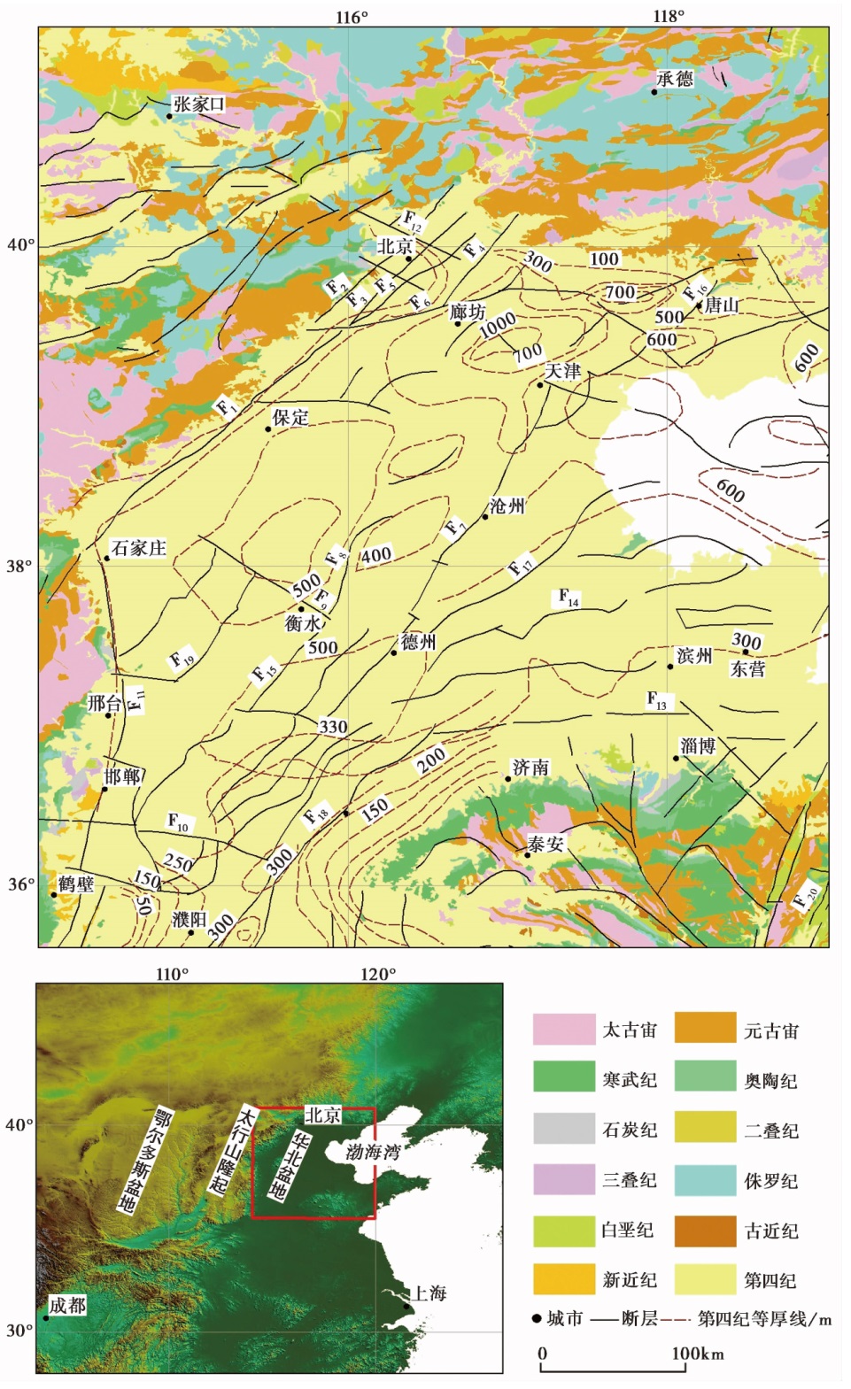
Fig. 1 Geological structure Map of North China.

Fig. 2 Original aeromagnetic field(ΔT) and reduction to the pole of the aeromagnetic anomaly field in the North China Basin.
| 纬度 | 类别 | 经度 | |||||
|---|---|---|---|---|---|---|---|
| 114°E | 115°E | 116°E | 117°E | 118°E | 119°E | ||
| 36°N | 磁倾角 | 54.9900° | 54.8573° | 54.7158° | 54.5655° | 54.4067° | 54.2397° |
| 磁偏角 | -5.9320° | -6.2106° | -6.4801° | -6.7392° | -6.9868° | -7.2214° | |
| 37°N | 磁倾角 | 56.2351° | 56.1012° | 55.9587° | 55.8076° | 55.6483° | 55.4809° |
| 磁偏角 | -6.1457° | -6.4327° | -6.7101° | -6.9767° | -7.2311° | -7.4721° | |
| 38°N | 磁倾角 | 57.4453° | 57.3104° | 57.167° | 57.0153° | 56.8555° | 56.6878° |
| 磁偏角 | -6.3620° | -6.6574° | -6.9427° | -7.2166° | -7.4778° | -7.7251° | |
| 39°N | 磁倾角 | 58.6220° | 58.4861° | 58.342° | 58.1897° | 58.0295° | 57.8618° |
| 磁偏角 | -6.5807° | -6.8846° | -7.1778° | -7.459° | -7.727° | -7.9805° | |
| 40°N | 磁倾角 | 59.7664° | 59.6297° | 59.4849° | 59.3321° | 59.1717° | 59.0039° |
| 磁偏角 | -6.8019° | -7.1143° | -7.4154° | -7.7038° | -7.9785° | -8.2382° | |
| 41°N | 磁倾角 | 60.8796° | 60.7422° | 60.5969° | 60.4438° | 60.2832° | 60.1155° |
| 磁偏角 | -7.0257° | -7.3465° | -7.6554° | -7.9511° | -8.2324° | -8.4982° | |
Table 1 Magnetic inclination and magnetic declination in variable-latitude reduction to the pole
| 纬度 | 类别 | 经度 | |||||
|---|---|---|---|---|---|---|---|
| 114°E | 115°E | 116°E | 117°E | 118°E | 119°E | ||
| 36°N | 磁倾角 | 54.9900° | 54.8573° | 54.7158° | 54.5655° | 54.4067° | 54.2397° |
| 磁偏角 | -5.9320° | -6.2106° | -6.4801° | -6.7392° | -6.9868° | -7.2214° | |
| 37°N | 磁倾角 | 56.2351° | 56.1012° | 55.9587° | 55.8076° | 55.6483° | 55.4809° |
| 磁偏角 | -6.1457° | -6.4327° | -6.7101° | -6.9767° | -7.2311° | -7.4721° | |
| 38°N | 磁倾角 | 57.4453° | 57.3104° | 57.167° | 57.0153° | 56.8555° | 56.6878° |
| 磁偏角 | -6.3620° | -6.6574° | -6.9427° | -7.2166° | -7.4778° | -7.7251° | |
| 39°N | 磁倾角 | 58.6220° | 58.4861° | 58.342° | 58.1897° | 58.0295° | 57.8618° |
| 磁偏角 | -6.5807° | -6.8846° | -7.1778° | -7.459° | -7.727° | -7.9805° | |
| 40°N | 磁倾角 | 59.7664° | 59.6297° | 59.4849° | 59.3321° | 59.1717° | 59.0039° |
| 磁偏角 | -6.8019° | -7.1143° | -7.4154° | -7.7038° | -7.9785° | -8.2382° | |
| 41°N | 磁倾角 | 60.8796° | 60.7422° | 60.5969° | 60.4438° | 60.2832° | 60.1155° |
| 磁偏角 | -7.0257° | -7.3465° | -7.6554° | -7.9511° | -8.2324° | -8.4982° | |

Fig. 3 Vertical first-order derivative field and oblique derivative field of the aeromagnetic field.
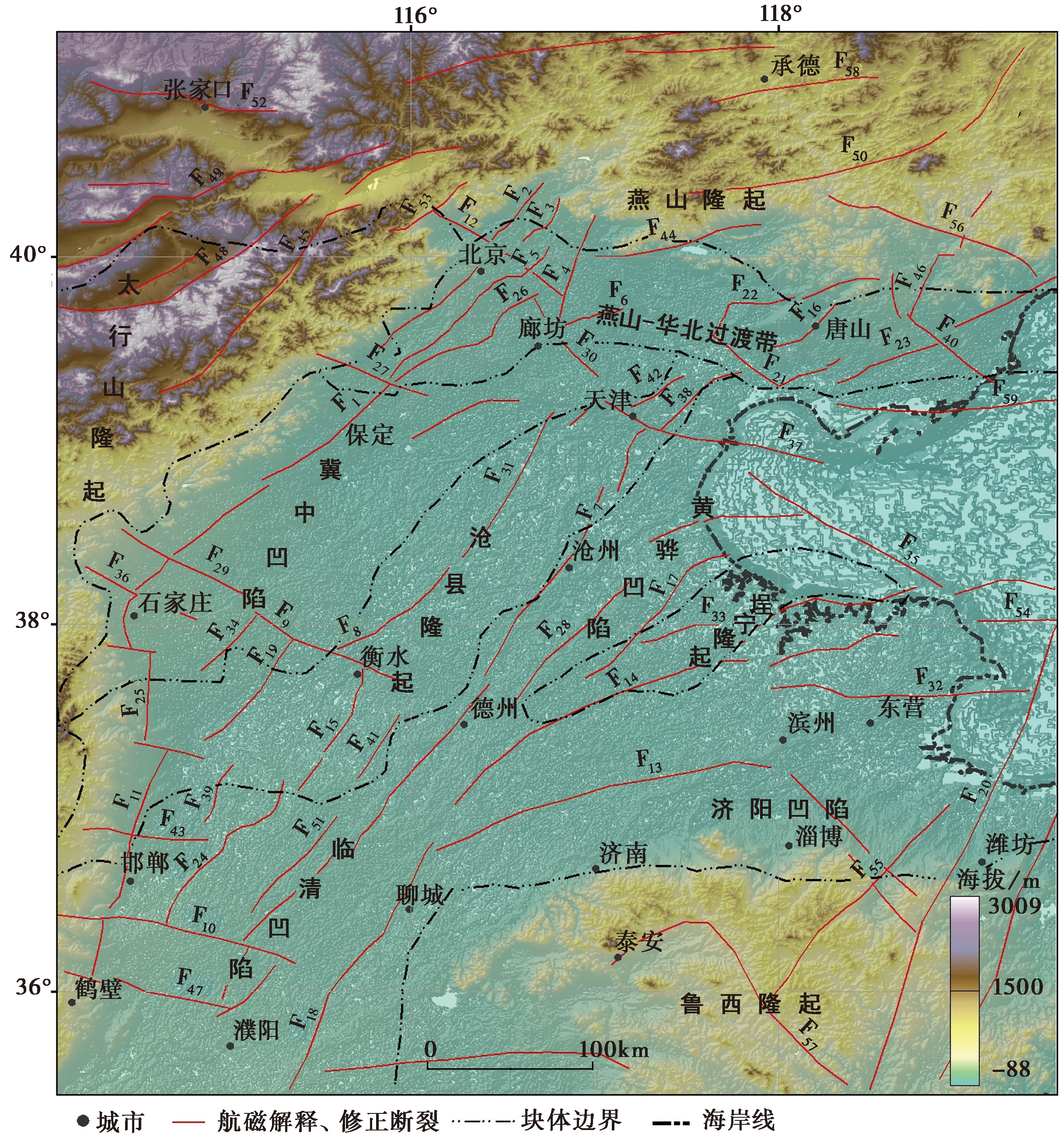
Fig. 4 Interpretation of the structural units and the faults in the North China Basin.
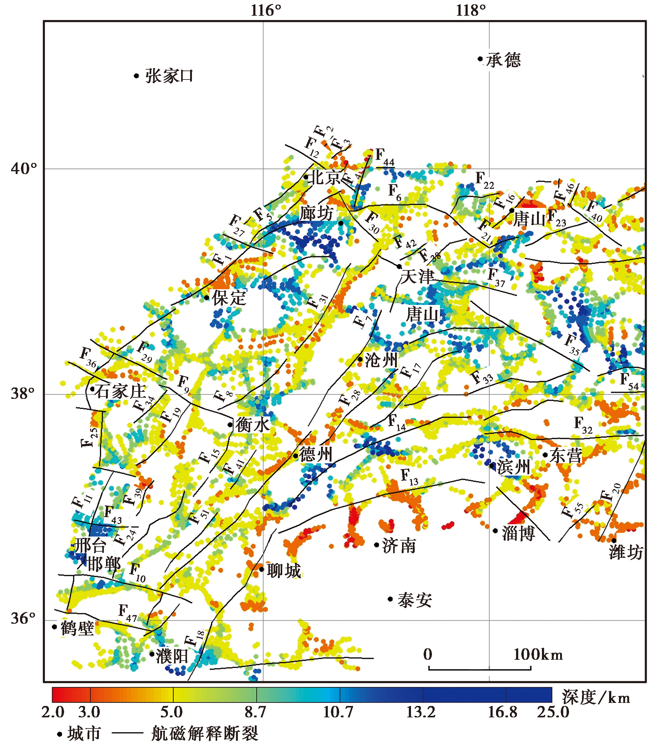
Fig. 5 Euler deconvolution and fault distribution.
| 断层名称 | 欧拉视深度 /km | 本文推测 下切规模 | 参考文献 | 前人结果 /km |
|---|---|---|---|---|
| 保定-石家庄断裂 (F1) | 北段4~7 | 中上地壳 | 地震探测地质解释剖面(徐杰等, | 5~10 |
| 中段5~10 | 深震反射(Deng et al., | 5.1 | ||
| 南段6~9 | 地震测深剖面(赵金仁等, | 7.8~8.2 | ||
| 黄庄-高丽营断裂 (F2) | 6~10 | 上地壳 | 重力剖面(张明辉等, | 10 |
| 二维地壳速度结构剖面(王帅军等, | 8~10 | |||
| 深地震反射剖面(刘保金等, | 8~9 | |||
| 深地震反射剖面(赵成彬等, | 4~8.3 | |||
| 顺义-良乡断裂 (F3) | 12~16 | 中下地壳 | 深地震反射剖面(刘保金等, | 5.5~6.0 |
| 深地震反射剖面(赵成彬等, | 4.8~5 | |||
| 深地震反射剖面(刘保金等, | 8~9 | |||
| 夏垫断裂 (F4) | 8~14 | 中下地壳 | 二维地壳速度结构剖面(王帅军等, | 12~14 |
| 深震反射剖面(刘保金等, | 20~21 | |||
| 深地震反射剖面(赵成彬等, | 16~18 | |||
| 宝坻断裂 (F6) | 7~9 | 上地壳 | 二维地壳速度结构剖面(王帅军等, | 10~11 |
| 深震反射剖面(赵金仁等, | 5.3~6 | |||
| 重力剖面(张明辉等, | 9~12 | |||
| 沧东断裂 (F7) | 6~9 | 上地壳 | 人工地震及地质解释剖面(高战武等, | 2~10 |
| 深地震反射剖面(中国地震局地球物理研究所 | 10~12 | |||
| 深震反射剖面(秦晶晶等, | 15.4~18 | |||
| 深震反射剖面(秦晶晶等, | 13.3~18.3 | |||
| 沧西断裂(F8) | 6~10 | 上地壳 | 深震反射剖面(秦晶晶等, | 13.3~19.3 |
| 邯郸断裂(F11) | 12~16 | 中下地壳 | 纵波速度结构剖面(周俊杰等, | 15~18 |
| 南口-孙河断裂(F12) | 6~10 | 上地壳 | 综合物探剖面(张磊等, | 上地壳 |
| 唐山断裂(F16) | 8~16 | 中下地壳 | 电性结构剖面(吴萍萍等, | 30~35 |
| 重力剖面(Jiang et al., | 18~20 | |||
| 埕西-羊二庄断裂(F17) | 8~12 | 中上地壳 | 深震反射剖面(秦晶晶等, | 15~15.4 |
| 聊城-兰考断裂(F18) | 6~12 | 上地壳 | 地震测深剖面(赵金仁等, | 7~10 |
| 深地震反射剖面(徐翰, | 20.7~22.1 | |||
| 蓟运河断裂(F21) | 8~11 | 中下地壳 | 深震反射剖面(闫成国等, | 8~9 |
| 人工地震剖面(张文朋等, | 上地壳 |
Table 2 Comparison of Euler’s apparent depth of major faults in the North China Basin with previous exploration results
| 断层名称 | 欧拉视深度 /km | 本文推测 下切规模 | 参考文献 | 前人结果 /km |
|---|---|---|---|---|
| 保定-石家庄断裂 (F1) | 北段4~7 | 中上地壳 | 地震探测地质解释剖面(徐杰等, | 5~10 |
| 中段5~10 | 深震反射(Deng et al., | 5.1 | ||
| 南段6~9 | 地震测深剖面(赵金仁等, | 7.8~8.2 | ||
| 黄庄-高丽营断裂 (F2) | 6~10 | 上地壳 | 重力剖面(张明辉等, | 10 |
| 二维地壳速度结构剖面(王帅军等, | 8~10 | |||
| 深地震反射剖面(刘保金等, | 8~9 | |||
| 深地震反射剖面(赵成彬等, | 4~8.3 | |||
| 顺义-良乡断裂 (F3) | 12~16 | 中下地壳 | 深地震反射剖面(刘保金等, | 5.5~6.0 |
| 深地震反射剖面(赵成彬等, | 4.8~5 | |||
| 深地震反射剖面(刘保金等, | 8~9 | |||
| 夏垫断裂 (F4) | 8~14 | 中下地壳 | 二维地壳速度结构剖面(王帅军等, | 12~14 |
| 深震反射剖面(刘保金等, | 20~21 | |||
| 深地震反射剖面(赵成彬等, | 16~18 | |||
| 宝坻断裂 (F6) | 7~9 | 上地壳 | 二维地壳速度结构剖面(王帅军等, | 10~11 |
| 深震反射剖面(赵金仁等, | 5.3~6 | |||
| 重力剖面(张明辉等, | 9~12 | |||
| 沧东断裂 (F7) | 6~9 | 上地壳 | 人工地震及地质解释剖面(高战武等, | 2~10 |
| 深地震反射剖面(中国地震局地球物理研究所 | 10~12 | |||
| 深震反射剖面(秦晶晶等, | 15.4~18 | |||
| 深震反射剖面(秦晶晶等, | 13.3~18.3 | |||
| 沧西断裂(F8) | 6~10 | 上地壳 | 深震反射剖面(秦晶晶等, | 13.3~19.3 |
| 邯郸断裂(F11) | 12~16 | 中下地壳 | 纵波速度结构剖面(周俊杰等, | 15~18 |
| 南口-孙河断裂(F12) | 6~10 | 上地壳 | 综合物探剖面(张磊等, | 上地壳 |
| 唐山断裂(F16) | 8~16 | 中下地壳 | 电性结构剖面(吴萍萍等, | 30~35 |
| 重力剖面(Jiang et al., | 18~20 | |||
| 埕西-羊二庄断裂(F17) | 8~12 | 中上地壳 | 深震反射剖面(秦晶晶等, | 15~15.4 |
| 聊城-兰考断裂(F18) | 6~12 | 上地壳 | 地震测深剖面(赵金仁等, | 7~10 |
| 深地震反射剖面(徐翰, | 20.7~22.1 | |||
| 蓟运河断裂(F21) | 8~11 | 中下地壳 | 深震反射剖面(闫成国等, | 8~9 |
| 人工地震剖面(张文朋等, | 上地壳 |
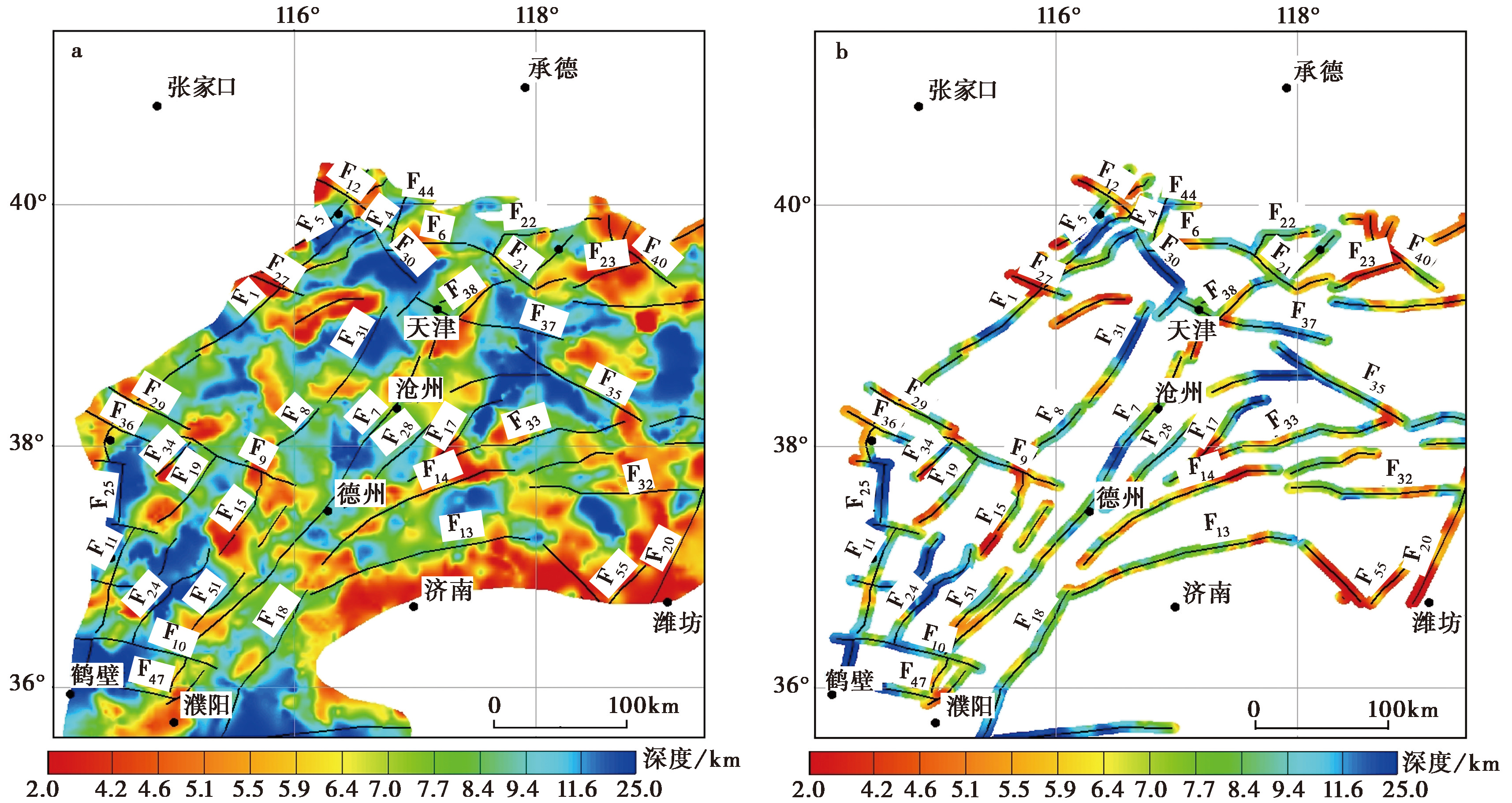
Fig. 6 Plan view of Euler visual depth interpolation for faults.
| [1] |
陈青, 袁炳强, 董云鹏, 等. 2013. 断裂识别新方法及其在肯尼亚Tana凹陷中的应用[J]. 西北大学学报(自然科学版), 43(4): 599—605.
|
|
|
|
| [2] |
邓起东, 张培震, 冉勇康, 等. 2003. 中国活动构造与地震活动[J]. 地学前缘, 10(U08): 66—73.
|
|
|
|
| [3] |
段吉业, 刘鹏举, 夏德馨. 2002. 浅析华北板块中元古代—古生代构造格局及其演化[J]. 现代地质, 16(4): 331—338.
|
|
|
|
| [4] |
范美宁. 2006. 欧拉反褶积方法的研究与应用[D]. 长春: 吉林大学.
|
|
|
|
| [5] |
方菲. 2020. 根据重磁资料解释河北断裂体系与地震地质构造[J]. 物探与化探, 44(3): 489—498.
|
|
|
|
| [6] |
高战武, 徐杰, 宋长青, 等. 2000. 华北沧东断裂的构造特征[J]. 地震地质, 22(4): 395—404.
|
|
|
|
| [7] |
管志宁. 2005. 地磁场与磁力勘探[M]. 北京: 地质出版社.
|
|
|
|
| [8] |
嘉世旭, 张成科, 赵金仁, 等. 2009. 华北东北部裂陷盆地与燕山隆起地壳结构[J]. 地球物理学报, 52(1): 99—110.
|
|
|
|
| [9] |
嘉世旭, 张先康. 2005. 华北不同构造块体地壳结构及其对比研究[J]. 地球物理学报, 48(3): 611—620.
|
|
|
|
| [10] |
焦立果, 雷宇, 涂继耀, 等. 2022. 航磁异常分析技术及其在地质构造中的应用[J]. 地球与行星物理论评, 53(3): 331—358.
|
|
|
|
| [11] |
刘保金, 胡平, 孟勇奇, 等. 2009. 北京地区地壳精细结构的深地震反射剖面探测研究[J]. 地球物理学报, 52(9): 2264—2272.
|
|
|
|
| [12] |
刘保金, 张先康, 陈颙, 等. 2011. 三河-平谷8.0级地震区地壳结构和活动断裂研究: 利用单次覆盖深反射和浅层地震剖面[J]. 地球物理学报, 54(5): 1251—1259.
|
|
|
|
| [13] |
刘芳, 祝意青, 梁伟锋, 等. 2016. 基于欧拉反褶积方法估算华北地区重力变化的等效源参数[J]. 地震, 36(4): 163—170.
|
|
|
|
| [14] |
刘国栋, 刘昌铨. 1982. 华北北部地区地壳上地幔构造及其与新生代构造活动的关系[J]. 中国科学(B辑), 12(12): 1132—1140.
|
|
|
|
| [15] |
倪志耀, 翟明国, 王仁民, 等. 2004. 华北古陆块北缘中段发现晚古生代退变榴辉岩[J]. 科学通报, 49(6): 585—591.
|
|
|
|
| [16] |
戚帮申, 潘智锋, 丰成君, 等. 2020. 北京顺义断裂第四纪活动性地球物理及钻孔综合探测证据[J]. 地质学报, 94(4): 1315—1329.
|
|
|
|
| [17] |
秦晶晶, 刘保金, 酆少英, 等. 2024. 深地震反射剖面揭示沧县隆起和黄骅坳陷及邻区的地壳精细结构和构造特征[J]. 地震地质, 46(3): 608—626. doi: 10.3969/j.issn.0253-4967.2024.03.006.
|
|
|
|
| [18] |
邵时雄, 安仲元, 韩书华. 1984. 河北平原新构造运动主要特征的分析[J]. 海洋地质与第四纪地质, 4(4): 67—77.
|
|
|
|
| [19] |
王帅军, 张先康, 张成科, 等. 2007. 武清—北京—赤城二维地壳结构和构造[J]. 地球物理学报, 50(6): 1769—1777.
|
|
|
|
| [20] |
吴萍萍, 丁志峰, 谭捍东, 等. 2021. 基于VP/VS波速比模型约束的张渤地震带深部电性结构研究[J]. 地球物理学报, 64(8): 2716—2732.
|
|
|
|
| [21] |
向宏发, 方仲景, 徐杰, 等. 1988. 三河-平谷8级地震区的构造背景与大震重复性研究[J]. 地震地质, 10(1): 15—28.
|
|
|
|
| [22] |
向宏发, 王学潮, 虢顺民, 等. 2000. 聊城-兰考隐伏断裂第四纪活动性的综合探测研究[J]. 地震地质, 22(4): 351—359.
|
|
|
|
| [23] |
熊盛青, 杨海, 丁燕云, 等. 2018. 中国航磁大地构造单元划分[J]. 中国地质, 45(4): 658—680.
|
|
|
|
| [24] |
徐翰. 2018. 渤海湾盆地东濮凹陷形成与演化的数值模拟与构造分析[D]. 北京: 中国地质大学.
|
|
|
|
| [25] |
徐剑春, 李文勇, 刘燕戌. 2016. 欧拉反褶积法在航空重力勘探中的应用[J]. 地球物理学进展, 31(1): 390—395.
|
|
|
|
| [26] |
徐杰, 高战武, 宋长青, 等. 2000. 太行山山前断裂带的构造特征[J]. 地震地质, 22(2): 111—122.
|
|
|
|
| [27] |
徐志萍, 方盛明, 李德庆, 等. 2017. 利用布格重力资料研究华北裂陷盆地地壳结构特征[J]. 大地测量与地球动力学, 37(3): 246—250.
|
|
|
|
| [28] |
闫成国, 曹井泉, 陈宇坤, 等. 2020. 深地震反射剖面揭示的天津地区张渤带地壳精细结构[J]. 地球物理学报, 63(12): 4431—4439.
|
|
|
|
| [29] |
余和中, 吕福亮, 郭庆新, 等. 2005. 华北板块南缘原型沉积盆地类型与构造演化[J]. 石油实验地质, 27(2): 111—117.
|
|
|
|
| [30] |
张春灌, 袁炳强, 李玉宏. 2019. 吐鲁番中南部地区航磁异常特征及其地质意义[J]. 地球物理学进展, 34(5): 1811—1817.
|
|
|
|
| [31] |
张欢, 徐康, 王慧, 等. 2021. 华北盆地北缘宝坻断裂晚更新世以来的活动性研究[J]. 大地测量与地球动力学, 41(11): 1169—1176, 1188.
|
|
|
|
| [32] |
张磊, 白凌燕, 蔡向民, 等. 2014. 北京南口-孙河断裂北西段综合物探剖面定位及其活动性研究[J]. 现代地质, 28(1): 234—242.
|
|
|
|
| [33] |
张蕾, 李海兵, 孙知明, 等. 2019. 断裂岩岩石磁学研究进展[J]. 地球学报, 40(1): 157—172.
|
|
|
|
| [34] |
张明辉, 申重阳, 杨光亮, 等. 2025. 三河-平谷8级震区地壳三维密度结构反演研究[J]. 地球物理学报, 68(3): 882—897.
|
|
|
|
| [35] |
张文朋, 张春丽, 高武平, 等. 2022. 用浅层地震勘探资料研究蓟运河断裂的第四纪活动特征[J]. 地震工程学报, 44(1): 183—191.
|
|
|
|
| [36] |
赵成彬, 刘保金, 姬计法, 等. 2013. 北京南部地壳精细结构深地震反射探测研究[J]. 地球物理学报, 56(4): 1168—1176.
|
|
|
|
| [37] |
赵金仁, 刘保金, 段永红, 等. 2017. 利用爆破地震揭示华北克拉通基底的高分辨速度结构: 大丰—包头折射剖面的探测结果[J]. 地球物理学报, 60(7): 2628—2640.
|
|
|
|
| [38] |
赵金仁, 张先康, 张成科, 等. 2004. 利用宽角反射/折射和深反射探测剖面揭示三河-平谷大震区深部结构特征[J]. 地球物理学报, 47(4): 646—653.
|
|
|
|
| [39] |
周俊杰, 宋宏利, 刘海新, 等. 2012. 邯郸市周边断裂带的活动特征分析[J]. 地震地质, 34(1): 100—109.
|
|
|
|
| [40] |
|
| [41] |
|
| [42] |
|
| [43] |
|
| [44] |
|
| [45] |
|
| [46] |
|
| [47] |
DOI URL |
| [48] |
DOI URL |
| [49] |
DOI URL |
| [50] |
|
| [51] |
|
| [52] |
|
| [53] |
|
| [54] |
|
| [55] |
|
| [56] |
|
| [57] |
|
| [58] |
DOI URL |
| [59] |
DOI |
| [60] |
|
| [1] | FENG Shao-ying, LIU Bao-jin, ZUO Ying, JI Ji-fa, TAN Ya-li, DING Kui, WU Quan. THE STUDY OF FINE CRUSTAL STRUCTURE OF THE SOUTHERN MARGIN OF TAIHANG MOUNTAIN BY DEEP SEISMIC REFLECTION PROFILE [J]. SEISMOLOGY AND GEOLOGY, 2025, 47(1): 267-283. |
| [2] | ZHANG En-hui, SHI Ya-qin, ZHANG Yi, LI Miao, LI Gao-yang, PEI Gen-di, WANG Wan-he. EXTENSION AND STRUCTURAL FEATURE OF THE BURIED SEGMENT OF TAOCHUAN-HUXIAN FAULT IN THE WEIHE BASIN [J]. SEISMOLOGY AND EGOLOGY, 2021, 43(6): 1485-1506. |
| [3] | ZHENG Ying-ping, YANG Xiao-ping, SHU Peng, LU Shuo, FANG Liang-hao, SHI Jin-hu, HUANG Xiong-nan, LIU Chun-ru. STUDY ON THE LATEST ACTIVITY OF WUYUNSHAN-HEFEI FAULT IN HEFEI BASIN, THE WESTERN BRANCH OF THE TANLU FAULT ZONE [J]. SEISMOLOGY AND GEOLOGY, 2020, 42(1): 50-64. |
| [4] | ZHANG Long-sheng, ZHOU Ben-gang, JI Feng-ju, YANG Xiao-ping, AN Yan-fen. FAULT ACTIVITY OF THE SOUTHWESTERN SEGMENT OF THE EASTERN BRANCH OF XINYI-LIANJIANG FAULT ZONE IN GUANGDONG PROVINCE [J]. SEISMOLOGY AND GEOLOGY, 2016, 38(2): 316-328. |
| [5] | YU Yang, SHEN Jun, YU Xiao-hui, WU Xiao-ge. THE APPLICATION OF PETROLEUM SEISMIC DATA TO THE BURIED ACTIVE FAULT DETECTION——A CASE STUDY OF ACTIVE FAULTS SURVEYING IN SONGYUAN CITY [J]. SEISMOLOGY AND GEOLOGY, 2016, 38(2): 423-433. |
| [6] | LEI Qi-yun, CHAI Chi-zhang, DU Peng, YU Jing-xing, WANG Yin, XIE Xiao-feng. THE SEISMOGENIC STRUCTURE OF THE M8.0 PINGLUO EARTHQUAKE IN 1739 [J]. SEISMOLOGY AND GEOLOGY, 2015, 37(2): 413-429. |
| [7] | CAO Jun, RAN Yong-kang, XU Han-gang, LI Yan-bao, ZHANG Peng, MA Xing-quan, LI Li-mei. TYPICAL CASE ANALYSIS ON APPLICATION OF MULTI-METHOD DETECTION TECHNIQUE TO ACTIVE FAULT EXPLORATION IN SUQIAN CITY [J]. SEISMOLOGY AND GEOLOGY, 2015, 37(2): 430-439. |
| [8] | WANG Yin, MENG Guang-kui, CHAI Chi-zhang, LEI Qi-yun, DU Peng, XIE Xiao-feng. THE ACCURATE LOCATION METHODS FOR BURIED ACTIVE FAULT EXPLORATION: AN EXAMPLE OF LUHUATAI FAULTS IN YINCHUAN GRABEN [J]. SEISMOLOGY AND GEOLOGY, 2015, 37(1): 256-268. |
| [9] | YAN Cheng-guo, CHEN Yu-kun, GAO Wu-ping, YANG Fei. ACOUSTIC SURVEYING OF THE BURIED FAULTS IN TIANJIN QIKOU DEPRESSION [J]. SEISMOLOGY AND GEOLOGY, 2013, 35(4): 745-753. |
| [10] | GAO Jing-hua, XU Ming-cai. ANALYSIS OF INFLUENCING FACTORS IN DETERMINING THE UPPER OFFSET POINT OF ACTIVE FAULTS USING SEISMIC METHOD [J]. SEISMOLOGY AND GEOLOGY, 2012, (2): 338-347. |
| [11] | LI Le, CHEN Qi-fu. SLIP RATES AT DEPTH ALONG THE BURIED FAULTS IN BEIJING PLAIN AREA ETSTIMATED FROM REPEATING MICROEARTHQUAKES [J]. SEISMOLOGY AND GEOLOGY, 2010, 32(3): 508-519. |
| [12] | ZHANG Jian-guo, LIU Li-fang, LI Xi, XIE Ying-qing. PRELIMINARY STUDY ON THE SEISMOTECTONICS OF YAO'AN & DAYAO MODERATE STONG EARTHQUAKE AREA [J]. SEISMOLOGY AND GEOLOGY, 2009, 31(3): 536-543. |
| [13] | HE Zhong-tai, MA Bao-qi, LU Hai-feng, WANG Jin-yan. EVIDENCE OF THE DONGBEIWANG-XIAOTANGSHAN FAULT IN BEIJING [J]. SEISMOLOGY AND GEOLOGY, 2009, 31(2): 233-246. |
| [14] | ZHU Tao, FENG Rui, ZHOU Jian-guo, HAO Jin-qi, WANG Hua-lin, WANG Shuo-qing. THE METHOD FOR INFERRING A BURIED FAULT FROM RESISTIVITY TOMOGRAMS AND ITS TYPICAL ELECTRICAL FEATURES [J]. SEISMOLOGY AND GEOLOGY, 2009, 31(1): 34-43. |
| [15] | DONG Shao-peng, HAN Zhu-jun, YIN Jin-hui, LI Feng, AN Yan-fen. A PRELIMINARY RESEARCH ON THE LATEST TECTONIC DEFORMATION STYLE AND THE ACTIVITY AGE OF THE DAYI FAULT IN THE PIEDMONT OF THE LONGMEN MOUNTAINS [J]. SEISMOLOGY AND GEOLOGY, 2008, 30(4): 996-1003. |
| Viewed | ||||||
|
Full text |
|
|||||
|
Abstract |
|
|||||
Copyright © SEISMOLOGY AND GEOLOGY, All Rights Reserved.
Tel: 010-62009049/9063 E-mail: dzdz@ies.ac.cn
Powered by Beijing Magtech Co., Ltd.