
SEISMOLOGY AND GEOLOGY ›› 2026, Vol. 48 ›› Issue (4): 1138-1157.DOI: 10.3969/j.issn.0253-4967.20250046
• Research paper • Previous Articles Next Articles
THE INFLUENCE OF MS7.0 EARTHQUAKES OCCURRING WITHIN THE QINGHAI-XIZANG PLATEAU TECTONIC BLOCK ON SEIS-MIC ACTIVITIES IN THE SICHUAN-YUNNAN REGION: BASED ON THE ANALYSIS OF CO-SEISMIC STEP-CHANGING OF THE GROUNDWATER LEVELS
MIAO A-li1)( ), ZHOU Zhi-hua2),*(), HU Xiao-jing3), ZHANG Yi1), WANG Wei1), YANG Yun1), YANG Yao4), YE Bi-wen1), ZHU Tao1), YUAN Gui-ping1), WANG Kai1)
- 1)
Jiangsu Earthquake Agency
2)China Earthquake Networks Center
3)Yunnan Earthquake Agency
4)Sichuan Earthquake Agency
-
Received:2025-02-06Revised:2025-08-22Online:2026-08-20Published:2026-09-09
青藏高原构造块体7.0级地震对川滇地区地震活动的影响——基于地下流体井的水位同震阶变
缪阿丽1)(), 周志华2),*(), 胡小静3), 张艺1), 王维1), 杨云1), 杨耀4), 叶碧文1), 祝涛1), 袁桂平1), 王凯1)
- 1)
江苏省地震局
2)中国地震台网中心
3)云南省地震局
4)四川省地震局
-
通讯作者:* 周志华, 女, 1979年生, 正高级工程师, 主要从事地震前兆流体和地震预报等研究, E-mail: zhouzhihua@seis.ac.cn。 -
作者简介:缪阿丽, 女, 1984年生, 2011年于中国地震局地质研究所获固体地球物理学专业博士学位, 高级工程师, 主要从事地震地下流体分析与地震预报, E-mail: miaoali330@126.com。
-
基金资助:中国地震局地震预测开放基金(XH240100)

Cite this article
MIAO A-li, ZHOU Zhi-hua, HU Xiao-jing, ZHANG Yi, WANG Wei, YANG Yun, YANG Yao, YE Bi-wen, ZHU Tao, YUAN Gui-ping, WANG Kai. THE INFLUENCE OF MS7.0 EARTHQUAKES OCCURRING WITHIN THE QINGHAI-XIZANG PLATEAU TECTONIC BLOCK ON SEIS-MIC ACTIVITIES IN THE SICHUAN-YUNNAN REGION: BASED ON THE ANALYSIS OF CO-SEISMIC STEP-CHANGING OF THE GROUNDWATER LEVELS[J]. SEISMOLOGY AND GEOLOGY, 2026, 48(4): 1138-1157.
缪阿丽, 周志华, 胡小静, 张艺, 王维, 杨云, 杨耀, 叶碧文, 祝涛, 袁桂平, 王凯. 青藏高原构造块体7.0级地震对川滇地区地震活动的影响——基于地下流体井的水位同震阶变[J]. 地震地质, 2026, 48(4): 1138-1157.
share this article
Add to citation manager EndNote|Ris|BibTeX
URL: https://www.dzdz.ac.cn/EN/10.3969/j.issn.0253-4967.20250046
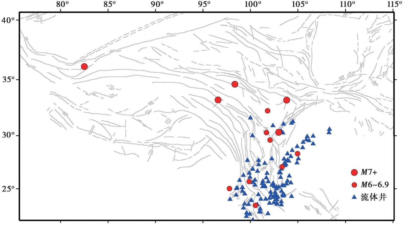
Fig. 1 The distribution of earthquake events with MS≥7.0 within the study region, observation wells and MS≥6.0 events within the Sichuan-Yunan region.
| 序号 | 发震日期 | 发震地点 | 经度 /(°) | 纬度 /(°) | 震级 /MS | 震源机制解 (走向/倾角/滑动角) |
|---|---|---|---|---|---|---|
| 1 | 2010-04-14 | 青海玉树 | 33.22 | 96.59 | 7.3 | 节面Ⅰ: 119°/83°/-2°,节面Ⅱ: 209°/88°/-173°(蒋海昆, |
| 2 | 2013-04-20 | 四川芦山 | 30.30 | 103.00 | 7.0 | 节面Ⅰ: 214°/39°/100°,节面Ⅱ: 21°/52°/82°(蒋海昆, |
| 3 | 2014-02-12 | 新疆于田 | 36.14 | 82.51 | 7.3 | 节面Ⅰ: 238°/81°/-22°,节面Ⅱ: 332°/68°/-171°(蒋海昆, |
| 4 | 2014-05-30 | 云南盈江 | 25.02 | 97.80 | 6.1 | 节面Ⅰ: 351°/65°/180°,节面Ⅱ: 261°/90°/-25°(蒋海昆, |
| 5 | 2014-08-03 | 云南鲁甸 | 27.11 | 103.33 | 6.5 | 节面Ⅰ: 70°/79°/155°,节面Ⅱ: 165°65°/12°(蒋海昆, |
| 6 | 2014-10-07 | 云南普洱 | 23.40 | 100.55 | 6.9 | 节面Ⅰ: 149°/78°/174°,节面Ⅱ: 240°/84°/12°(蒋海昆, |
| 7 | 2014-11-22 | 四川康定 | 30.29 | 101.68 | 6.4 | 节面Ⅰ: 143°/82°/-9°,节面Ⅱ: 234°/81°/-172°(蒋海昆, |
| 8 | 2017-08-08 | 四川九寨沟 | 33.20 | 103.82 | 7.0 | 节面Ⅰ: 144°/87°/-1°,节面Ⅱ: 234°/89°/-177°(周龙泉, |
| 9 | 2019-06-17 | 四川长宁 | 28.34 | 104.96 | 6.0 | 节面Ⅰ: 131°/51°/36°,节面Ⅱ: 16°/63°/135°(邵志刚, |
| 10 | 2021-05-21 | 云南漾濞 | 25.70 | 99.88 | 6.5 | 节面Ⅰ: 135°/80°/176°,节面Ⅱ: 226°/86°/10°(王莹等, |
| 11 | 2021-05-22 | 青海玛多 | 34.61 | 98.37 | 7.4 | 节面Ⅰ: 283°/59°/-4°,节面Ⅱ: 15°/86°/-149°(赵韬等, |
| 12 | 2022-06-01 | 四川芦山 | 30.37 | 102.94 | 6.1 | 节面Ⅰ: 228°/46°/106°,节面Ⅱ: 26°/46°/74°(许英才等, |
| 13 | 2022-06-10 | 四川马尔康 | 32.25 | 101.82 | 6.0 | 节面Ⅰ: 150°/79°/7°,节面Ⅱ: 59°/83°/169°(许英才等, |
| 14 | 2022-09-05 | 四川泸定 | 29.59 | 102.08 | 6.8 | 节面Ⅰ: 75°/90°/155°,节面Ⅱ: 165°/65°/0°(易桂喜等, |
Table1 Earthquake events with a magnitude of MS≥7.0 within the Qinghai-Xizang Plateau tectonic block and MS≥6.0 with the Sichuan-Yunan region since 2010
| 序号 | 发震日期 | 发震地点 | 经度 /(°) | 纬度 /(°) | 震级 /MS | 震源机制解 (走向/倾角/滑动角) |
|---|---|---|---|---|---|---|
| 1 | 2010-04-14 | 青海玉树 | 33.22 | 96.59 | 7.3 | 节面Ⅰ: 119°/83°/-2°,节面Ⅱ: 209°/88°/-173°(蒋海昆, |
| 2 | 2013-04-20 | 四川芦山 | 30.30 | 103.00 | 7.0 | 节面Ⅰ: 214°/39°/100°,节面Ⅱ: 21°/52°/82°(蒋海昆, |
| 3 | 2014-02-12 | 新疆于田 | 36.14 | 82.51 | 7.3 | 节面Ⅰ: 238°/81°/-22°,节面Ⅱ: 332°/68°/-171°(蒋海昆, |
| 4 | 2014-05-30 | 云南盈江 | 25.02 | 97.80 | 6.1 | 节面Ⅰ: 351°/65°/180°,节面Ⅱ: 261°/90°/-25°(蒋海昆, |
| 5 | 2014-08-03 | 云南鲁甸 | 27.11 | 103.33 | 6.5 | 节面Ⅰ: 70°/79°/155°,节面Ⅱ: 165°65°/12°(蒋海昆, |
| 6 | 2014-10-07 | 云南普洱 | 23.40 | 100.55 | 6.9 | 节面Ⅰ: 149°/78°/174°,节面Ⅱ: 240°/84°/12°(蒋海昆, |
| 7 | 2014-11-22 | 四川康定 | 30.29 | 101.68 | 6.4 | 节面Ⅰ: 143°/82°/-9°,节面Ⅱ: 234°/81°/-172°(蒋海昆, |
| 8 | 2017-08-08 | 四川九寨沟 | 33.20 | 103.82 | 7.0 | 节面Ⅰ: 144°/87°/-1°,节面Ⅱ: 234°/89°/-177°(周龙泉, |
| 9 | 2019-06-17 | 四川长宁 | 28.34 | 104.96 | 6.0 | 节面Ⅰ: 131°/51°/36°,节面Ⅱ: 16°/63°/135°(邵志刚, |
| 10 | 2021-05-21 | 云南漾濞 | 25.70 | 99.88 | 6.5 | 节面Ⅰ: 135°/80°/176°,节面Ⅱ: 226°/86°/10°(王莹等, |
| 11 | 2021-05-22 | 青海玛多 | 34.61 | 98.37 | 7.4 | 节面Ⅰ: 283°/59°/-4°,节面Ⅱ: 15°/86°/-149°(赵韬等, |
| 12 | 2022-06-01 | 四川芦山 | 30.37 | 102.94 | 6.1 | 节面Ⅰ: 228°/46°/106°,节面Ⅱ: 26°/46°/74°(许英才等, |
| 13 | 2022-06-10 | 四川马尔康 | 32.25 | 101.82 | 6.0 | 节面Ⅰ: 150°/79°/7°,节面Ⅱ: 59°/83°/169°(许英才等, |
| 14 | 2022-09-05 | 四川泸定 | 29.59 | 102.08 | 6.8 | 节面Ⅰ: 75°/90°/155°,节面Ⅱ: 165°/65°/0°(易桂喜等, |
| 测点 | 2021-05-22 青海玛多7.4级地震 | 2017-08-08 四川九寨沟7.0级地震 | 2013-04-20 四川芦山7.0级地震 | |||||||
|---|---|---|---|---|---|---|---|---|---|---|
| 同震 响应 形态 | 同震响应 持续时间 /d | 井震距 /km | 同震 响应 形态 | 同震响应 持续时间 /d | 井震距 /km | 同震 响应 形态 | 同震响应 持续时间 /d | 井震距 /km | ||
| 下关水化站 | 上升 | 78 | 1017 | |||||||
| 弥勒市局 | 上升 | 81 | 1233 | |||||||
| 昭通渔洞 | 上升 | 7 | 942 | |||||||
| 剑川县局 | 上升 | 50 | 913 | |||||||
| 楚雄州局 | 上升 | 14 | 1089 | 振荡 | 585 | |||||
| 普洱大寨 | 上升 | 17 | 1344 | |||||||
| 西昌川32 | 上升 | 4 | 837 | 振荡 | 281 | |||||
| 巴南安澜 | 上升 | 2 | 978 | 上升 | 33 | 512 | 上升 | 126 | 367 | |
| 昭觉台 | 上升 | 11 | 849 | |||||||
| 昆明基准台 | 上升 | 0.1 | 1133 | |||||||
| 曲靖 | 上升 | 14 | 1142 | |||||||
| 泸沽湖 | 上升 | 43 | 802 | 下降 | 4 | 673 | 下降 | 23 | 354 | |
| 会泽县局 | 下降 | 2 | 1029 | |||||||
| 万州溪口 | 下降 | 10 | 1036 | |||||||
| 迪庆州 | 下降 | 15 | 778 | |||||||
| 大关谢家沟 | 下降 | 1 | 927 | |||||||
| 牟定县 | 下降 | 4 | 1078 | |||||||
| 沾益云维站 | 下降 | 3 | 1118 | |||||||
| 荣昌华江 | 振荡 | 891 | 上升 | 6 | 454 | |||||
| 北碚柳荫 | 振荡 | 933 | 上升 | 14 | 450 | 上升 | 2 | 350 | ||
| 大足拾万 | 上升 | 2 | 443 | 上升 | 2 | 289 | ||||
| 江川县 | 下降 | 18 | 996 | |||||||
| 华宁 | 下降 | 2 | 1005 | |||||||
| 景谷县 | 下降 | 2 | 791 | |||||||
Table2 Response parameters of the water levels in the Sichuan-Yunnan region after several major earthquakes
| 测点 | 2021-05-22 青海玛多7.4级地震 | 2017-08-08 四川九寨沟7.0级地震 | 2013-04-20 四川芦山7.0级地震 | |||||||
|---|---|---|---|---|---|---|---|---|---|---|
| 同震 响应 形态 | 同震响应 持续时间 /d | 井震距 /km | 同震 响应 形态 | 同震响应 持续时间 /d | 井震距 /km | 同震 响应 形态 | 同震响应 持续时间 /d | 井震距 /km | ||
| 下关水化站 | 上升 | 78 | 1017 | |||||||
| 弥勒市局 | 上升 | 81 | 1233 | |||||||
| 昭通渔洞 | 上升 | 7 | 942 | |||||||
| 剑川县局 | 上升 | 50 | 913 | |||||||
| 楚雄州局 | 上升 | 14 | 1089 | 振荡 | 585 | |||||
| 普洱大寨 | 上升 | 17 | 1344 | |||||||
| 西昌川32 | 上升 | 4 | 837 | 振荡 | 281 | |||||
| 巴南安澜 | 上升 | 2 | 978 | 上升 | 33 | 512 | 上升 | 126 | 367 | |
| 昭觉台 | 上升 | 11 | 849 | |||||||
| 昆明基准台 | 上升 | 0.1 | 1133 | |||||||
| 曲靖 | 上升 | 14 | 1142 | |||||||
| 泸沽湖 | 上升 | 43 | 802 | 下降 | 4 | 673 | 下降 | 23 | 354 | |
| 会泽县局 | 下降 | 2 | 1029 | |||||||
| 万州溪口 | 下降 | 10 | 1036 | |||||||
| 迪庆州 | 下降 | 15 | 778 | |||||||
| 大关谢家沟 | 下降 | 1 | 927 | |||||||
| 牟定县 | 下降 | 4 | 1078 | |||||||
| 沾益云维站 | 下降 | 3 | 1118 | |||||||
| 荣昌华江 | 振荡 | 891 | 上升 | 6 | 454 | |||||
| 北碚柳荫 | 振荡 | 933 | 上升 | 14 | 450 | 上升 | 2 | 350 | ||
| 大足拾万 | 上升 | 2 | 443 | 上升 | 2 | 289 | ||||
| 江川县 | 下降 | 18 | 996 | |||||||
| 华宁 | 下降 | 2 | 1005 | |||||||
| 景谷县 | 下降 | 2 | 791 | |||||||
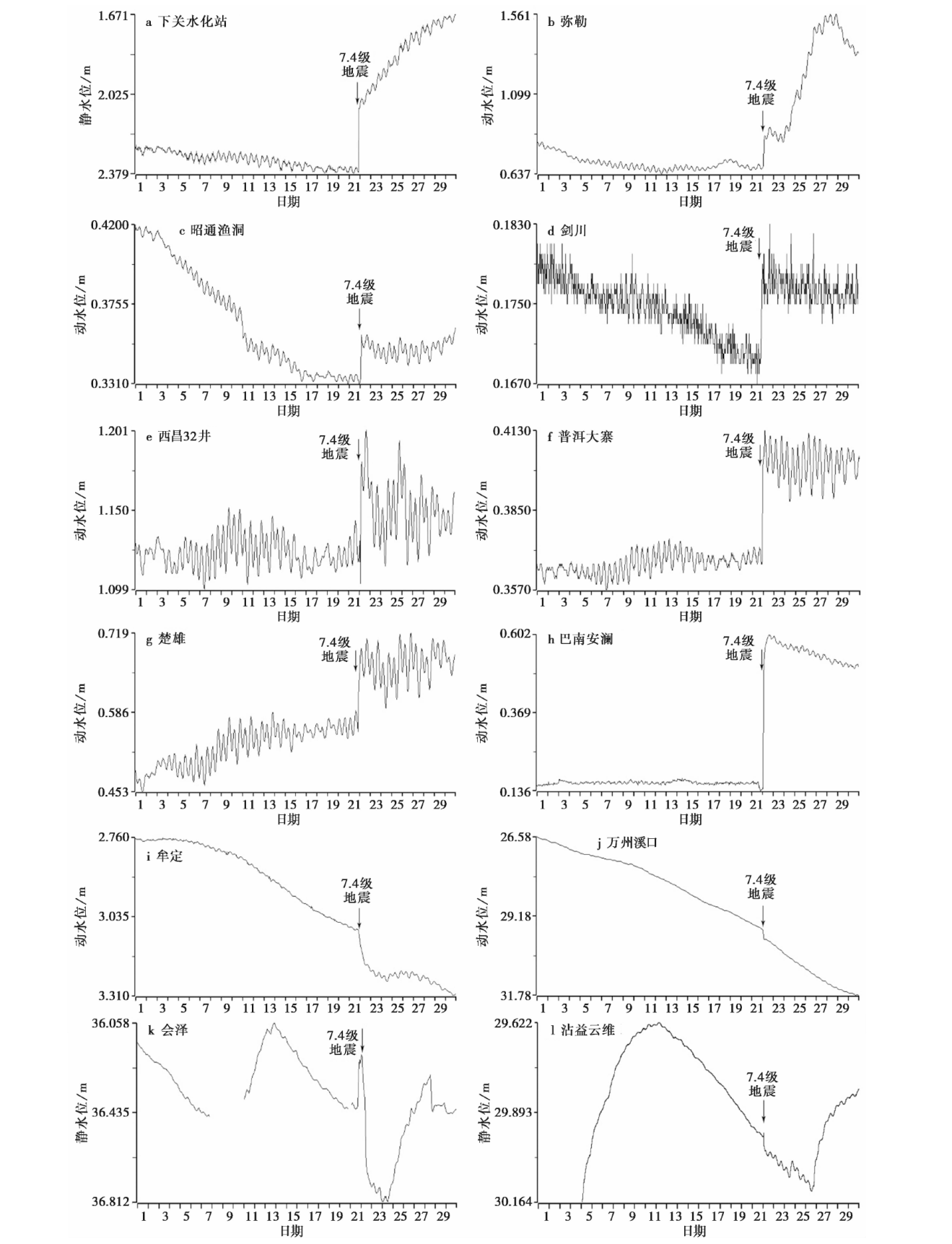
Fig. 2 Coseismic variation curves of water levels of some wells in the Sichuan-Yunnan region after the M7.4 earthquake occurred in Madoi, Qinghai.
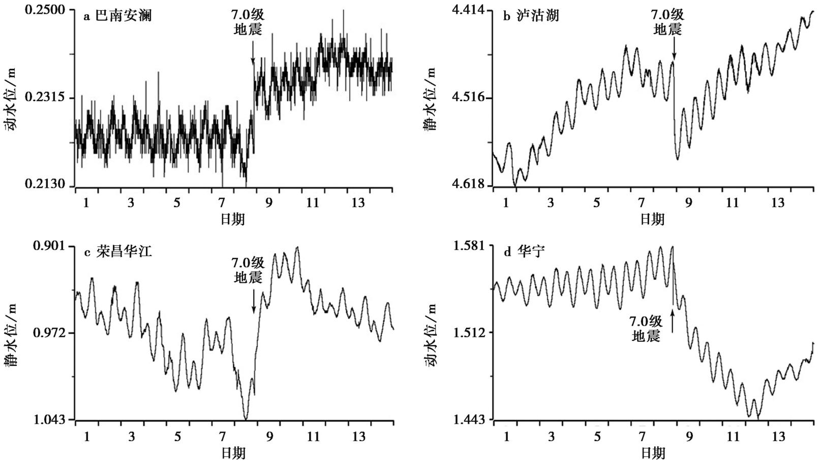
Fig. 3 Cosesimic variation curves of water levels of some wells in the Sichuan-Yunan region after the M7.0 Jiuzhaigou earthquake.
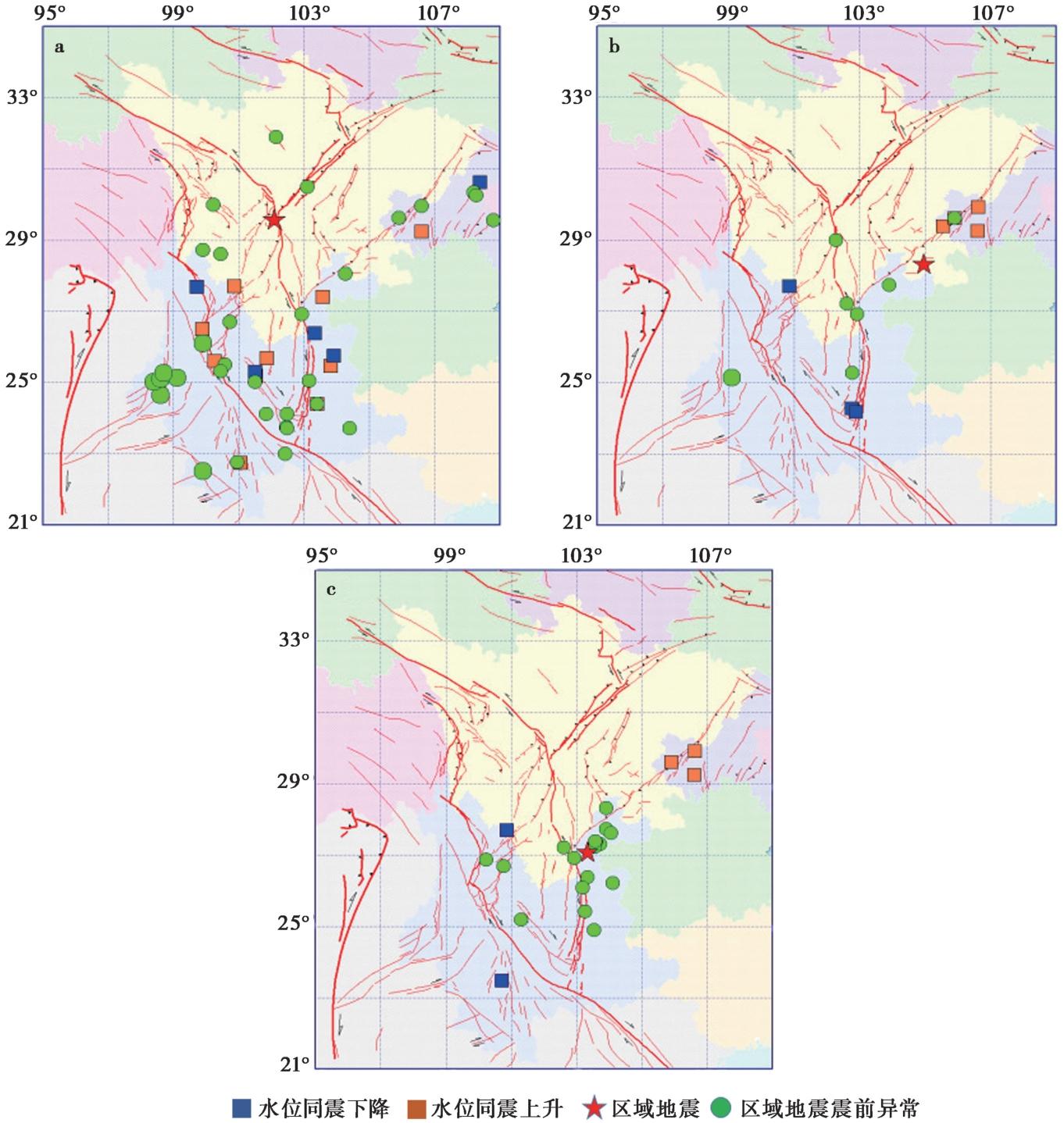
Fig. 4 The distribution of coseismic changes in fluid well levels in the Sichuan-Yunan region after several major earthquakes and the corresponding distribution of regional earthquakes with MS≥6.0.
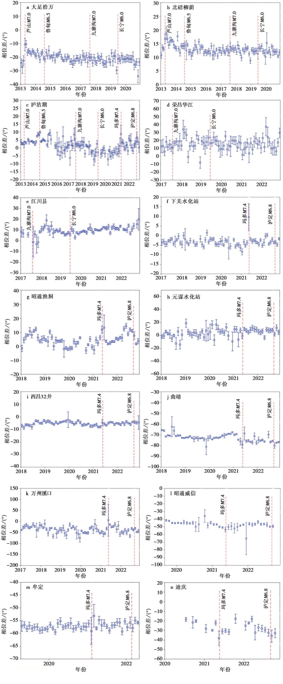
Fig. 5 Phase lag variation curves of each fluid well.
| 远大地震 | 测井名 | 同震形态 | 大震前后井水位相位差变化 |
|---|---|---|---|
| 2013-04-20, 芦山7.0级地震 | 北碚柳荫 | 同震阶升 | 先变大随后缓慢降低回落,在2014年8月3日鲁甸6.5级地震后恢复 |
| 大足拾万 | 同震阶升 | 先变大随后缓慢降低回落,在2014年8月3日鲁甸6.5级地震后恢复 | |
| 泸沽湖 | 同震阶降 | 由快速下降转化为缓慢上升,到2014年8月达到最高值,鲁甸6.5级地震后恢复 | |
| 2017-08-08, 九寨沟7.0级地震 | 荣昌华江 | 同震阶升 | 缓慢上升,继而缓慢回落,2018年6月恢复到正常水平 |
| 泸沽湖 | 同震阶降 | 从震前的高值到震后的快速回落恢复 | |
| 江川县局 | 同震阶降 | 快速下降,继而缓慢上升,2018年5月达到最高值后回落,2019年长宁6.0级地震前恢复 | |
| 2021-05-22, 玛多7.4级地震 | 下关水化站 | 同震阶升 | 快速上升、快速回落恢复 |
| 西昌32井 | 同震阶升 | 快速上升、快速回落恢复 | |
| 泸沽湖 | 同震阶升 | 先快速上升后缓慢回落,泸定6.8级地震后恢复 | |
| 昭通渔洞 | 同震阶升 | 先快速上升后缓慢回落,泸定6.8级地震后恢复 | |
| 曲靖 | 同震阶升 | 先快速上升后缓慢回落 | |
| 万州溪口 | 同震阶升 | 先快速上升后缓慢回落 | |
| 牟定 | 同震阶降 | 快速下降和快速恢复 | |
| 昭通威信 | 同震阶降 | 下降后缓慢恢复 | |
| 迪庆 | 同震阶降 | 下降后缓慢恢复 |
Table3 The changes in water level and phase lag differences in various fluid wells before and after major earthquakes
| 远大地震 | 测井名 | 同震形态 | 大震前后井水位相位差变化 |
|---|---|---|---|
| 2013-04-20, 芦山7.0级地震 | 北碚柳荫 | 同震阶升 | 先变大随后缓慢降低回落,在2014年8月3日鲁甸6.5级地震后恢复 |
| 大足拾万 | 同震阶升 | 先变大随后缓慢降低回落,在2014年8月3日鲁甸6.5级地震后恢复 | |
| 泸沽湖 | 同震阶降 | 由快速下降转化为缓慢上升,到2014年8月达到最高值,鲁甸6.5级地震后恢复 | |
| 2017-08-08, 九寨沟7.0级地震 | 荣昌华江 | 同震阶升 | 缓慢上升,继而缓慢回落,2018年6月恢复到正常水平 |
| 泸沽湖 | 同震阶降 | 从震前的高值到震后的快速回落恢复 | |
| 江川县局 | 同震阶降 | 快速下降,继而缓慢上升,2018年5月达到最高值后回落,2019年长宁6.0级地震前恢复 | |
| 2021-05-22, 玛多7.4级地震 | 下关水化站 | 同震阶升 | 快速上升、快速回落恢复 |
| 西昌32井 | 同震阶升 | 快速上升、快速回落恢复 | |
| 泸沽湖 | 同震阶升 | 先快速上升后缓慢回落,泸定6.8级地震后恢复 | |
| 昭通渔洞 | 同震阶升 | 先快速上升后缓慢回落,泸定6.8级地震后恢复 | |
| 曲靖 | 同震阶升 | 先快速上升后缓慢回落 | |
| 万州溪口 | 同震阶升 | 先快速上升后缓慢回落 | |
| 牟定 | 同震阶降 | 快速下降和快速恢复 | |
| 昭通威信 | 同震阶降 | 下降后缓慢恢复 | |
| 迪庆 | 同震阶降 | 下降后缓慢恢复 |
| [1] |
常祖峰. 2015. 2013年云南奔子栏M5.9地震发生的地震地质背景[J]. 地震地质, 37(1): 192-207. doi: 10.3969/j.issn.0253-4967.2015.15.
|
|
|
|
| [2] |
陈立德, 付虹. 2003. 地震预报基础与实践[M]. 北京: 地震出版社:262.
|
|
|
|
| [3] |
付虹, 刘丽芳, 王世芹, 等. 2002. 地方震及近震地下水同震震后效应研究[J]. 地震, 22(4): 55-66.
|
|
|
|
| [4] |
巩浩波, 来贵娟, 李翠平, 等. 2022. 重庆荣昌井水温同震-震后响应特征及机理研究[J]. 中国地震, 38(4): 737-750.
|
|
|
|
| [5] |
国家地震局科技监测司. 1990. 地震学分析预报方法程式指南[M]. 北京: 地震出版社:74.
|
|
Department of Science and Technology Monitoring, State Seismological Bureau. 1990. Program Guide for Seismological Analysis and Prediction Methods[M]. Earthquake Magazine Press, Beijing: 74 (in Chinese).
|
|
| [6] |
胡小静, 付虹, 李琼. 2018. 滇南地区近期水位趋势上升异常机理初探[J]. 地震学报, 40(5): 620-631.
|
|
|
|
| [7] |
胡小静, 付虹, 李涛, 等. 2020. 云南普洱大寨井水位同震响应研究及预测意义[J]. 地震研究, 43(2): 340-347.
|
|
|
|
| [8] |
贾化周, 张炜, 董守玉, 等(主编) 1995. 地震地下水手册[M]. 北京: 地震出版社: 322-324.
|
|
|
|
| [9] |
蒋海昆(主编). 2019a. 中国地震(2007-2012)[M]. 北京: 地震出版社: 673-696.
|
|
|
|
| [10] |
蒋海昆(主编). 2019b. 中国地震(2013)[M]. 北京: 地震出版社: 168-289.
|
|
|
|
| [11] |
蒋海昆(主编). 2019c. 中国地震(2014-2015)[M]. 北京: 地震出版社: 1-461.
|
|
|
|
| [12] |
李利波, 姚休义, 李智蓉, 等. 2017. 云南地区水位、 水温对尼泊尔 MS8.1 地震的响应特征研究[J]. 地震工程学报, 39(4): 677-685.
|
|
|
|
| [13] |
李四光. 1974. 旋钮构造[M]. 北京: 科学出版社.
|
|
|
|
| [14] |
廖丽霞, 王玫玲, 吴绍祖. 2009. 福建省流体台网井水位的同震效应及其地震预测意义[J]. 地震学报, 31(4): 432-441.
|
|
|
|
| [15] |
马宏生, 刘杰, 吴昊, 等. 2004. 基于R值评分的年度地震预报能力评价[J]. 地震, 4(2): 31-37.
|
|
|
|
| [16] |
毛巍颖. 2018. 云南思茅大寨井水位地震同震响应特征分析[J]. 地震研究, 41(4): 577-582.
|
|
|
|
| [17] |
缪阿丽, 祝涛, 张艺, 等. 2023. 2021年青海玛多7.4级地震的江苏流体井水位同震响应特征[J]. 地震研究, 46(1): 68-73.
|
|
|
|
| [18] |
任宏微, 张磊. 2017. 尼泊尔 MW8.1 地震对我国大陆井水位动态的影响及其地震预测意义[J]. 大地测量与地球动力学, 37(10): 1087-1091.
|
|
|
|
| [19] |
邵志刚(主编). 2022. 中国地震(2019)[M]. 北京: 地震出版社.
|
|
|
|
| [20] |
孙小龙, 向阳. 2018. 基于同震水震波的水文地质参数求取方法探讨[J]. 水文地质工程地质, 45(3): 22-29.
|
|
|
|
| [21] |
陶志刚, 王晓, 祝杰, 等. 2022. 青海门源 MS6.9 地震井水位与水温同震响应特征分析[J]. 中国地震, 38(3): 399-411.
|
|
|
|
| [22] |
王启欣, 徐锡伟, 江在森. 2020. 南北地震带现今应变特征及地震危险性分析[J]. 大地测量与地球动力学, 40(1): 23-29.
|
|
|
|
| [23] |
王阎昭, 王恩宁, 沈正康, 等. 2008. 基于GPS资料约束反演川滇地区主要断裂现今活动速率[J]. 中国科学(D辑), 38(5): 582-597.
|
|
|
|
| [24] |
王莹, 赵韬, 胡景, 等. 2021. 2021年云南漾濞6.4级地震序列重定位及震源机制解特征分析[J]. 地震地质, 43(4): 847-863. doi: 10.3969/j.issn.0253-4967.2021.04.007.
|
|
DOI |
|
| [25] |
吴中海, 赵根模, 龙长兴, 等. 2014. 青藏高原东南缘现今大震活动特征及其趋势: 活动构造体系角度的初步分析结果[J]. 地质学报, 88(8): 1401-1416.
|
|
|
|
| [26] |
向阳, 孙小龙, 杨鹏涛, 等. 2020. 2019年长宁M6.0和2018年兴文M5.7地震引起的井水位同震响应对比分析[J]. 地震, 40(2): 155-165.
|
|
|
|
| [27] |
许绍燮. 1989. 地震预报能力评分[A]. 北京: 地震出版社: 586-589.
|
|
|
|
| [28] |
徐锡伟, 闻学泽, 郑荣章, 等. 2003. 川滇地区活动块体最新构造变动样式及其动力来源[J]. 中国科学(D辑), 33(S1): 151-162.
|
|
|
|
| [29] |
徐晓雪, 季灵运, 蒋锋云, 等. 2020. 基于GPS和小震研究金沙江断裂带现今活动特征[J]. 大地测量与地球动力学, 40(10): 1062-1067.
|
|
|
|
| [30] |
许英才, 郭祥云. 2023a. 2022年四川马尔康 MS6.0 强震群重定位及发震断层探讨[J]. 地震地质, 45(4): 1006-1024. doi: 10.3969/j.issn.0253-4967.2023.04.012.
|
|
|
|
| [31] |
许英才, 郭祥云. 2023b. 2022年6月1日四川芦山 MS6.1 地震的震源参数及其构造启示[J]. 地球物理学报, 66(8): 3202-3217.
|
|
|
|
| [32] |
许志琴, 王勤, 李忠海, 等. 2016. 印度-亚洲碰撞: 从挤压到走滑的构造转换[J]. 地质学报, 90(1): 1-23.
|
|
|
|
| [33] |
薛艳, 张小涛, 晏锐, 等. 2022. 2022年四川泸定 MS6.8 地震前地震活动与地球物理观测异常回顾与讨论[J]. 中国地震, 38(4): 601-612.
|
|
|
|
| [34] |
杨竹转, 邓志辉, 高小其, 等. 2010. 新疆乌鲁木齐04号井数字化水位同震阶变的研究[J]. 中国地震, 26(3): 329-339.
|
|
|
|
| [35] |
易桂喜, 龙锋, 梁明剑, 等. 2023. 2022年9月5日四川泸定 MS6.8 地震序列发震构造[J]. 地球物理学报, 66(4): 1363-1384.
|
|
|
|
| [36] |
张培震. 2008. 青藏高原东缘川西地区的现今构造变形、 应变分配与深部动力过程[J]. 中国科学(D辑), 38(9): 1041-1056.
|
|
|
|
| [37] |
张培震, 王琪, 马宗晋. 2002. 青藏高原现今构造变形特征与GPS速度场[J]. 地学前缘, 9(2): 442-450.
|
|
|
|
| [38] |
赵韬, 王莹, 马冀, 等. 2021. 2021年青海玛多7.4级地震序列重定位和震源机制特征[J]. 地震地质, 43(4): 790-805. doi: 10.3969/j.issn.0253-4967.2021.04.004.
|
|
DOI |
|
| [39] |
郑勇, 李细兵, 王焕, 等. 2018. 印支期龙门山断裂带的逆冲-推覆构造和沉积响应[J]. 地质评论, 64(1): 45-61.
|
|
|
|
| [40] |
周龙泉(主编). 2021. 中国地震(2017)[M]. 北京: 地震出版社: 114-253.
|
|
|
|
| [41] |
|
| [42] |
DOI URL |
| [43] |
DOI |
| [44] |
|
| [45] |
|
| [46] |
DOI URL |
| [47] |
PMID |
| [48] |
DOI URL |
| [49] |
DOI URL |
| [50] |
|
| [51] |
|
| [52] |
DOI URL |
| [53] |
|
| [54] |
|
| [55] |
|
| [56] |
DOI URL |
| [57] |
|
| [58] |
DOI URL |
| [59] |
|
| [60] |
|
| No related articles found! |
| Viewed | ||||||
|
Full text |
|
|||||
|
Abstract |
|
|||||
Copyright © SEISMOLOGY AND GEOLOGY, All Rights Reserved.
Tel: 010-62009049/9063 E-mail: dzdz@ies.ac.cn
Powered by Beijing Magtech Co., Ltd.