夏垫断裂带古地震事件在断塞塘沉积物中的响应
于晓辉1,2), 沈军2,*), 戴训也2), 王昌盛2)
1) 中国地震局地质研究所, 活动构造室, 北京 100029
2) 防灾科技学院, 活动构造与地震地质灾害重点实验室, 北京 101601
*通讯作者: 沈军, 男, 研究员, E-mail: shenjuneq@qq.com

〔作者简介〕 于晓辉, 男, 1982年生, 现为中国地震局地质研究所构造地质学专业在读博士研究生, 主要研究方向为活动构造, E-mail: 23315022@qq.com

摘要

文中通过断层坎前崩积楔、 断塞塘这类古地震识别标志, 分析了夏垫断裂的古地震事件, 讨论了古地震形成的断塞塘沉积物的岩性组合与沉积演化规律。 以三河-平谷 MS8.0地震地表破裂带作为研究区, 以倾滑为主的发震断层形成的断塞塘沉积作为主要研究对象, 利用崩积楔、 断塞塘沉积识别古地震事件, 结合第四纪年代学数据在夏垫断裂潘各庄探槽中识别出自晚更新世25~12kaBP以来的4次古地震事件。 通过地表高程测量和钻孔探测确定断塞塘的展布规模和充填序列, 利用探槽揭露断塞塘充填的地层序列和岩性组合关系, 并基于此分析了古地震事件发生后在发震断裂附近形成的断塞塘沉积垂向上的3个变化阶段。 研究表明, 断塞塘沉积充填序列自下而上由崩积楔及其形成的冲刷面或不整合面、 细碎屑堆积物(含生物碎屑)以及古土壤组成。

关键词: 断塞塘; 崩积楔; 古地震
中图分类号:P546 文献标志码:A 文章编号:0253-4967(2019)04-0872-15
THE RESPONSE OF SAG POND SEDIMENT TO THE PALEOEARTHQUAKE EVENT ON THE XIADIAN FAULT ZONE
YU Xiao-hui1,2), SHEN Jun2), DAI Xun-ye2), WANG Chang-sheng2)
1) Institute of Geology, China Earthquake Administration, Beijing 100029, China
2) Key Laboratory of Active Tectonics and Seismic Geological Hazards, Institute of Disaster Prevention, Beijing 101601, China
Abstract

The wedge-shaped deposit formed in front of fault scarp is called colluvial wedge. Repeated faulting by faults may produce multiple colluvial wedges, each of which represents a paleoseismic event. When there are two or more colluvial wedges, the new colluvial wedge is in sedimentary contact with the fault, while the old ones are in fault contact with the fault. The shape of colluvial wedge is usually in the form of horizontal triangle, and the sedimentary facies is usually of binary structure. The overall grain size decreases gradually from bottom to top. Soil layer generally develops on the top, and different types of soil are developed under different climate or soil environments. Another deposit in front of fault scarp is the sag pond graben. The graben in front of sag pond is generally a set of sedimentary assemblages of colluvial facies, alluvial diluvial facies and swamp facies. The area close to the fault, especially the main fault, is of colluvial facies, while the area away from the fault is of alluvial and pluvial facies and marshy facies. In an accumulative cycle, the size of the deposit decreases from bottom to top, and soil layers develop on the top or surface. Multiple pile-ups may be a marker for identifying multiple faulting events. The pile-up strata such as colluvial wedge and fault sag pond can be used as identification markers for paleoseismic events. Colluvial wedge and sag pond, as the identification markers for paleoearthquake, have been well applied to practical research. However, there is still lack of detailed research on the lithological structure and genetic evolution in the interior of colluvial wedge and sag pond sediment, meanwhile, there is still a deficiency in the analysis of the completeness and the regional characteristics of paleoearthquake by using colluvial wedge and sag pond sediment. This paper discusses the method of identifying paleoearthquake by using sag pond sediments and colluvial wedge. We discuss the lithologic combination and sedimentary evolution of sag pond and choose the surface rupture zone of the 1679 M8.0 earthquake on the Xiadian Fault as the research area. In this paper, the distribution range and filling sequence of sag pond are analyzed, using borehole exploration. Four paleoearthquake events are identified since 25ka to 12ka, based on the sag pond sediments and colluvial wedge. The in situ recurrence interval of these seismic events is 480a, 510a,7630a and2830a, respectively. The lithologic combination and sedimentary evolution law of the sag pond sediments caused by an ancient earthquake are discussed. The sag pond distribution range and filling sequence are determined by the surface elevation survey and drilling exploration. The exploratory trench exposes the sag pond filling strata sequence and lithologic combination. Based on this, we analyze the three sedimentation stages of sag pond sediments formed by a paleoearthquake event near the earthquake fault. It is believed that the filling sequence is composed from bottom to top of the colluvial wedge, the erosion surface or unconformity surface, the fine detrital sediments(containing biological debris)and paleosols. For the fault-sag ponds formed by active faults, the paleoearthquakes occurred near the unconformity or erosion surface of the sediments of the fault-plug ponds. An ancient earthquake event includes the combination of organic deposits such as sediments, clastic deposits, bioclasts, burrow, plant roots and other organic deposits on the vertical scour surface or unconformity. The time interval between two paleoseismic events is defined by two adjacent unconformities(or scour surfaces). According to the vertical facies association and chronological test results of the sediments in the Pangezhuang trough of the Xiatan Fault, four paleo-seismic events are identified since the late Pleistocene period of 25~12kaBP, with recurrence intervals of 480a, 510a,7630a and2830a, respectively.

Keyword: sag pond; colluvial wedge; paleoearthquake
0 引言

断层陡坎在坎前形成的楔状堆积物被称为崩积楔(colluvial wedge)。 断层重复的断错作用可能产生多个崩积楔, 每个崩积楔代表1次古地震事件(Swan et al., 1980)。 当存在2个及以上崩积楔时, 新的崩积楔与断层为沉积接触, 而老的崩积楔与断层为断层接触。 崩积楔的形态一般为卧三角状, 沉积相往往具有二元结构(Nelson, 1987), 下部为分选较差的粗颗粒洪积相或重力相, 上部为分选较好的细颗粒流水相, 整体上粒度自下向上逐渐变细(Eschard et al., 1998)。 顶部一般发育土壤层, 不同气候或土质环境发育不同类型的土壤(冯有良等, 2000; 邓起东等, 2004; 冉勇康等, 2012, 2014)。 断层陡坎在坎前的另一种堆积物是断塞塘坎前地堑。 断塞塘坎前地堑一般是一套崩积相、 冲洪积相及沼泽相的沉积组合(Yeats et al., 1996)。 靠近断层、 尤其是主断层的部位为崩积相, 离开断层为冲洪积相和沼泽相堆积。 对于堆积旋回, 堆积物粒径自下而上逐渐变细, 顶部或表面往往发育土壤层。 多个堆积组合体可能是识别多次断错事件的标志。

崩积楔、 断塞塘这类坎前堆积地层可以作为古地震事件的识别标志(Kidd et al., 1988; Wallace, 1990; Allen et al., 1991; 丁国瑜, 1995; 宋方敏等, 1998; 冉勇康等, 1999; Guo et al., 2006)。 这一识别标志在贺兰山断裂、 大青山断裂以及西秦岭北缘断裂都有很好的应用。 前人在贺兰山东麓断裂通过探槽开挖揭示的坎前砾石崩积楔、 充填楔以及小地堑堆积, 识别了4次古地震事件; 在贺兰山西麓断裂利用坎前发育的黄土崩积楔识别了2次断错事件; 大青山山前断裂表现出崩积楔和充填楔共生的现象, 并且这种共生地层呈现下部为砾石堆积, 上部为砂土堆积的结构特征(吴卫民等, 1995); 在西秦岭北缘断裂带, 李传友等(2010)利用坎前断塞塘的沉积韵律作为标志识别了古地震。

崩积楔、 断塞塘作为形貌标志, 在识别古地震中发挥了很好的作用, 但针对崩积楔、 断塞塘内部的岩性结构以及成因演化方面尚缺乏精细研究(冉勇康等, 1999)。 同时, 在利用崩积楔、 断塞塘分析区域古地震的完整性以及古地震的区域性特点等方面尚有欠缺。 本文以三河-平谷MS8.0地震发震断层形成的断塞塘为主要研究对象, 识别出晚更新世25~12k aBP以来的4次古地震事件, 分析了古地震形成断塞塘沉积物的3个阶段, 总结出断塞塘沉积物自下而上由崩积楔及其形成的冲刷面或不整合面、 细碎屑堆积物(含生物碎屑)以及古土壤等组成的特征。

1 研究区构造概况

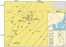
夏垫断裂是华北平原区北部一条重要的NE向隐伏活动断裂, 走向N50° E, 倾向SE, 是北京东部大厂凹陷与通县凸起2个第四纪构造单元间的边界断裂(图1)。 早期受该断裂控制的大厂凹陷持续下降, 第四纪沉积物厚600~700m, 通县凸起第四纪堆积物厚度仅为300~400m(徐锡伟等, 2000)。 1679年三河-平谷MS8.0地震是夏垫断裂最新一次地表破裂型地震事件, 在地表形成了长约10km的地震断层陡坎, 显示出东南盘下降、 北西盘上升的正断倾滑性质, 兼具右旋走滑分量(彭一民等, 1981; 孟宪梁等, 1983; 向宏发等, 1988)。

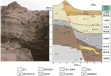
图 1 区域构造断裂展布图(据冉勇康等, 1997修改)
1 晚更新世以来的活动断层; 2 第四纪活动断层; 3 1679年地震形变带; 4 第四系等深线(单位: m); 5 基岩出露区; 6 探槽位置; 7 浅层地震勘探测线位置; 8 钻孔位置; 9 地貌高程测线位置; 10 地震震级M6.0~6.9; 11 地震震级M≥ 7
Fig. 1 Distribution of regional tectonic faults(adapted after RAN Yong-kang et al., 1997).

在古地震研究方面, 冉勇康等(1997)根据东柳河屯附近的探槽揭露推测, 距今20ka以来夏垫断裂上发生过4次地表破裂型古地震, 前2次为砂土液化显示的事件, 后2次为直接断错证据标识的事件。 4次事件发生的时间分别约为距今20ka、 13ka、 7.5ka和317a, 平均重复间隔为(6.56± 0.69)ka, 显示了准周期的重复特征。 江娃利等(2000)根据齐心庄探槽推测, 全新世以来夏垫断裂发生过4次强震事件; 徐锡伟等(2000)利用钻孔通过构造地层学和年代学鉴定定量恢复了夏垫断裂距今26ka以来的11次地表破裂古地震事件。

发生于1679年9月2日的三河-平谷8级地震(震中烈度Ⅺ )是北京及附近地区历史上记录到的最大地震。 自20世纪80年代以来, 众研究者对该地震及其发震构造开展了大量的研究, 包括地质、 微地貌、 浅层物探、 化探以及钻探等, 取得了一些认识(何宏林等, 2008; 贾辉等, 2008; 刘保金等, 2009a, b; 杨晓平等, 2012; 何付兵等, 2013; 秦向辉等, 2014)。 本次工作在前人成果的基础上, 针对古地震形成的断塞塘开展相关研究, 以期在沉积覆盖区的发震断裂古地震识别方面进行进一步探索。

2 地貌测量与断塞塘揭露

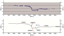
采用RTK进行跨断层的地貌测量, 测线位于齐心庄镇潘各庄村以南存在明显地震断层陡坎的区域(图1), 垂直于断裂走向, 长
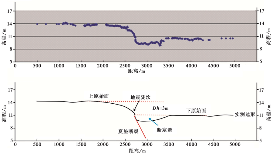
 5000m。 地貌测量表明, 在陡坎下部地貌面反倾(图2)。 上、 下原始面垂直位移量近3m, 这与冉勇康等(1997)提出的潘各庄全新世最新的2次地震事件的位移为3.16m较为吻合。 同时地貌测量也确定了近地表断塞塘的大致位置(图2), 为下一步浅层钻探工作以及探槽开挖奠定了基础。

图 2 RTK高精度地貌测量
Dh
为上、 下原始面的高差
Fig. 2 RTK high-precision geomorphic measurement.

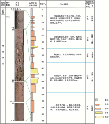
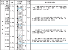
为进一步确定断塞塘沉积与其它正常沉积的区别, 在断层下盘坎前断塞塘的位置布设了钻孔ZK1, 在距离钻孔ZK1东南100m的位置布设了钻孔ZK2(图5)。 2个钻孔揭露了深度为80m的地层。 钻孔ZK1揭露的0~15m深的地层为浅棕黄色粉砂与灰色黏土(图3), 均发育水平层理, 黏土层发育有黑色炭质纹层, 为河漫滩及牛轭湖沉积; 15~35m深的地层为分选好的中、 细砂, 局部夹砾石, 底部发育粗砂, 磨圆差, 含砾石较多, 为河流边滩、 心滩沉积; 35~50m深的地层为灰色黏土, 炭质纹层及炭粒较发育, 为断塞塘沉积; 50~70m深的地层为棕黄色中、 粗砂, 层理发育, 分选、 磨圆好, 含有砾石, 为河流边滩、 心滩沉积; 70~75m深的地层为灰色黏土, 局部夹黄褐色粉砂质黏土条带, 为断塞塘沉积。

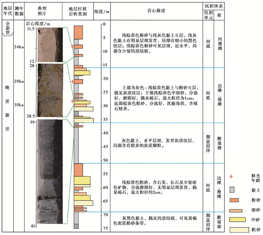
图 3 钻孔ZK1地层柱状图Fig. 3 The stratigraphic column of borehole ZK1.

钻孔ZK2揭露的0~16m深的地层为浅棕黄色粉砂与灰色黏土(图4), 层理发育, 黏土层发育有黑色炭质纹层, 为河漫滩及牛轭湖沉积; 16~30m深的地层上部为粉、 细砂, 底部为棕黄色中砂, 分选、 磨圆好, 局部夹砾石, 粒径最大为1cm, 为河流边滩、 心滩沉积; 30~40m深的地层为灰色黏土, 炭质纹层发育, 发育黄褐色粉砂, 层理发育, 为河漫滩及牛轭湖沉积; 40~65m深的地层为棕黄色中、 粗砂, 层理发育, 分选、 磨圆好, 主要矿物成分为石英、 长石以及少量暗色矿物, 含有砾石, 最大粒径为4cm, 为河流边滩、 心滩沉积; 65~85m深的地层上部为浅黄色黏土, 偶见钙质结核, 中部为浅黄色粉砂, 下部为黄色黏土, 地层未见底, 为河漫滩沉积。

图 4 钻孔ZK2地层柱状图Fig. 4 The stratigraphic column of borehole ZK2.

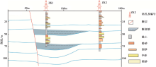
钻孔ZK2揭露的上盘沉积地层主要为河流相沉积, 岩性为黏土、 粉砂、 细砂以及中粗砂。 断层附近的钻孔ZK1揭露的地层在36~50m以及70~75m深处发育厚层的炭质黏土, 而钻孔ZK2并没有揭露这种地层(图5), 因此认为这2套炭质黏土层是断裂活动形成的2期断塞塘, 每期断塞塘的上部均被河湖相沉积物超覆。

图 5 钻孔探测揭露的断塞塘展布Fig. 5 The exposure of the broken plug pond by drilling.

图 6 探槽剖面素描图Fig. 6 Profile sketch of exploratory trench.

3 探槽开挖与古地震识别

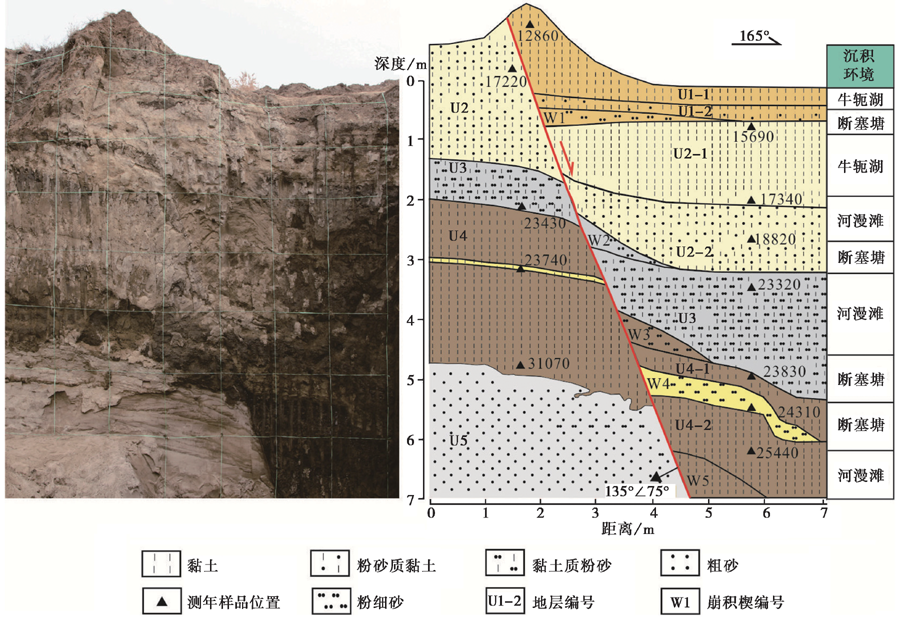
本研究在地貌测量与浅层钻探工作的基础上开展了探槽工作, 主要目的是揭露断裂及断塞塘沉积序列, 以期在断塞塘沉积中识别出古地震事件。 探槽位于齐心庄镇潘格庄村南400m的采土坑, 长7m、 深7m。 探槽揭露了晚更新世1 2860~2 5440aiBP的沉积地层, 包含黏土、 粉砂质黏土、 粉砂、 细砂、 粗砂5种岩性(图4), 包含岩性单元16套。 获得14C测年数据12个, 主要测试样品为黏土以及夹层黏土, 14C样品测试单位为北京大学第四纪年代学测定实验室。

上盘地层描述如下:

U1-1层为灰黄色黏土, 顶部14C年龄为(12.86± 0.035)ka(测试样品为黏土), 地层未见顶; 层内见壳类碎片, 有薄层植物根系组成的古土壤层, 为牛轭湖与古土壤沉积。

U1-2层为浅灰色粉砂质黏土, 层厚0.6m, 为断塞塘上部沉积。

W1层为浅灰褐色粉细砂崩积楔, 整体形态呈楔状, 由下部细砂向上变为粉砂, 下部颜色为深灰褐色, 至上部变为浅灰褐色, 下部颗粒分选磨圆差, 向上逐渐变好, 为断塞塘沉积。

U2-1层为浅黄色黏土, 层厚0.7m, 地层近水平, 发育水平层理, 底部局部含炭, 有少量植物根系组成的古土壤层, 顶部的14C年龄为(15.69± 0.045)ka(测试样品为黏土); 下部为淡黄色黏土, 地层底面平直, 粒度向上逐渐变细, 为牛轭湖古土壤沉积。

U2-2层为灰褐色粉砂质黏土, 层厚0.5~0.8m, 该套地层的倾斜与构造牵引变形有关, 地层的14C年龄为(17.34± 0.045)ka(测试样品为黏土); 下部为浅灰褐色粉砂质黏土, 层厚0.3~0.6m, 14C年龄为(18.82± 0.05)ka(测试样品为黏土), 为断塞塘上部沉积。

W2层为浅灰褐色粉细砂崩积楔; 整体形态呈楔状, 由于断裂的牵引, 地层向下倾斜, 楔体由下部细砂逐渐变为粉砂, 下部颜色由深灰逐渐变为浅灰色, 为断塞塘沉积。

U3为灰色黏土质粉砂, 层厚1.0~1.5m, 14C年龄为(23.32± 0.07)ka(测试样品为黏土)。

W3层为浅灰褐色粉细砂崩积楔, 整体形态呈楔状, 由于断裂的牵引, 地层向下倾斜, 楔体由下部细砂逐渐变为粉砂, 下部颜色由深灰褐逐渐变为浅灰褐色, 为断塞塘沉积。

U4-1层为灰褐色黏土, 层厚0.2~0.4m, 该层顶部的14C年龄为(23.83± 0.08)ka(测试样品为黏土)。

W4层为浅灰黄色粉细砂崩积楔; 整体形态呈楔状, 楔体尾部有弯曲变形现象。 由于断裂的牵引, 地层向下倾斜。 楔体由下部细砂逐渐变为粉砂, 颜色为灰黄色, 为断塞塘沉积。

U4-2层为深褐色黏土, 顶部的14C年龄为(24.31± 0.08)ka(测试样品为黏土), 底部的14C年龄为(25.44± 0.08)ka(测试样品为砂质黏土), 局部见小型断层造成的地层错断。

W5为深褐色黏土, 呈楔形崩积楔, 地层结构较为松散。 整体形态呈楔状, 由于断裂的牵引, 地层向下倾斜。 楔体由黏土组成, 整体颜色为深褐色。

下盘地层分为4个地层单元, 地层结构较上盘简单, 描述如下:

U2层为浅灰黄色粉砂质黏土, 厚约3m; 沉积厚度稳定, 水平层次发育, 靠近断层有牵引变形, 底部的14C年龄为(23.43± 0.07)ka(测试样品为黏土)。

U3层为浅灰褐色黏土质粉砂, 厚1.1m, 中部夹有薄层粉细砂。

U4层为深褐色黏土, 厚约3m, 中间夹一薄层粉砂, 该层顶部、 中部、 底部的14C年龄分别为(23.43± 0.07)ka(测试样品为黏土)、 (23.74± 0.08)ka(测试样品为夹层黏土)和(31.07± 0.14)ka(测试样品为黏土)。

U5层为灰白色粗砂, 层厚2.5m, 未见底界, 大型斜层理发育。

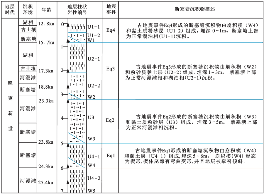
在探槽剖面中共识别出4次古地震事件, 古地震事件1(Eq1)的沉积序列埋深5~6m, 底部为W4粉细砂崩积楔, 向上变细为U4-1黏土层。 断塞塘由W4和U4-1组成, W4底部年龄为2 4310a。 古地震事件2(Eq2)的沉积序列埋深3~5m, 底部为W3粉砂崩积楔, 向上变细为U3黏土质粉砂。 断塞塘由W3和U3下部地层构成, 向上逐渐过渡为正常的河漫滩沉积。 U4-1地层顶部的年龄为2 3830a。 古地震事件3(Eq3)的沉积序列埋深1~3m, 底部为W2的粉砂崩积楔, 向上变细为U2-2粉砂质黏土及U2-1黏土。 断塞塘沉积由W2及U2-2底部地层组成, 向上逐渐过渡为正常沉积的U2-2顶部河漫滩以及U2-1湖泊相沉积。 U3顶部年龄为2 3320a。 古地震事件4(Eq4)的沉积序列埋深0~1m, 底部为W1细砂崩积楔, 向上变细为U1-2粉砂质黏土及U1-1黏土。 断塞塘沉积由W1及U1-2组成, 向上逐渐过渡为U1-1湖相沉积。 U2-1的顶部年龄为1 2860a(图7)。

图 7 古地震事件分析Fig. 7 Analysis of ancient seismic events.

对探槽揭露地层进行分析后推断, 当断塞塘被填满后, 在区域沉降作用的影响下, 断层上盘的断塞塘沉积物被正常沉积的河湖相沉积所覆盖。 古地震事件Eq2的U3地层上部由断塞塘填满后, 被区域河流漫滩沉积物超覆; 古地震事件Eq3的U2-2、 U2-1地层由断塞塘填满后, 被湖泊相沉积物超覆。 古地震事件Eq1的U3地层上部由断塞塘填满后, 被河流漫滩沉积物超覆; 古地震事件Eq4的U1-1地层由断塞塘填满后, 在区域沉降作用下形成了湖泊相沉积物。

4 断塞塘沉积与古地震事件

断塞塘的规模以及填充的沉积物很好地记录了断裂的活动历史, 且沉积物的组合规律也与古地震事件之间存在相关性, 可利用断塞塘中沉积物的变化规律综合分析地层中的古地震事件。

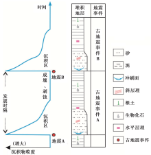
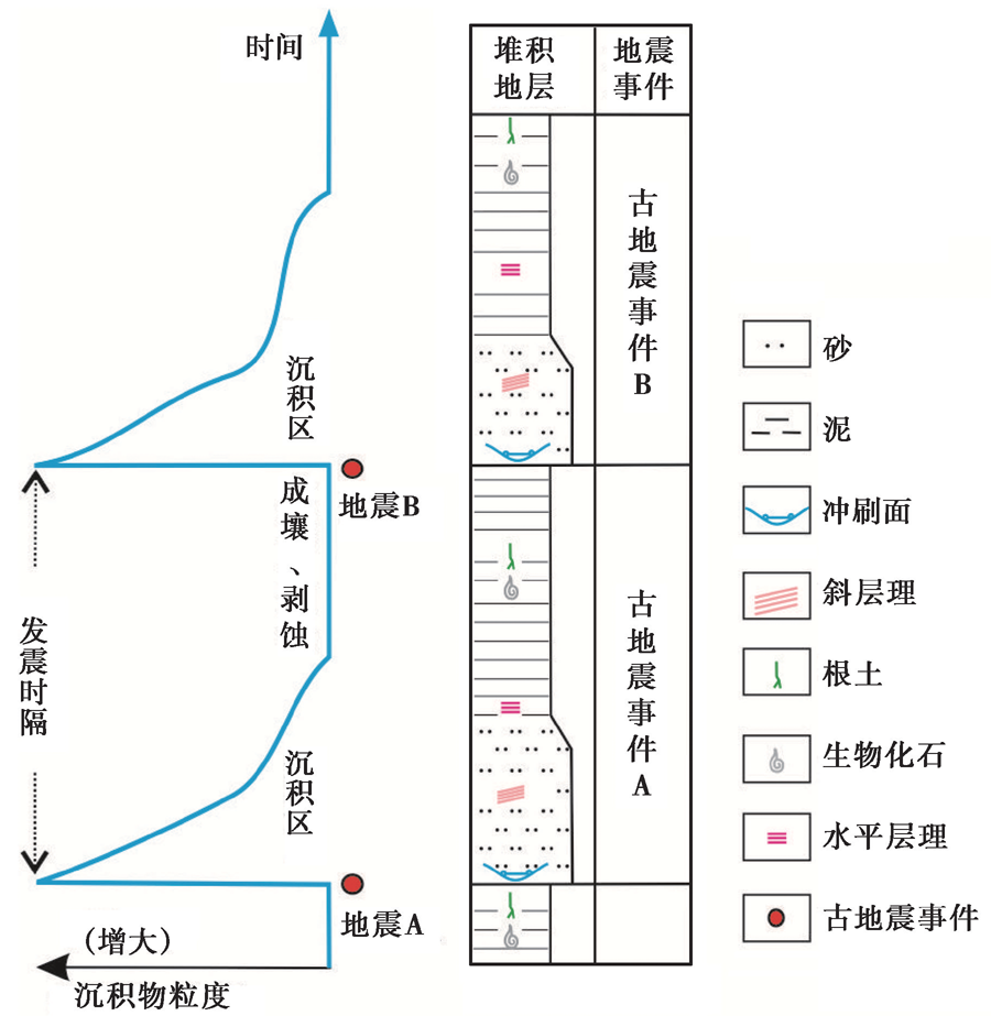
依据夏垫断裂探槽揭露的断塞塘沉积物与识别的古地震事件, 认为当地表破裂型古地震事件发生后, 在断裂带附近形成的断塞塘堆积区将发生3个阶段的变化: 1)在强震发生后, 地表破裂造成断层上盘水平错动以及垂直下降, 此时断塞塘中的沉积物粒度大, 堆积速度快; 2)随着断塞塘中沉积物的不断堆积, 沉降速率越来越慢, 此时断塞塘中的沉积物粒度逐渐变细; 3)当断塞塘被沉积物填满后, 将进入成壤与剥蚀阶段。

依据断塞塘沉积演化的3个阶段, 总结了古地震事件断塞塘的堆积物特征(图8)。 在地震初期, 沉积物快速堆积, 主要以粗颗粒为主, 堆积速率快, 主要发育崩积楔和粗颗粒沉积物, 形成冲刷面及斜层理等沉积构造。 随后, 水体变浅, 断塞塘将逐渐进入沼泽化阶段, 此时堆积物主要为细粒的黏土、 粉土、 亚砂土等, 由于此时主要以静水环境为主, 发育水平层理, 且沉积物中富含生物碎屑, 最终断塞塘被填满, 顶部发育古土壤层。 当下一次地表破裂型古地震事件发生时, 将重复以上堆积过程。 初期, 发育崩积楔和粗颗粒沉积物, 并对上一次古地震事件形成的古土壤层进行冲刷, 形成底部的冲刷面, 分析认为对于活动断裂形成的断塞塘, 古地震发生在断塞塘沉积物的不整合面或冲刷面附近。 2次古地震事件的发震间隔为2个相邻不整合面(或冲刷面)所限定的时间。

图 8 古地震与断塞塘沉积的关系Fig. 8 The relationship between paleo-earthquake and sag pond sediments.

5 古地震序列与复发行为

根据识别出的夏垫断裂晚更新世25~12kaiBP的4次古地震事件, 结合测年数据对古地震序列和复发行为进行了讨论。 古地震事件Eq1发生的时间为24.31k aBP; 古地震事件Eq2发生的时间为23.83k aBP; 古地震事件Eq3发生的时间为23.32k aBP; 古地震事件Eq4发生的时间为15.69k aBP。 进而得到4次古地震事件的发震间隔为480a、 510a、 7630a和 2830a(表1)。

表1 12~25k aBP期间夏垫断裂上的地表破裂型古地震事件 Table1 The surface rupture type paleoseismic events on the Xiadian Fault during the period from 12k aBP to 23k aBP

徐锡伟等(2000)利用钻孔构造地层学和年代学资料, 定量地恢复了距今26ka以来夏垫断裂上的11次古地震事件, 其中12~25k aBP有7次古地震事件, 与本次工作揭露的古地震事件存在一定的对应关系。 古地震事件Eq1与钻孔构造地层识别的第10次古地震事件的年龄基本一致, 均为24ka; 古地震事件Eq4与钻孔构造地层识别的第5次古地震事件的年龄均约16ka, 而古地震事件Eq2、 Eq3与钻孔构造地层识别的第6~9次古地震事件丛集落在相同的时间范围内。

6 结论

(1)在以走滑为主兼正断的断层区域, 当地表破裂型古地震事件发生后, 发震断裂下降盘形成的断塞塘堆积区中的沉积物将进行3个阶段的变化: 1)在强震发生后, 地表破裂造成断层上盘水平错动以及垂直下降, 此时断塞塘中的沉积物快速堆积且粒度较大; 2)随着断塞塘中的沉积物的不断堆积, 沉降速率越来越慢, 此时断塞塘中的沉积物的粒度开始变细并逐渐填满断塞塘; 3)当断塞塘被沉积物填满后, 沉积物不再沉积, 此时断塞塘将进入成壤与剥蚀阶段。

(2)对于活动断裂形成的断塞塘, 古地震发生在断塞塘沉积物的不整合面或冲刷面附近。 1次古地震事件所生成的沉积序列在垂向上由冲刷面或不整合面、 碎屑堆积物、 生物碎屑、 潜穴、 植物根系等有机堆积物组成。 2次古地震事件的发震间隔为2个相邻不整合面(或冲刷面)所限定的时间。

(3)依据断塞塘沉积物的垂相组合以及年代学测试结果, 在夏垫断裂潘各庄探槽中识别出了晚更新世25~12k aBP以来的4次古地震事件, 地震事件的复发间隔分别为480a、 510a、 7630a和 2830a。

参考文献
[1] 邓起东, 陈立春, 冉勇康. 2004. 活动构造定量研究与应用[J]. 地学前缘, 11(4): 383392.
DENG Qi-dong, CHEN Li-chun, RAN Yong-kang. 2004. Quantitative studies and applications of active tectonics[J]. Earth Science Frontiers, 11(4): 383392(in Chinese). [本文引用:1]
[2] 丁国瑜. 1995. 阿尔金活断层的古地震与分段[J]. 第四纪研究, 15(2): 97106.
DING Guo-yu. 1995. Paleoearthquake along the Altun Fault and its segmentation[J]. Quaternary Sciences, 15(2): 97106(in Chinese). [本文引用:1]
[3] 冯有良, 李思田, 解习农. 2000. 陆相断陷盆地层序形成动力学及层序地层模式[J]. 地学前缘, 7(3): 119132. doi: 10.3321/j.issn:1005-2321.2000.03.013.
FENG You-liang, LI Si-tian, XIE Xi-nong. 2000. Dynamics of sequence generation and sequence stratigraphic model in continental rift-subsidence basin[J]. Earth Science Frontiers, 7(3): 119132(in Chinese). [本文引用:1]
[4] 何付兵, 白凌燕, 王继明, . 2013. 夏垫断裂带深部构造特征与第四纪活动性讨论[J]. 地震地质, 35(3): 490505. doi: 10.3969/j. issn. 0253-4967. 2013. 03. 004.
HE Fu-bing, BAI Ling-yan, WANG Ji-ming, et al. 2013. Deep structure and Quaternary activities of the Xiadian fault zone[J]. Seismology and Geology, 35(3): 490505(in Chinese). [本文引用:1]
[5] 何宏林, 闵伟, 原口强. 2008. 1679年三河-平谷8级地震破裂带的大地切片实验研究[J]. 地震地质, 30(1): 289297.
HE Hong-lin, MIN Wei, YUAN Kou-qiang. 2008. Testing geo-slicer on the rupture of the M8 Sanhe-Pinggu earthquake of 1679[J]. Seismology and Geology, 30(1): 289297(in Chinese). [本文引用:1]
[6] 贾辉, 何正勤, 叶太兰. 2008. 用瞬态多道瑞利波法研究夏垫隐伏断裂附近的浅层速度结构变化[J]. 地震地磁观测与研究, 29(1): 1519.
JIA Hui, HE Zhen-qin, YE Tai-lan. 2008. Detecting variation of near surface velocity structure near Xiadian buried fault with transient multi channel surface wave[J]. Seismological and Geomagnetic Observation and Research, 29(1): 1519(in Chinese). [本文引用:1]
[7] 江娃利, 侯治华, 肖振敏, . 2000. 北京平原夏垫断裂齐心庄探槽古地震事件分析[J]. 地震地质, 22(4): 413422. doi: 10.3969/j. issn. 0253-4967. 2000. 04. 010.
JIANG Wa-li, HOU Zhi-hua, XIAO Zhen-min, et al. 2000. Study on paleoearthquakes of Qixinzhuang trench at the Xiadian Fault, Beijing Plain[J]. Seismology and Geology, 22(4): 413422(in Chinese). [本文引用:1]
[8] 李传友, 张培震, 袁道阳, . 2010. 活动走滑断裂上断塞塘沉积特征及其构造含义: 以西秦岭北缘断裂带断塞塘为例[J]. 地质学报, 84(1): 90105.
LI Chuan-you, ZHANG Pei-zhen, YUAN Dao-yang, et al. 2010. Sedimentary characteristics of sag-pond on the active strike-slip fault and its tectonic implications: An example from sag pond along the West Qinling Fault[J]. Acta Geologica Sinica, 84(1): 90105(in Chinese). [本文引用:1]
[9] 刘保金, 胡平, 陈颙, . 2009a. 北京平原西北部地壳浅部结构和隐伏活动断裂: 由地震反射剖面揭示[J]. 地球物理学报, 52(8): 7585. doi: 10.3969/j. issn. 0001-5733. 2009. 08. 009.
LIU Bao-jin, HU Ping, CHEN Yong, et al. 2009a. The crustal shallow structures and buried active faults revealed by seismic reflection profiles in northwestern area of Beijing Plain[J]. Chinese Journal of Geophysics, 52(8): 7585(in Chinese). [本文引用:1]
[10] 刘保金, 胡平, 孟勇奇, . 2009b. 北京地区地壳精细结构的深地震反射剖面探测研究[J]. 地球物理学报, 52(9): 8290. doi: 10.3639/j. issn. 0001-5733. 2009. 09. 010.
LIU Bao-jin, HU Ping, MENG Yong-qi, et al. 2009b. Research on fine crustal structure using deep seismic reflection profile in Beijing region[J]. Chinese Journal of Geophysics, 52(9): 8290(in Chinese). [本文引用:1]
[11] 孟宪梁, 杜春涛, 王瑞, . 1983. 1679年三河-平谷大震的地震断裂带[J]. 地震, (3): 1823.
MENG Xian-liang, DU Chun-tao, WANG Rui, et al. 1983. Rupture of the Sanhe-Pinggu earthquake of 1679[J]. Earthquake, (3): 1823(in Chinese). [本文引用:1]
[12] 彭一民, 李鼎容, 谢振钊, . 1981. 北京平原区同生断裂的某些特征及其研究意义[J]. 地震地质, 3(2): 5764.
PENG Yi-min, LI Ding-rong, XIE Zhen-zhao, et al. 1981. Some features of contemporaneous faults on Beijing plain and their significance[J]. Seismology and Geology, 3(2): 5764(in Chinese). [本文引用:1]
[13] 秦向辉, 张鹏, 丰成君, . 2014. 北京地区地应力测量与主要断裂稳定性分析[J]. 地球物理学报, 57(7): 21652180. doi: 10.6038/cjg20140712.
QIN Xiang-hui, ZHANG Peng, FENG Cheng-jun, et al. 2014. In-situ stress measurements and slip stability of major faults in Beijing region, China[J]. Chinese Journal of Geophysics, 57(7): 21652180(in Chinese). [本文引用:1]
[14] 冉勇康, 邓起东. 1999. 古地震学研究的历史、 现状和发展趋势[J]. 科学通报, 44(1): 1220.
RAN Yong-kang, DENG Qi-dong. 1999. History, status and development of paleoseismology[J]. Chinese Science Bulletin, 44(1): 1220(in Chinese). [本文引用:2]
[15] 冉勇康, 邓起东, 杨晓平, . 1997. 1679年三河-平谷8级地震发震断层的古地震及其重复间隔[J]. 地震地质, 19(3): 193201.
RAN Yong-kang, DENG Qi-dong, YANG Xiao-ping, et al. 1997. Paleoearthquakes and recurrence interval on the seismogenic fault of 1679 Sanhe-Pinggu M8 earthquake, Hebei and Beijing[J]. Seismology and Geology, 19(3): 193201(in Chinese). [本文引用:2]
[16] 冉勇康, 李彦宝, 杜鹏, . 2014. 中国大陆古地震研究的关键技术与案例解析(3): 正断层破裂特征、 环境影响与古地震识别[J]. 地震地质, 36(2): 287301. doi: 10.3969/j. issn. 0253-4967. 2014. 02. 001.
RAN Yong-kang, LI Yan-bao, DU Peng, et al. 2014. Key techniques and several cases analysis in paleoseismic studies in mainland China(3): Rupture characteristics, environment impact and paleoseismic indicators on normal faults[J]. Seismology and Geology, 36(2): 287301(in Chinese). [本文引用:1]
[17] 冉勇康, 王虎, 李彦宝, . 2012. 中国大陆古地震研究的关键技术与案例解析(1): 走滑活动断裂的探槽地点、 布设与事件识别标志[J]. 地震地质, 34(2): 197210. doi: 10.3969/j. issn. 0253-4967. 2012. 02. 001.
RAN Yong-kang, WANG Hu, LI Yan-bao, et al. 2012. Key techniques and several cases analysis in paleoseismic studies in mainland China(1): Trenching sites, layout and paleoseismic indicators on active strike-slip faults[J]. Seismology and Geology, 34(2): 197210(in Chinese). [本文引用:1]
[18] 宋方敏, 汪一鹏. 1998. 中国活断层研究专辑: 小江活动裂带 [M]. 北京: 地震出版社: 2252.
SONG Fang-min, WANG Yi-peng. 1998. Collected Works on Active Fault Research in China: Xiaojiang Active Fault Zone [M]. Seismological Press, Beijing: 2252(in Chinese). [本文引用:1]
[19] 吴卫民, 李克, 马保起, . 1995. 大青山山前断裂带大型组合探槽的全新世古地震研究[G]//国家地震局地质研究所编. 活动断裂研究(4). 北京: 地震出版社: 123132.
WU Wei-min, LI Ke, MA Bao-qi, et al. 1995. Research on Holocene paleoearthquakes using large combined trench along the Daqingshan piedmont fault, Inner Mongolia [G]//Institute of Geology, SSB(ed). Research on Active Faults(4). Seismological Press, Beijing: 123132(in Chinese). [本文引用:1]
[20] 向宏发, 方仲景, 徐杰, . 1988. 三河-平谷8级地震区的构造背景与大震重复性研究[J]. 地震地质, 10(1): 1528.
XIANG Hong-fa, FANG Zhong-jing, XU Jie, et al. 1988. Seismotectonic background and recurrence interval of great earthquakes in 1679 Sanhe-Pinggu M=8 earthquake area[J]. Seismology and Geology, 10(1): 1528(in Chinese). [本文引用:1]
[21] 徐锡伟, 计凤桔, 于贵华, . 2000. 用钻孔地层剖面记录恢复古地震序列: 河北夏垫断裂古地震研究[J]. 地震地质, 22(1): 919.
XU Xi-wei, JI Feng-ju, YU Gui-hua, et al. 2000. Reconstruction of paleoearthouake sequence using stratigraphic records from drill logs: A study at the Xiand ian Fault, Beijing[J]. Seismology and Geology, 22(1): 919(in Chinese). [本文引用:3]
[22] 杨晓平, 曹景虎, 陈献程. 2012. 夏垫活动断裂两盘岩心氧化铁变化[J]. 地震地质, 34(4): 659671. doi: 10.3969/j. issn. 0253-4967. 2012. 04. 010.
YANG Xiao-ping, CAO Jing-hu, CHEN Xian-cheng. 2012. The iron oxide changes in drilling cores from the two walls of Xiand ian active fault[J]. Seismology and Geology, 34(4): 659671(in Chinese). [本文引用:1]
[23] Allen C R, Luo Z, Qian H, et al. 1991. Field study of a highly active fault zone: The Xianshuihe Fault of southwestern China[J]. Geological Society of America Bulletin, 103(9): 11781199. [本文引用:1]
[24] Eschard R, Lemouzy P, Bacchiana C, et al. 1998. Combining sequence stratigraphy, geostatistical simulations, and production data for modeling a fluvial reservoir in the Chaunoy Field(Triassic, France)[J]. American Accociation of Petroleum Geologists Bulletin, 82(4): 545567. [本文引用:1]
[25] Guo J, Lin A, Maruyama T, et al. 2006. New constraints on recent large earthquakes along the Xidatan-Dongdatan segment of the Kunlun Fault, western China[J]. Bulletin of the Seismological Society of America, 96(1): 4858. doi: 10.1785/0120040176. [本文引用:1]
[26] Kidd W S F, Molnar P. 1988. Quaternary and active faulting observed on the 1985 Acdamia Sinica-Royal Society Geotraverse of Tibet[J]. Philosophical Transactions of the Royal Society of London, Series A, Mathematical and Physical Sciences, 327(1594): 337363. doi: 10.1098/rsta.1988.0133. [本文引用:1]
[27] Nelson A R. 1987. A facies model of colluvial sedimentation adjacent to a single-event normal-fault scarp, basin and range province, western United States[R]. USGS Open File Report, 87-683: 136145. [本文引用:1]
[28] Swan F, Schwartz D P, Cluff L S. 1980. Recurrence of moderate to large magnitude earthquakes produced by surface faulting on the Wasatch fault zone, Utah[J]. Bulletin of the Seismological Society of America, 70(5): 14311462. [本文引用:1]
[29] Wallace R E. 1990. The San Andreas fault system, California[J]. US Geological Survey Professional Paper, 1515: 1618. [本文引用:1]
[30] Yeats R S, Prentice C S. 1996. Introduction to Special Section: Paleoseismology[J]. Journal of Geophysical Research Solid Earth, 101(B3): 58475853. doi: 10.1029/95JB03134. [本文引用:1]