


金沙江中游永胜昔格达层软沉积变形构造
[王莅斌1, 2)  , 尹功明
, 尹功明1), * , 袁仁茂1) , 王盈1) , 苏刚3) ]
, 尹功明, 袁仁茂|
|


〔作者简介〕 王莅斌, 男, 1994生, 2020年于中国地质大学(北京)获地质工程专业硕士学位, 现为中国地震局地质研究所科研助理, 主要研究方向是地震地质灾害, E-mail: wlb2033@163.com。
在一定的地质环境中, 地震可引起大范围的砂土液化和软沉积变形, 所造成的破坏可能远大于地震震动直接造成的破坏。 金沙江中游的永胜县涛源镇沿江分布有大面积的昔格达组湖相沉积物。 同时, 活动性强、 地震频发的程海断裂带正好从永胜县涛源镇一带通过。 在昔格达组未固结时, 可能发生过1次强烈的地震触发了昔格达组的变形。 基于研究剖面的变形特征分析认为: 地震触发的大规模软沉积变形构造剖面中需存在砂层, 下伏砂层、 上覆黏土层的 “二元结构”是地震触发软沉积变形构造的理想地层结构, 且下伏砂层的厚度和变形强度决定了上覆黏土层变形强度; 砂层中含有上覆黏土挤落的团块等非原层物质, 砂层的上、 下层面高低起伏不平; 黏土层中的主要变形构造有地层错位、 无根断层、 砂层挤入、 砂层管道、 黏土层复杂褶曲、 负载构造、 火焰构造和肿缩构造等; 变形构造样式复杂, 无明显规律, 且可形成大规模的强烈地层变形。
The neotectonic movement in the middle reaches of the Jinsha River is active and the earthquakes occur frequently. Lacustrine sediments are commonly distributed on both sides of the river with stable sedimentary environment, good horizontal continuity and relatively developed stratification, which are good carriers for recording paleo-seismic events. In this study, a large number of soft sedimentary deformation structures are found in the riverside lacustrine sediments in the Taoyuan Town area in the middle reaches of Jinsha River, with strong deformation and large scale. We focus on the comprehensive analysis of four soft-sedimentary deformation profiles. In which the profiled strata are mainly medium-fine sand and clay. And the soft sedimentary deformation structures mainly include sand liquefaction, rootless faults, clay lumps and folds.
Causes analysis: In the profiles of soft sedimentary deformation structures, there are medium and fine sand layers whose thickness is from thick to super thick. Sedimentary bedding has not been observed in the sand layer; and a large number of clay debris or lumps are involved in the sand layer, which are often filled between the adjacent clay lumps; and there are quicksand channels in the sand layer. All the features indicate that the sand layer in the study profiles has been liquefied. In the study profile, we found that the soft sedimentary deformation structure has the following characteristics: The faults found in the study profile extend downward and terminate in the lower liquefied sand layer and a large number of clay lumps. There are clay lumps in the place where the clay fold structure develops, and a large number of liquefied sand bodies are filled between the fold structures. The deformation structures in the profiles are not contrastive in terms of extension, chaotic deformation characteristics and obvious stress direction. Based on the characteristics of sand liquefaction and clay deformation in the above profile, it is inferred that the deformation structure in the profile is mainly due to sand liquefaction. The liquefaction strength of sand layer determines the deformation degree of clay layer.
Trigger factors analysis: There are many factors that can trigger the liquefaction deformation of the unconsolidated sediment, such as flood, freeze-thaw, collapse and earthquake, which can cause the liquefaction deformation of the sediment under certain conditions. In this paper, the possible trigger factors are analyzed based on the combination of the structural characteristics of soft sedimentary deformation, sedimentary environment and geological background of the area. First the stratigraphic characteristics also reflect the hydrostatic sedimentary environment at that time. The soft sedimentary deformation on such a large scale could not be mainly caused by the disturbance of lake waves. The research profiles are located at a sheltered bay with weak hydrodynamics, and no alluvial strata have been found in the upper part of the soft sedimentary deformation stratum. Moreover, the soft sedimentary deformation structure caused by flooding is often a small-scale curly layered structure, which has a large difference with the deformation structure and scale in the study profiles. This suggests that alluvial and diluvial events are not the main triggering factors of the deformation. Although the landslide is likely to occur near the study area, no trace of bedrock landslide is found near the study profiles. Therefore, the invasion of bedrock landslide into the sedimentary layer cannot be the triggering factor. Moreover, the occurrence of lacustrine sedimentary layer is nearly horizontal, which is a relatively stable sedimentary state, and it is impossible to form such a large-scale slump structure due to its own gravity effect. And we don't find any sliding surface in the profiles. Therefore, the collapse is ruled out. According to the geological background and geological survey of the study area, this area does not have the conditions triggered by volcanism, glaciation and freeze-thaw. Because of the active neotectonic movement and frequent earthquakes in the study area, and seismic actions are the main trigger factors for liquefaction. So it is considered that seismic action may be the main trigger factor for the strong liquefaction deformation in the study area. According to the previous studies, the relationship between the soft sedimentary deformation structure, the liquefaction thickness and the seismic strength is discussed, the magnitude of this ancient seismic event probably reached 7 or higher.
There are sand layers in the section of “soft sedimentary deformation structure” caused by earthquake, the lower stratum is sand layer and the upper stratum is clay layer. The thickness and deformation strength of the lower sand layer determine the strength of the deformation structure of the overlying clay layer. The upper and lower surface of the sand layer are undulating, and there are clay lumps in the sand layer. The deformation structure of clay layer is complex and there is no obvious deformation rule.
2018年印度尼西亚发生的帕卢7.0级地震导致帕卢全城被毁。 地震发生时, 建筑物上下起伏、 旋转, 出现像河流一样流动的现象, 使得地表房屋被严重挤压以致倒塌。 由于帕卢市处于滨海地区, 地表之下为含水量较高的砂层, 地震引发的砂土液化导致松软沉积物变形, 并伴生了大面积灾害。 帕卢地震表明, 在一定的地质环境中, 地震砂土液化所造成的破坏可能远大于地震震动直接造成的破坏。 近年来, 中国的地震主要发生在西部山区, 所引发的大规模的地震软沉积变形灾害较少, 对地震软沉积变形(或砂土液化)的研究相对较弱。 然而, 中国中、 东部地区的许多城市位于河流两岸、 海滨地带, 地震软沉积变形或砂土液化灾害的威胁仍不可忽视, 在该领域开展相关的研究工作依然具有重要意义。
“ 软沉积变形构造” 指沉积物在未脱离沉积环境和尚未完全固结的状态下, 因遭受物理力的作用而形成的一系列变形构造(张斌等, 2011; 冯增昭, 2018)。 目前, 对软沉积变形构造的成因分析与触发因素的识别一直以来都是该领域的难点问题。 在各地区的软沉积变形构造研究中, 多数软沉积变形构造被认为是由地震活动引起的(Shiki et al., 2000; Montenat et al., 2007; Mał gorzata et al., 2018), 但实际上其成因较多, 洪水、 滑坡、 海啸、 风暴、 重力流和行星撞击等都可能引起软沉积变形(Bhattacharya et al., 1998; Simms, 2003; McLaughlin et al., 2004; Moretti et al., 2007; Rana et al., 2016)。
中国的软沉积变形构造研究多以岩石地层中的软沉积变形构造为研究对象(杜远生等, 2000; 戴朝成等, 2009; 苏德辰等, 2011, 2013; 龚正等, 2013; 田洪水等, 2016; 杨文涛等, 2017), 而对未成岩的湖相沉积物中的变形构造研究较少, 研究区域也主要集中于青藏高原东缘岷江流域(安卫平等, 2008; 王萍等, 2009; 张斌等, 2011; 李艳豪, 2015; Jiang et al., 2014, 2016; 钟宁, 2017)。
对金沙江进行水电开发的过程中, 在涛源镇下游建成了鲁地拉水库, 淹没了库区原村居, 村民向两岸高处搬迁, 新村居地点的基础建设和山地改造工作揭露出大量新鲜剖面。 近期, 我们在永胜县涛源镇金沙江中游进行考察时发现, 在金沙江两岸太极— 寨子村约30km区域内, 其昔格达组中存在大量的软沉积变形构造、 喷沙管道以及断层剖面。 本文将以其中具有典型性和代表性的4个剖面为例, 对其内的软沉积变形构造进行详细阐述, 并总结出相应的特征。
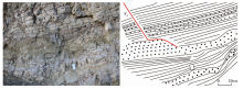
川滇地区位于青藏高原东南缘, 是开展青藏高原物质向SE逃逸理论研究的重要地段。 现今的GPS观察结果表明, 川滇菱形块体相对于欧亚大陆以约10mm/a的速度向SE运动(Gan et al., 2007)。 永胜县涛源镇位于川滇菱形块体的西部, 附近的程海断裂带是滇西北地区的一条重要的活动断裂带, 近SN向展布, 由一系列近平行的断层组成, 全长约200km(国家地震局地质研究所等, 1990), 可分为金官-程海断裂带、 期纳断裂带与宾川断裂带等(图 1)。 1511年, 在程海断裂带上发生了滇西北最大的地震— — 永胜7.5级地震, 现今该区中小地震频发。
 | 图 1 程海断裂带的构造简图(修改自徐锡伟等, 2003; 黄小巾等, 2018)Fig. 1 Structural sketch of Chenghai fault zone(revised from XU Xi-wei et al., 2003; HUANG Xiao-jin et al., 2018). |
金沙江从云南永胜县涛源镇流过, 在金沙江干流及支流两岸断续分布由灰白色、 灰黄色的中细砂与灰黄色、 紫红色黏土、 亚黏土构成的湖相沉积地层, 地层中可见清晰的水平层理, 处于半成岩状态。 湖相地层海拔标高1 200~1 500m。 徐则民等(2011)将这套明显追踪金沙江及其支流分布的湖相沉积物归为昔格达组。 昔格达组为一套以昔格达村出露点命名的湖相沉积层, 由粉砂、 粉砂质黏土与黏土构成(袁复礼, 1958; 罗运利等, 1998; 刘慧军等, 2004; 李乾坤等, 2011; 朱正峰等, 2018)。
本文选取的4个软沉积变形构造剖面分布在涛源镇下力农村的两侧(图 2)。 各剖面中保存有大量的无根断层、 黏土团块、 褶曲、 肿缩构造等软沉积变形构造。
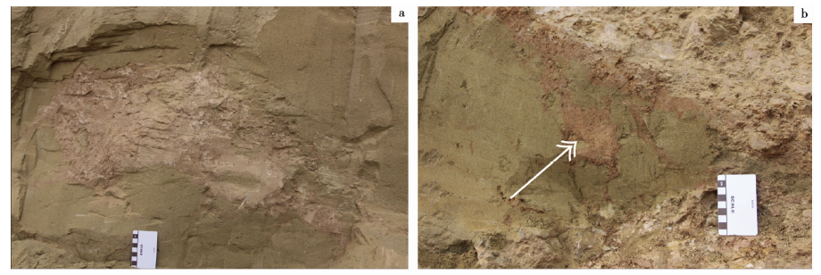
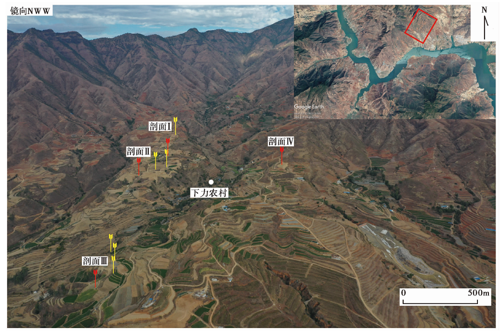 | 图 2 软沉积变形构造剖面的分布位置 红色标记为本文的研究剖面, 黄色为本文未详细阐述的软沉积变形构造发育的剖面Fig. 2 Photos of the profile location of the soft-sedimentary deformation structure. |
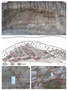
剖面Ⅰ (26.235 674° N, 100.498 771° E; 海拔1 400m)位于下力农村西侧山脊顶部(图 2), 该剖面是研究区内软沉积变形构造剖面分布区域内最高的。 剖面上部覆盖约1m厚的耕植土层, 下部地层主要为灰色、 灰黄色黏土层与灰黄色砂层。 黏土层厚约1.3m, 整体倾向230° , 倾角约为15° , 层理清晰, 中间夹有中厚— 薄层细砂。 下伏黄褐色中砂层, 最厚处约为2m, 无层理, 下部未见底。 该剖面宏观上可见F1— F5 5条近平行的无根断层(图3a), F1、 F2断层无明显的滑动面, 由黏土层碎屑与砂混合构成了断层碎屑带(图3c)。 断层碎屑带或断层面在上覆耕植土与下伏砂层中未见延续, 仅发育于黏土层中。 黏土层在其与下伏砂层接触面附近较为破碎(图3d), 通过地层对比发现黏土层底部有地层缺失现象。 黏土层间的中细砂层发育有肿缩变形构造, 在该中细砂层上、 下的黏土层均较为破碎(图3b)。
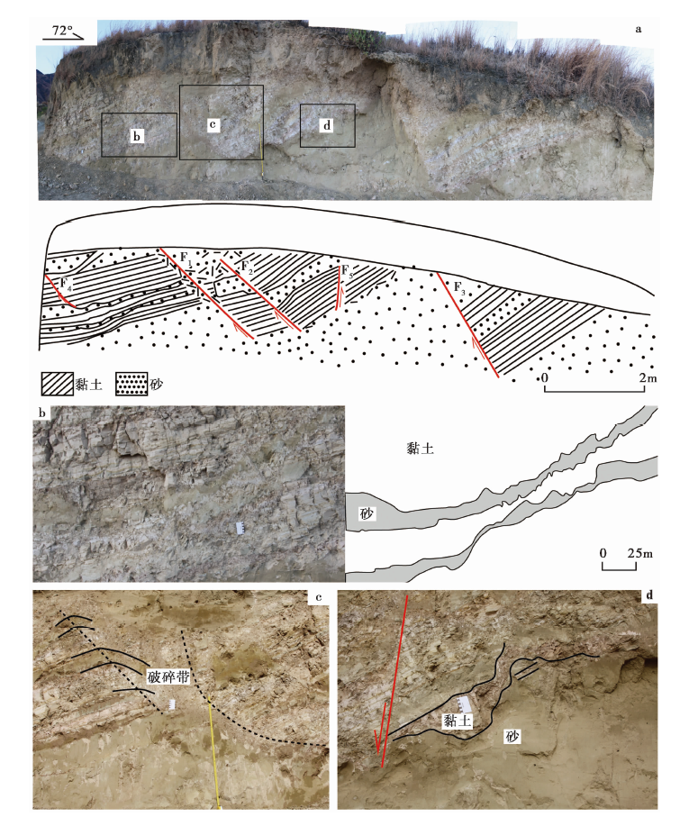 | 图 3 永胜县涛源镇剖面Ⅰ 的照片与剖面图 a 剖面的整体照片与剖面图; b 夹于黏土层间的中细砂层形成的肿缩变形构造; c 断层F1形成的破碎带与断层下盘地层形成的牵引褶曲(卷尺长1m); d 黏土与砂层交界处的破碎残缺Fig. 3 Photos and cross section diagrams of profile I in Taoyuan Town, Yongsheng County. |
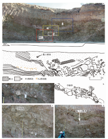
剖面Ⅱ (26.233 815° N, 100.499 581° E; 海拔1 375m)位于剖面Ⅰ 沿山脊线方向的下方, 2条剖面的直线距离约为300m(图 2)。 剖面Ⅱ 的走向与剖面Ⅰ 近平行, 上部有1.5~3m厚的残、 坡积物覆盖, 湖相沉积层出露呈弧型, 右侧有厚约2m的卵砾石层(图4a)。 该剖面的湖相沉积地层整体倾向约为220° , 倾角约为6° , 下部为青灰色细砂层, 厚约1m, 上部黏土层间夹有2层黄灰色细砂层。 剖面中发育一系列平行无根断层, 其中断距> 10cm的断层有10条, 断层面平直清晰, 断层两侧的地层发育有小牵引弯(图4b), 断层切穿剖面中的湖相沉积层, 未切割上覆的坡积物与砂砾石层。 黏土层下部发育有大量断距< 1cm的层间微断层(图4c)。 黏土层的破碎程度向上逐渐增加, 湖积物顶部与上部坡积物接触带形成黏土碎屑与砂砾石的混合层。
 | 图 4 永胜县涛源镇剖面Ⅱ 照片与剖面图 a 剖面Ⅱ 的整体照片与剖面图; b 断层两盘黏土层形成的摩擦牵引弯曲; c 黏土层中的大量层间小断层, 断距一般< 1cmFig. 4 Photos and cross section diagrams of profile Ⅱ in Taoyuan Town, Yongsheng County. |
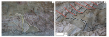
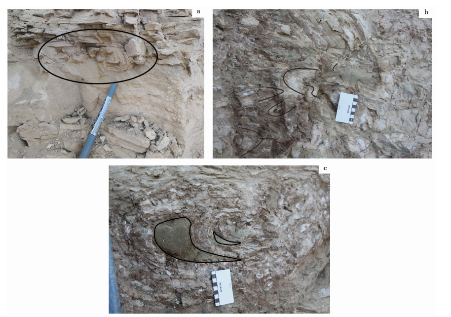
剖面Ⅲ (26.229 147° N, 100.504 956° E; 海拔1 280m)位于下力农村东侧半坡处(图 2), 是研究区内发现的海拔最低的软沉积变形构造剖面。 剖面中的变形层厚约7m, 下部未完全揭露, 该剖面的黏土层与砂层均发生了强烈的破碎与弯曲变形(图5a), 形成了大量黏土团块与砂团块(图5b, c)。 黏土层的厚度变化较大, 且已破裂变形成多段, 分布较为杂乱, 有大段黏土层断块孤立分布于砂体中(图5d)。
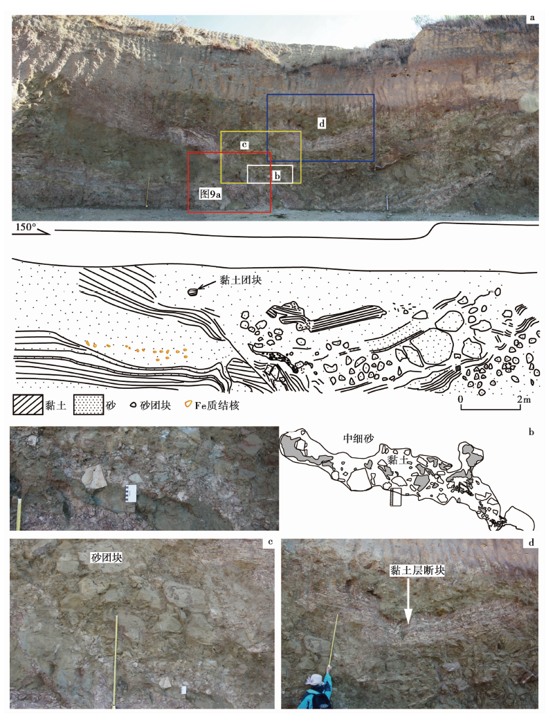 | 图 5 永胜县涛源镇剖面Ⅲ 照片与剖面图 a 剖面Ⅲ 的整体照片与素描图; b 黏土团块的照片与素描图; c 砂团块(尺长1m); d 黏土层断块(尺长1m)Fig. 5 Photos and cross section diagrams of profile Ⅲ in Taoyuan Town, Yongsheng County. |
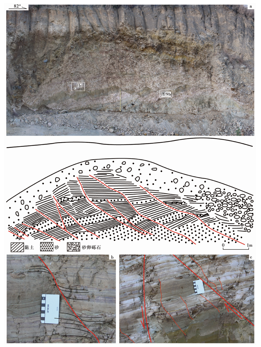
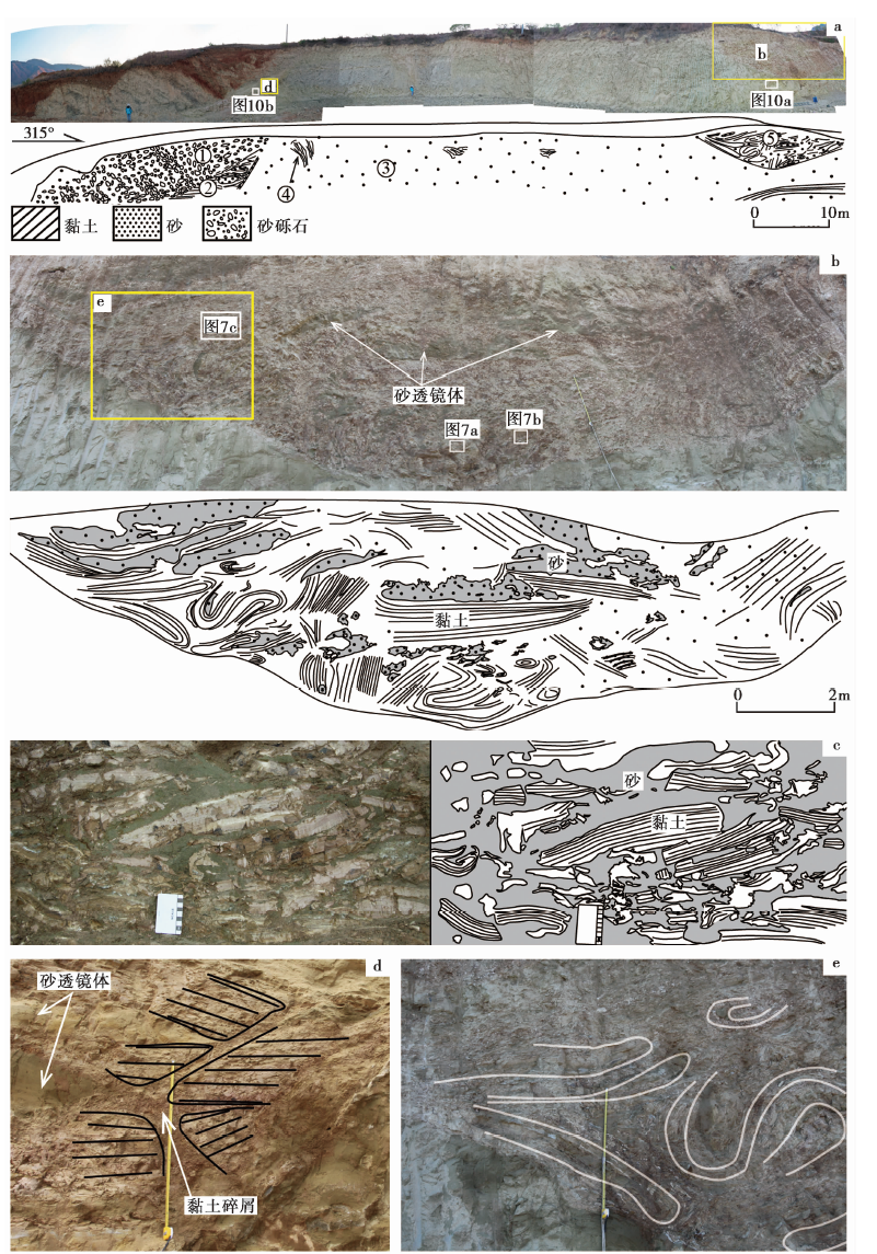
剖面Ⅳ (26.237 231° N, 100.504 302° E; 海拔1 400m)位于下力农村东侧脊部, 其海拔与剖面Ⅰ 相近, 长约120m, 剖面最高处约10.5m(图6a)。 该剖面湖相地层的主体为灰黄色中细砂③, 无层理发育, 中间混有少量黏土碎屑④, 黏土层②和⑤分布在砂体③的两端, 砂体③的左侧边界与黏土层②及上部砂砾石层接触, 接触面为一层厚约10cm的钙结砂岩, 左侧上部与砂砾石层①接触。 黏土层②中含有多个砂透镜体, 该层分裂成多组产状不同的黏土层块, 各黏土层块的接触处形成了黏土层碎屑带(图6d)。 黏土层⑤中发育有大量褶曲、 砂透镜体构造(图6b), 上侧与右侧主要发育砂透镜体与黏土团块构造(图6c), 黏土层脆性变形强烈, 左下侧以大量的塑性褶曲变形构造为主, 褶曲构造密集分布(图6e)。
 | 图 6 永胜县涛源镇剖面Ⅳ 照片与剖面图 a 剖面Ⅳ 的整体照片与剖面图; b 剖面右侧黏土强变形区的照片与素描图; c 黏土破碎团块; d 不同产状黏土层接触带的黏土碎屑(卷尺长1m); e 黏土层的褶曲组合(卷尺长1m)Fig. 6 Photos and cross section diagrams of profile Ⅳ in Taoyuan Town, Yongsheng County. |
在剖面Ⅰ — Ⅳ (图 3— 6)中均发现存在砂层液化、 无根断层、 黏土团块、 褶曲、 负载、 火焰构造、 肿缩构造等变形构造现象。 下面将针对这些变形分别进行描述。
2.2.1 液化砂层
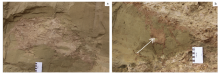
软沉积变形构造发育的剖面中均有厚— 巨厚层的中细砂层, 剖面Ⅳ 中的砂层最厚可达9.5m, 虽然剖面间存在一定的距离, 但每条剖面中的这套厚层砂层均为灰黄色中细砂层, 层内未见层理发育, 其内含黏土碎屑、 黏土团块(图5b, 图6a中的④), 甚至大块的黏土层断块(图5d), 且可见黏土碎屑、 团块与砂的液化混搅体(图5b)。 黏土层在其与砂层接触带处出现破碎残缺并褶曲变形(图3d), 且在研究剖面中发现有明显的流砂通道(图7a, b)。 根据以上特征, 分析认为研究剖面中的这套灰黄色中细砂层均发生了不同程度液化。 其中, 剖面Ⅳ 中的砂层在剖面中出露呈不规则形状, 砂层中未见层理, 且在砂层中的不同层位均发现有被包裹的黏土碎屑、 团块(图6a中的④, 图 8), 说明该剖面砂体曾发生液化作用, 该剖面砂层也是研究区内发现的出露最厚的液化砂层。
 | 图 7 剖面中的流砂通道照片 a 剖面Ⅲ 中黏土层间的流砂通道(尺长1m); b 剖面Ⅱ 中的砂层液化通道及上覆黏土层形成的微断层Fig. 7 Photos of sand flow channel in the profile. |
 | 图 8 剖面Ⅵ 中包裹于液化砂层中的黏土碎屑团Fig. 8 Clay clastic mass involved in the land layer of profile Ⅵ . |
2.2.2 无根断层构造
软沉积变形构造剖面Ⅰ 、 Ⅱ 内均有多条断层发育, 断层分布密集, 同一剖面中的断层产状相近, 但2条剖面之间断层产状、 断距及断层密度差异均较大, 应不属于同一组断层。 断层构造仅发育在湖相沉积物中, 未延续到上覆的砂砾石层或耕植土中。 剖面Ⅰ 中的断层清晰错断黏土层, 但未见断层有滑动面, 3条主要断层F1、 F2、 F3表现为由黏土碎屑、 团块与砂混合的断层破碎带(图3c), 仅断层F2向下延续至砂层, 在砂层中延续的长度约为1m, 其它断层在下部砂层中均未见有延续。 断层F4向下延伸至黏土层间夹的砂层, 砂层被断层部分错断, 并在断层两盘出现厚度变化(图 10)。 部分断层的断距变化较大, 如剖面Ⅱ 中的断层向上延伸1m则断距减小超过一半(图4a)。
 | 图 9 剖面Ⅳ 中小型褶曲的照片Fig. 9 Photos of middle and small folds in profile Ⅳ . |
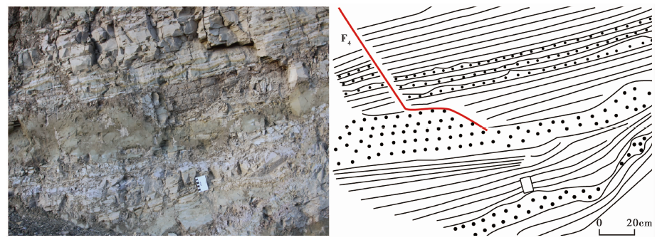 | 图 10 剖面Ⅰ 中断层F4的照片与素描图Fig. 10 Photo and sketch of F4 in profile I. |
2.2.3 液化砂层中的团块构造
研究剖面中含有大量黏土与砂团块, 黏土团块多分布于黏土层与砂层的接触带或断层破碎带处, 部分砂体中含有独立的黏土团块或黏土碎屑团(图5b, 6c), 黏土团块的粒径从几mm至几十cm不等, 断层破碎带处的团块相对较小, 粒径多< 1cm, 在砂层中偶见粒径为数十cm砂团(图5b)。 砂团块主要分布在剖面Ⅲ 中, 直径最大可达1.2m, 较小的直径仅几cm, 其固结程度明显高于周围支撑填隙的砂体, 颜色较周围偏灰(图5c), 部分相邻团块的边界具有可拼合性。
2.2.4 褶曲构造
褶曲构造在剖面Ⅱ 、 Ⅲ 和Ⅳ 中均有分布, 在剖面Ⅳ 中最为发育, 剖面Ⅱ 中的褶曲构造主要为分布在断层两侧的由牵引作用形成的牵引褶曲构造, 具有明显的摩擦牵引特征(图 4b)。 剖面Ⅲ 与Ⅳ 中的褶曲构造均发育在黏土层与砂层强力变形处, 剖面Ⅲ 中的褶曲构造相对宽缓, 黏土层的弯曲变形多伴随有厚度变化。 剖面Ⅳ 中的褶曲构造集中分布, 褶曲类型主要为紧闭褶曲, 且存在多个褶曲构造集中组合在一起形成的复杂揉皱, 褶曲轴面的产状无定向性(图6e), 在大褶曲间又发育了仅几cm或十几cm的微褶曲(图9a, b), 在黏土层的褶曲转折端有砂体沿层间虚脱处充填(图9c)。
下面将通过剖面中软沉积变形构造的特征、 地层岩性和气候地貌条件, 结合该区的构造地质背景等对这些软沉积变形构造的成因及触发因素进行分析。
无根断层构造向下的延伸均终止于下部的液化砂层, 剖面Ⅰ 中的断层F4未完全切穿下部黏土层中所夹的砂层, 终止于砂层内部。 砂层在断层两侧的厚度发生明显变化, 且如上文所述, 剖面中的砂层发生了液化变形, 结合以上断层特征, 分析认为此类断层的形成主要是由于砂层的液化作用所致。 虽然在剖面Ⅱ 中断层未暴露厚层的液化砂层, 但在该剖面斜下方5m处另一剖面中发现了厚层的灰黄色中细砂层, 其上部与黏土层混搅, 说明该砂层也曾出现较强的液化现象, 在该剖面中黏土层间所夹的中厚层砂层中也可见小规模的液化现象, 且在液化砂层上部的黏土层中形成了一系列微断层(图7b)。 根据以上断层特征, 认为研究剖面中的断层是由于黏土层下伏的砂层发生砂土液化作用导致其下部支撑力失稳而形成的。
前人在岩石地层的软沉积变形构造研究中将与研究剖面中黏土团块相似的构造命名为液化角砾构造, 其特征是液化的砂体充填在棱角状的震碎的泥岩角砾之间(田洪水等, 2016)。 液化角砾的形成多是由于在强烈震动作用下脆性的黏土层发生震裂, 与震裂的黏土层相邻的液化砂层沿黏土层的裂隙挤入填充, 并将黏土层逐渐裂解。 研究剖面中的黏土团块虽还未成岩, 但其在成因上与液化角砾相同, 是未固结的黏土层在下伏液化砂层的作用下发生裂解而形成的, 团块间被液化的砂体分隔。 处于半固结状态的砂层因固结程度存在差异, 在强烈的外力作用下部分砂层发生了液化作用, 固结程度较高的砂层在振动作用下发生了破碎, 液化作用优先沿破裂面发生, 或液化砂层沿破裂面挤入砂层, 由此使部分液化不完全的砂层形成砂团块。
软沉积变形构造中的褶曲构造多是由于未固结的软沉积层受到外力挤压而成(苏德辰等, 2011), 但剖面Ⅳ 中的褶曲变形程度强烈, 且褶曲轴面的产状无定向性, 多个大小褶曲构成了复杂的褶皱组合。 该黏土层未发生褶皱的部分呈破碎状并形成了黏土团块, 在褶皱之间也可见大量液化砂层充填, 且该套黏土层与巨厚的液化砂层相邻。 根据上述特征分析认为, 剖面Ⅳ 中发育的褶曲并非简单地因挤压作用而成, 而是下伏砂层发生液化或流化导致上覆黏土层发生了一系列复杂的挤压揉皱作用而形成的。
饱水的砂层由砂颗粒组成松散的骨架, 颗粒间充满了孔隙水, 其稳定性主要靠颗粒间的摩擦力来维持。 当受到外力作用时, 由于砂体颗粒抗拉剪强度很低, 颗粒产生位移, 改变砂层颗粒原有的排列结构, 使颗粒间趋于密实, 导致孔隙水压力增大, 发生液化作用(冯先岳, 1989)。 砂层比黏土层的孔隙度更大、 粘结度更小、 颗粒排列的稳定性差。 当饱水地层所处应力环境发生改变时, 砂层颗粒的排列方式易被打破。 因此, 在外力作用尤其是地震振动作用的影响下, 砂层易发生液化作用, 而黏土层则相对更加稳定。 发生液化的砂层在上覆地层压力或自身重力的驱动下发生流动, 并驱使相邻较稳定地层发生一系列的变形作用。 研究剖面中, 黏土层变形构造的周围均伴有砂层液化现象, 砂层的变形最为强烈, 且黏土层多以脆性变形方式为主。 结合上述变形构造成因分析, 认为液化砂层是研究剖面中软沉积变形构造的主要驱动地层, 黏土层形成的变形构造多为液化砂层驱动的被动变形构造。 砂层的液化变形厚度和强弱决定了上覆黏土层的变形程度。
软沉积变形的触发因素主要可通过标准判定法、 沉积学与古环境综合分析2种方法进行识别。 目前, 研究者往往将2种方法结合, 排除不可能的触发因素, 分析可能的触发因素(Jones et al., 2000; Moretti, 2000; Moretti et al., 2007; Spalluto et al., 2007; Garcia-Tortosa et al., 2011; Gibert et al., 2011; Owen et al., 2011; Rossetti et al., 2011)。 下文将主要根据软沉积变形的特征, 结合沉积环境与构造背景分析研究剖面中软沉积变形的触发因素。
研究剖面位于金沙江峡谷的左岸, 即金沙江的凸岸侧, 属于弯道沉积区。 此处金沙江的流向由SSE转为E, 发生了近90° 的大转弯(图 2)。 剖面西侧SSW向的山脊阻挡了金沙江强水动力对研究剖面的冲刷作用。 研究剖面中的黏土层水平层理发育, 也反映了该处稳定的静水沉积环境。 在静水湖泊沉积环境中湖面波浪对湖底沉积物的扰动影响较小。 根据野外剖面地层对比, 研究剖面中的地层为同期湖泊沉积地层, 而变形剖面之间高差达100m以上, 说明剖面Ⅲ 在沉积时上覆水深可能超过100m, 在此水深处也可排除湖泊波浪作用的影响。
金沙江流域常出现洪水事件, 但在研究区软沉积变形层的上部未见覆盖或残留有洪积层而是砂卵石层、 坡积物或耕植土。 在剖面Ⅳ 与砂砾石层接触的液化砂层中未见有砾石卷入, 却有多处黏土碎屑混入, 砾石的比重大于砂和黏土, 若为液化变形时沉积, 则沉积物不可能完全不卷入液化砂体中, 故可认为这套砂砾石层的沉积时间应在液化变形作用之后。 水流作用引起的变形深度较浅, 多以小型卷曲为主(Rana et al., 2016; 钟建华等, 2019), 而研究剖面上液化变形的深度可达9.5m以上, 变形构造以大规模无根断层与黏土团块及褶曲构造为主。 由此分析, 冲、 洪积事件不是引起此次变形的主要触发因素。
滑塌构造是未固结沉积物在重力作用下沿斜坡向下滑动所产生的一系列褶曲, 有时伴生有断层构造(冯先岳, 1989)。 滑塌体前缘常形成大量褶曲构造(Du et al., 2005; 苏德辰等, 2013), 滑塌引起变形的程度向滑塌体前缘逐渐增强。 滑坡作用形成软沉积变形构造主要因沉积物在自身重力作用下发生滑动变形, 或沉积区附近的基岩发生滑坡时滑坡体滑入沉积物中挤压而形成的。 滑坡体滑入形成的软沉积变形构造主要为挤压构造, 与研究剖面中大量的正断层构造反映的拉张应力场不同, 且在变形地层中未发现存在滑坡体, 研究区后缘的山坡亦无滑坡存在的痕迹, 故可排除滑坡侵入挤压的可能。 研究区内拉张变形构造与挤压变形构造的分布不具有递变特征, 且构造变形的强度与其所处位置无相关性, 与滑塌作用的应力特征不同。 根据上文的分析, 研究区的断层构造是由下伏砂层液化所致, 并非为滑塌体后缘的伸展断层。 滑塌的形成需要具备斜坡沉积重力不稳的条件, 但此研究区内湖相地层分布的水平高差达数百m, 软沉积变形层位于湖相沉积层的上部, 其下伏为产状近水平的湖相地层, 在这种环境下地层不易在自身重力驱动下发生滑塌。 综合上述多方面对比分析可知, 滑塌作用与周围基岩滑坡事件不可能是研究区软沉积变形的主要触发因素, 但不排除在液化时局部发生小型地层滑塌影响软沉积变形构造的可能性。
在软沉积变形层上未发现有冰碛物或火山物质, 且研究剖面的海拔最高仅为1 420m, 不可能发生大规模的冻融作用。 综上, 可排除研究剖面的变形构造由冰川作用、 火山喷发、 冻融作用触发的可能。
地震作用是引起软沉积物液化变形的最常见的触发因素。 在较大地震发生时, 强烈的振动作用会导致未固结、 饱水的砂土层发生液化(冯先岳, 1989)。 此前有报道称昔格达组内发育有大量由地震作用引起的褶曲和无根阶梯断层等构造(李玶等, 1985; 许述礼, 1990)。 研究剖面处于构造活跃区, 地震活动是触发研究区软沉积变形的重要因素。 当地震触发砂土液化时, 砂层是主要液化层, 液化砂层的厚度与液化规模呈正相关, 液化规模增大, 则其上覆未液化地层的变形也随之增强。 在本文的研究剖面中, 地层变形的强度与砂层厚度具有明显的相关性。 位于下力农村东侧脊部的剖面Ⅳ 为研究区内出露的最大的软沉积变形构造剖面, 剖面长约120m, 高度超过10m, 主体为砂层, 是砂层在剖面地层中占比最大的剖面, 而此剖面是上覆湖相黏土层变形最为强烈的剖面(图9a— c), 出现了平卧紧闭褶皱组合、 黏土团块和砂透镜等强烈挤压震动的变形结构。 研究区的地质背景与剖面地层的软沉积变形特征皆指示地震作用是研究剖面中软沉积变形的触发因素。
前人的研究认为, 能够产生砂土液化的地震至少应为5级(Rodrí guez-Pascua et al., 2000; Tian et al., 2014; 钟宁, 2017)。 由于地震强度与地层液化程度的关系受砂层厚度、 地下水位深度、 地层岩性和固结程度等多种因素影响, Rodrí guez-Pascua等(2003)通过统计分析提出了地震震级(M)与地震扰动层厚度(T)的经验公式: M=T/3+3.83。 本研究剖面中揭露的最大液化层厚9.5m, 且顶底未见非液化层, 说明最大液化厚度≥ 9.5m, 根据此经验公式可得震级≥ 7。 研究剖面的液化砂层中有大量黏土团块, 根据前文所述可知, 黏土团块构造与岩石地层中的液化角砾构造的成因相同, 而液化角砾构造是在强震条件下形成的(Rodrí guez-Pascua et al., 2000), Berra等(2011)认为震裂角砾对应的震级应为7~8级。 综合上述分析认为, 研究区内的软沉积变形构造可能是1次7级以上的古强震所造成的。
根据研究区地质背景与变形特征综合分析, 本文研究剖面中的变形构造主要是由地震触发。 结合研究剖面的软沉积变形构造特征可知, 地震触发的软沉积变形构造具有以下特征:
由地震砂土液化形成的软沉积变形构造, 在地层特征上须具备饱水的未固结砂层。 本研究中, 砂层厚度最大的2条剖面的变形程度最为强烈, 结合地震液化的特点, 认为地震液化产生的软沉积的变形程度不仅受到地震强度的影响, 地层中易液化砂层的厚度同样是决定其变形程度的关键, 液化砂层厚度越大则软沉积变形越强烈。
地震的振动作用引起的砂层液化通常变形范围较大, 在地震波及范围内的具备液化条件的砂层皆会产生一定程度的液化作用, 且地震振动作用影响的地层深度较大, 因此在易液化砂层厚度大且水平延伸距离远的情况下, 地震作用可引起大范围的强烈液化变形。 而河湖水动力、 重力均衡作用引起的液化作用规模一般较小, 变形程度较弱。
研究区内剖面中的变形构造混乱, 各剖面的变形构造无法进行延伸对比, 这主要是由于地震引起的液化变形构造较为复杂, 没有明显的受力方向。 而冰川、 水流牵引等由表面作用力或重力牵引下形成的软沉积变形构造多受主牵引力方向的影响, 往往会形成优势变形方向。
剖面中因地震液化形成的断层构造、 黏土团块、 褶曲构造虽与滑塌作用形成的变形构造类型上具有相似性, 但其变形特征存在差异。 滑塌作用主要是在重力驱动下地层向下发生滑动, 因此滑塌体后缘至前缘的变形程度具有传递性。 由于地层下滑, 滑坡体后缘将发生张性变形, 形成一系列张性浅表断层构造, 滑坡前缘则由于地层挤压造成挤压变形, 将形成以褶曲与破碎为主的变形构造。 而地震液化形成的变形构造多数较为复杂, 无明显的变形规律。 地震液化作用形成的断层是由于砂层液化导致的上部地层错断, 该类断层根源于液化砂层, 液化砂层在断层的两盘厚度存在差异。 滑塌体的前缘由于受挤压作用可形成系列轴面产状相近的褶曲组合, 褶曲的轴面产状则反映一定的力学方向。 地震液化形成的褶曲组合均为复杂的揉皱变形, 各褶曲的形态与分布无规律, 没有明显的受力方向(乔秀夫等, 2008)。
综上所述, 永胜县昔格达组中存在大量的软沉积变形构造, 典型的软沉积变形构造有液化砂层、 无根断层、 团块和褶曲等。 该地层的变形强烈、 规模巨大, 且变形剖面皆与液化砂层有关。 分析软沉积变形构造的特征可知, 研究剖面中的软沉积变形构造主要由液化砂层驱动形成。
根据研究区的地质背景与研究剖面的地层变形特征, 排除了研究剖面的变形构造是由洪水、 波浪、 滑塌等作用触发的可能性, 认为该变形是由1次震级较大的古地震事件触发。 根据前人关于变形构造对应震级的相关研究, 推测此次古地震的震级为7级以上。
地震触发的大规模软沉积变形构造剖面中均存在液化砂层, 且地层具有 “ 二元结构” , 即下部为砂层和上部为黏土层。 下伏砂层的厚度和变形强度决定上覆黏土层变形构造的强度。 地震形成的变形构造主要有地层错位、 无根断层、 砂层挤入、 砂层管道、 复杂褶曲、 黏土团块、 负载构造、 火焰构造和肿缩构造等, 变形构造式样复杂, 无明显的变形规律, 且变形规模可能很大且较为强烈。
致谢 本研究的野外工作得到了云南省地震局常峰祖研究员的指导; 审稿专家为本文提出了细致的修改建议, 使本文得到进一步完善。 在此一并表示感谢!
| [1] |
|
| [2] |
|
| [3] |
|
| [4] |
|
| [5] |
|
| [6] |
|
| [7] |
|
| [8] |
|
| [9] |
|
| [10] |
|
| [11] |
|
| [12] |
|
| [13] |
|
| [14] |
|
| [15] |
|
| [16] |
|
| [17] |
|
| [18] |
|
| [19] |
|
| [20] |
|
| [21] |
|
| [22] |
|
| [23] |
|
| [24] |
|
| [25] |
|
| [26] |
|
| [27] |
|
| [28] |
|
| [29] |
|
| [30] |
|
| [31] |
|
| [32] |
|
| [33] |
|
| [34] |
|
| [35] |
|
| [36] |
|
| [37] |
|
| [38] |
|
| [39] |
|
| [40] |
|
| [41] |
|
| [42] |
|
| [43] |
|
| [44] |
|
| [45] |
|
| [46] |
|
| [47] |
|
| [48] |
|
| [49] |
|
| [50] |
|