
SEISMOLOGY AND EGOLOGY ›› 2021, Vol. 43 ›› Issue (4): 739-756.DOI: 10.3969/j.issn.0253-4967.2021.04.001
• Research paper • Previous Articles Next Articles
THE DEEP STRUCTURAL CHARACTERISTICS AND THE SEIS-MOGENIC STRUCTURE OF THE YANGBI EARTHQUAKE REGION AND ITS SURROUNDING AREAS
WU Gui-ju1,3)( ), YU Bing-fei2), HAO Hong-tao1,3), HU Min-zhang1,3), TAN Hong-bo1)
- 1) Key Laboratory of Earthquake Geodesy, Institute of Seismology, CEA, Wuhan 430071, China
2) Central South Institute of Geological Survey, China Metallurgical Geology Bureau, Wuhan 430081, China
3) Hebei Key Laboratory of Earthquake Dynamics, Institute of Disaster Prevention, Sanhe, Hebei 065201, China
-
Received:2021-06-08Revised:2021-06-23Online:2021-08-20Published:2021-09-29
漾濞震区及周缘深部构造特征与发震构造
吴桂桔1,3)(), 于炳飞2), 郝洪涛1,3), 胡敏章1,3), 谈洪波1)
- 1)中国地震局地震研究所, 地震大地测量重点实验室, 武汉 430071
2)中国冶金地质总局中南地质调查院, 武汉 430081
3)防灾科技学院, 河北省地震动力学重点实验室, 三河 065201
-
作者简介:吴桂桔, 女, 1983年生, 2012年于中国地质大学(武汉)获地球探测与信息技术专业博士学位, 副研究员, 主要从事综合地球物理场解释与重力学科地震会商工作, E-mail: wugjsky@126.com。 -
基金资助:中国地震局地震科技星火计划项目(XH21021);国家自然科学基金(42074127);国家自然科学基金(41774015)
CLC Number:
Cite this article
WU Gui-ju, YU Bing-fei, HAO Hong-tao, HU Min-zhang, TAN Hong-bo. THE DEEP STRUCTURAL CHARACTERISTICS AND THE SEIS-MOGENIC STRUCTURE OF THE YANGBI EARTHQUAKE REGION AND ITS SURROUNDING AREAS[J]. SEISMOLOGY AND EGOLOGY, 2021, 43(4): 739-756.
吴桂桔, 于炳飞, 郝洪涛, 胡敏章, 谈洪波. 漾濞震区及周缘深部构造特征与发震构造[J]. 地震地质, 2021, 43(4): 739-756.
share this article
Add to citation manager EndNote|Ris|BibTeX
URL: https://www.dzdz.ac.cn/EN/10.3969/j.issn.0253-4967.2021.04.001
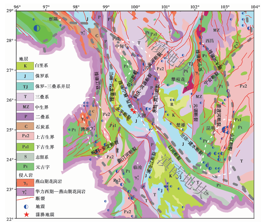
Fig. 1 Simple tectonic geological map of the study area(after DENG Qi-dong et al., 2007).
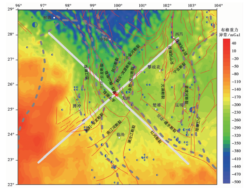
Fig. 2 Bouguer gravity anomalies, faults and earthquakes distribution.
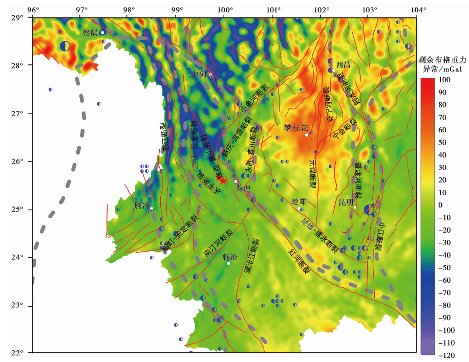
Fig. 3 Residual Bouguer gravity anomalies, faults and earthquakes distribution.
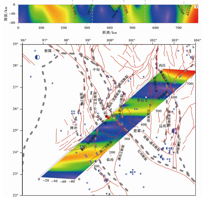
Fig. 4 Normalized gradient image of the NE gravity profile in Yangbi earthquake region.
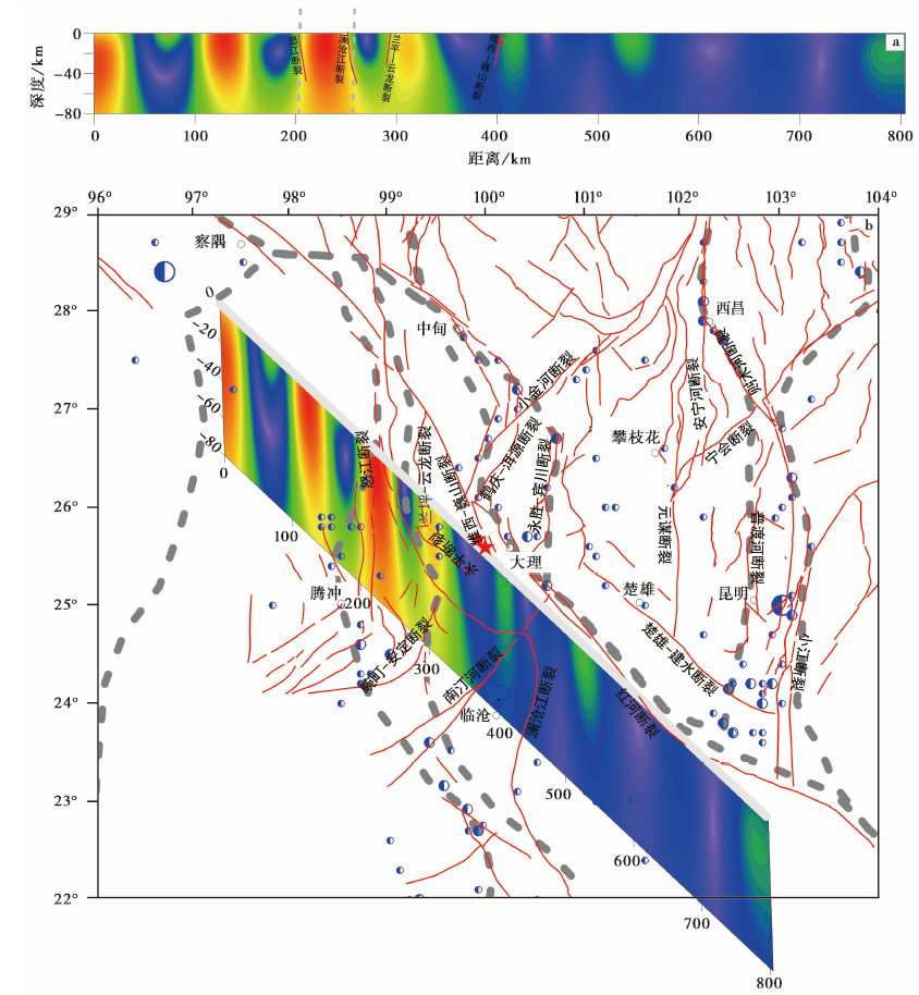
Fig. 5 Normalized gradient image of the NW gravity profile in Yangbi earthquake region.
| 断层名称 | 倾向 | 倾角 |
|---|---|---|
| 澜沧江断裂 | SW | 60°~70° |
| 兰坪-云龙断裂 | SW | >60° |
| 红河断裂北段 | SW | >60° |
| 永胜-宾川断裂 | W | 近90° |
| 维西-巍山断裂 | NE | >50° |
| 怒江断裂南段 | NW | >50° |
| 则木河断裂 | NE | 60°~70° |
| 雄楚-建水断裂 | SW | 70° |
Tabel 1 Major faults information
| 断层名称 | 倾向 | 倾角 |
|---|---|---|
| 澜沧江断裂 | SW | 60°~70° |
| 兰坪-云龙断裂 | SW | >60° |
| 红河断裂北段 | SW | >60° |
| 永胜-宾川断裂 | W | 近90° |
| 维西-巍山断裂 | NE | >50° |
| 怒江断裂南段 | NW | >50° |
| 则木河断裂 | NE | 60°~70° |
| 雄楚-建水断裂 | SW | 70° |
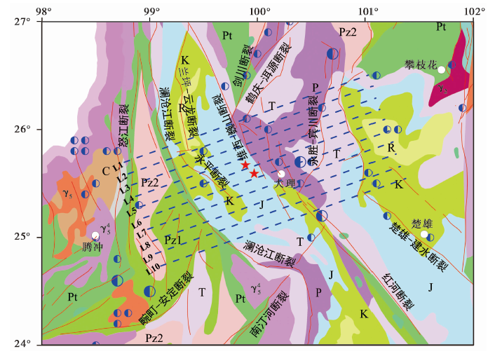
Fig. 6 Diagram of gravity profiles distribution and geological structure in Yangbi seismic area and adjacent area.
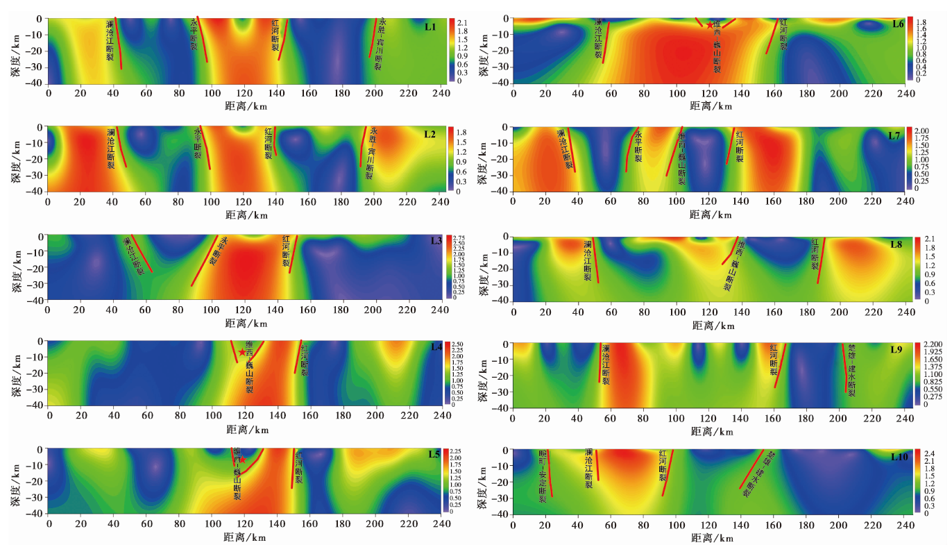
Fig. 7 Normalized gradient images of the 10 gravity profiles in Yangbi earthquake region.
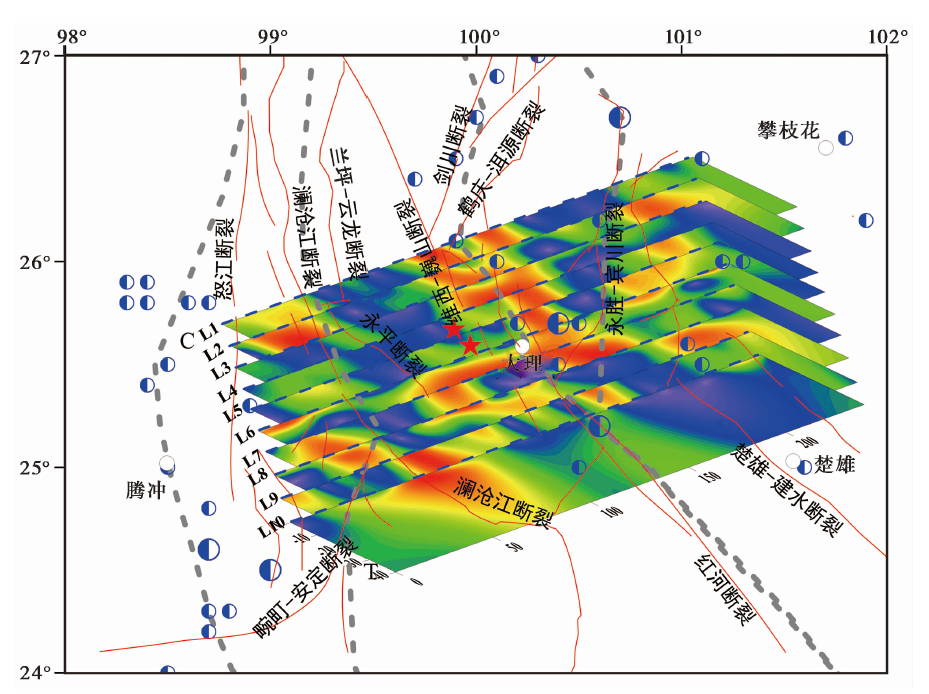
Fig. 8 3-D normalized gradient image in Yangbi earthquake region.
| [1] | 白志明, 王椿镛. 2004. 云南遮放-宾川和孟连-马龙宽角地震剖面的层析成像研究[J]. 地球物理学报, 47(2): 257-267. |
| BAI Zhi-ming, WANG Chun-yong. 2004. Tomography research of the Zhefang-Binchuan and Menglian-Malong wide-angle seismic profiles in Yunnan Province[J]. Chinese Journal of Geophysics, 47(2): 257-267. (in Chinese) | |
| [2] | 邓起东, 张培震, 冉勇康, 等. 2003. 中国活动构造与地震活动[J]. 地学前缘, 10(8): 66-73. |
| DENG Qi-dong, ZHANG Pei-zhen, RAN Yong-kang, et al. 2003. Active tectonics and earthquake activities in China[J]. Earth Science Frontiers, 10(8): 66-73. (in Chinese) | |
| [3] | 邓起东, 冉勇康, 杨晓平, 等. 2007. 中国活动构造图[M]. 北京: 地质出版社. |
| DENG Qi-dong, RAN Yong-kang, YANG Xiao-ping, et al. 2007. Active Tectonics Map of China[M]. Seismological Press, Beijing. (in Chinese) | |
| [4] | 方盛明, 赵成彬, 柴炽章, 等. 2009. 银川断陷盆地地壳结构与构造的地震学证据[J]. 地球物理学报, 52(7): 1768-1775. |
| FANG Sheng-ming, ZHAO Cheng-bin, CHAI Chi-zhang, et al. 2009. Seismic evidence of crustal structures in the Yinchuan faulted basin[J]. Chinese Journal of Geophysics, 52(7): 1768-1775. (in Chinese) | |
| [5] | 郭飚, 刘启元, 陈九辉, 等. 2009. 川西龙门及邻区地壳上地幔远震P波层析成像[J]. 地球物理学报, 52(2): 346-355. |
| GUO Biao, LIU Qi-yuan, CHEN Jiu-hui, et al. 2009. Teleseismic P-wave tomography of the crust and upper mantle in Longmenshan area, west Sichuan[J]. Chinese Journal of Geophysics, 52(2): 346-355. (in Chinese) | |
| [6] | 郝天珧, 江为为, 胥颐, 等. 2005. 红河断裂带研究区深部结构特点的地球物理研究[J]. 地球物理学进展, 20(3): 584-593. |
| HAO Tian-yao, JIANG Wei-wei, XU Yi, et al. 2005. Geophysical research on deep structure feature in study region of Red River fault zone[J]. Progress in Geophysics, 20(3): 584-593. (in Chinese) | |
| [7] | 黄金莉, 宋晓东, 汪素云. 2003. 川滇地区上地幔顶部Pn速度细结构[J]. 中国科学(D辑), 33(S1): 144-151. |
| HUANG Jin-li, SONG Xiao-dong, WANG Su-yun. 2003. The Pn velocity structure of upper mantle in Sichuan-Yunnan region[J]. Science in China(Ser D), 33(S1): 144-151. (in Chinese) | |
| [8] | 李昱, 姚华建, 刘启元, 等. 2010. 川西地区台阵环境噪声瑞利波相速度层析成像[J]. 地球物理学报, 53(4): 842-852. |
| LI Yu, YAO Hua-jian, LIU Qi-yuan, et al. 2010. Phase velocity array tomography of Rayleigh waves in western Sichuan from ambient seismic noise[J]. Chinese Journal of Geophysics, 53(4): 842-852. (in Chinese) | |
| [9] | 马宏生, 张国民, 闻学泽, 等. 2008. 川滇地区三维P波速度结构反演与构造分析[J]. 地球科学, 33(5): 591-602. |
|
MA Hong-sheng, ZHANG Guo-ming, WEN Xue-ze, et al. 2008. 3-D P wave velocity structure tomographic inversion and its tectonic interpretation in southwest China[J]. Earth Science-Journal of China University of Geosciences, 33(5): 591-602. (in Chinese)
DOI URL |
|
| [10] | 唐伯熊, 吴国华. 1991. 重力测量研究断裂活动的尝试[J]. 地震, 6:73-76. |
| TANG Bo-xiong, WU Guo-hua. 1991. Fault activity study by gravimetry[J]. Earthquake, 6:73-76. (in Chinese) | |
| [11] | 唐伯熊, 吴国华, 罗剑寒. 1990. 红河断裂带上的重力测量[J]. 地震研究, 13(3): 273-276. |
| TANG Bo-xiong, WU Guo-hua, LUO Jian-han. 1990. Gravity measurement along Red River fault zone[J]. Journal of Seismological Research, 13(3): 273-276. (in Chinese) | |
| [12] | 滕吉文, 司芗, 王谦身, 等. 2015. 青藏高原地球科学研究中的核心问题与理念的厘定[J]. 地球物理学报, 58(1): 103-124. |
| TENG Ji-wen, SI Xiang, WANG Qian-shen, et al. 2015. Collation and stipulation of the core science problems and theoretical concept in the geoscience study on the Tibetan plateau[J]. Chinese Journal of Geophysics, 58(1): 103-124. (in Chinese) | |
| [13] | 滕吉文, 王谦身, 王光杰, 等. 2006. 喜马拉雅 “东构造结”地区的特异重力场与深部地壳结构[J]. 地球物理学报, 49(4): 1045-1052. |
| TENG Ji-wen, WANG Qian-shen, WANG Guang-jie, et al. 2006. Specific gravity field and deep crustal structure of the “Himalayas east structural knot”[J]. Chinese Journal of Geophysics, 49(4): 1045-1052. (in Chinese) | |
| [14] | 吴桂桔, 谈洪波, 孙凯, 等. 2020. 贺兰山-银川地堑及邻区重力异常特征及构造意义[J]. 地球物理学报, 63(3): 1002-1013. |
| WU Gui-ju, TAN Hong-bo, SUN Kai, et al. 2020. Characteristics and tectonic significance of gravity anomalies in the Helanshan-Yinchuan graben and adjacent areas[J]. Chinese Journal of Geophysics, 63(3): 1002-1013. (in Chinese) | |
| [15] | 徐涛, 张明辉, 田小波, 等. 2014. 丽江-清镇剖面上地壳结构及其与鲁甸MS6.5地震孕震环境的关系[J]. 地球物理学报, 57(9): 3069-3079. |
| XU Tao, ZHANG Ming-hui, TIAN Xiao-bo, et al. 2014. Upper crustal velocity of Lijiang-Qingzhen profile and its relationship with the seismogenic environment of the MS6.5 Ludian earthquake[J]. Chinese Journal of Geophysics, 57(9):3069-3079. (in Chinese) | |
| [16] | 徐锡伟, 张培震, 闻学泽, 等. 2005. 川西及邻近地区活动构造基本特征与强震复发模型[J]. 地震地质, 27(3): 446-461. |
| XU Xi-wei, ZHANG Pei-zhen, WEN Xue-ze, et al. 2005. Features of active tectonics and recurrence behaviors of strong earthquake in the western Sichuan Province and its adjacent regions[J]. Seismology and Geology, 27(3): 446-461. (in Chinese) | |
| [17] | 杨文采, 孙艳云, 于常青. 2015. 青藏高原地壳密度变形带及构造分区[J]. 地球物理学报, 58(11): 4115-4128. |
| YANG Wen-cai, SUN Yun-yan, YU Chang-qing. 2015. Crustal density of deformation zones of Qinghai-Tibet Plateau and their geological implications[J]. Chinese Journal of Geophysics, 58(11): 4115-4128. (in Chinese) | |
| [18] | 詹艳, 赵国泽, 王继军, 等. 2005. 青藏高原东北缘海原弧形构造区地壳电性结构探测研究[J]. 地震学报, 27(4): 431-440. |
| ZHAN Yan, ZHAO Guo-ze, WANG Ji-jun, et al. 2005. Crustal electric structure of Haiyuan arcuate tectonic region in the northeastern margin of Qinghai-Xizang Plateau, China[J]. Acta Seismologica Sinica, 27(4): 431-440. (in Chinese) | |
| [19] | 张健, 石耀霖. 2002. 青藏高原隆升及伸展变形中的重力位能[J]. 地球物理学报, 45(2): 226-232. |
| ZHANG Jian, SHI Yao-lin. 2002. The role of gravitational potential energy in raising and spreading of Qinghai-Xizang Plateau[J]. Chinese Journal of Geophysics, 45(2): 226-232. (in Chinese) | |
| [20] | 张培震, 邓起东, 张国民, 等. 2003. 中国大陆的强震活动与活动地块[J]. 中国科学(D辑), 33(S1): 12-20. |
| ZHANG Pei-zhen, DENG Qi-dong, ZHANG Guo-min, et al. 2003. Active tectonic blocks and strong earthquakes in the continent of China[J]. Science in China(Ser D), 33(S1): 12-20. (in Chinese) | |
| [21] | 张燕, 程顺有, 赵炳坤, 等. 2013. 青藏高原构造结构特点: 新重力异常成果的启示[J]. 地球物理学报, 56(4): 1369-1380. |
| ZHANG Yan, CHENG Shun-you, ZHAO Bing-kun, et al. 2013. The feature of tectonics in the Tibet Plateau from new regional gravity signals[J]. Chinese Journal of Geophysics, 56(4): 1369-1380. (in Chinese) | |
| [22] | 张忠杰, 白志明, 王椿镛, 等. 2005. 三江地区地壳结构及动力学意义: 云南遮放-宾川地震反射/折射剖面的启示[J]. 中国科学(D辑), 35(4): 314-319. |
| ZHANG Zhong-jie, BAI Zhi-ming, WANG Chun-yong, et al. 2005. The crustal structure under Sanjiang and its dynamic implications: Revealed by seismic reflection/refraction profile between Zhefang and Binchuan, Yunnan[J]. Science in China(Ser D), 35(4): 314-319. (in Chinese) | |
| [23] | 郑文俊, 张培震, 袁道阳, 等. 2019. 中国大陆活动构造基本特征及其对区域动力过程的控制[J]. 地质力学学报, 25(5): 699-721. |
| ZHENG Wen-jun, ZHANG Pei-zhen, YUAN Dao-yang, et al. 2019. Basic characteristics of active tectonics and associated geodynamic processes in continental China[J]. Journal of Geomechanics, 25(5): 699-721. (in Chinese) | |
| [24] |
Ardestani E V. 2004. Detection of near-surface anomalies through 2-D normalized full gradient of gravity data[J]. Journal of Earth Science, 30(2): 1-6.
DOI URL |
| [25] |
Bai D, Unsworth M, Meju M, et al. 2010. Crustal deformation of the eastern Tibetan plateau revealed by magnetotelluric imaging[J]. Nature Geoscience, 3(5): 358-362.
DOI URL |
| [26] |
Bao X, Sun X, Xu M, et al. 2015. Two crustal low-velocity channels beneath SE Tibet revealed by joint inversion of Rayleigh wave dispersion and receiver functions[J]. Earth and Planetary Science Letters, 415:16-24.
DOI URL |
| [27] |
Dondurur D. 2005. Depth estimates for Slingram electromagnetic anomalies from dipping sheet-like bodies by the normalized full gradient method[J]. Pure and Applied Geophysics, 162:2179-2195.
DOI URL |
| [28] | Hu J F, Su Y J, Zhu X G, et al. 2005. S-wave velocity and Poisson’s ratio structure of crust in Yunnan and its implication[J]. Science in China(Ser D), 48(2): 210-218. |
| [29] |
Huang J L, Shen C Y, Li H. 1998. Robust inversion analysis of local gravity anomalies caused by geological dislocation model of faults[J]. Acta Seismologica Sinica, 11(1): 103-113.
DOI URL |
| [30] |
Li Y, Wu Q, Zhang R, et al. 2008. The crust and upper mantle structure beneath Yunnan from joint inversion of receiver functions and Rayleigh wave dispersion data[J]. Physics of the Earth and Planetary Interiors, 170(1-2): 134-146.
DOI URL |
| [31] |
Xu Q, Zhao J, Yuan X, et al. 2015. Mapping crustal structure beneath southern Tibet: Seismic evidence for continental crustal underthrusting[J]. Gondwana Research, 27(4): 1487-1493.
DOI URL |
| [32] |
Zhang X, Wang Y. 2009. Crustal and upper mantle velocity structure in Yunnan, Southwest China[J]. Tectonophysics, 471(3-4): 171-185.
DOI URL |
| [1] | GUO Xiang-yun, FANG Li-hua, HAN Li-bo, LI Zhen-yue, LI Chun-lai, SU Shan. CHARACTERISTICS OF FOCAL MECHANISM AND STRESS FIELD IN THE EASTERN BOUNDARY OF THE SICHUAN-YUNNAN BLOCK [J]. SEISMOLOGY AND GEOLOGY, 2024, 46(2): 371-396. |
| [2] | WANG Mao-mao, HU Shun-yang, MA Hao-ran, LIANG Bo-yu, ZHANG Jin-yu, LU Ren-qi. 3D STRUCTURAL MODELLING OF THE ANNINGHE-ZEMUHE-XIAOJIANG FAULT ZONE IN THE EASTERN BOUNDARY OF SICHUAN-YUNNAN BLOCK USING MULTI-DATA AND IMPLICIT MODELING METHODS [J]. SEISMOLOGY AND GEOLOGY, 2024, 46(1): 19-34. |
| [3] | LUO Xiang-fei, LI Zhong-liang, LI Yong-jiang, WANG Ze-yuan, JI Ji-fa, HE Xin, YU Bo. DENSITY STRUCTURE, TECTONIC FEATURES AND SEISMIC ACTIVITY OF THE YICHUAN-TAI’AN PROFILE [J]. SEISMOLOGY AND GEOLOGY, 2023, 45(6): 1385-1399. |
| [4] | XU Zhi-ping, ZHANG Yang, YANG Li-pu, XU Shun-qiang, JIANG Lei, TANG Lin, LIN Ji-yan. STUDY ON THE DEEP STRUCTURAL CHARACTERISTIC OF MAIN ACTIVE FAULTS IN HENAN PROVINCE AND ITS ADJACENT AREAS [J]. SEISMOLOGY AND GEOLOGY, 2022, 44(6): 1521-1538. |
| [5] | WANG Ying, ZHAO Tao, HU Jing, LIU Chun. RELOCATION AND FOCAL MECHANISM SOLUTIONS OF THE 2021 YANGBI, YUNNAN MS6.4 EARTHQUAKE SEQUENCE [J]. SEISMOLOGY AND EGOLOGY, 2021, 43(4): 847-863. |
| [6] | DU Hao-guo, LIN Xu-chuan, ZHANG Jian-guo, DU Hao-biao, ZHANG Fang-hao, DU Zhu-quan, LU Yong-kun, DAI Bo-yang. A SEISMIC DAMAGE IDENTIFICATION METHOD BASED ON IMPROVED ANT COLONY ALGORITHM AND UNMANNED AERIAL VEHICLE IMAGES AND ITS APPLICATION TO YANGBI EARTHQUAKE [J]. SEISMOLOGY AND EGOLOGY, 2021, 43(4): 1013-1029. |
| [7] | LI Zhe-jun, YI Chong-zheng, ZHOU Dong-rui, ZHENG Hai-gang, WANG Jun, LI Jun-hui, NI Hong-yu. MULTI-SCALE DECOMPOSITION OF GRAVITY ANOMALY OF THE EASTERN DABIE OROGEN AND ITS TECTONIC IMPLICATIONS [J]. SEISMOLOGY AND GEOLOGY, 2021, 43(1): 158-176. |
| [8] | LI Jun, WANG Qin-cai, CUI Zi-jian, ZHANG Pei, ZHOU Lin, ZHOU Hui. CHARACTERISTICS OF FOCAL MECHANISMS AND STRESS FIELD IN THE EASTERN BOUNDARY OF SICHUAN-YUNNAN BLOCK AND ITS ADJACENT AREA [J]. SEISMOLOGY AND GEOLOGY, 2019, 41(6): 1395-1412. |
| [9] | DING Rui, REN Jun-jie, ZHANG Shi-min, LÜ Yan-wu, LIU Han-yong. LATE QUATERNARY PALEOEARTHQUAKES ON THE MIDDLE SEGMENT OF THE LIJIANG-XIAOJINHE FAULT, SOUTHEASTERN TIBET [J]. SEISMOLOGY AND GEOLOGY, 2018, 40(3): 622-640. |
| [10] | JIANG Lei, XU Zhi-ping, FANG Sheng-ming, YANG Li-pu, LI Yi-qing, XU Shun-qiang. DEEP STRUCTURE OF NORTHERN HENAN PROVINCE AND ADJACENT AREAS DERIVED FROM GRAVITY AND SEISMIC SOUNDING DATA IN RELATION TO DISTRIBUTION OF EARTHQUAKES [J]. SEISMOLOGY AND GEOLOGY, 2018, 40(2): 323-336. |
| [11] | XU Jing, JI Ling-yun, JI Cun-wei, SUN He, ZHAO Qiang. COULOMB STRESS EVOLUTION AND SEISMIC HAZARD ALONG THE EASTERN BOUNDARY OF THE SICHUAN-YUNNAN BLOCK [J]. SEISMOLOGY AND GEOLOGY, 2017, 39(3): 451-469. |
| [12] | TAN Hong-bo, SHEN Chong-yang, XUAN Song-bai, WU Gui-ju, YANG Guang-liang, WANG Jian. THE SEISMOGENIC ENVIRONMENT ANALYSIS OF LUDIAN MS6.5 EARTHQUAKE USING GRAVITY DATA [J]. SEISMOLOGY AND GEOLOGY, 2017, 39(2): 356-373. |
| [13] | ZHU Ai-yu, ZHANG Dong-ning, JIANG Chang-sheng, LI Ming. THE NUMERICAL SIMULATION OF THE STRAIN ENERGY DENSITY CHANGING RATE AND STRONG EARTHQUAKE RECURRENCE INTERVAL OF THE SICHUAN-YUNNAN BLOCK [J]. SEISMOLOGY AND GEOLOGY, 2015, 37(3): 906-927. |
| [14] | WANG Xin, ZHANG Jing-fa, FU Ping-jie, GAO Min. DEEP STRUCTURES OF YISHU FAULT ZONE DERIVED FROM GRAVITY DATA [J]. SEISMOLOGY AND GEOLOGY, 2015, 37(3): 731-747. |
| [15] | LIU Guo-cheng, QIN Zun-li, HE Ri-zheng, WU Yan-gang. ISOSTATIC GRAVITY ANOMALY AND DENSITY STRUCTURE BENEATH POTASSIC VOLCANIC REGION IN NORTHERN TIBET [J]. SEISMOLOGY AND GEOLOGY, 2013, 35(4): 817-832. |
| Viewed | ||||||
|
Full text |
|
|||||
|
Abstract |
|
|||||
Copyright © SEISMOLOGY AND GEOLOGY, All Rights Reserved.
Tel: 010-62009049/9063 E-mail: dzdz@ies.ac.cn
Powered by Beijing Magtech Co., Ltd.