SEISMOLOGY AND EGOLOGY ›› 2021, Vol. 43 ›› Issue (5): 1250-1268.DOI: 10.3969/j.issn.0253-4967.2021.05.013
• Research paper • Previous Articles Next Articles
BAI Xian-fu1,2)( ), NIE Gao-zhong3),*(), YE Liao-yuan1), DAI Yu-qian1), YU Qing-kun2)
Received:2020-06-02
Revised:2021-01-07
Online:2021-10-20
Published:2021-12-06
Contact:
NIE Gao-zhong
白仙富1,2)(), 聂高众3),*(), 叶燎原1), 戴雨芡1), 余庆坤2)
通讯作者:
聂高众
作者简介:白仙富, 男, 1979年生, 现为云南师范大学地理学部山地环境与自然灾害专业公共安全与区域防灾方向在读博士研究生, 高级工程师, 主要从事重大地震灾害及其灾害链风险综合评估基础理论与关键技术、 区域地震应急救援对策与区划等研究工作, 电话: 0871-65747065, E-mail: xf_bai520@163.com。
基金资助:CLC Number:
BAI Xian-fu, NIE Gao-zhong, YE Liao-yuan, DAI Yu-qian, YU Qing-kun. A METHOD FOR RAPID ASSESSMENT OF DEATH TOLL FROM EARTHQUAKE-INDUCED LANDSLIDE BASED ON GIS AND THE LOGISTIC MODEL[J]. SEISMOLOGY AND EGOLOGY, 2021, 43(5): 1250-1268.
白仙富, 聂高众, 叶燎原, 戴雨芡, 余庆坤. 基于GIS和logistic模型的地震滑坡致死人数快速评估方法[J]. 地震地质, 2021, 43(5): 1250-1268.
Add to citation manager EndNote|Ris|BibTeX
URL: https://www.dzdz.ac.cn/EN/10.3969/j.issn.0253-4967.2021.05.013
| 发震时间 | 地点 | 震级 | 简单描述 | 地震滑坡致死人数 |
|---|---|---|---|---|
| 公元前26年3月26日 | 四川犍为 | 5½ | 柏江和捐江两侧发生滑坡 | 13人 |
| 1733年8月2日 | 云南东川 | 7¾ | 境内碧谷、 阿旺、 小江等处山崩石裂 | 40人 |
| 1789年6月7日 | 云南华宁 | 7 | 矣渎村倾入湖中 | 不计其数 |
| 1833年9月6日 | 云南嵩明 | 8 | 震区多地发生大面积滑坡 | 至少数十人 |
| 1844年8月 | 云南大关北 | ≥5 | 大关永善交界处山与屋皆下 | 30人 |
| 1911年10月17日 | 云南巧家 | 5¾ | 巧家蒙古山崖崩垮, 会泽白雾街山石滚落 | 10人 |
| 1917年7月31日 | 云南大关北 | 6¾ | 震时云南靖国军人入川, 至利物浦, 逢地震, 山忽崩塌, 全行淹没。 | 1 850人 |
| 1920年12月16日 | 宁夏海原 | 8½ | 滑坡覆埋大量房屋、 窑洞 | 具体不详 |
| 1932年6月7日 | 云南个旧 | 5 | 老厂峰子洞一带地质坍塌 | 9人 |
| 1933年8月25日 | 四川叠溪 | 7½ | 引起大量滑坡, 叠溪镇被两座崩塌的山体掩埋 | 500余人 |
| 1941年5月13日 | 云南泸水 | 未考定 | 卯照镇夷地罗山岩崩 | 3人 |
| 1941年5月16日 | 云南耿马 | 7.0 | 巨石滚落 | 2人 |
| 1948年10月10日 | 云南大关 | 5¾ | 贵州威宁猴子岩十数丈岩石崩垮 | 3人 |
| 1952年8月15日 | 西藏墨脱 | 8.5 | 山川移易, 地形改变, 多处山峰崩塌堵塞雅鲁藏布江, 山体滑坡将5处村落和寺庙推入江中 | 500人 |
| 1973年4月22日 | 云南彝良 | 5.1 | 彝良东南岩口、 野古、 小河一带震时山石岩泵滚 | 2人 |
| 1973年8月2日 | 云南彝良 | 5.4 | 出现大量滚石、 滑坡 | 12人 |
| 1974年5月11日 | 云南大关 | 7.1 | 永善二坪子、 手扒岩、 苏田坝等处发生严重山体滑坡, 手扒岩村全村被埋, 居民无一幸免 | 73人 |
| 1976年11月7日 | 云南盐源 | 6.7 | 宁蒗磨房沟上游岩石崩塌 | 2人 |
| 1996年9月25日 | 云南丽江 | 5.7 | 地震滑坡造成1人失踪 | 1人 |
| 2006年7月22日和8月25日 | 云南盐津 | 5.1 | 连续发生2次5.1级地震, 前次地震共死亡22人, 其中18人被地震滑坡引起的石块滚落砸死, 后一次地震造成2人死亡, 均系地震滑坡所致 | 20人 |
| 2008年5月12日 | 四川汶川 | 8.0 | 地震诱发的大规模滑坡导致大约2万人死亡和失踪 | 约20 000人 |
| 2010年4月14日 | 青海玉树 | 7.1 | 总死亡人数超过 | 270人 |
| 2012年9月7日 | 云南彝良 | 5.7 | 总死亡人数81人, 其中大部分是因滚石滑坡致死 | 59人 |
| 2013年4月20日 | 四川芦山 | 7.0 | 震后, 山区出现部分滑坡, 冲击了村庄 | 24人 |
| 2014年8月3日 | 四川鲁甸 | 6.5 | 出现大量滑坡, 部分山坡上建立的村庄随滑坡滑落, 导致大量人员伤亡 | 250人 |
| 2017年8月8日 | 四川九寨沟 | 7.0 | 因建筑物破坏导致的人员死亡不多, 大多数是因次生地质灾害而死 | 约20人 |
| 2020年5月18日 | 云南巧家 | 5.0 | 地震引发局部山体崩塌, 有2人被落石砸中, 最终死亡 | 2人 |
Table1 Death toll from the historical earthquake-induced landslides disasters in China
| 发震时间 | 地点 | 震级 | 简单描述 | 地震滑坡致死人数 |
|---|---|---|---|---|
| 公元前26年3月26日 | 四川犍为 | 5½ | 柏江和捐江两侧发生滑坡 | 13人 |
| 1733年8月2日 | 云南东川 | 7¾ | 境内碧谷、 阿旺、 小江等处山崩石裂 | 40人 |
| 1789年6月7日 | 云南华宁 | 7 | 矣渎村倾入湖中 | 不计其数 |
| 1833年9月6日 | 云南嵩明 | 8 | 震区多地发生大面积滑坡 | 至少数十人 |
| 1844年8月 | 云南大关北 | ≥5 | 大关永善交界处山与屋皆下 | 30人 |
| 1911年10月17日 | 云南巧家 | 5¾ | 巧家蒙古山崖崩垮, 会泽白雾街山石滚落 | 10人 |
| 1917年7月31日 | 云南大关北 | 6¾ | 震时云南靖国军人入川, 至利物浦, 逢地震, 山忽崩塌, 全行淹没。 | 1 850人 |
| 1920年12月16日 | 宁夏海原 | 8½ | 滑坡覆埋大量房屋、 窑洞 | 具体不详 |
| 1932年6月7日 | 云南个旧 | 5 | 老厂峰子洞一带地质坍塌 | 9人 |
| 1933年8月25日 | 四川叠溪 | 7½ | 引起大量滑坡, 叠溪镇被两座崩塌的山体掩埋 | 500余人 |
| 1941年5月13日 | 云南泸水 | 未考定 | 卯照镇夷地罗山岩崩 | 3人 |
| 1941年5月16日 | 云南耿马 | 7.0 | 巨石滚落 | 2人 |
| 1948年10月10日 | 云南大关 | 5¾ | 贵州威宁猴子岩十数丈岩石崩垮 | 3人 |
| 1952年8月15日 | 西藏墨脱 | 8.5 | 山川移易, 地形改变, 多处山峰崩塌堵塞雅鲁藏布江, 山体滑坡将5处村落和寺庙推入江中 | 500人 |
| 1973年4月22日 | 云南彝良 | 5.1 | 彝良东南岩口、 野古、 小河一带震时山石岩泵滚 | 2人 |
| 1973年8月2日 | 云南彝良 | 5.4 | 出现大量滚石、 滑坡 | 12人 |
| 1974年5月11日 | 云南大关 | 7.1 | 永善二坪子、 手扒岩、 苏田坝等处发生严重山体滑坡, 手扒岩村全村被埋, 居民无一幸免 | 73人 |
| 1976年11月7日 | 云南盐源 | 6.7 | 宁蒗磨房沟上游岩石崩塌 | 2人 |
| 1996年9月25日 | 云南丽江 | 5.7 | 地震滑坡造成1人失踪 | 1人 |
| 2006年7月22日和8月25日 | 云南盐津 | 5.1 | 连续发生2次5.1级地震, 前次地震共死亡22人, 其中18人被地震滑坡引起的石块滚落砸死, 后一次地震造成2人死亡, 均系地震滑坡所致 | 20人 |
| 2008年5月12日 | 四川汶川 | 8.0 | 地震诱发的大规模滑坡导致大约2万人死亡和失踪 | 约20 000人 |
| 2010年4月14日 | 青海玉树 | 7.1 | 总死亡人数超过 | 270人 |
| 2012年9月7日 | 云南彝良 | 5.7 | 总死亡人数81人, 其中大部分是因滚石滑坡致死 | 59人 |
| 2013年4月20日 | 四川芦山 | 7.0 | 震后, 山区出现部分滑坡, 冲击了村庄 | 24人 |
| 2014年8月3日 | 四川鲁甸 | 6.5 | 出现大量滑坡, 部分山坡上建立的村庄随滑坡滑落, 导致大量人员伤亡 | 250人 |
| 2017年8月8日 | 四川九寨沟 | 7.0 | 因建筑物破坏导致的人员死亡不多, 大多数是因次生地质灾害而死 | 约20人 |
| 2020年5月18日 | 云南巧家 | 5.0 | 地震引发局部山体崩塌, 有2人被落石砸中, 最终死亡 | 2人 |
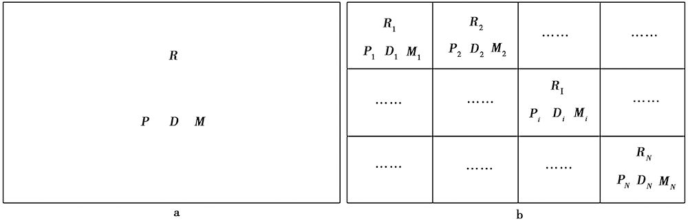
Fig. 1 A sketchmap showing the demographic information in the whole region and the sub-regions.
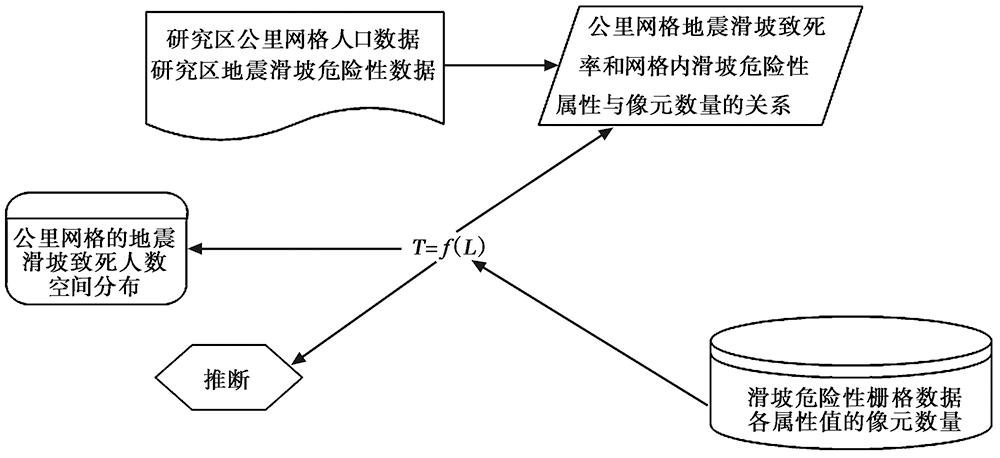
Fig. 2 Basic ideas of the evaluation of the death toll from earthquake-induced landslides.
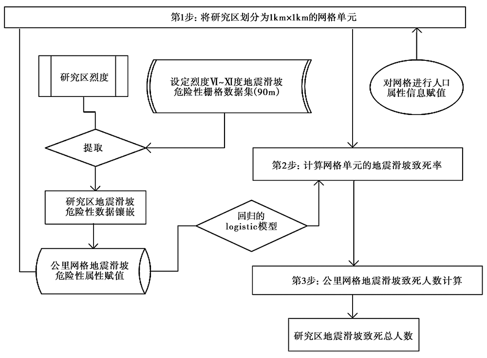
Fig. 3 Procedure of the rapid assessment of death toll from earthquake-induced landslides.
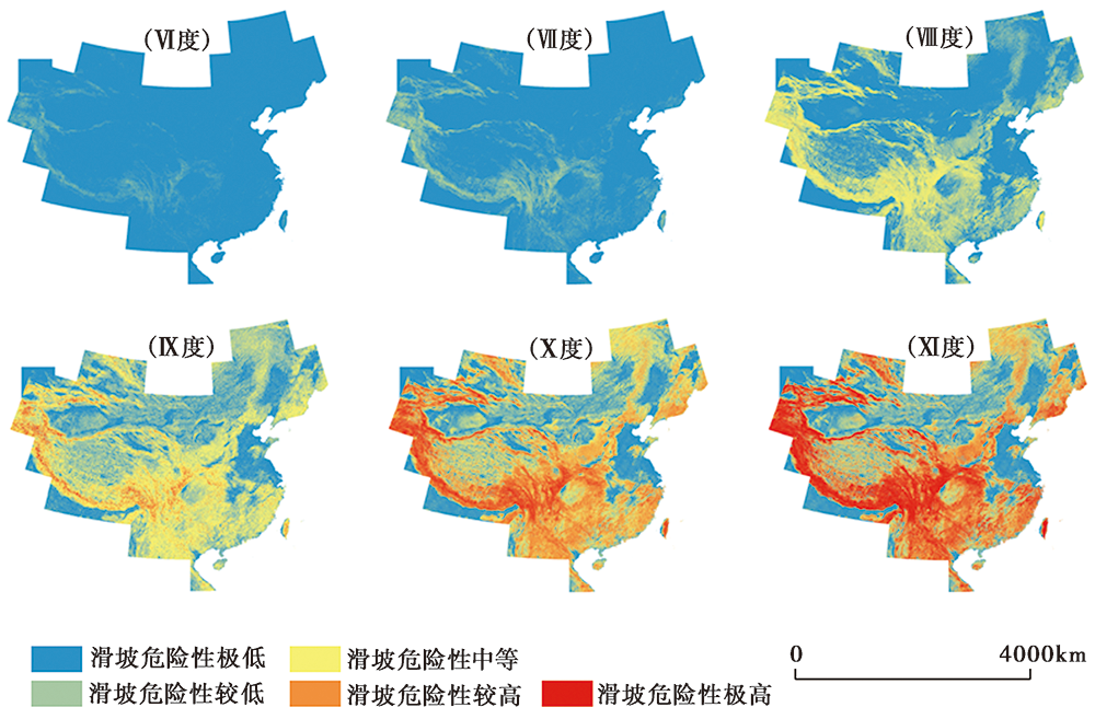
Fig. 4 Landslide susceptibility distribution assuming different seismic intensities, panels Ⅵ~Ⅺ show the landslide susceptibility according to intensity Ⅵ~Ⅺ(90m grid), respectively.
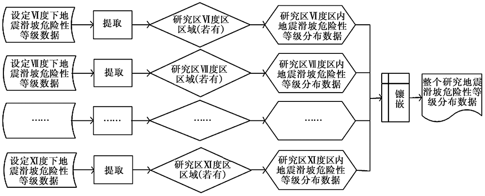
Fig. 5 A flow chart showing the susceptibility dataset of the earthquake-induced landslide.
| FID | P | X1 | X2 | X3 | X4 | X5 |
|---|---|---|---|---|---|---|
| 0 | P1 | X1,1 | X1,2 | X1,3 | X1,4 | X1,5 |
| 1 | P2 | X2,1 | X2,2 | X2,3 | X2,4 | X2,5 |
| …… | …… | …… | …… | …… | …… | …… |
| N-1 | PN | XN,1 | XN,2 | XN,3 | XN,4 | XN,5 |
Table2 A sample table of kilometer-grids’ properties
| FID | P | X1 | X2 | X3 | X4 | X5 |
|---|---|---|---|---|---|---|
| 0 | P1 | X1,1 | X1,2 | X1,3 | X1,4 | X1,5 |
| 1 | P2 | X2,1 | X2,2 | X2,3 | X2,4 | X2,5 |
| …… | …… | …… | …… | …… | …… | …… |
| N-1 | PN | XN,1 | XN,2 | XN,3 | XN,4 | XN,5 |
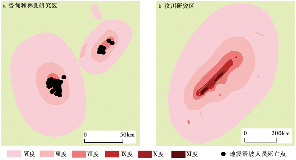
Fig. 6 The case study areas.
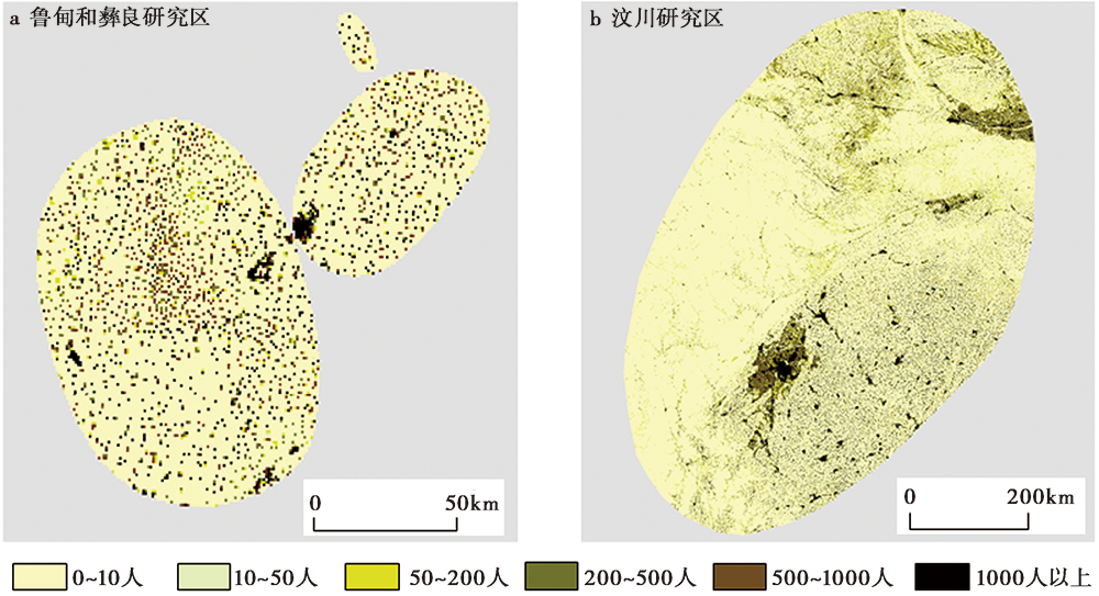
Fig. 7 The kilometer-grid population distribution in the study areas.
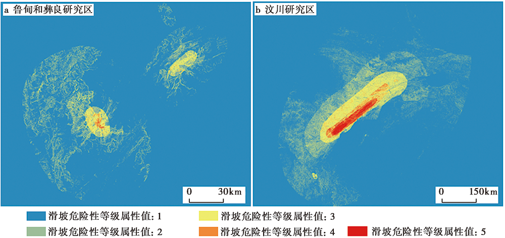
Fig. 8 Inversion of the distributions of the landslide susceptibility in the study areas(assessed results).
| P | D | M | X5 | X4 | X3 | X2 | X1 | P | D | M | X5 | X4 | X3 | X2 | X1 |
|---|---|---|---|---|---|---|---|---|---|---|---|---|---|---|---|
| 90 | 24 | 0.266 667 | 10 | 108 | 16 | 1 | 0 | 28 | 1 | 0.035 714 | 5 | 58 | 56 | 9 | 0 |
| 134 | 13 | 0.097 015 | 0 | 82 | 51 | 0 | 0 | 129 | 4 | 0.031 008 | 3 | 113 | 17 | 0 | 0 |
| 94 | 9 | 0.095 745 | 24 | 81 | 25 | 0 | 0 | 343 | 9 | 0.026 239 | 0 | 71 | 61 | 0 | 0 |
| 14 | 1 | 0.071 429 | 0 | 72 | 51 | 0 | 0 | 98 | 2 | 0.020 408 | 0 | 90 | 38 | 1 | 0 |
| 65 | 4 | 0.061 538 | 0 | 32 | 107 | 0 | 0 | 50 | 1 | 0.020 000 | 8 | 116 | 6 | 1 | 0 |
| 163 | 8 | 0.049 080 | 0 | 85 | 50 | 0 | 0 | 62 | 1 | 0.016 129 | 0 | 16 | 96 | 12 | 0 |
| 45 | 2 | 0.044 444 | 0 | 5 | 116 | 13 | 0 | 198 | 3 | 0.015 152 | 0 | 1 | 62 | 63 | 2 |
| 25 | 1 | 0.040 000 | 0 | 37 | 88 | 0 | 0 | 192 | 2 | 0.010 417 | 0 | 83 | 56 | 1 | 0 |
| 26 | 1 | 0.038 462 | 0 | 10 | 125 | 1 | 0 | 492 | 5 | 0.010 163 | 9 | 107 | 17 | 1 | 0 |
| 587 | 5 | 0.008 518 | 0 | 55 | 71 | 8 | 0 | 199 | 2 | 0.010 050 | 0 | 4 | 123 | 3 | 0 |
| 122 | 1 | 0.008 197 | 0 | 0 | 88 | 45 | 0 | 199 | 2 | 0.010 050 | 0 | 1 | 111 | 27 | 0 |
| 492 | 3 | 0.006 098 | 7 | 82 | 39 | 4 | 0 | 110 | 1 | 0.009 091 | 0 | 13 | 105 | 11 | 1 |
| 165 | 1 | 0.006 061 | 0 | 0 | 22 | 95 | 22 | 224 | 1 | 0.004 464 | 0 | 8 | 117 | 1 | 0 |
| 360 | 2 | 0.005 556 | 0 | 21 | 73 | 42 | 0 | 241 | 1 | 0.004 149 | 0 | 12 | 58 | 58 | 3 |
| 182 | 1 | 0.005 495 | 0 | 2 | 111 | 20 | 0 | 492 | 2 | 0.004 065 | 0 | 23 | 101 | 10 | 0 |
| 186 | 1 | 0.005 376 | 0 | 24 | 104 | 7 | 0 | 246 | 1 | 0.004 065 | 0 | 3 | 106 | 28 | 0 |
| 574 | 3 | 0.005 226 | 0 | 0 | 63 | 69 | 0 | 504 | 2 | 0.003 968 | 0 | 0 | 52 | 71 | 0 |
| 582 | 3 | 0.005 155 | 3 | 102 | 22 | 0 | 0 | 523 | 2 | 0.003 824 | 0 | 43 | 80 | 2 | 1 |
| 295 | 1 | 0.003 390 | 0 | 25 | 97 | 11 | 0 | 544 | 1 | 0.001 838 | 0 | 0 | 4 | 104 | 19 |
| 297 | 1 | 0.003 367 | 0 | 45 | 80 | 8 | 0 | 586 | 1 | 0.001 706 | 0 | 74 | 62 | 1 | 0 |
| 606 | 2 | 0.003 300 | 0 | 66 | 64 | 1 | 0 | 621 | 1 | 0.001 610 | 0 | 15 | 107 | 9 | 0 |
| 371 | 1 | 0.002 695 | 0 | 77 | 47 | 6 | 0 | 738 | 1 | 0.001 355 | 0 | 24 | 58 | 49 | 1 |
Table3 Property of the kilometer-grids in Ludian study area
| P | D | M | X5 | X4 | X3 | X2 | X1 | P | D | M | X5 | X4 | X3 | X2 | X1 |
|---|---|---|---|---|---|---|---|---|---|---|---|---|---|---|---|
| 90 | 24 | 0.266 667 | 10 | 108 | 16 | 1 | 0 | 28 | 1 | 0.035 714 | 5 | 58 | 56 | 9 | 0 |
| 134 | 13 | 0.097 015 | 0 | 82 | 51 | 0 | 0 | 129 | 4 | 0.031 008 | 3 | 113 | 17 | 0 | 0 |
| 94 | 9 | 0.095 745 | 24 | 81 | 25 | 0 | 0 | 343 | 9 | 0.026 239 | 0 | 71 | 61 | 0 | 0 |
| 14 | 1 | 0.071 429 | 0 | 72 | 51 | 0 | 0 | 98 | 2 | 0.020 408 | 0 | 90 | 38 | 1 | 0 |
| 65 | 4 | 0.061 538 | 0 | 32 | 107 | 0 | 0 | 50 | 1 | 0.020 000 | 8 | 116 | 6 | 1 | 0 |
| 163 | 8 | 0.049 080 | 0 | 85 | 50 | 0 | 0 | 62 | 1 | 0.016 129 | 0 | 16 | 96 | 12 | 0 |
| 45 | 2 | 0.044 444 | 0 | 5 | 116 | 13 | 0 | 198 | 3 | 0.015 152 | 0 | 1 | 62 | 63 | 2 |
| 25 | 1 | 0.040 000 | 0 | 37 | 88 | 0 | 0 | 192 | 2 | 0.010 417 | 0 | 83 | 56 | 1 | 0 |
| 26 | 1 | 0.038 462 | 0 | 10 | 125 | 1 | 0 | 492 | 5 | 0.010 163 | 9 | 107 | 17 | 1 | 0 |
| 587 | 5 | 0.008 518 | 0 | 55 | 71 | 8 | 0 | 199 | 2 | 0.010 050 | 0 | 4 | 123 | 3 | 0 |
| 122 | 1 | 0.008 197 | 0 | 0 | 88 | 45 | 0 | 199 | 2 | 0.010 050 | 0 | 1 | 111 | 27 | 0 |
| 492 | 3 | 0.006 098 | 7 | 82 | 39 | 4 | 0 | 110 | 1 | 0.009 091 | 0 | 13 | 105 | 11 | 1 |
| 165 | 1 | 0.006 061 | 0 | 0 | 22 | 95 | 22 | 224 | 1 | 0.004 464 | 0 | 8 | 117 | 1 | 0 |
| 360 | 2 | 0.005 556 | 0 | 21 | 73 | 42 | 0 | 241 | 1 | 0.004 149 | 0 | 12 | 58 | 58 | 3 |
| 182 | 1 | 0.005 495 | 0 | 2 | 111 | 20 | 0 | 492 | 2 | 0.004 065 | 0 | 23 | 101 | 10 | 0 |
| 186 | 1 | 0.005 376 | 0 | 24 | 104 | 7 | 0 | 246 | 1 | 0.004 065 | 0 | 3 | 106 | 28 | 0 |
| 574 | 3 | 0.005 226 | 0 | 0 | 63 | 69 | 0 | 504 | 2 | 0.003 968 | 0 | 0 | 52 | 71 | 0 |
| 582 | 3 | 0.005 155 | 3 | 102 | 22 | 0 | 0 | 523 | 2 | 0.003 824 | 0 | 43 | 80 | 2 | 1 |
| 295 | 1 | 0.003 390 | 0 | 25 | 97 | 11 | 0 | 544 | 1 | 0.001 838 | 0 | 0 | 4 | 104 | 19 |
| 297 | 1 | 0.003 367 | 0 | 45 | 80 | 8 | 0 | 586 | 1 | 0.001 706 | 0 | 74 | 62 | 1 | 0 |
| 606 | 2 | 0.003 300 | 0 | 66 | 64 | 1 | 0 | 621 | 1 | 0.001 610 | 0 | 15 | 107 | 9 | 0 |
| 371 | 1 | 0.002 695 | 0 | 77 | 47 | 6 | 0 | 738 | 1 | 0.001 355 | 0 | 24 | 58 | 49 | 1 |
| X | M | 合计 | ||
|---|---|---|---|---|
| 0 | >0 | |||
| X5 | 0 | 10 323 | 37 | 10 360 |
| >0 | 24 | 11 | 35 | |
| 合计 | 10 347 | 48 | 10 395 | |
| | 0 | 10 107 | 8 | 10 115 |
| >0 | 240 | 40 | 280 | |
| 合计 | 10 347 | 48 | 10 395 | |
| | 0 | 8 893 | 1 | 8 894 |
| >0 | 1 454 | 47 | 1 501 | |
| 合计 | 10 347 | 48 | 10 395 | |
| | 0 | 1 103 | 11 | 1 114 |
| >0 | 9 244 | 37 | 9 281 | |
| 合计 | 10 347 | 48 | 10 395 | |
| | 0 | 1 100 | 41 | 1 141 |
| >0 | 9 247 | 7 | 9 254 | |
| 合计 | 10 347 | 48 | 10 395 |
Table4 Contingency table about X and M
| X | M | 合计 | ||
|---|---|---|---|---|
| 0 | >0 | |||
| X5 | 0 | 10 323 | 37 | 10 360 |
| >0 | 24 | 11 | 35 | |
| 合计 | 10 347 | 48 | 10 395 | |
| | 0 | 10 107 | 8 | 10 115 |
| >0 | 240 | 40 | 280 | |
| 合计 | 10 347 | 48 | 10 395 | |
| | 0 | 8 893 | 1 | 8 894 |
| >0 | 1 454 | 47 | 1 501 | |
| 合计 | 10 347 | 48 | 10 395 | |
| | 0 | 1 103 | 11 | 1 114 |
| >0 | 9 244 | 37 | 9 281 | |
| 合计 | 10 347 | 48 | 10 395 | |
| | 0 | 1 100 | 41 | 1 141 |
| >0 | 9 247 | 7 | 9 254 | |
| 合计 | 10 347 | 48 | 10 395 |
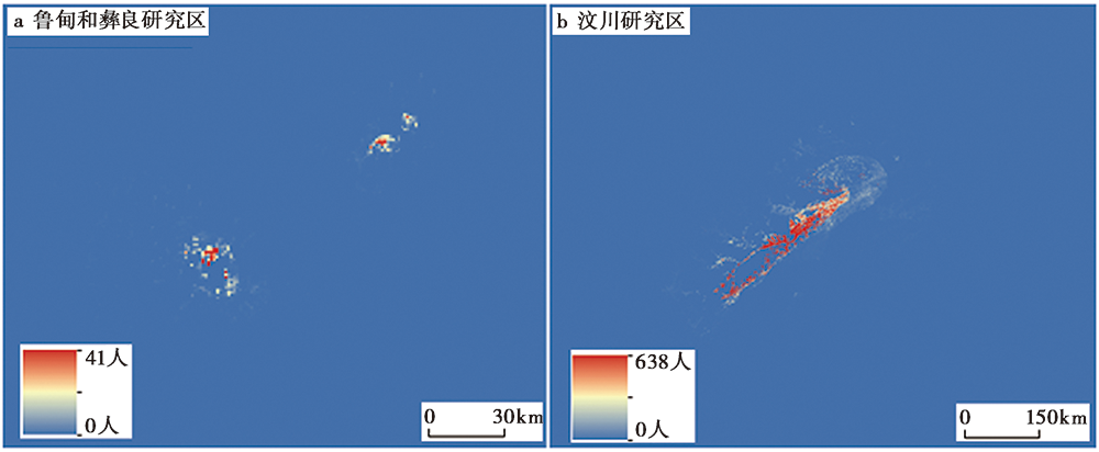
Fig. 9 Inversion of earthquake-induced landslides casualties using GIS and the logistic method.
| [1] |
安基文, 徐敬海, 聂高众, 等. 2015. 高精度承灾体数据支撑的地震灾情快速评估[J]. 地震地质, 37(4): 1225-1241. doi: 10.3969/j.issn.0253-4967.2015.04.022.
DOI |
| AN Ji-wen, XU Jing-hai, NIE Gao-zhong, et al. 2015. Earthquake disaster rapid assessment for emergency response supported by high-precision data of hazard bearing body[J]. Seismology and Geology, 37(4): 1225-1241. (in Chinese) | |
| [2] | 白仙富, 戴雨芡, 余庆坤, 等. 2014. 彝良“9·07”MS5.7、 5.6地震震亡人员研究[J]. 中国地震, 30(4): 571-582. |
| BAI Xian-fu, DAI Yu-qian, YU Qing-kun, et al. 2014. Casualty study of the Yiliang MS5.7 and MS5.6 earthquakes on September 7, 2014[J]. Earthquake Research in China, 30(4): 571-582. (in Chinese) | |
| [3] | 白仙富, 戴雨芡, 余庆坤, 等. 2015. 地震滑坡危险性评估模型及初步应用[J]. 地震研究, 38(2): 301-312. |
| BAI Xian-fu, DAI Yu-qian, YU Qing-kun, et al. 2015. Risk assessment modeling of earthquake-induced landslides and its preliminary application[J]. Journal of Seismological Research, 38(2): 301-312. (in Chinese) | |
| [4] | 曹彦波, 李永强. 2018. 云南地震应急关键技术与信息服务[M]. 昆明: 云南科技出版社: 81-82. |
| CAO Yan-bo, LI Yong-qiang. 2018. The Key Technology and Information Service for Earthquake Emergency of Yunnan Province[M]. Yunnan Science and Technology Press, Kunming: 81-82. (in Chinese) | |
| [5] | 陈晓利, 李杨, 洪启宇, 等. 2011. 地震作用下边坡动力响应的数值模拟研究[J]. 岩石学报, 27(6): 1899-1908. |
| CHEN Xiao-li, LI Yang, HONG Qi-yu, et al. 2011. Numerical simulation of earthquake effects on rock slope[J]. Acta Petrologica Sinica, 27(6): 1899-1908. (in Chinese) | |
| [6] | 陈振拓, 李志强, 丁文秀, 等. 2012. 面向防震减灾的人口数据空间化研究: 以2007 年宁洱地震灾区为例[J]. 震灾防御技术, 7(3): 273-284. |
| CHEN Zhen-tuo, LI Zhi-qiang, DING Wen-xiu, et al. 2012. Study of spatial population distribution in earthquake disaster reduction: A case study of 2007 Ning’er earthquake[J]. Technology for Earthquake Disaster Prevention, 7(3): 273-284. (in Chinese) | |
| [7] | 邓树荣, 张方浩, 余庆坤, 等. 2019. 一种地震应急响应级别判定方法[J]. 震灾防御技术, 14(2): 401-410. |
| DENG Shu-rong, ZHANG Fang-hao, YU Qing-kun, et al. 2019. A method of determining the level of earthquake emergency response[J]. Technology for Earthquake Disaster Prevention, 14(2): 401-410. (in Chinese) | |
| [8] | 丁文秀, 张亦梅, 陈振拓, 等. 2014. 湖北省人口数据空间化及在巴东MS5.1地震灾情盲估中的应用[J]. 大地测量与地球动力学, 34(3): 28-30. |
| DING Wen-xiu, ZHANG Yi-mei, CHEN Zhen-tuo, et al. 2014. Spatialization of population data for Hubei Province and its application to rapid assessment of earthquake loss: A case of Badong MS5.1 earthquake[J]. Journal of Geodesy and Geodynamics, 34(3): 28-30. (in Chinese) | |
| [9] | 高娜. 2015. 地震应急辐射能力研究[D]. 北京: 中国地震局地质研究所: 72-73. |
| GAO Na. 2015. A study on earthquake emergency radiation capacity[D]. Institute of Geology, China Earthquake Administration, Beijing: 72-73. (in Chinese) | |
| [10] | 高庆华, 刘惠敏, 李晓丽, 等. 2011. 中国地震次生地质灾害区域风险评估[M]. 北京: 气象出版社: 4-6. |
| GAO Qing-hua, LIU Hui-min, LI Xiao-li, et al. 2011. Regional Risk Assessment of Earthquake-induced Geological Disasters in China[M]. China Meteorological Press, Beijing: 4-6. (in Chinese) | |
| [11] | 刘甲美, 高孟潭, 吴树仁. 2016. 概率性地震滑坡危险性区划方法及其应用[J]. 岩石力学与工程学报, 35(S1): 3100-3110. |
| LIU Jia-mei, GAO Meng-tan, WU Shu-ren. 2016. Probabilistic seismic landslide hazard zonation method and its application[J]. Chinese Journal of Rock Mechanics and Engineering, 35(S1): 3100-3110. (in Chinese) | |
| [12] | 裴强, 夏超南, 刘小庆, 等. 2018. 预应力锚索抗滑桩支护边坡的地震动力响应分析[J]. 煤炭技术, 37(9): 57-58. |
| PEI Qiang, XIA Chao-nan, LIU Xiao-qing, et al. 2018. Analysis of seismic response of pre-stressed anchor pile reinforced slope under strong earthquake[J]. Coal Technology, 37(9): 57-58. (in Chinese) | |
| [13] | 邱丹丹, 牛瑞卿, 赵艳南. 2017. 不同采样策略下地震滑坡敏感性分析研究[J]. 岩石力学与工程学报, 36(S1): 3401-3408. |
| QIU Dan-dan, NIU Rui-qing, ZHAO Yan-nan. 2017. Susceptibility analysis of earthquake-induced landslides with different sampling strategies[J]. Journal of Rock Mechanics and Engineering, 36(S1): 3401-3408. (in Chinese) | |
| [14] | 魏连雨, 李慧, 董立颖, 等. 2016. 河北承德黄土动剪切模量与阻尼比试验研究[J]. 地震研究, 39(3): 513-518. |
| WEI Lian-yu, LI Hui, DONG Li-ying, et al. 2016. Study on experiment of dynamic shear modulus and damping ratio of loess in Chengde of Hebei[J]. Journal of Seismological Research, 39(3): 513-518. (in Chinese) | |
| [15] | 许冲, 徐锡伟, 周本刚, 等. 2019. 同震滑坡发生概率研究: 新一代地震滑坡危险性模型[J]. 工程地质学报, 27(5): 1122-1130. |
| XU Chong, XU Xi-wei, ZHOU Ben-gang, et al. 2019. Probability of coseismic landslides: A new generation of earthquake-triggered landslide hazard model[J]. Journal of Engineering Geology, 27(5): 1122-1130. (in Chinese) | |
| [16] | 杨根云, 周伟, 方教勇. 2019. 基于信息量模型和数据标准化的滑坡易发性评价[J]. 地球信息科学学报, 20(5): 674-683. |
| YANG Gen-yun, ZHOU Wei, FANG Jiao-yong. 2019. Assessment of landslide susceptibility based on information quantity model and data normalization[J]. Journal of Geo-information Science, 20(5): 674-683. (in Chinese) | |
| [17] | 易树健, 李渝生, 黄超, 等. 2018. 金沙江杀威台子滑坡成因动力学特性研究[J]. 防灾减灾工程学报, 38(2): 297-304. |
| YI Shu-jian, LI Yu-sheng, HUANG Chao, et al. 2018. The genetic dynamics characteristics of the Jinsha River Shaweitaizi landslide[J]. Journal of Disaster Prevention and Mitigation Engineering, 38(2): 297-304. (in Chinese) | |
| [18] | 张超. 2016. 金沙江杀威台子古地震滑坡成因动力学机理研究[D]. 成都: 成都理工大学: 3-4. |
| ZHANG Chao. 2016. The study of kinetic mechanism of Shawei paleoseismic landslide located by the Jinsha River[D]. Chengdu University of Technology, Chengdu: 3-4. (in Chinese) | |
| [19] | 张如前. 2015. 基于改进模糊聚类迭代和神经网络的边坡失稳预测方法[D]. 南昌: 江西理工大学:11. |
| ZHANG Ru-qian. 2015. A landslides forecast method based on improved fuzzy clustering iterative model and BP neural composite model[D]. Jiangxi University of Science and Technology, Nanchang: 11 (in Chinese) | |
| [20] |
An J W, Bai X F, Xu J H, et al. 2015. Prediction of highway blockage caused by earthquake-induced landslides for improving earthquake emergency response[J]. Natural Hazards, 79(1): 511-536.
DOI URL |
| [21] | Chen Y, David C B. 2011. The Wenchuan earthquake of 2008: Anatomy of a Disaster [M]. Science Press, Beijing: 6-7. |
| [22] |
Keeper D K. 1984. Landslides caused by earthquakes[J]. Geological Society of America Bulletin, 95(4): 406-421.
DOI URL |
| [23] |
Kobayashi Y. 1994. Effect of basal guided waves on landslides[J]. Pure and Applied Geophysics, 142(2): 329-346.
DOI URL |
| [24] |
Pain C F. 1972. Characteristics and geomorphic effects of earthquake-initiated landslides in the Adelbert Range, Papua New Guinea[J]. Engineering Geology, 6(4): 261-274.
DOI URL |
| [25] |
Plafker G, Ericksen G E, Concha J F. 1971. Geological aspects of the May 31, 1970, Perú earthquake[J]. Bulletin of the Seismological Society of America, 61(3): 543-578.
DOI URL |
| [26] |
Yuan R M, Deng Q H, Cunningham D, et al. 2013. Density distribution of landslides triggered by the 2008 Wenchuan earthquake and their relationships to peak ground acceleration[J]. Bulletin of the Seismological Society of America, 103(4): 2344-2355.
DOI URL |
| [1] | NIE Gao-zhong, XU Jing-hai. SEISMIC INTENSITY EVALUATION MODEL IN MEIZOSEISMAL AREA BASED ON FOCAL DEPTH [J]. SEISMOLOGY AND GEOLOGY, 2018, 40(3): 611-621. |
| Viewed | ||||||
|
Full text |
|
|||||
|
Abstract |
|
|||||
