SEISMOLOGY AND EGOLOGY ›› 2021, Vol. 43 ›› Issue (6): 1507-1523.DOI: 10.3969/j.issn.0253-4967.2021.06.009
• Research paper • Previous Articles Next Articles
LIANG Zi-han( ), WEI Zhan-yu(), ZHUANG Qi-tian, SUN Wen, HE Hong-lin
Received:2020-09-30
Revised:2021-01-15
Online:2021-12-20
Published:2022-01-29
Contact:
WEI Zhan-yu
梁子晗(), 魏占玉(), 庄其天, 孙稳, 何宏林
通讯作者:
魏占玉
作者简介:梁子晗, 女, 1996年生, 2018年于云南大学获地质学专业学士学位, 现为中国地震局地质研究所构造地质学专业在读硕士研究生, 主要从事活动构造与构造地貌研究, E-mail: lzhapple@hotmail.com。
基金资助:CLC Number:
LIANG Zi-han, WEI Zhan-yu, ZHUANG Qi-tian, SUN Wen, HE Hong-lin. SEGMENTATION OF SURFACE RUPTURE AND OFFSETS CHARACTERISTICS OF THE FUYUN M8.0 EARTHQUAKE BASED ON HIGH-RESOLUTION TOPOGRAPHIC DATA[J]. SEISMOLOGY AND EGOLOGY, 2021, 43(6): 1507-1523.
梁子晗, 魏占玉, 庄其天, 孙稳, 何宏林. 基于高分辨率地形数据的富蕴M8.0地震地表破裂带精细特征[J]. 地震地质, 2021, 43(6): 1507-1523.
Add to citation manager EndNote|Ris|BibTeX
URL: https://www.dzdz.ac.cn/EN/10.3969/j.issn.0253-4967.2021.06.009
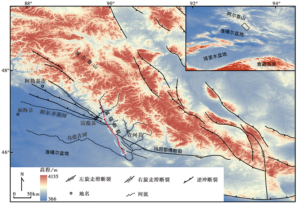
Fig. 1 Tectonic and geomorphic map of the southwest margin of the Altai Mountains.
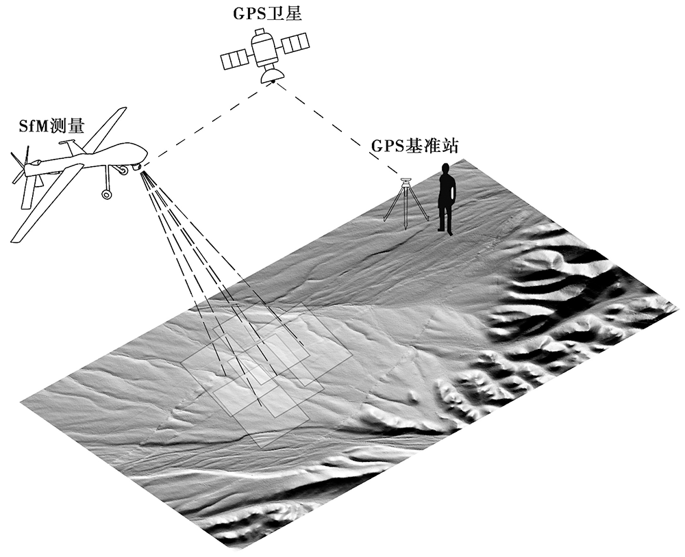
Fig. 2 Schematic illustration of UAV platform-based structure from motion.
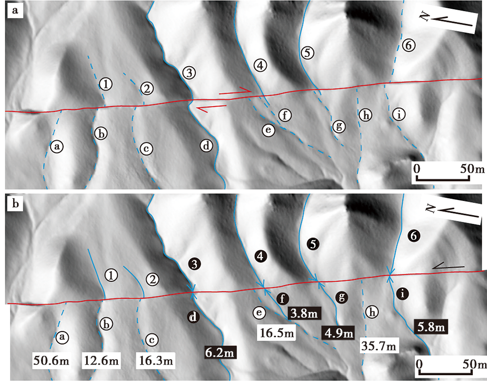
Fig. 3 Determination of the coseismic horizontal displacement of the 1931 Fuyun earthquake.

Fig. 4 Principle of horizontal displacement measurement.
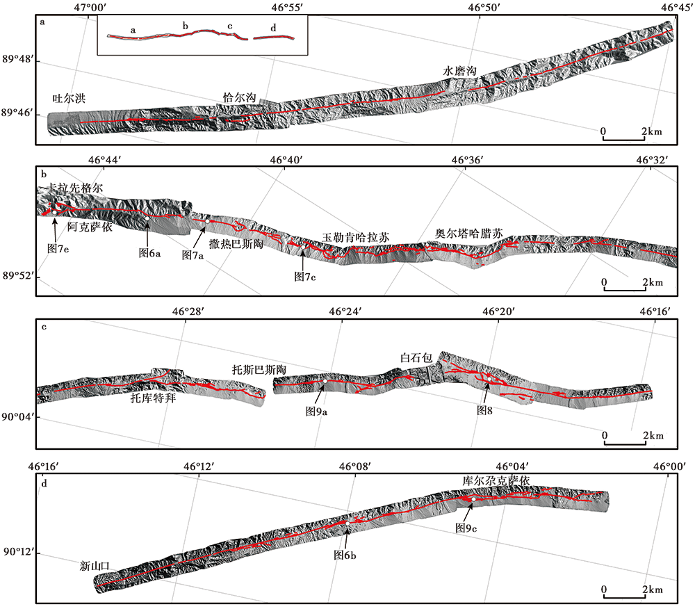
Fig. 5 The DEM data of the study area and results of surface rupture interpretation.
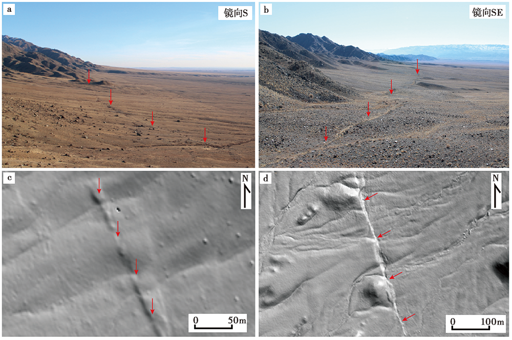
Fig. 6 Linear characteristics of the surface rupture zone of Fuyun earthquake.
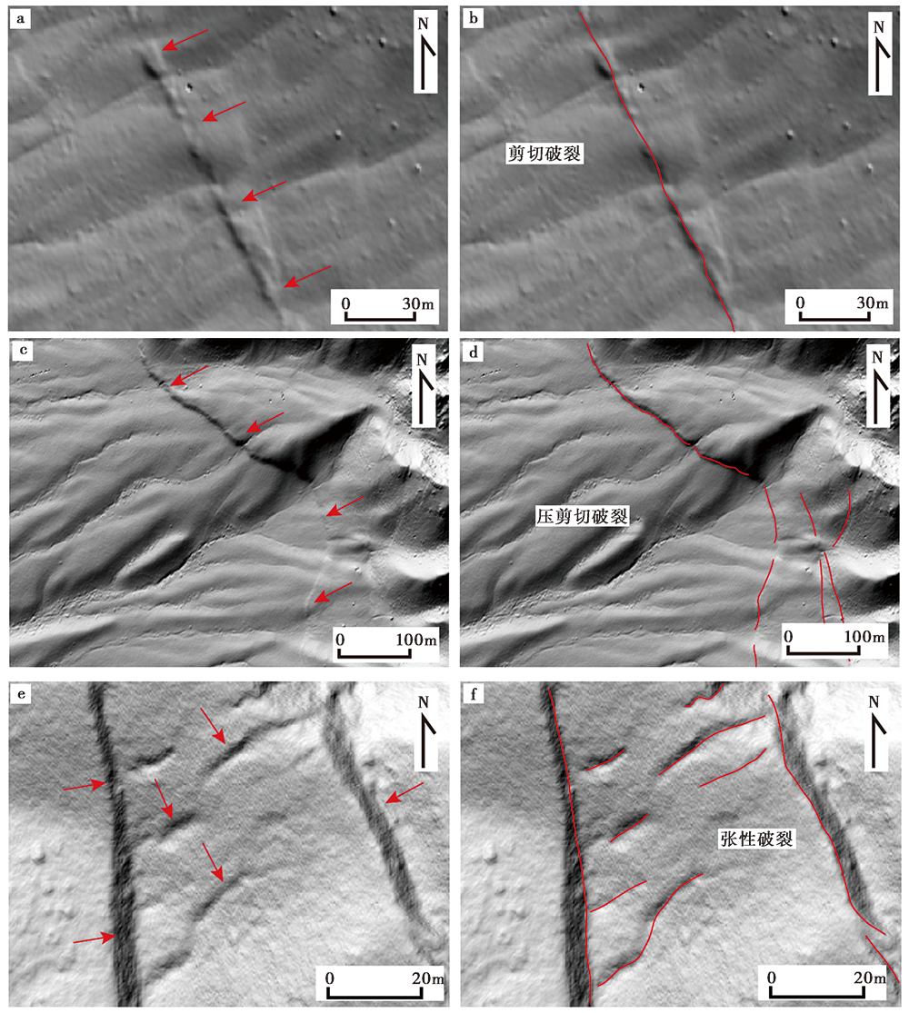
Fig. 7 Typical surface ruptures in the surface rupture zone of Fuyun earthquake.
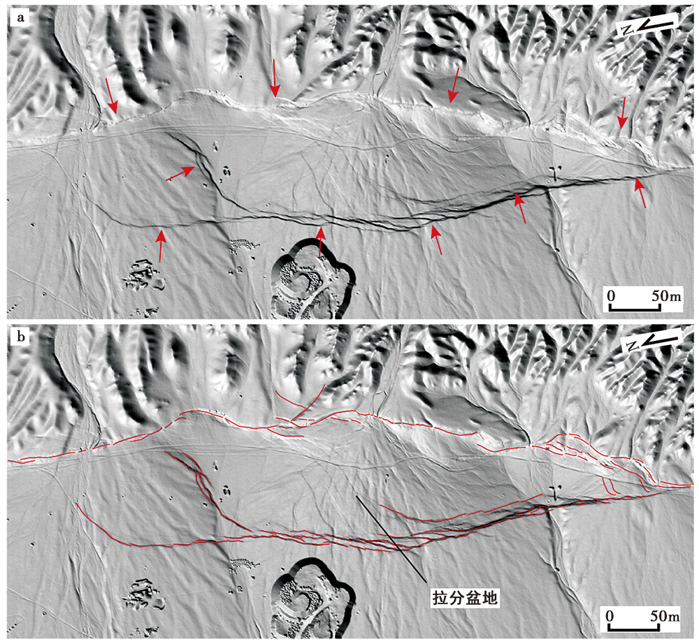
Fig. 8 Typical pull-apart basin in the surface rupture zone of Fuyun earthquake.
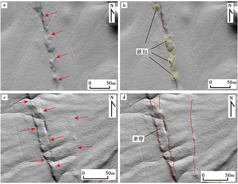
Fig. 9 Typical mole tracks and ridges in Fuyun earthquake surface rupture zone.
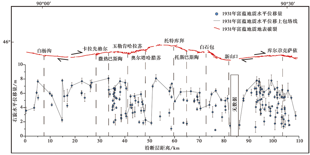
Fig. 10 Distribution of dextral horizontal displacement of the 1931 Fuyun earthquake.
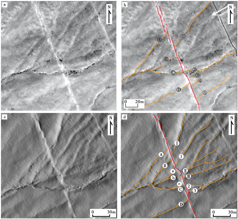
Fig. 11 Data accuracy comparison of the SfM-derived DEM with quickbird satellite image.
| 发生地震的断裂 | 震级 | 平均同震位移量/m |
|---|---|---|
| 圣安德烈斯断裂(Zielke et al., | MW7.9 | 5.3±1.4 |
| 海原断裂(Ren et al., | MS8.5 | 约5 |
| 沂沭断裂带(Jiang et al., | M8.5 | 约9 |
| 戈壁-阿尔泰断裂(Kurtz et al., | MW8.1 | 3.5±1.3 |
Table1 Statistics of some earthquakes and their average coseismic displacements
| 发生地震的断裂 | 震级 | 平均同震位移量/m |
|---|---|---|
| 圣安德烈斯断裂(Zielke et al., | MW7.9 | 5.3±1.4 |
| 海原断裂(Ren et al., | MS8.5 | 约5 |
| 沂沭断裂带(Jiang et al., | M8.5 | 约9 |
| 戈壁-阿尔泰断裂(Kurtz et al., | MW8.1 | 3.5±1.3 |
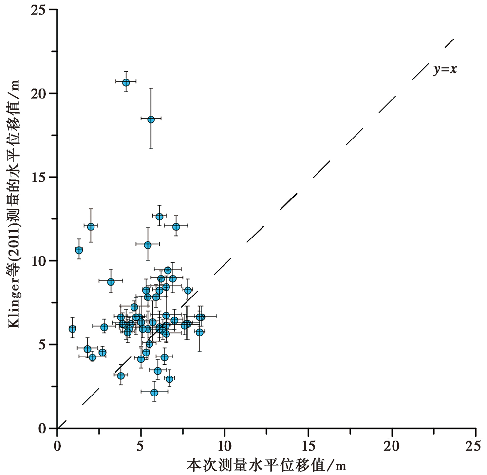
Fig. 12 Comparison of the displacement measurements in this study with those acquired by Klinger et al.(2011).
| [1] | 艾明, 毕海芸, 郑文俊, 等. 2018. 利用无人机摄影测量技术提取活动构造定量参数[J]. 地震地质, 40(6): 1276-1293. |
| AI Ming, BI Hai-yun, ZHENG Wen-jun, et al. 2018. Using unmanned aerial vehicle photogrammetry technology to obtain quantitative parameters of active tectonics[J]. Seismology and Geology, 40(6): 1276-1293(in Chinese). | |
| [2] | 安艳芬, 韩竹军, 董绍鹏, 等. 2010. 汶川 MS8.0 地震中央断裂东北端地表破裂特征及其构造含义[J]. 地震地质, 32(1): 1-15. |
| AN Yan-fen, HAN Zhu-jun, DONG Shao-peng, et al. 2010. Features and tectonic implications of the northeasternmost surface rupture of Wenchuan MS8.0 earthquake on the Central Fault of Longmenshan fault zone[J]. Seismology and Geology, 32(1): 1-15(in Chinese). | |
| [3] | 柏美祥. 2001. 富蕴地震断裂带北部细部结构特征[J]. 内陆地震, 15(2): 97-103. |
| BO Mei-xiang. 2001. Detailed structural features in the north of Fuyun earthquake fault zone[J]. Inland Earthquake, 15(2): 97-103(in Chinese). | |
| [4] | 柏美祥, 罗福忠, 尹光华, 等. 1996. 新疆可可托海-二台活动断裂带[J]. 内陆地震, 10(4): 319-329. |
| BO Mei-xiang, LUO Fu-zhong, YIN Guang-hua, et al. 1996. Kokotokay-Ertai active fault zone in Xinjiang[J]. Inland Earthquake, 10(4): 319-329(in Chinese). | |
| [5] | 陈立春, 王虎, 冉勇康, 等. 2010. 玉树 MS7.1 地震地表破裂与历史大地震[J]. 科学通报, 55(13): 1200-1205. |
| CHEN Li-chun, WANG Hu, RAN Yong-kang, et al. 2010. The MS7.1 Yushu earthquake surface ruptures and historical earthquakes[J]. Chinese Science Bulletin, 55(13): 1200-1205(in Chinese). | |
| [6] |
刘金瑞, 任治坤, 张会平, 等. 2018. 海原断裂带老虎山段晚第四纪滑动速率精确厘定与讨论[J]. 地球物理学报, 61(4): 1281-1297. doi: 10.6038/cj92018L0364.
DOI |
| LIU Jin-rui, REN Zhi-kun, ZHANG Hui-ping, et al. 2018. Late Quaternary slip rate of the Laohushan Fault within the Haiyuan fault zone and its tectonic implications[J]. Chinese Journal of Geophysics, 61(4): 1281-1297(in Chinese). | |
| [7] | 单新建, 李建华, 马超. 2005. 昆仑山口西 MS8.1 地震地表破裂带高分辨率卫星影像特征研究[J]. 地球物理学报, 48(2): 321-326. |
| SHAN Xin-jian, LI Jian-hua, MA Chao. 2005. Study on the feature of surface rupture zone of the west of Kunlunshan Pass earthquake( MS8.1 )with high spatial resolution satellite images[J]. Chinese Journal of Geophysics, 48(2): 321-326(In Chinese). | |
| [8] | 魏占玉, Arrowsmith R, 何宏林, 等. 2015. 基于SfM方法的高密度点云数据生成及精度分析[J]. 地震地质, 37(2): 636-648. |
| WEI Zhan-yu, Arrowsmith R, HE Hong-lin, et al. 2015. Accuracy analysis of terrain point cloud acquired by “structure from motion” using aerial photos[J]. Seismology and Geology, 37(2): 636-648(in Chinese). | |
| [9] | 新疆维吾尔自治区地震局. 1985. 富蕴地震断裂带[M]. 北京: 地震出版社: 1-206. |
| Seismological Bureau of Xinjiang Uygur Autonomous Region. 1985. The Fuyun Earthquake Fault Zone in Xinjiang, China[M]. Seismological Press, Beijing: 1-206(in Chinese). | |
| [10] | 徐锡伟, 孙鑫喆, 谭锡斌, 等. 2012. 富蕴断裂: 低应变速率条件下断层滑动习性[J]. 地震地质, 34(4): 606-617. |
| XU Xi-wei, SUN Xin-zhe, TAN Xi-bin, et al. 2012. Fuyun Fault: Long-term faulting behavior under low crustal strain rate[J]. Seismology and Geology, 34(4): 606-617(in Chinese). | |
| [11] | 徐锡伟, 闻学泽, 叶建青, 等. 2008. 汶川 MS8.0 地震地表破裂带及其发震构造[J]. 地震地质, 30(3): 597-629. |
| XU Xi-wei, WEN Xue-ze, YE Jian-qing, et al. 2008. The MS8.0 Wenchuan earthquake surface ruptures and its seismogenic structure[J]. Seismology and Geology, 30(3): 597-629(in Chinese). | |
| [12] | 徐岳仁, 陈立泽, 申旭辉, 等. 2015. 基于GF-1卫星影像解译2014年新疆于田 MS7.3 地震同震地表破裂带[J]. 地震, 35(2): 61-71. |
| XU Yue-ren, CHEN Li-ze, SHEN Xu-hui, et al. 2015. Interpreting coseismic surface rupture zone of the 2014 Yutian MS7.3 earthquake using GF-1 satellite images[J]. Earthquake, 35(2): 61-71(in Chinese). | |
| [13] | 张之武. 2009. 新疆阿尔泰山富蕴断裂带几何学与地貌学特征研究[D]. 北京: 中国科学院青藏高原研究所:1-64. |
| ZHANG Zhi-wu. 2009. Geometric and geomorphologic features of the Fuyun fault zone in the Altay Mountains, Xinjiang, China [D]. Institute of Tibetan Plateau Research, Chinese Academy of Sciences, Beijing: 1-64(in Chinese). | |
| [14] | Calais E, Vergnolle M, San'kov V, et al. 2003. GPS measurements of crustal deformation in the Baikal-Mongolia area(1994-2002): Implications for current kinematics of Asia[J]. Journal of Geophysical Research: Solid Earth, 108(B10): 2501-2514. |
| [15] |
Chen T, Liu-Zeng J, Shao Y X, et al. 2018. Geomorphic offsets along the creeping Laohu Shan section of the Haiyuan Fault, northern Tibetan plateau[J]. Geosphere, 14(3): 1165-1186.
DOI URL |
| [16] | Choi J-H, Jin K, Enkhbayar D, et al. 2012. Rupture propagation inferred from damage patterns, slip distribution, and segmentation of the 1957 MW8.1 Gobi-Altay earthquake rupture along the Bogd Fault, Mongolia[J]. Journal of Geophysical Research Solid Earth, 117(B12): 401-425. |
| [17] |
Guo P, Han Z J, Dong S P, et al. 2019. Surface rupture and slip distribution along the Lenglongling Fault in the NE Tibetan plateau: Implications for faulting behavior[J]. Journal of Asian Earth Sciences, 172:190-207.
DOI URL |
| [18] |
Harwin S, Lucieer A. 2012. Assessing the accuracy of georeferenced point clouds produced via multi-view stereopsis from unmanned aerial vehicle(UAV)imagery[J]. Remote Sensing, 4(6): 1573-1599.
DOI URL |
| [19] |
Jiang W L, Zhang J F, Han Z J, et al. 2017. Characteristic slip of strong earthquakes along the Yishu fault zone in East China evidenced by offset landforms[J]. Tectonics, 36(10): 1947-1965.
DOI URL |
| [20] |
Johnson K, Nissen E, Saripalli S, et al. 2014. Rapid mapping of ultrafine fault zone topography with structure from motion[J]. Geosphere, 10(5): 969-986.
DOI URL |
| [21] |
Kang W J, Xu X W, Oskin M E, et al. 2020. Characteristic slip distribution and earthquake recurrence along the eastern Altyn Tagh Fault revealed by high-resolution topographic data[J]. Geosphere, 16(1): 392-406.
DOI URL |
| [22] |
Klinger Y, Etchebes M, Tapponnier P, et al. 2011. Characteristic slip for five great earthquakes along the Fuyun Fault in China[J]. Nature Geoscience, 4(6): 389-392.
DOI URL |
| [23] |
Kurtz R, Klinger Y, Ferry M, et al. 2018. Horizontal surface-slip distribution through several seismic cycles: The eastern Bogd Fault, Gobi-Altai, Mongolia[J]. Tectonophysics, 734-735:167-182.
DOI URL |
| [24] | Ren Z K, Zhang Z Q, Chen T, et al. 2015. Clustering of offsets on the Haiyuan Fault and their relationship to paleoearthquakes[J]. Geological Society of America Bulletin, 128(1-2): 3-18. |
| [25] | Tapponnier P, Molnar P. 1979. Active faulting and Cenozoic tectonics of the Tien Shan, Mogolia and Baykal regions[J]. Journal of Geophysical Research: Solid Earth, 84(B7): 3425-3459. |
| [26] | Wells D L, Coppersmith K J. 1994. New empirical relationships among magnitude, rupture length, rupture width, rupture area, and surface displacement[J]. Bulletin of the Seismological Society of America, 84(4): 974-1002. |
| [27] |
Westoby M J, Brasington J, Glasser N F, et al. 2012. ‘Structure-from-Motion’ photogrammetry: A low-cost, effective tool for geoscience applications[J]. Geomorphology, 179:300-314.
DOI URL |
| [28] |
Zielke O, Arrowsmith J R. 2012. LaDiCaoz and LiDAR imager: MATLAB GUIs for LiDAR data handling and lateral displacement measurement[J]. Geosphere, 8(1): 206-221.
DOI URL |
| [29] |
Zielke O, Arrowsmith J R, Grant Ludwig L, et al. 2010. Slip in the 1857 and earlier large earthquakes along the Carrizo Plain, San Andreas Fault[J]. Science, 327(5969): 1119-1122.
DOI PMID |
| [30] |
Zielke O, Klinger Y, Arrowsmith J R. 2015. Fault slip and earthquake recurrence along strike-slip faults: Contributions of high-resolution geomorphic data[J]. Tectonophysics, 638:43-62.
DOI URL |
| [1] | WU Xi-yan, XU Xi-wei, YU Gui-hua, CHENG Jia, CHEN Gui-hua, AN Yan-fen, WANG Qi-xin. MAP PREPARATION OF EARTHQUAKE SURFACE RUPTURES IN THE NATIONAL EXPERIMENTAL FIELD OF EARTHQUAKE MONITORING AND PREDICTION IN SICHUAN AND YUNNAN PROVINCE [J]. SEISMOLOGY AND GEOLOGY, 2018, 40(1): 27-41. |
| [2] | XU Xi-wei, GUO Ting-ting, LIU Shao-zhuo, YU Gui-hua, CHEN Gui-hua, WU Xi-yan. DISCUSSION ON ISSUES ASSOCIATED WITH SETBACK DISTANCE FROM ACTIVE FAULT [J]. SEISMOLOGY AND GEOLOGY, 2016, 38(3): 477-502. |
| [3] | XU Xi-wei, TAN Xi-bin, WU Guo-dong, CHEN Jian-bo, SHEN Jun, FANG Wei, SONG He-ping. SURFACE RUPTURE FEATURES OF THE 2008 YUTIAN MS 7.3 EARTHQUAKE AND ITS TECTONIC NATURE [J]. SEISMOLOGY AND GEOLOGY, 2011, 33(2): 462-471. |
| [4] | ZHAO Bo-ming, XU Xi-wei. AN ANALYSIS ON MS 8.0 WENCHUAN EARTHQUAKE FAULT AND SEISMIC DISASTER [J]. SEISMOLOGY AND GEOLOGY, 2008, 30(4): 839-854. |
| [5] | XU Xi-wei, WEN Xue-ze, YE Jian-qing, MA Bao-qi, CHEN Jie, ZHOU Rong-jun, HE Hong-lin, TIAN Qin-jian, HE Yu-lin, WANG Zhi-cai, SUN Zhao-min, FENG Xi-jie, YU Gui-hua, CHEN Li-chun, CHEN Gui-hua, YU Shen-e, RAN Yong-kang, LI Xi-guang, LI Chen-xia, AN Yan-fen. THE MS8.0 WENCHUAN EARTHQUAKE SURFACE RUPTURES AND ITS SEISMOGENIC STRUCTURE [J]. SEISMOLOGY AND GEOLOGY, 2008, 30(3): 597-629. |
| [6] | LI Chen-xia, DAI Hua-guang, CHEN Yong-ming, XU Xi-wei, DAI Wei. THE DISCUSSION ON SOME PROBLEMS OF THE Ms7.5 TUOSUOHU LAKE EARTHQUAKE IN 1937 [J]. SEISMOLOGY AND GEOLOGY, 2006, 28(1): 12-21. |
| [7] | XU Xi-wei, YU Gui-hua, MA Wen-tao, RAN Yong-kang, CHEN Gui-hua, HAN Zhu-jun, Zhang, Lan-feng, YOU Hui-chuan. EVIDENCE AND METHODS FOR DETERMINING THE SAFETY DISTANCE FROM THE POTENTIAL EARTHQUAKE SURFACE RUPTURE ON ACTIVE FAULT [J]. SEISMOLOGY AND GEOLOGY, 2002, 24(4): 470-483. |
| Viewed | ||||||
|
Full text |
|
|||||
|
Abstract |
|
|||||
