SEISMOLOGY AND EGOLOGY ›› 2021, Vol. 43 ›› Issue (6): 1537-1562.DOI: 10.3969/j.issn.0253-4967.2021.06.011
• Research paper • Previous Articles Next Articles
WANG Jian1,2)( ), SHEN Chong-yang1),*(), SUN Wen-ke2), TAN Hong-bo1), HU Min-zhang1), LIANG Wei-feng3), HAN Yu-fei4), ZHANG Xin-lin1), WU Gui-ju1), WANG Qing-hua5)
Received:2021-02-19
Revised:2021-04-23
Online:2021-12-20
Published:2022-01-29
Contact:
SHEN Chong-yang
汪健1,2)(), 申重阳1),*(), 孙文科2), 谈洪波1), 胡敏章1), 梁伟锋3), 韩宇飞4), 张新林1), 吴桂桔1), 王青华5)
通讯作者:
申重阳
作者简介:汪健, 男, 1986年生, 2011年于中国地震局地震研究所获固体地球物理专业硕士学位, 现为中国科学院大学固体地球物理专业在读博士研究生, 助理研究员, 主要从事重力场变化监测研究, E-mail: wangjian196@mails.ucas.ac.cn。
基金资助:CLC Number:
WANG Jian, SHEN Chong-yang, SUN Wen-ke, TAN Hong-bo, HU Min-zhang, LIANG Wei-feng, HAN Yu-fei, ZHANG Xin-lin, WU Gui-ju, WANG Qing-hua. STUDY ON PRESENT GRAVITY CHANGE AND DEEP CRUST DEFORMATION IN THE NORTHERN AND MIDDLE SECTIONS OF THE RED RIVER FAULT ZONE[J]. SEISMOLOGY AND EGOLOGY, 2021, 43(6): 1537-1562.
汪健, 申重阳, 孙文科, 谈洪波, 胡敏章, 梁伟锋, 韩宇飞, 张新林, 吴桂桔, 王青华. 红河断裂带北、 中段近期重力变化及深部变形[J]. 地震地质, 2021, 43(6): 1537-1562.
Add to citation manager EndNote|Ris|BibTeX
URL: https://www.dzdz.ac.cn/EN/10.3969/j.issn.0253-4967.2021.06.011
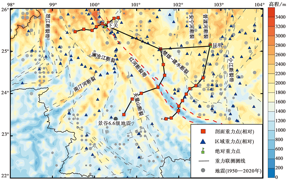
Fig. 1 Map of seismic activity and gravity stations of the Red River fault zone.
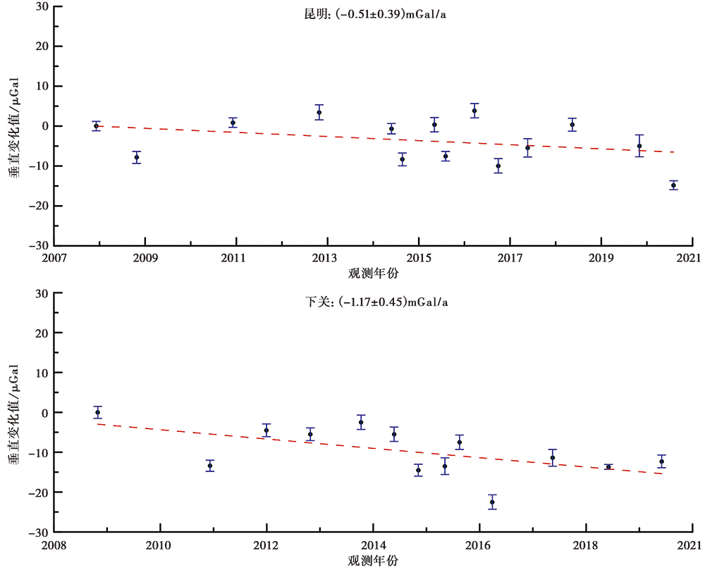
Fig. 2 Absolute gravity results observed at Kunming and Xiaguan stations.
| 观测时间 | 观测仪器类型及编号 | 顺序+交替观测平均点值精度/μGal | 常规顺序观测平均点值精度/μGal |
|---|---|---|---|
| 2013-11 | CG-5(509、 834、 845) | 6.0 | 6.9 |
| 2014-05 | CG-5(509、 834、 845) | 7.3 | 8.4 |
| 2014-11 | CG-5(509、 834、 845) | 9.1 | 10.5 |
| 2015-04 | CG-5(217、 509) | 9.5 | 10.7 |
| 2015-11 | CG-5(230、 834、 845) | 10.2 | 11.7 |
| 2016-04 | CG-5(221、 231) | 12.5 | 14.1 |
| 2016-08 | CG-5(221、 231) | 12.1 | 13.7 |
| 2016-11 | CG-5(834、 845) | 9.4 | 12.2 |
| 2017-05 | CG-5(834、 845) | 9.5 | 10.1 |
| 2019-08 | CG-5(834、 845、 1169、 1170) | 11.2 | 11.7 |
Table1 The time and accuracy of mobile gravity measurement
| 观测时间 | 观测仪器类型及编号 | 顺序+交替观测平均点值精度/μGal | 常规顺序观测平均点值精度/μGal |
|---|---|---|---|
| 2013-11 | CG-5(509、 834、 845) | 6.0 | 6.9 |
| 2014-05 | CG-5(509、 834、 845) | 7.3 | 8.4 |
| 2014-11 | CG-5(509、 834、 845) | 9.1 | 10.5 |
| 2015-04 | CG-5(217、 509) | 9.5 | 10.7 |
| 2015-11 | CG-5(230、 834、 845) | 10.2 | 11.7 |
| 2016-04 | CG-5(221、 231) | 12.5 | 14.1 |
| 2016-08 | CG-5(221、 231) | 12.1 | 13.7 |
| 2016-11 | CG-5(834、 845) | 9.4 | 12.2 |
| 2017-05 | CG-5(834、 845) | 9.5 | 10.1 |
| 2019-08 | CG-5(834、 845、 1169、 1170) | 11.2 | 11.7 |
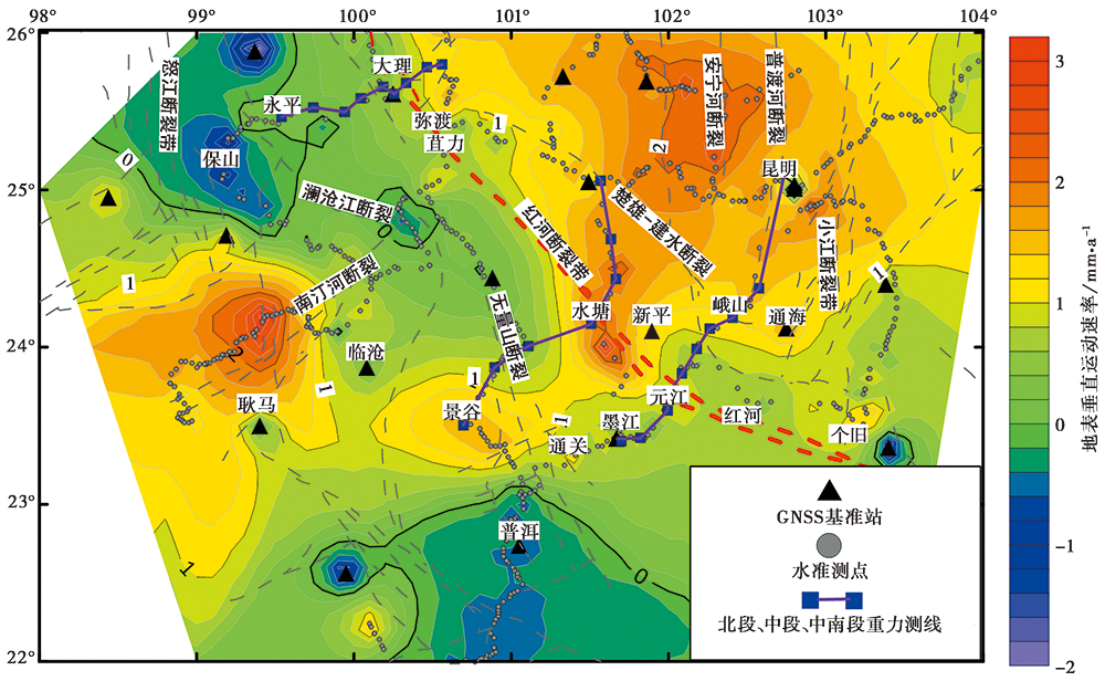
Fig. 3 Vertical deformation rate of the Red River fault zone(after Hao et al., 2014, 2016; Pan et al., 2018).
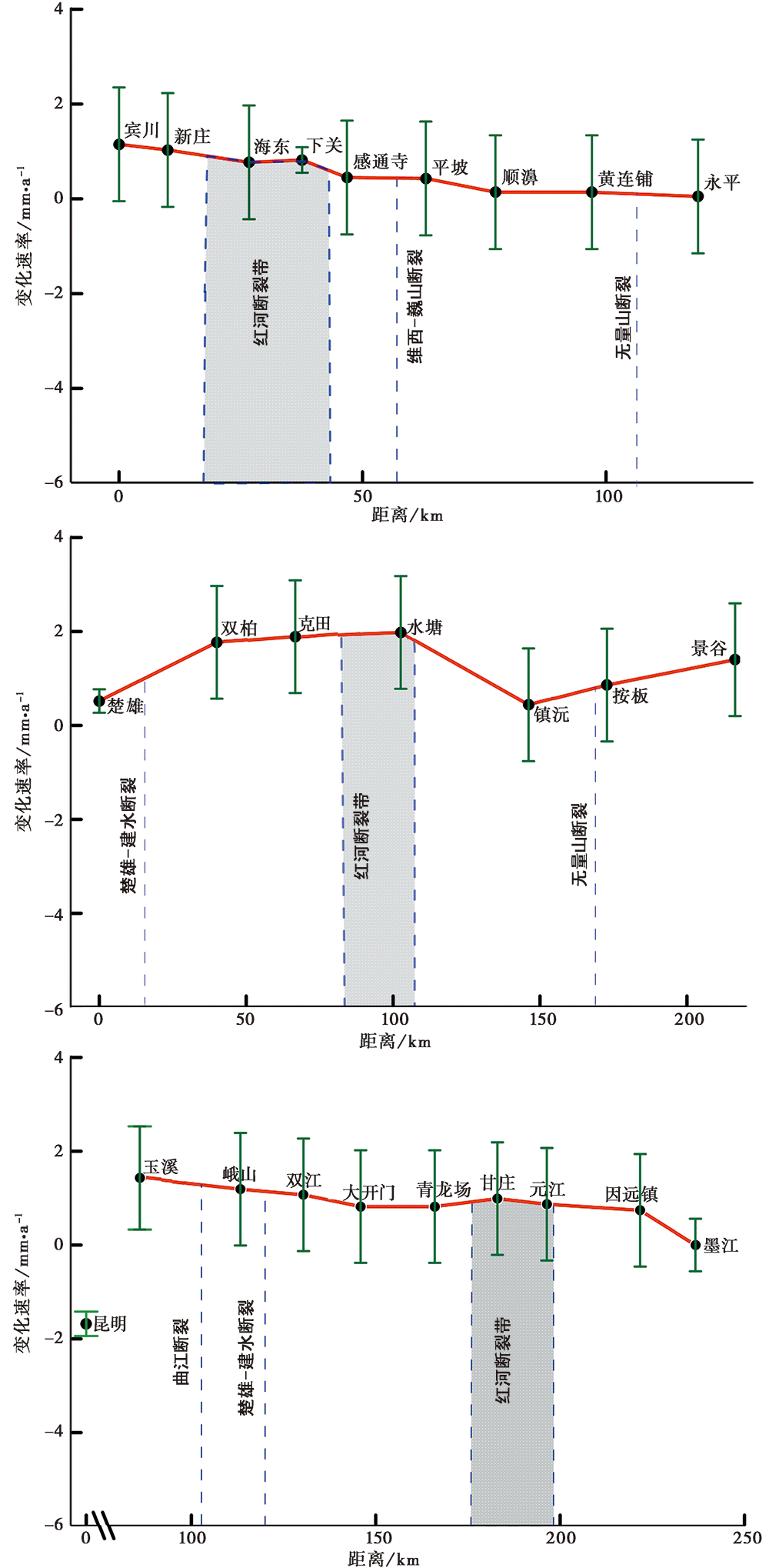
Fig. 4 Vertical deformation rate of the Binchuan-Yongping, Chuxiong-Jinggu, and Kunming-Mojiang profiles.
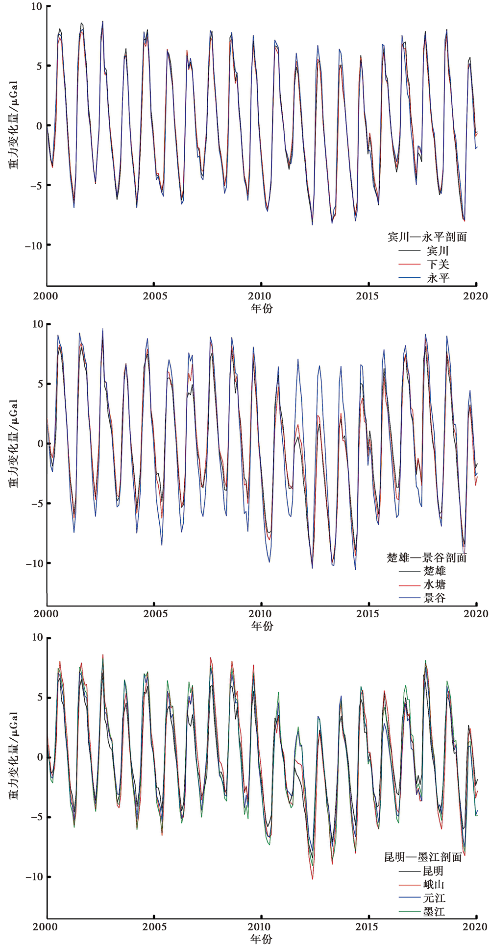
Fig. 5 Gravity effect caused by surface water change in Binchuan-Yongping, Chuxiong-Jinggu and Kunming-Mojiang profiles.
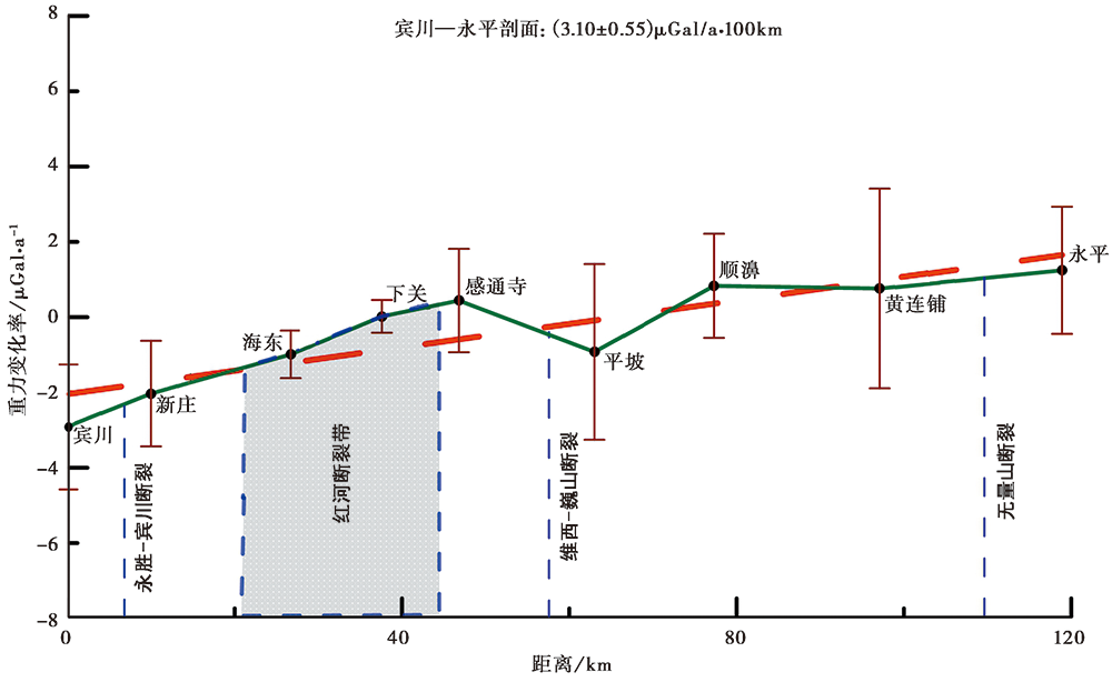
Fig. 6 Long-term gravity change rate of Binchuan-Yongping profile.
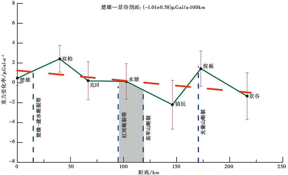
Fig. 7 Long-term gravity change rate of Chuxiong-Jinggu profile.
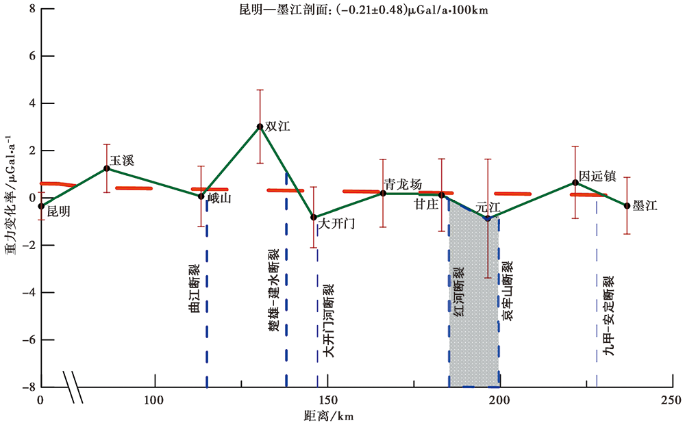
Fig. 8 Long-term gravity change rate of Kunming-Mojiang profile.
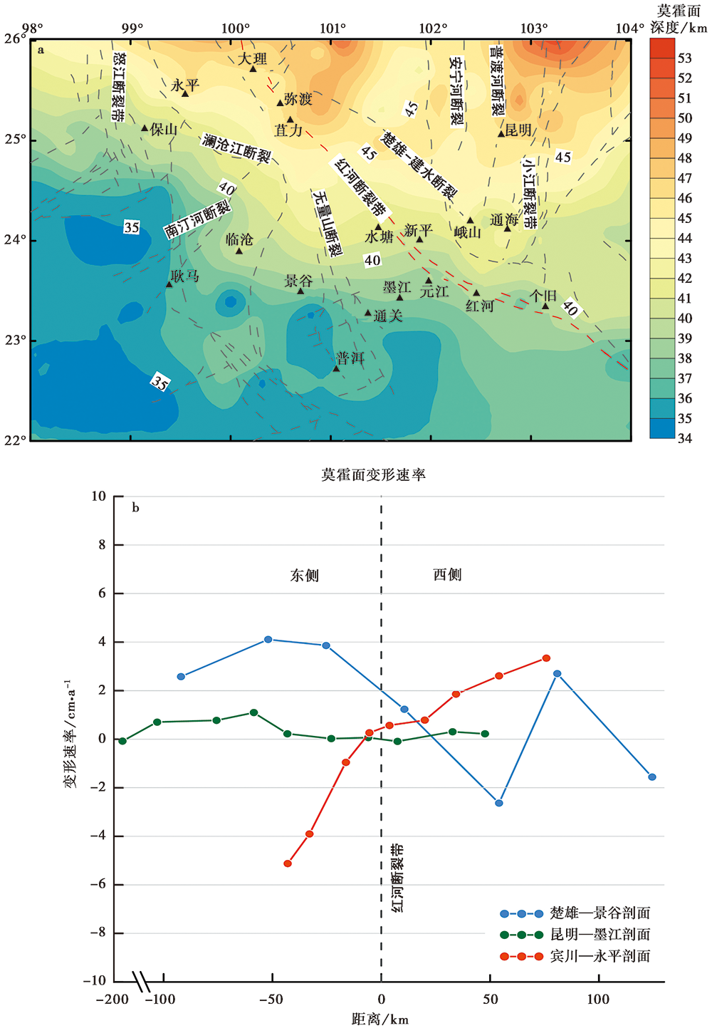
Fig. 9 Depth of Moho(a)and recent Moho deformation rate(b)of the Red River fault zone.
| [1] | 白志明, 王椿镛. 2003. 云南地区上部地壳结构和地震构造环境的层析成像研究[J]. 地震学报, 25(2): 117-127. |
| BAI Zhi-ming, WANG Chun-yong. 2003. Tomographic investigation of the upper crustal structure and seismic tectonic environment in Yunnan Province[J]. Acta Seismologica Sinica, 25(2): 117-127(in Chinese). | |
| [2] | 常祖峰, 常昊, 臧阳, 等. 2016. 维西-乔后断裂新活动特征及其与红河断裂的关系[J]. 地质力学学报, 22(3): 517-530. |
| CHANG Zu-feng, CHANG Hao, ZANG Yang, et al. 2016. Recent active features of Weixi-Qiaohou Fault and its relationship with the Honghe Fault[J]. Journal of Geomechanics, 22(3): 517-530(in Chinese). | |
| [3] | 陈运泰, 顾浩鼎, 卢造勋. 1980. 1975年海城地震与1976年唐山地震前后的重力变化[J]. 地震学报, 2(1): 21-31. |
| CHEN Yun-tai, GU Hao-ding, LU Zao-xun. 1980. Variations of gravity before and after the 1975 Haicheng earthquake and 1976 Tangshan earthquake[J]. Acta Seismologica Sinica, 2(1): 21-31(in Chinese). | |
| [4] |
陈兆辉, 孟小红, 张双喜, 等. 2019. 青藏高原东南缘多尺度重力场变化特征及孕震机理分析[J]. 地震地质, 41(3): 690-703. doi: 10.3969/j.issn.0253-4967.2019.03.010.
DOI |
| CHEN Zhao-hui, MENG Xiao-hong, ZHANG Shuang-xi, et al. 2019. Characteristics of multi-scale gravity field variation and seismogenic mechanism analysis in the southeastern Tibetan plateau[J]. Seismology and Geology, 41(3): 690-703(in Chinese). | |
| [5] | 丁志峰, 何正勤, 孙为国, 等. 1999. 青藏高原东部及其边缘地区的地壳上地幔三维速度结构[J]. 地球物理学报, 42(2): 197-208. |
| DING Zhi-feng, HE Zheng-qin, SUN Wei-guo, et al. 1999. 3-D crust and upper mantle velocity structure in east Tibetan plateau and its surrounding area[J]. Chinese Journal of Geophysics, 42(2): 197-208(in Chinese). | |
| [6] | 虢顺民, 计凤桔, 向宏发, 等. 2001. 红河活动断裂带[M]. 北京: 海洋出版社: 86-108. |
| GUO Shun-min, JI Feng-ju, XIANG Hong-fa, et al. 2001. Honghe Active Fault Zone [M]. China Ocean Press, Beijing:86-108(in Chinese). | |
| [7] | 郝明. 2012. 基于精密水准数据的青藏高原东缘现今地壳垂直运动与典型地震同震及震后垂直形变研究 [D]. 北京: 中国地震局地质研究所:57-61. |
| HAO Ming. 2012. Present-day crustal vertical movement inferred from precise leveling data in eastern margin of Tibetan plateau [D]. Institute of Geology, China Earthquake Administration, Beijing: 57-61(in Chinese). | |
| [8] | 胡鸿翔, 陆涵行, 王椿镛, 等. 1986. 滇西地区地壳结构的爆破地震研究[J]. 地球物理学报, 29(2): 133-144. |
| HU Hong-xiang, LU Han-xing, WANG Chun-yong, et al. 1986. Explosion investigation of the crustal structure in western Yunnan Province[J]. Chinese Journal of Geophysics, 29(2): 133-144(in Chinese). | |
| [9] | 李辉, 申重阳, 孙少安, 等. 2009. 中国大陆近期重力场动态变化图像[J]. 大地测量与地球动力学, 29(3): 1-10. |
| LI Hui, SHEN Chong-yang, SUN Shao-an, et al. 2009. Recent dynamic gravity change in the mainland of China[J]. Journal of Geodesy and Geodynamics, 29(3): 1-10(in Chinese). | |
| [10] | 李亚敏, 徐辉龙, 孙金龙, 等. 2008. 红河断裂带及邻区的震源机制解特征及其反映的断裂活动分段性[J]. 热带海洋学报, 27(2): 32-39. |
| LI Ya-min, XU Hui-long, SUN Jin-long, et al. 2008. Characteristics of focal mechanism solutions of Red River fault zone and their reflection on segmented fault activity[J]. Journal of Tropical Oceanography, 27(2):32-39(in Chinese). | |
| [11] |
李永华, 徐小明, 张恩会, 等. 2014. 青藏高原东南缘地壳结构及云南鲁甸、 景谷地震深部孕震环境[J]. 地震地质, 36(4): 1204-1216. doi: 10.3969/j.issn.0253-4967.2014.04.021.
DOI |
| LI Yong-hua, XU Xiao-ming, ZHANG En-hui, et al. 2014. Three-dimensional crust structure beneath SE Tibetan plateau and its seismotectonic implications for the Ludian and Jinggu earthquakes[J]. Seismology and Geology, 36(4): 1204-1216(in Chinese). | |
| [12] | 刘冬至, 李辉, 刘绍府, 等. 1991. 重力测量资料的处理系统:LGADJ∥地震预报方法实用化研究文集 [G]. 北京: 地震出版社: 339-350. |
| LIU Dong-zhi, LI Hui, LIU Shao-fu, et al. 1991. A management and analysis system of gravity survey data: LGADJ [G]∥Proceedings of Research Symposium of Application of Seismological Prediction Methods. Seismological Press, Beijing: 339-350(in Chinese). | |
| [13] | 陆好健, 李金平, 邵金明, 等. 2018. 基于SBAS-InSAR的红河断裂带南段形变特征研究[J]. 测绘工程, 27(9): 16-20, 25. |
| LU Hao-jian, LI Jin-ping, SHAO Jin-ming, et al. 2018. Deformation characteristics of south branch of Honghe fault zone based on SBAS-InSAR[J]. Engineering of Surveying and Mapping, 27(9): 16-20, 25(in Chinese). | |
| [14] | 申重阳, 李辉. 2007. 研究现今地壳运动和强震机理的一种方法[J]. 地球物理学进展, 22(1): 49-56. |
| SHEN Chong-yang, LI Hui. 2007. A method of analyzing the present crustal movement and the mechanism of strong shocks[J]. Progress in Geophysics, 22(1): 49-56(in Chinese). | |
| [15] | 申重阳, 吴云, 王琪, 等. 2002. 云南地区主要断层运动模型的GPS数据反演[J]. 大地测量与地球动力学, 22(3): 46-51. |
| SHEN Chong-yang, WU Yun, WANG Qi, et al. 2002. GPS data inversion of kinematic model of main faults in Yunnan[J]. Journal of Geodesy and Geodynamics, 22(3): 46-51(in Chinese). | |
| [16] | 孙少安, 郝洪涛, 韦进. 2015. 云南景谷M6.6地震前重力场变化的区域性特征[J]. 大地测量与地球动力学, 35(4): 613-615. |
| SUN Shao-an, HAO Hong-tao, WEI Jin. 2015. Regional characteristics of gravity field change before the Yunnan Jinggu M6.6 earthquake[J]. Journal of Geodesy and Geodynamics, 35(4): 613-615(in Chinese). | |
| [17] | 孙少安, 申重阳, 项爱民. 2009. 红河断裂带北段现今活动的重力效应[J]. 大地测量与地球动力学, 29(3): 11-15. |
| SUN Shao-an, SHEN Chong-yang, XIANG Ai-min. 2009. Gravity effect from present activity of northern segment of Red River fault zone[J]. Journal of Geodesy and Geodynamics, 29(3): 11-15(in Chinese). | |
| [18] | 汪汉胜, 贾路路, Wu P, 等. 2010. 冰川均衡调整对东亚重力和海平面变化的影响[J]. 地球物理学报, 53(11): 2590-2602. |
| WANG Han-sheng, JIA Lu-lu, Wu P, et al. 2010. Effects of global glacial isostatic adjustment on the secular changes of gravity and sea level in East Asia[J]. Chinese Journal of Geophysics, 53(11): 2590-2602(in Chinese). | |
| [19] | 汪汉胜, Wu P, van der Wal W, 等. 2009. 大地测量观测和相对海平面联合约束的冰川均衡调整模型[J]. 地球物理学报, 52(10): 2450-2460. |
| WANG Han-sheng, Wu P, van der Wal W, et al. 2009. Glacial isostatic adjustment model constrained by geodetic measurements and relative sea level[J]. Chinese Journal of Geophysics, 52(10): 2450-2460(in Chinese). | |
| [20] | 汪健, 王安怡, 申重阳, 等. 2015. 南北地震带南段莫霍面重力反演研究[J]. 大地测量与地球动力学, 35(6): 931-935. |
| WANG Jian, WANG An-yi, SHEN Chong-yang, et al. 2015. The gravity inversion of Moho in southern area of north-south earthquake belt[J]. Journal of Geodesy and Geodynamics, 35(6): 931-935(in Chinese). | |
| [21] | 汪一鹏, 沈军, 王琪, 等. 2003. 川滇块体的侧向挤出问题[J]. 地学前缘, 10(特刊): 188-192. |
| WANG Yi-peng, SHEN Jun, WANG Qi, et al. 2003. On the lateral extrusion of the Sichuan-Yunnan block[J]. Earth Science Frontiers, 10(special issue): 188-192(in Chinese). | |
| [22] | 王椿镛, Mooney W D, 王溪莉, 等. 2002. 川滇地区地壳上地幔三维速度结构研究[J]. 地震学报, 24(1): 1-16. |
| WANG Chun-yong, Mooney W D, WANG Xi-li, et al. 2002. Study on 3-D velocity structure of crust and upper mantle in Sichuan-Yunnan region, China[J]. Acta Seismologica Sinica, 24(1): 1-16(in Chinese). | |
| [23] | 王椿镛, 杨文采, 吴建平, 等. 2015. 南北构造带岩石圈结构与地震的研究[J]. 地球物理学报, 58(11): 3867-3901. |
| WANG Chun-yong, YANG Wen-cai, WU Jian-ping, et al. 2015. Study on the lithospheric structure and earthquakes in north-south tectonic belt[J]. Chinese Journal of Geophysics, 58(11): 3867-3901(in Chinese). | |
| [24] | 王夫运, 潘素珍, 刘兰, 等. 2014. 玉溪-临沧剖面宽角地震探测: 红河断裂带及滇南地壳结构研究[J]. 地球物理学报, 57(10): 3247-3258. |
| WANG Fu-yun, PAN Su-zhen, LIU Lan, et al. 2014. Wide angle seismic exploration of Yuxi-Lincang profile: The research of crustal structure of the Red River fault zone and southern Yunnan[J]. Chinese Journal of Geophysics, 57(10): 3247-3258(in Chinese). | |
| [25] | 王国芝, 王成善, 刘登忠, 等. 1999. 滇西高原第四纪以来的隆升和剥蚀[J]. 海洋地质与第四纪地质, 19(4): 67-74. |
| WANG Guo-zhi, WANG Cheng-shan, LIU Deng-zhong, et al. 1999. Uplift and denudation of the western Yunnan plateau in Quaternary[J]. Marine Geology and Quaternary Geology, 19(4): 67-74(in Chinese). | |
| [26] | 闻学泽, 杜方, 龙锋, 等. 2011. 小江和曲江-石屏两断裂系统的构造动力学与强震序列的关联性[J]. 中国科学(D辑), 41(5): 713-724. |
| WEN Xue-ze, DU Fang, LONG Feng, et al. 2011. Tectonic dynamics and correlation of major earthquake sequences of the Xiaojiang and Qujiang-Shiping fault systems[J]. Science in China(Ser D), 41(5): 713-724(in Chinese). | |
| [27] |
向宏发, 虢顺民, 张晚霞, 等. 2007. 红河断裂带南段中新世以来大型右旋位错量的定量研究[J]. 地震地质, 29(1): 52-68. doi: 10.3969/j.issn.0253-4967.2007.01.003.
DOI |
| XIANG Hong-fa, GUO Shun-min, ZHANG Wan-xia, et al. 2007. Quantitative study on the large scale dextral strike-slip offset in the southern segment of the Red River Fault since Miocene[J]. Seismology and Geology, 29(1): 52-68(in Chinese). | |
| [28] | 邢乐林, 王林海, 胡敏章, 等. 2017. 时变重力测量确定青藏高原地壳隆升与增厚速率[J]. 武汉大学学报(信息科学版), 42(5): 569-574. |
| XING Le-lin, WANG Lin-hai, HU Min-zhang, et al. 2017. Determination of crust uplifting and thickening of Qinghai-Tibetan plateau from time-variable gravity measurements[J]. Geomatics and Information Science of Wuhan University, 42(5): 569-574(in Chinese). | |
| [29] | 徐鸣洁, 王良书, 刘建华, 等. 2005. 利用接收函数研究哀牢山-红河断裂带地壳上地幔特征[J]. 中国科学(D辑), 35(8): 729-737. |
| XU Ming-jie, WANG Liang-shu, LIU Jian-hua, et al. 2005. Using receiver functions to study the characteristics of the crust and upper mantle of the Ailaoshan-Honghe fault zone[J]. Science in China(Ser D), 35(8): 729-737(in Chinese). | |
| [30] | 徐文, 许才军, 肖卓辉, 等. 2019. 利用GPS数据反演中国红河断裂带活动特性[J]. 武汉大学学报(信息科学版), 44(5): 706-713. |
| XU Wen, XU Cai-jun, XIAO Zhuo-hui, et al. 2019. Inversion of the activity characteristics of the Red River fault zone using GPS data[J]. Geomatics and Information Science of Wuhan University, 44(5): 706-713(in Chinese). | |
| [31] | 徐锡伟, 闻学泽, 郑荣章, 等. 2003. 川滇地区活动块体最新构造变动样式及其动力来源[J]. 中国科学(D辑), 33(S1): 151-161. |
| XU Xi-wei, WEN Xue-ze, ZHENG Rong-zhang, et al. 2003. Pattern of latest tectonic motion and its dynamics for active blocks in Sichuan-Yunnan region, China[J]. Science in China(Ser D), 33(S1): 151-161(in Chinese). | |
| [32] | 胥颐, 刘建华, 刘福元, 等. 2003. 哀牢山-红河断裂带及其邻区的地壳上地幔结构[J]. 中国科学(D辑), 33(12): 1202-1208. |
| XU Yi, LIU Jian-hua, LIU Fu-yuan, et al. 2003. 3-D crustal and upper mantle structure of the Ailaoshan-Honghe fault zone and its adjacent areas[J]. Science in China(Ser D), 33(12): 1202-1208(in Chinese). | |
| [33] | 徐震, 徐鸣洁, 王良书, 等. 2006. 用接收函数Ps 转换波研究地壳各向异性: 以哀牢山-红河断裂带为例[J]. 地球物理学报, 49(2): 438-448. |
| XU Zhen, XU Ming-jie, WANG Liang-shu, et al. 2006. A study on crustal anisotropy using P to S converted phase of the receiver function: Application to Ailaoshan-Red River fault zone[J]. Chinese Journal of Geophysics, 49(2): 438-448(in Chinese). | |
| [34] |
杨婷, 吴建平, 房立华, 等. 2014. 滇西地区地壳速度结构及其构造意义[J]. 地震地质, 36(2): 392-404. doi: 10.3969/j.issn.0253-4967.2014.02.010.
DOI |
| YANG Ting, WU Jian-ping, FANG Li-hua, et al. 2014. 3-D crustal P-wave velocity structure in western Yunnan area and its tectonic implications[J]. Seismology and Geology, 36(2): 392-404(in Chinese). | |
| [35] | 张建国. 2009. 中越红河断裂活动性研究[D]. 合肥: 中国科学技术大学: 163-166. |
| ZHANG Jian-guo. 2009. Research on the Red River Fault in China and Vietnam[D]. University of Science and Technology of China, Hefei: 163-166(in Chinese). | |
| [36] | 张培震, 王敏, 甘卫军, 等. 2003. GPS观测的活动断裂滑动速率及其对现今大陆动力作用的制约[J]. 地学前缘, 10(特刊): 81-92. |
| ZHANG Pei-zhen, WANG Min, GAN Wei-jun, et al. 2003. Slip rates along major active faults from GPS measurements and constraints on contemporary continental tectonics[J]. Earth Science Frontiers, 10(Special issue): 81-92(in Chinese). | |
| [37] | 周江存, 孙和平, 徐建桥. 2009. 用地表和空间重力测量验证全球水储量变化模型[J]. 科学通报, 54(9): 1282-1289. |
| ZHOU Jiang-cun, SUN He-ping, XU Jian-qiao. 2009. Validating global hydrological models by ground and space gravimetry[J]. Chinese Science Bulletin, 54(9): 1282-1289(in Chinese). | |
| [38] | 祝意青, 梁伟锋, 湛飞并, 等. 2012. 中国大陆重力场动态变化研究[J]. 地球物理学报, 55(3): 804-813. |
| ZHU Yi-qing, LIANG Wei-feng, ZHAN Fei-bing, et al. 2012. Study on dynamic change of gravity field in China continent[J]. Chinese Journal of Geophysics, 55(3): 804-813(in Chinese). | |
| [39] |
Farrell W E. 1972. Deformation of the earth by surface loads[J]. Reviews of Geophysics and Space Physics, 10(3): 761-797.
DOI URL |
| [40] |
Hao M, Freymueller J T, Wang Q, et al. 2016. Vertical crustal movement around the southeastern Tibetan plateau constrained by GPS and GRACE data[J]. Earth and Planetary Science Letters, 437:1-8.
DOI URL |
| [41] |
Hao M, Wang Q L, Shen Z K, et al. 2014. Present day crustal vertical movement inferred from precise leveling data in eastern margin of Tibetan plateau[J]. Tectonophysics, 632:281-292.
DOI URL |
| [42] |
Jiao J S, Zhang Y Z, Yin P, et al. 2019. Changing Moho beneath the Tibetan plateau revealed by GRACE observations[J]. Journal of Geophysical Research: Solid Earth, 124(6): 5907-5923.
DOI URL |
| [43] |
Kaufmann G. 2005. Geodetic signatures of a Late Pleistocene Tibetan ice sheet[J]. Journal of Geodynamics, 39(2): 111-125.
DOI URL |
| [44] | Lal D, Harris N B W, Sharma K K, et al. 2004. Erosion history of the Tibetan plateau since the last interglacial: Constraints from the first studies of cosmogenic 10Be from Tibetan bedrock[J]. Earth & Planetary Science Letters, 217(1): 33-42. |
| [45] |
Leloup P H, Lacassin R, Tapponnier P, et al. 1995. The Ailao Shan-Red River shear zone(Yunnan, China), Tertiary transform boundary of IndoChina[J]. Tectonophysics, 251(14): 3-10.
DOI URL |
| [46] | Liang S M, Gan W J, Shen C Z, et al. 2013. Three-dimensional velocity field of present-day crustal motion of the Tibetan plateau derived from GPS measurements[J]. Journal of Geophysical Research, 118(10): 5722-5732. |
| [47] |
Métivier F, Gaudemer Y, Tapponnier P, et al. 1999. Mass accumulation rates in Asia during the Cenozoic[J]. Geophysical Journal International, 137(2): 280-318.
DOI URL |
| [48] |
Molnar P, Tapponnier P. 1975. Cenozoic tectonics of Asia: Effects of a continental collision[J]. Science, 189(4201): 419-426.
PMID |
| [49] |
Oldenburg D W. 1974. The inversion and interpretation of gravity anomalies[J]. Geophysics, 39(4): 526-536.
DOI URL |
| [50] | Pan Y J, Shen W B, Shum C K, et al. 2018. Spatially varying surface seasonal oscillations and 3-D crustal deformation of the Tibetan plateau derived from GPS and GRACE data[J]. Earth and Planetary Science Letters, 52:12-22. |
| [51] |
Parker R L. 1973. The rapid calculation of potential anomalies[J]. Geophysical Journal International, 31(4): 447-455.
DOI URL |
| [52] | Rao W L, Sun W K. 2021. Moho interface changes beneath the Tibetan plateau based on GRACE data[J]. Journal of Geophysical Research: Solid Earth, 126(2): 1-14. |
| [53] |
Rodell M, Houser P R, Jambor U, et al. 2004. The global land data assimilation system[J]. Bulletin of the American Meteorological Society, 85(3): 381-394.
DOI URL |
| [54] |
Royden L H, Burchfiel B C, van der Hilst R D. 2008. The geological evolution of the Tibetan plateau[J]. Science, 321(5892): 1054-1058.
DOI PMID |
| [55] | Sun W K, Wang Q, Li H, et al. 2009. Gravity and GPS measurements reveal mass loss beneath the Tibetan plateau: Geodetic evidence of increasing crustal thickness[J]. Geophysical Research Letter, 36(2): L02303. |
| [56] |
Sun W K, Wang Q, Li H, et al. 2011. A reinvestigation of crustal thickness in the Tibetan plateau using absolute gravity, GPS, and GRACE data[J]. Terrestrial Atmospheric and Oceanic Sciences, 22(2): 109-119.
DOI URL |
| [57] |
Tapponnier P, Xu Z Q, Roger F, et al. 2001. Oblique stepwise rise and growth of the Tibet Plateau[J]. Science, 294(5547): 1671-1677.
PMID |
| [58] |
Wang H S. 2001. Effects of glacial isostatic adjustment since the late Pleistocene on the uplift of the Tibetan plateau[J]. Geophysical Journal International, 144(2): 448-458.
DOI URL |
| [59] |
Wang W L, Wu J P, Fang L H, et al. 2017. Crustal thickness and Poisson's ratio in southwest China based on data from dense seismic arrays[J]. Journal of Geophysical Research: Solid Earth, 122(9): 7219-7235.
DOI URL |
| [60] | Westaway R. 1995. Crustal volume balance during the India-Eurasia collision and altitude of the Tibetan plateau: A working hypothesis[J]. Journal of Geophysical Research: Solid Earth, 100(B8): 15173-15192. |
| [61] |
Xing L L, Li H, Li J C, et al. 2009. Comparison of absolute gravity measurements obtained with FG5/232 and FG5/214 instruments[J]. Geo-spatial Information Science, 12(4): 307-310.
DOI URL |
| [62] |
Yi S, Jeffrey T, Sun W K. 2016. How fast is the middle-lower crust flowing in eastern Tibet?A constraint from geodetic observations[J]. Journal of Geophysical Research: Solid Earth, 121(9): 6903-6915.
DOI URL |
| [63] |
Zhang P Z, Shen Z K, Wang M, et al. 2004. Continuous deformation of the Tibetan plateau from global positioning system data[J]. Geology, 32(9): 809-812.
DOI URL |
| [1] | WANG Jian, ZHANG Xin-lin, TAN Hong-bo, HU Min-zhang, WU Gui-ju, LI Zhong-ya, ZHANG Ming-hui. DETERMINATION OF GRAVITY VALUES FOR MULANSHAN CALIBRATION BASELINE AND ANALYSIS OF GRAVITY CHANGE [J]. SEISMOLOGY AND GEOLOGY, 2023, 45(2): 553-569. |
| [2] | LIU Yi-jun, YANG Guang-liang, WANG Jia-pei, TAN Hong-bo, ZHOU Huai-bin, SHEN Chong-yang. INVERSION OF INDOSINIAN SURFACE IN CHANGNING, SICHUAN BASED ON PARTICLE SWARM OPTIMIZATION ALGORITHM [J]. SEISMOLOGY AND GEOLOGY, 2023, 45(1): 172-189. |
| [3] | GUO Shu-song, ZHU Yi-qing, XU Yun-ma, LIU Fang, ZHAO Yun-feng, ZHANG Guo-qing, ZHU Hui. GRAVITY EVIDENCE OF META-INSTABLE STATE BEFORE THE 2008 WENCHUAN EARTHQUAKE [J]. SEISMOLOGY AND EGOLOGY, 2021, 43(6): 1368-1380. |
| [4] | LIU Dong, HAO Hong-tao, WANG Qing-hua, ZHENG Qiu-yue, HUANG Jiang-pei. GRAVITY FIELD CHANGE BEFORE THE 2021 YANGBI MS6.4 EARTHQUAKE, YUNNAN [J]. SEISMOLOGY AND EGOLOGY, 2021, 43(5): 1157-1170. |
| [5] | XU Xiao-xue, JI Ling-yun, ZHU Liang-yu, WANG Guang-ming, ZHANG Wen-ting, LI Ning. THE CO-SEISMIC DEFORMATION CHARACTERISTICS AND SEISMOGENIC STRUCTURE OF THE YANGBI MS6.4 EARTHQUAKE [J]. SEISMOLOGY AND EGOLOGY, 2021, 43(4): 771-789. |
| [6] | TAN Hong-bo, WANG Jia-pei, YANG Guang-liang, CHEN Zheng-song, WU Gui-ju, SHEN Chong-yang, HUANG Jin-shui. SIMULATION OF POST-SEISMIC EFFECTS OF THE MADUO MS7.4 EARTHQUAKE IN 2021 [J]. SEISMOLOGY AND EGOLOGY, 2021, 43(4): 936-957. |
| [7] | ZHANG Xin-lin, WANG Jian, HU Min-zhang, WANG Jia-pei, LI Zhong-ya, ZHANG Yi. GRAVITY VARIATION CHARACTERISTICS IN YUNNAN AND ITS SURROUNDING AREAS FROM 2010 TO 2020 [J]. SEISMOLOGY AND EGOLOGY, 2021, 43(4): 972-983. |
| [8] | WEI Jin, HAO Hong-tao, HAN Yu-fei, HU Min-zhang, JIANG Ying, LIU Zi-wei. STUDY ON THE CHARACTERISTICS OF CO-SEISMIC GRAVITY CHANGE INDUCED BY MADUO MS7.4 EARTHQUAKE BASED ON OBSERVATIONS OF CONTINUOUS GRAVITY STATIONS [J]. SEISMOLOGY AND EGOLOGY, 2021, 43(4): 984-998. |
| [9] | WEN Xiang, ZHOU Bin, SHI Shui-ping, QIN Jian, LI Jia-ning, HE Yan, YAN Chun-heng, LUO Yuan-peng. COMPREHENSIVE ANALYSIS OF RECENT GRAVITY AND CRUSTAL DEFORMATION IN NORTHWESTERN GUANGXI [J]. SEISMOLOGY AND GEOLOGY, 2019, 41(4): 927-943. |
| [10] | DAI Wen-hao, ZHOU Yong-sheng. DEFORMATION OF THE BRITTLE-PLASTIC TRANSITION ZONE AT THE POST-SEISMIC RELAXATION PERIOD: A CASE STUDY OF THE RED RIVER FAULT [J]. SEISMOLOGY AND GEOLOGY, 2019, 41(4): 996-1011. |
| [11] | ZHU Yi-qing, LIANG Wei-feng, HAO Ming, ZHAO Ling-qiang, HAO Qing-hua, ZHANG Guo-qing, LIU Lian. THE COMPREHENSIVE ANALYSIS AND RESEARCH OF RECENT GRAVITY AND CRUSTAL DEFORMATION IN NORTHEASTERN EDGE OF THE TIBETAN PLATEAU [J]. SEISMOLOGY AND GEOLOGY, 2017, 39(4): 768-780. |
| [12] | LI Xi, RAN Yong-kang, CHEN Li-chun, WANG Hu, YU Jiang, ZHANG Yan-qi, XIE Ying-qing. THE HOLOCENE SEISMIC EVIDENCE ON SOUTHERN SEGMENT OF THE RED RIVER FAULT ZONE [J]. SEISMOLOGY AND GEOLOGY, 2016, 38(3): 596-604. |
| [13] | CHEN Si-wen, WANG Bao-shan, TIAN Xiao-feng, WANG Fu-yun, LIU Bao-feng, LI Lu. CRUSTAL STRUCTURE FROM YUNXIAN-NINGLANG WIDE-ANGLE SEISMIC REFLECTION AND REFRACTION PROFILE IN NORTHWESTERN YUNNAN, CHINA [J]. SEISMOLOGY AND GEOLOGY, 2016, 38(1): 91-106. |
| [14] | ZHU Yi-qing, FU Guang-yu, LIANG Wei-feng, XU Yun-ma. EARTHQUAKE PREDICTIONS: SPATIAL-TEMPORAL GRAVITY CHANGES BEFORE THE LUDIAN MS6.5, LUSHAN MS7.0 AND WENCHUAN MS8.0 EARTHQUAKES [J]. SEISMOLOGY AND GEOLOGY, 2015, 37(1): 319-330. |
| [15] | SHI Lei, JIA Xiao-dong, CHEN Shi, XU Wei-min, LU Hong-yan. GRAVITY CHANGES BEFORE THE LUDIAN, YUNNAN, MS6.5 EARTHQUAKE OF 2014 AND THE THREE-DIMENSIONAL INVERSION RESEARCH [J]. SEISMOLOGY AND GEOLOGY, 2014, 36(4): 1217-1227. |
| Viewed | ||||||
|
Full text |
|
|||||
|
Abstract |
|
|||||
