SEISMOLOGY AND GEOLOGY ›› 2022, Vol. 44 ›› Issue (2): 524-540.DOI: 10.3969/j.issn.0253-4967.2022.02.015
• Focus: Mechanical understanding of the surface ruptures of the 2021 Madoi earthquake • Previous Articles Next Articles
WANG Wen-xin1)( ), SHAO Yan-xiu1),*(), YAO Wen-qian1), LIU-ZENG Jing1,2), HAN Long-fei1), LIU Xiao-li3), GAO Yun-peng1), WANG Zi-jun1), QIN Ke-xin1), TU Hong-wei4)
Received:2022-01-25
Revised:2022-03-19
Online:2022-04-20
Published:2022-06-14
Contact:
SHAO Yan-xiu
王文鑫1)(), 邵延秀1),*(), 姚文倩1), 刘静1,2), 韩龙飞1), 刘小利3), 高云鹏1), 王子君1), 秦可心1), 屠泓为4)
通讯作者:
邵延秀
作者简介:王文鑫, 男, 1995年生, 现为天津大学地球系统科学学院环境科学专业在读博士研究生, 主要从事地表侵蚀与地貌演化方面的研究, E-mail: wenxinwwx_1995@tju.edu.cn。
基金资助:CLC Number:
WANG Wen-xin, SHAO Yan-xiu, YAO Wen-qian, LIU-ZENG Jing, HAN Long-fei, LIU Xiao-li, GAO Yun-peng, WANG Zi-jun, QIN Ke-xin, TU Hong-wei. RAPID EXTRACTION OF FEATURES AND INDOOR RECON-STRUCTION OF 3D STRUCTURES OF MADOI MW7.4 EARTHQUAKE SURFACE RUPTURES BASED ON PHOTOGRAMMETRY METHOD[J]. SEISMOLOGY AND GEOLOGY, 2022, 44(2): 524-540.
王文鑫, 邵延秀, 姚文倩, 刘静, 韩龙飞, 刘小利, 高云鹏, 王子君, 秦可心, 屠泓为. 基于摄影测量技术对玛多MW7.4地震地表破裂特征的快速提取及三维结构的室内重建[J]. 地震地质, 2022, 44(2): 524-540.
Add to citation manager EndNote|Ris|BibTeX
URL: https://www.dzdz.ac.cn/EN/10.3969/j.issn.0253-4967.2022.02.015
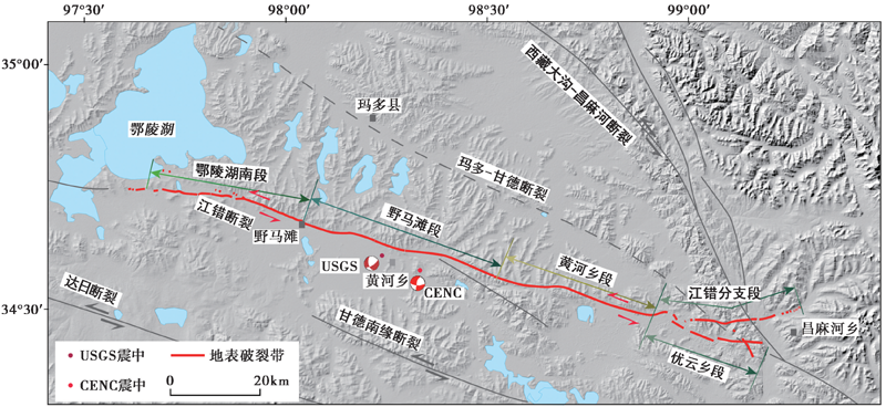
Fig. 1 Seismogenic tectonic background map of the Madoi MW7.4 earthquake.
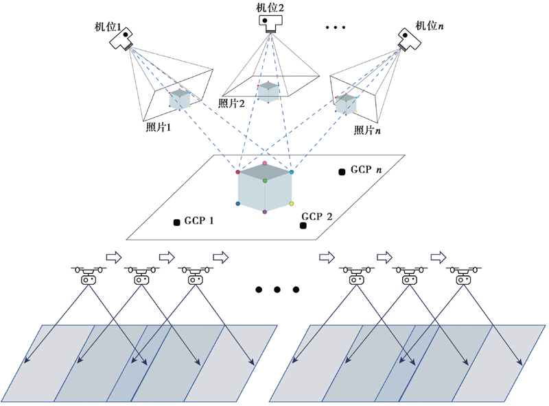
Fig. 2 Basic principle of SfM method(adapted after Westoby et al., 2012; BI Hai-yun et al., 2017).
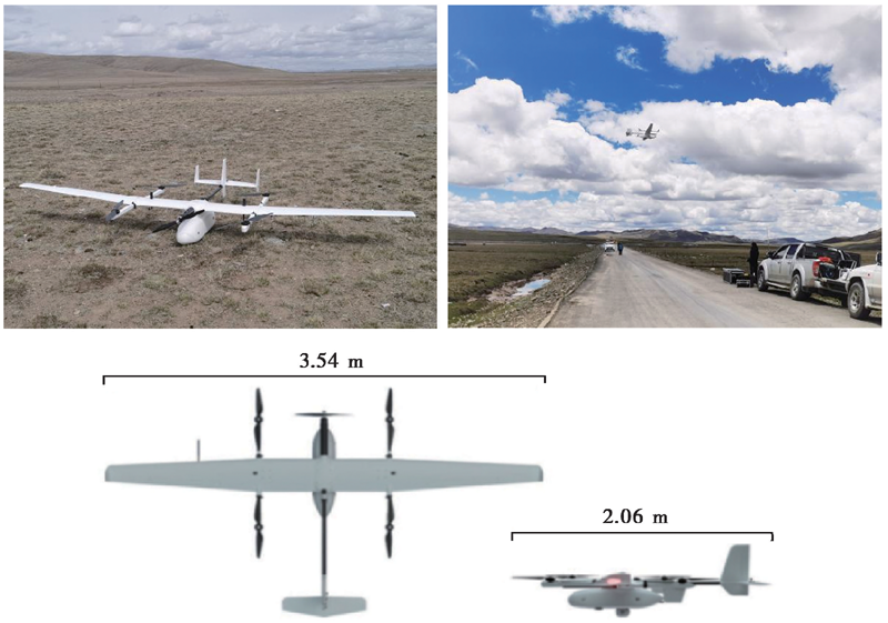
Fig. 3 Appearance and field operation diagram of CW-15 VTOL fixed-wing UAV.
| 指标 | 参数 |
|---|---|
| 机身长度/翼展 | 2.06m/3.54m |
| 最大起飞重量 | 17kg |
| 任务载荷 | ≤3kg |
| 带载续航能力 | 120~180min |
| 抗风能力 | 6级(10.8~13.8m/s) |
| 起飞海拔/实用升限 | 4500m/6500m |
| 垂直方向定位精度 | 3cm |
| 水平方向定位精度 | 1cm+1ppm |
| 影像传感器 | CA103全画幅正射相机+DS100旋偏云台 |
Table1 Main parameters of CW-15 VTOL fixed-wing UAV system
| 指标 | 参数 |
|---|---|
| 机身长度/翼展 | 2.06m/3.54m |
| 最大起飞重量 | 17kg |
| 任务载荷 | ≤3kg |
| 带载续航能力 | 120~180min |
| 抗风能力 | 6级(10.8~13.8m/s) |
| 起飞海拔/实用升限 | 4500m/6500m |
| 垂直方向定位精度 | 3cm |
| 水平方向定位精度 | 1cm+1ppm |
| 影像传感器 | CA103全画幅正射相机+DS100旋偏云台 |
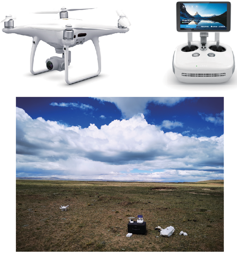
Fig. 4 Appearance and field operation diagram of DJI Phantom 4 Pro V2.0 UAV.
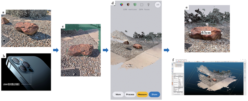
Fig. 5 Schematic diagram of AR imaging for iPhone 12 Pro LiDAR scanner(Image data from webpage①).
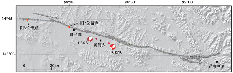
Fig. 6 Coverage area of CW-15 UAV aerial orthophoto image.
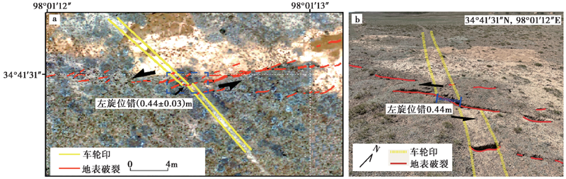
Fig. 7 Image interpretation(a)and field measurement(b)of left-lateral offset in motorcycle wheel mark.
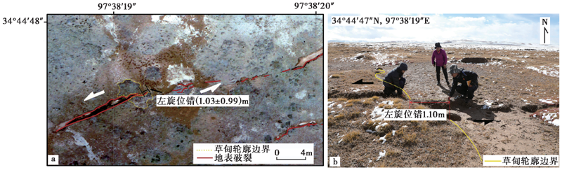
Fig. 8 Image interpretation(a)and field measurement(b)of left-lateral offset in meadow.
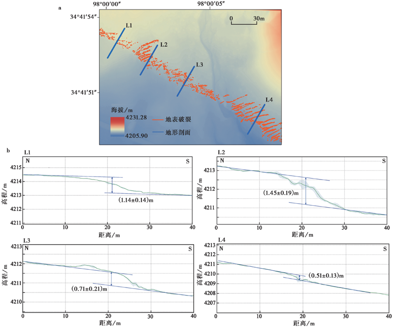
Fig. 9 High-precision region DEM(a)and vertical offset(b)obtained by UAV photogrammetry.
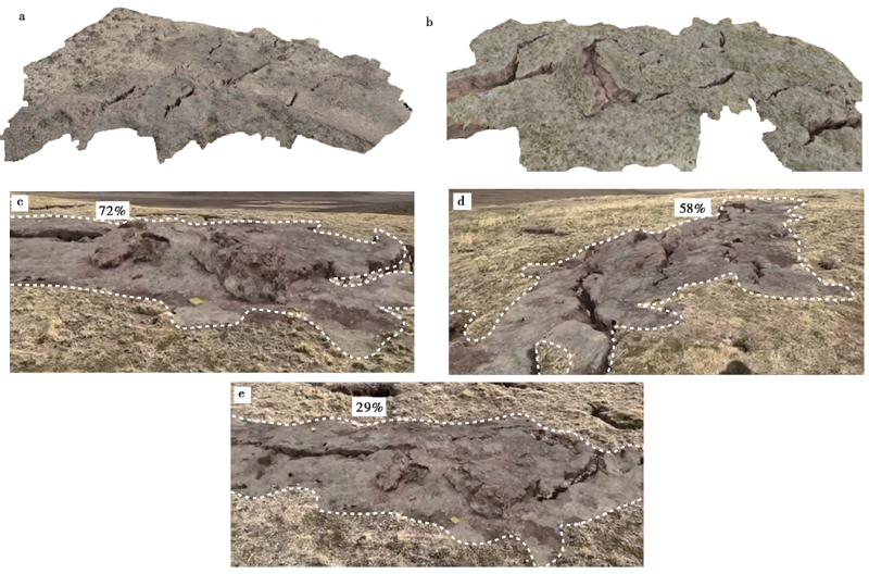
Fig. 10 AR imaging of surface ruptures and pressure ridges.
| [1] |
艾明, 毕海芸, 郑文俊, 等. 2018. 利用无人机摄影测量技术提取活动构造定量参数[J]. 地震地质, 40(6): 1276-1293. doi: 10.3969/j.issn.0253-4967.2018.06.006.
DOI |
| AI Ming, BI Hai-yun, ZHENG Wen-jun,et al. 2018. Using unmanned aerial vehicle photogrammetry technology to obtain quantitative parameters of active tectonics[J]. Seismology and Geology, 40(6): 1276-1293. (in Chinese) | |
| [2] |
毕海芸, 郑文俊, 曾江源, 等. 2017. SfM摄影测量方法在活动构造定量研究中的应用[J]. 地震地质, 39(4): 656-674. doi: 10.3969/j.issn.0253-4967.2017.04.003.
DOI |
| BI Hai-yun, ZHENG Wen-jun, ZENG Jiang-yuan,et al. 2017. Application of SfM photogrammetry method to the quantitative study of active tectonics[J]. Seismology and Geology, 39(4): 656-674. (in Chinese) | |
| [3] | 陈桂华, 徐锡伟, 闻学泽, 等. 2006. 数字航空摄影测量学方法在活动构造中的应用[J]. 地球科学(中国地质大学学报), 31(3): 405-410. |
| CHEN Gui-hua, XU Xi-wei, WEN Xue-ze,et al. 2006. Application of digital aerophotogrammetry in active tectonics[J]. Earth Science(Journal of China University of Geosciences), 31(3): 405-410. (in Chinese) | |
| [4] | 陈晓勇, 何海清, 周俊超, 等. 2019. 低空摄影测量立体影像匹配的现状与展望[J]. 测绘学报, 48(12): 1595-1603. |
| CHEN Xiao-yong, HE Hai-qing, ZHOU Jun-chao,et al. 2019. Progress and future of image matching in low-altitude photogrammetry[J]. Acta Geodaetica et Cartographica Sinica, 48(12): 1595-1603. (in Chinese) | |
| [5] | 程争刚, 张利. 2016. 一种基于无人机位姿信息的航拍图像拼接方法[J]. 测绘学报, 45(6): 698-705. |
| CHENG Zheng-gang, ZHANG Li. 2016. An aerial image mosaic method based on UAV position and attitude information[J]. Acta Geodaetica et Cartographica Sinica, 45(6): 698-705. (in Chinese) | |
| [6] | 邓起东, 陈立春, 冉勇康. 2004. 活动构造定量研究与应用[J]. 地学前缘, 11(4): 383-392. |
| DENG Qi-dong, CHEN Li-chun, RAN Yong-kang. 2004. Quantitative studies and applications of active tectonics[J]. Earth Science Frontiers, 11(4): 383-392. (in Chinese) | |
| [7] | 盖海龙, 姚生海, 杨丽萍, 等. 2021. 青海玛多“5·22” MS7.4 地震的同震地表破裂特征、 成因及意义[J]. 地质力学学报, 27(6): 899-912. |
| GAI Hai-long, YAO Sheng-hai, YANG Li-ping,et al. 2021. Characteristics and causes of coseismic surface rupture triggered by the “5·22” MS7.4 earthquake in Maduo, Qinghai, and their significance[J]. Journal of Geomechanics, 27(6): 899-912. (in Chinese) | |
| [8] | 龚健雅, 季顺平. 2018. 摄影测量与深度学习[J]. 测绘学报, 47(6): 693-704. |
| GONG Jian-ya, JI Shun-ping. 2018. Photogrammetry and deep learning[J]. Acta Geodaetica et Cartographica Sinica, 47(6): 693-704. (in Chinese) | |
| [9] | 韩龙飞, 刘静, 姚文倩, 等. 2022. 2021年玛多MW7.4地震震中区地表破裂的精细填图及阶区内分布式破裂的讨论[J]. 地震地质, 44(2): 484-505. |
| HAN Long-fei, LIU-ZENG Jing, YAO Wen-qian,et al. 2022. Detailed mapping of the surface rupture near the epicenter segment of the 2021 Madoi MW7.4 earthquake and discussion on distributed rupture in the step-over[J]. Seismology and Geology, 44(2): 484-505. (in Chinese) | |
| [10] |
李智敏, 李文巧, 李涛, 等. 2021. 2021年5月22日青海玛多 MS7.4 地震的发震构造和地表破裂初步调查[J]. 地震地质, 43(3): 722-737. doi: 10.3969/j.issn.0253-4967.2021.03.016.
DOI |
| LI Zhi-min, LI Wen-qiao, LI Tao,et al. 2021. Seismogenic fault and coseismic surface deformation of the Maduo MS7.4 earthquake in Qinghai, China: A quick report[J]. Seismology and Geology, 43(3): 722-737. (in Chinese) | |
| [11] | 刘静, 陈涛, 张培震, 等. 2013. 机载激光雷达扫描揭示海原断裂带微地貌的精细结构[J]. 科学通报, 58(1): 41-45. |
| LIU-ZENG Jing, CHEN Tao, ZHANG Pei-zhen,et al. 2013. Illuminating the active Haiyuan Fault, China by airborne light detection and ranging[J]. Chinese Science Bulletin, 58(1): 41-45. (in Chinese) | |
| [12] | 刘静, 张金玉, 葛玉魁, 等. 2018. 构造地貌学: 构造-气候-地表过程相互作用的交叉研究[J]. 科学通报, 63(30): 3070-3088. |
| LIU-ZENG Jing, ZHANG Jin-yu, GE Yu-kui,et al. 2018. Tectonic geomorphology: An interdisciplinary study of the interaction among tectonic climatic and surface processes[J]. Chinese Science Bulletin, 63(30): 3070-3088. (in Chinese) | |
| [13] |
刘小利, 夏涛, 刘静, 等. 2022. 2021年青海玛多 MW7.4 地震分布式同震地表裂缝特征[J]. 地震地质, 44(2): 461-483. doi: 10.3969/j.issn.0253-4967.2022.02.012.
DOI |
| LIU Xiao-li, XIA Tao, LIU-ZENG Jing,et al. 2022. Distributed characteristics of the surface deformations associated with the 2021 MW7.4 Madoi earthquake, Qinghai, China[J]. Seismology and Geology, 44(2): 461-483. (in Chinese) | |
| [14] | 潘家伟, 白明坤, 李超, 等. 2021. 2021年5月22日青海玛多 MS7.4 地震地表破裂带及发震构造[J]. 地质学报, 95(6): 1655-1670. |
| PAN Jia-wei, BAI Ming-kun, LI Chao,et al. 2021. Coseismic surface rupture and seismogenic structure of the 2021-05-22 Maduo MS7.4 earthquake[J]. Acta Geologica Sinica, 95(6): 1655-1670. (in Chinese) | |
| [15] | 邵延秀, 刘静, 高云鹏, 等. 2022. 同震地表破裂的位移测量与弥散变形分析--以2021年青海玛多 MW7.4 地震为例[J]. 地震地质, 44(2): 506-523. |
| SHAO Yan-xiu, LIU-ZENG Jing, GAO Yun-peng,et al. 2022. Coseismic displacement measurement and distributed deformation characterization: A case of 2021 MW7.4 Madoi earthquake[J]. Seismology and Geology, 44(2): 506-523. (in Chinese) | |
| [16] |
魏占玉, Ramon A, 何宏林, 等. 2015. 基于SfM方法的高密度点云数据生成及精度分析[J]. 地震地质, 37(2): 636-648. doi: 10.3969/j.issn.0253-4967.2015.02.024.
DOI |
| WEI Zhan-yu, Ramon A, HE Hong-lin,et al. 2015. Accuracy analysis of terrain point cloud acquired by “Structure from Motion” using aerial photos[J]. Seismology and Geology, 37(2): 636-648. (in Chinese) | |
| [17] |
姚生海, 盖海龙, 殷翔, 等. 2021. 青海玛多 MS7.4 地震地表破裂带的基本特征和典型现象[J]. 地震地质, 43(5): 1060-1072. doi: 10.3969/j.issn.0253-4967.2021.05.002.
DOI |
| YAO Sheng-hai, GAI Hai-long, YIN Xiang,et al. 2021. The basic characteristics and typical phenomena of the surface rupture zone of the Maduo MS7.4 earthquake in Qinghai[J]. Seismology and Geology, 43(5): 1060-1072. (in Chinese) | |
| [18] | 姚文倩, 王子君, 刘静, 等. 2022. 2021年青海玛多 MW7.4 地震同震地表破裂长度的讨论[J]. 地震地质, 44(2): 541-559. |
| YAO Wen-qian, WANG Zi-jun, LIU-ZENG Jing,et al. 2022. Discussion on coseismic surface rupture length of the 2021 MW7.4 Madoi earthquake, Qinghai, China[J]. Seismology and Geology, 44(2): 541-559. (in Chinese) | |
| [19] | 张春森, 张卫龙, 郭丙轩, 等. 2015. 倾斜影像的三维纹理快速重建[J]. 测绘学报, 44(7): 782-790. |
| ZHANG Chun-sen, ZHANG Wei-long, GUO Bing-xuan,et al. 2015. Rapidly 3D texture reconstruction based on oblique photography[J]. Acta Geodaetica et Cartographica Sinica, 44(7): 782-790. (in Chinese) | |
| [20] | 张剑清, 潘励, 王树根. 2009. 摄影测量学[M]. 武汉: 武汉大学出版社. |
| ZHANG Jian-qing, PAN Li, WANG Shu-gen. 2009. Photogrammetry[M]. Wuhan University Press, Wuhan. (in Chinese) | |
| [21] | 赵红蕊, 陆胜寒. 2018. 基于特征尺度分布与对极几何约束的高清影像快速密集匹配方法[J]. 测绘学报, 47(6): 790-798. |
| ZHAO Hong-rui, LU Sheng-han. 2018. Dense high-definition image matching strategy based on scale distribution of feature and geometric constraint[J]. Acta Geodaetica et Cartographica Sinica, 47(6): 790-798. (in Chinese) | |
| [22] |
Ajayi O G, Salubi A A, Angbas A F,et al. 2017. Generation of accurate digital elevation models from UAV acquired low percentage overlapping images[J]. International Journal of Remote Sensing, 38(8-10): 3113-3134.
DOI URL |
| [23] |
Arrowsmith J R, Zielke O, Tarolli P,et al. 2009. Tectonic geomorphology of the San Andreas fault zone from high resolution topography: An example from the Cholame segment[J]. Geomorphology, 113(1-2): 70-81.
DOI URL |
| [24] | Bemis S P, Micklethwaite S, Turner D,et al. 2014. Ground-based and UAV-based photogrammetry: A multi-scale, high-resolution mapping tool for structural geology and paleoseismology[J]. Journal of Structural Geology, 69(Part A): 163-178. |
| [25] |
Bi H Y, Zheng W J, Ren Z K,et al. 2017. Using an unmanned aerial vehicle for topography mapping of the fault zone based on structure from motion photogrammetry[J]. International Journal of Remote Sensing, 38(8-10): 2495-2510.
DOI URL |
| [26] | Fonstad M A, Dietrich J T, Courville B C,et al. 2013. Topographic structure from motion: A new development in photogrammetric measurement[J]. Earth Surface Processes & Landforms, 38(4): 421-430. |
| [27] |
Fraser C S, Cronk S. 2009. A hybrid measurement approach for close-range photogrammetry[J]. ISPRS Journal of Photogrammetry and Remote Sensing, 64(3): 328-333.
DOI URL |
| [28] |
Giordan D, Adams M S, Aicardi I,et al. 2020. The use of unmanned aerial vehicles(UAVs)for engineering geology applications[J]. Bulletin of Engineering Geology and the Environment, 79(7): 3437-3481.
DOI URL |
| [29] |
Harwin S, Lucieer A. 2012. Assessing the accuracy of georeferenced point clouds produced via multi-view stereopsis from unmanned aerial vehicle(UAV)imagery[J]. Remote Sensing, 4(6): 1573-1599.
DOI URL |
| [30] |
James M R, Robson S, d'Oleire-Oltmanns S,et al. 2017. Optimising UAV topographic surveys processed with structure-from-motion: Ground control quality, quantity and bundle adjustment[J]. Geomorphology, 280:51-66.
DOI URL |
| [31] |
Javernick L, Brasington J, Caruso B. 2014. Modeling the topography of shallow braided rivers using Structure-from-Motion photogrammetry[J]. Geomorphology, 213:166-182.
DOI URL |
| [32] |
Johnson K, Nissen E, Saripalli S,et al. 2014. Rapid mapping of ultrafine fault zone topography with structure from motion[J]. Geosphere, 10(5): 969-986.
DOI URL |
| [33] |
Lin Z, Kaneda H, Mukoyama S,et al. 2013. Detection of subtle tectonic-geomorphic features in densely forested mountains by very high-resolution airborne LiDAR survey[J]. Geomorphology, 182(2): 104-115.
DOI URL |
| [34] |
Liu-Zeng J, Yao W Q, Liu X L,et al. 2022. High-resolution Structure-from-Motion models covering 160km long surface rupture of the 2021 MW7.4 Madoi earthquake in northern Qinghai-Tibetan Plateau[J]. Earthquake Research Advances. doi: http://doi.org/10.1016/j.eqrea.2022.100140.
DOI |
| [35] | Lucieer A, Jong S M D, Turner D. 2014. Mapping landslide displacements using structure from motion(SfM)and image correlation of multi-temporal UAV photography[J]. Progress in Physical Geography, 38(1): 97-116. |
| [36] |
Luetzenburg G, Kroon A, Bjørk A A. 2021. Evaluation of the apple iPhone 12 Pro LiDAR for an application in geosciences[J]. Scientific Reports, 11(1): 1-9.
DOI URL |
| [37] | Matthews N A. 2008. Aerial and close-range photogrammetric technology: Providing resource documentation, interpretation, and preservation[D]. Technical Note, 428, Bureau of Land Management, Denver, Colorado. |
| [38] |
Nex F, Remondino F. 2014. UAV for 3D mapping applications: A review[J]. Applied Geomatics, 6(1): 1-15.
DOI URL |
| [39] |
Ouédraogo M M, Degré A, Debouche C,et al. 2014. The evaluation of unmanned aerial system-based photogrammetry and terrestrial laser scanning to generate DEMs of agricultural watersheds[J]. Geomorphology, 214: 339-355.
DOI URL |
| [40] |
Ren J J, Xu X W, Zhang G W,et al. 2022. Coseismic surface ruptures, slip distribution, and 3D seismogenic fault for the 2021 MW7.3 Maduo earthquake, central Tibetan plateau, and its tectonic implications[J]. Tectonophysics, 827: 229275.
DOI URL |
| [41] |
Snavely N, Seitz S M, Szeliski R. 2008. Modeling the world from internet photo collections[J]. International Journal of Computer Vision, 80(2): 189-210.
DOI URL |
| [42] |
Turner D, Lucieer A, Wallace L. 2014. Direct georeferencing of ultrahigh-resolution UAV imagery[J]. IEEE Transactions on Geoscience and Remote Sensing, 52(5): 2738-2745.
DOI URL |
| [43] |
Westoby M J, Brasington J, Glasser N F,et al. 2012. ‘Structure-from-motion’ photogrammetry: A low-cost, effective tool for geoscience applications[J]. Geomorphology, 179: 300-314.
DOI URL |
| [44] |
Yuan D Y, Champagnac J D, Ge W P,et al. 2011. Late Quaternary right-lateral slip rates of faults adjacent to the Lake Qinghai, northeastern margin of the Tibetan plateau[J]. Geological Society of America Bulletin, 123(9-10): 2016-2030.
DOI URL |
| [45] |
Zheng W J, Zhang P Z, He W G,et al. 2013. Transformation of displacement between strike-slip and crustal shortening in the northern margin of the Tibetan plateau: Evidence from decadal GPS measurements and late Quaternary slip rates on faults[J]. Tectonophysics, 584: 267-280.
DOI URL |
| [46] |
Zielke O, Arrowsmith J R, Grant L L,et al. 2012. High-resolution topography-derived offsets along the 1857 Fort Tejon earthquake rupture trace, San Andreas Fault[J]. Bulletin of the Seismological Society of America, 102(3): 1135-1154.
DOI URL |
| [1] | LI Dong-chen, REN Jun-jie, ZHANG Zhi-wen, LIU Liang. RESEARCH ON SEMI-AUTOMATIC EXTRACTION METHOD OF SEISMIC SURFACE RUPTURES BASED ON HIGH-RESOLUTION UAV IMAGE: TAKING THE 2021 MS7.4 MADUO EARTHQUAKE IN QINGHAI PROVINCE AS AN EXAMPLE [J]. SEISMOLOGY AND GEOLOGY, 2022, 44(6): 1484-1502. |
| [2] | LIU Xiao-li, XIA Tao, LIU-ZENG Jing, YAO Wen-qian, XU Jing, DENG De-bei-er, HAN Long-fei, JIA Zhi-ge, SHAO Yan-xiu, WANG Yan, YUE Zi-yang, GAO Tian-qi. DISTRIBUTED CHARACTERISTICS OF THE SURFACE DEFORMATIONS ASSOCIATED WITH THE 2021 MW7.4 MADOI EARTHQUAKE, QINGHAI, CHINA [J]. SEISMOLOGY AND GEOLOGY, 2022, 44(2): 461-483. |
| [3] | FAN Xi-wei, NIE Gao-zhong, DENG Yan, AN Ji-wen, XIA Chao-xu. EARTHQUAKE BUILDING DAMAGE DETECTION USING UAV THERMAL INFRARED REMOTE SENSING IMAGES [J]. SEISMOLOGY AND EGOLOGY, 2021, 43(6): 1657-1670. |
| [4] | DU Hao-guo, LIN Xu-chuan, ZHANG Jian-guo, DU Hao-biao, ZHANG Fang-hao, DU Zhu-quan, LU Yong-kun, DAI Bo-yang. A SEISMIC DAMAGE IDENTIFICATION METHOD BASED ON IMPROVED ANT COLONY ALGORITHM AND UNMANNED AERIAL VEHICLE IMAGES AND ITS APPLICATION TO YANGBI EARTHQUAKE [J]. SEISMOLOGY AND EGOLOGY, 2021, 43(4): 1013-1029. |
| [5] | SUN Wen, HE Hong-lin, WEI Zhan-yu, GAO Wei, SUN Hao-yue, ZOU Jun-jie. INTERPRETATION AND ANALYSIS OF THE FINE FAULT GEO-METRY BASED ON HIGH-RESOLUTION DEM DATA DERIVED FROM UAV PHOTOGRAMMETRIC TECHNIQUE: A CASE STUDY OF TANGJIAPO SITE ON THE HAIYUAN FAULT [J]. SEISMOLOGY AND GEOLOGY, 2019, 41(6): 1350-1365. |
| [6] | AI Ming, BI Hai-yun, ZHENG Wen-jun, YIN Jin-hui, YUAN Dao-yang, REN Zhi-kun, CHEN Gan, LIU Jin-rui. USING UNMANNED AERIAL VEHICLE PHOTOGRAMMETRY TECHNOLOGY TO OBTAIN QUANTITATIVE PARAMETERS OF ACTIVE TECTONICS [J]. SEISMOLOGY AND GEOLOGY, 2018, 40(6): 1276-1293. |
| [7] | GUO Chang-hui, LI An, LIU Rui, ZHANG Shi-min. A PRELIMINARY RESEARCH ON THE RIGHT-LATERAL STRIKE-SLIP CHARACTERISTICS AND THE STRUCTURAL SIGNIFICANCE OF THE NORTHERN KUANTANSHAN FAULTS, HEXI CORRIDER, BASED ON HIGH-RESOLUTION IMAGERY [J]. SEISMOLOGY AND GEOLOGY, 2018, 40(4): 784-800. |
| [8] | SHAO Yan-xiu, ZHANG Bo, ZOU Xiao-bo, WANG Ai-guo, ZHANG Fan-yu, YUAN Dao-yang, LIU Xing-wang, HE Wen-gui. APPLICATION OF UAVLS TO RAPID GEOLOGICAL SURVEYS [J]. SEISMOLOGY AND GEOLOGY, 2017, 39(6): 1185-1197. |
| [9] | GAO Shuai-po, RAN Yong-kang, WU Fu-yao, XU Liang-xin, WANG Hu, LIANG Ming-jian. USING UAV PHOTOGRAMMETRY TECHNOLOGY TO EXTRACT INFORMATION OF TECTONIC ACTIVITY OF COMPLEX ALLUVIAL FAN——A CASE STUDY OF AN ALLUVIAL FAN IN THE SOUTHERN MARGIN OF BARKOL BASIN [J]. SEISMOLOGY AND GEOLOGY, 2017, 39(4): 793-804. |
| [10] | BI Hai-yun, ZHENG Wen-jun, ZENG Jiang-yuan, YU Jing-xing, REN Zhi-kun. APPLICATION OF SFM PHOTOGRAMMETRY METHOD TO THE QUANTITATIVE STUDY OF ACTIVE TECTONICS [J]. SEISMOLOGY AND GEOLOGY, 2017, 39(4): 656-674. |
| [11] | DENG Zhi-hui, YANG Zhu-en, CHEN Gui-hua, MA Wen-tao, SUN Qian. SURFACE FRACTURES OF WENCHUAN EARTHQUAKE(M8.0) IN BEICHUAN AND YINGXIU [J]. SEISMOLOGY AND GEOLOGY, 2008, 30(2): 355-358. |
| Viewed | ||||||
|
Full text |
|
|||||
|
Abstract |
|
|||||
