SEISMOLOGY AND GEOLOGY ›› 2022, Vol. 44 ›› Issue (2): 541-559.DOI: 10.3969/j.issn.0253-4967.2022.02.016
• Focus: Mechanical understanding of the surface ruptures of the 2021 Madoi earthquake • Previous Articles
YAO Wen-qian1)( ), WANG Zi-jun1), LIU-ZENG Jing1,2),*(), LIU Xiao-li3), HAN Long-fei1), SHAO Yan-xiu1), WANG Wen-xin1), XU Jing4), QIN Ke-xin1), GAO Yun-peng1), WANG Yan1), LI Jin-yang1), ZENG Xian-yang2)
Received:2022-01-25
Revised:2022-03-01
Online:2022-04-20
Published:2022-06-14
Contact:
LIU-ZENG Jing
姚文倩1)(), 王子君1), 刘静1,2),*(), 刘小利3), 韩龙飞1), 邵延秀1), 王文鑫1), 徐晶4), 秦可心1), 高云鹏1), 王焱1), 李金阳1), 曾宪阳2)
通讯作者:
刘静
作者简介:姚文倩, 女, 1985年生, 2019年于中国地震局地质研究所获构造地质学博士学位, 讲师, 研究方向为活动构造及地震地质, E-mail: wenqian_08@163.com。
基金资助:CLC Number:
YAO Wen-qian, WANG Zi-jun, LIU-ZENG Jing, LIU Xiao-li, HAN Long-fei, SHAO Yan-xiu, WANG Wen-xin, XU Jing, QIN Ke-xin, GAO Yun-peng, WANG Yan, LI Jin-yang, ZENG Xian-yang. DISCUSSION ON COSEISMIC SURFACE RUPTURE LENGTH OF THE 2021 MW7.4 MADOI EARTHQUAKE, QINGHAI, CHINA[J]. SEISMOLOGY AND GEOLOGY, 2022, 44(2): 541-559.
姚文倩, 王子君, 刘静, 刘小利, 韩龙飞, 邵延秀, 王文鑫, 徐晶, 秦可心, 高云鹏, 王焱, 李金阳, 曾宪阳. 2021年青海玛多MW7.4地震同震地表破裂长度的讨论[J]. 地震地质, 2022, 44(2): 541-559.
Add to citation manager EndNote|Ris|BibTeX
URL: https://www.dzdz.ac.cn/EN/10.3969/j.issn.0253-4967.2022.02.016
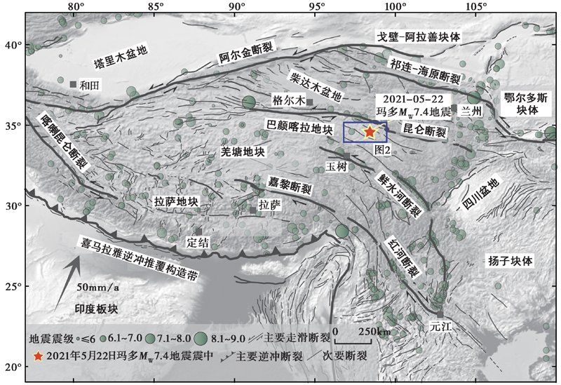
Fig. 1 Distribution of major active faults and earthquakes of the Tibetan plateau.
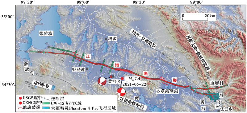
Fig. 2 Map showing the UAV operation area.
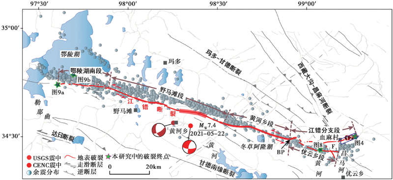
Fig. 3 Segmentation of coseismic surface rupture of the Madoi MW7.4 earthquake and distribution of active faults in the study area.
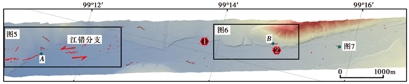
Fig. 4 High-resolution DEM and mapping of the surface ruptures along the Jiangcuo section.
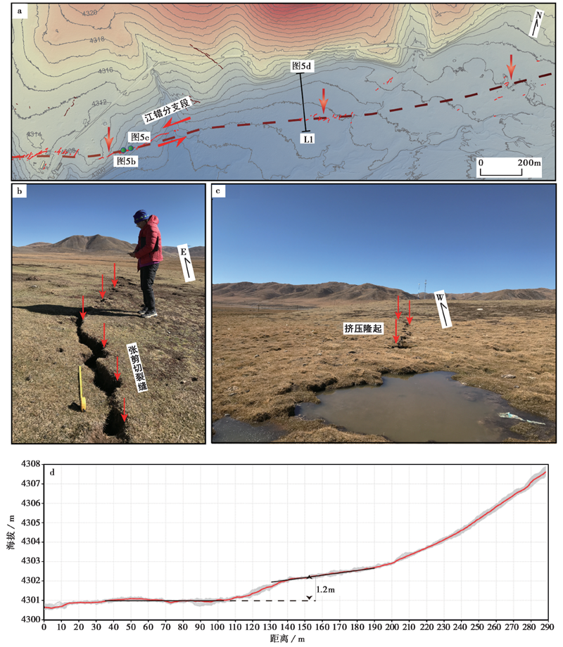
Fig. 5 Characteristics of the coseismic surface ruptures near the Xuema village.
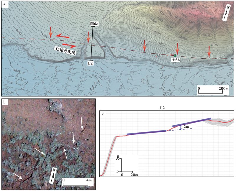
Fig. 6 Sparse distribution of the coseismic surface ruptures to the east of the Xuema village produced by Madoi earthquake.
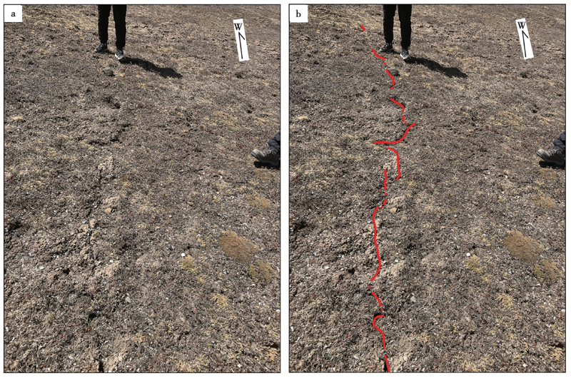
Fig. 7 Characteristics of the subtle coseismic surface ruptures to the eastern end of the Jiangcuo section.
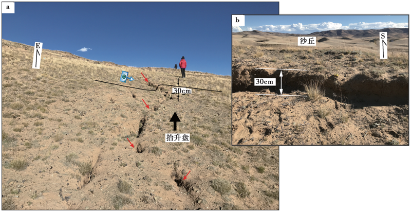
Fig. 8 Photographs showing coseismic surface ruptures in the dune of the Youyunxiang section.
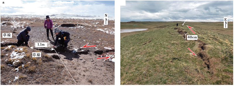
Fig. 9 Characteristics of coseismic surface ruptures of the Eling Lake section.
| 序号 | 地表破裂长度/km | 量测方法 | 来源 |
|---|---|---|---|
| 1 | 152.4 | 野外踏勘 | 潘佳伟等, 2021 |
| 2 | 160 | 野外踏勘 | 李智敏等, |
| 3 | 170 | 大地测量 | 王未来等, |
| 4 | 150 | 大地测量 | 赵韬等, |
| 5 | 180 | 大地测量 | 徐志国等, |
| 6 | 210 | 大地测量 | 华俊等, |
Table1 Length of the coseismic surface ruptures of the MW7.4 Madoi earthquake
| 序号 | 地表破裂长度/km | 量测方法 | 来源 |
|---|---|---|---|
| 1 | 152.4 | 野外踏勘 | 潘佳伟等, 2021 |
| 2 | 160 | 野外踏勘 | 李智敏等, |
| 3 | 170 | 大地测量 | 王未来等, |
| 4 | 150 | 大地测量 | 赵韬等, |
| 5 | 180 | 大地测量 | 徐志国等, |
| 6 | 210 | 大地测量 | 华俊等, |
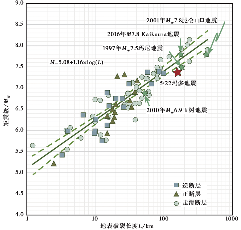
Fig. 10 Regressions of moment magnitude versus surface rupture length(modified based on results of Well et al.,1994).
| [1] | 程丰, 李德威, Jerry B, 等. 2012. 玉树地震地表破裂特征及其破裂方式[J]. 大地构造与成矿学, 36(1): 69-75. |
| CHENG Feng, LI De-wei, Jerry B,et al. 2012. Characteristics and patterns of surface ruptures caused by the Yushu earthquake[J]. Geotectonica et Metallogenia, 36(1): 69-75. (in Chinese) | |
| [2] | 戴华光. 1983. 1947年青海达日$7\frac{3}{4}$级地震[J]. 西北地震学报, 5(3): 71-77. |
| DAI Hua-guang. 1983. On the Dari earthquake of 1947 in Qinghai Province[J]. Northwestern Seismological Journal, 5(3): 71-77. (in Chinese) | |
| [3] | 邓起东, 高翔, 陈桂华, 等. 2010. 青藏高原昆仑-汶川地震系列与巴颜喀喇断块的最新活动[J]. 地学前缘, 17(5): 163-178. |
| DENG Qi-dong, GAO Xiang, CHEN Gui-hua,et al. 2010. Recent tectonic activity of Bayankala fault-block and the Kunlun-Wenchuan earthquake series of the Tibetan plateau[J]. Earth Science Frontiers, 17(5): 163-178. (in Chinese) | |
| [4] | 国家地震局阿尔金活动断裂带课题组. 1992. 阿尔金活动断裂带[M]. 北京: 地震出版社: 1-319. |
| Research Group on Active Altun Fault Zone of State Seismological Bureau. 1992. The Altun Active Fault Zone[M]. Seismological Press, Beijing: 1-319. (in Chinese) | |
| [5] | 国家地震局震害防御司. 1995. 中国历史强震目录 [Z]. 北京: 地震出版社: 1-514. |
| Department of Earthquake Disaster Prevention of State Seismological Bureau. 1995. The Catalogue of Historical Strong Earthquakes of China [Z]. Seismological Press, Beijing: 1-514. (in Chinese) | |
| [6] |
华俊, 赵德政, 单新建, 等. 2021. 2021年青海玛多 MW7.3 地震InSAR的同震形变场、 断层滑动分布及其对周边区域的应力扰动[J]. 地震地质, 43(3): 677-691. doi: 10.3969/j.issn.0253-4567.2021.03.013.
DOI |
| HUA Jun, ZHAO De-zheng, SHAN Xin-jian,et al. 2021. Coseismic deformation field, slip distribution and Coulomb stress disturbance of the 2021 MW7.3 Maduo earthquake using Sentinel-1 InSAR observations[J]. Seismology and Geology, 43(3): 677-691. (in Chinese) | |
| [7] |
李智敏, 李文巧, 李涛, 等. 2021. 2021年5月22日青海玛多 MS7.4 地震的发震构造和地表破裂初步调查[J]. 地震地质, 43(3): 722-737. doi: 10.3969/j.issn.0253-4967.2021.03.016.
DOI |
| LI Zhi-min, LI Wen-qiao, LI Tao,et al. 2021. Seismogenic fault and coseismic surface deformation of the Maduo MS7.4 earthquake in Qinghai, China: A quick report[J]. Seismology and Geology, 43(3): 722-737. (in Chinese) | |
| [8] |
梁明剑, 杨耀, 杜方, 等. 2020. 青海达日断裂中段晚第四纪活动性与1947年$M7\frac{3}{4}$地震地表破裂带再研究[J]. 地震地质, 42(3): 703-714. doi: 10.3969/j.issn.0253-4967.2020.03.011.
DOI |
| LIANG Ming-jian, YANG Yao, DU Fang,et al. 2020. Late Quaternary activity of the central segment of the Dari Fault and restudy of the surface rupture zone of the 1947 $M7\frac{3}{4}$Dari earthquake, Qinghai Province[J]. Seismology and Geology, 42(3): 703-714. (in Chinese) | |
| [9] |
梁明剑, 周荣军, 闫亮, 等. 2014. 青海达日断裂中段构造活动与地貌发育的响应关系探讨[J]. 地震地质, 36(1): 28-38. doi: 10.3969/j.issn.0253-4967.2014.02.003.
DOI |
| LIANG Ming-jian, ZHOU Rong-jun, YAN Liang,et al. 2014. The relationships between neotectonic activity of the middle segment of Dari Fault and its geomorphological response, Qinghai Province, China[J]. Seismology and Geology, 36(1): 28-38. (in Chinese) | |
| [10] | 潘家伟, 白明坤, 李超, 等. 2021. 2021年5月22日青海玛多 MS7.4 地震地表破裂带及发震构造[J]. 地质学报, 95(6): 1655-1670. |
| PAN Jia-wei, BAI Ming-kun, LI Chao,et al. 2021. Coseismic surface rupture and seismogenic structure of the 2021-05-22 Maduo(Qinghai) MS7.4 earthquake[J]. Acta Geologica Sinica, 95(6): 1655-1670. (in Chinese) | |
| [11] | 青海省地震局, 中国地震局地壳应力研究所. 1999. 东昆仑活动断裂带[M]. 北京: 地震出版社: 1-227. |
| Seismological Bureau of Qinghai Province,Institute of Crustal Dynamics, China Earthquake Administration. 1999. The Eastern Kunlun Active Fault Zone[M]. Seismological Press, Beijing: 1-227. (in Chinese) | |
| [12] | 孙鑫喆, 徐锡伟, 陈立春, 等. 2012. 2010年玉树地震地表破裂带典型破裂样式及其构造意义[J]. 地球物理学报, 55(1): 155-170. |
| SUN Xin-zhe, XU Xi-wei, CHEN Li-chun,et al. 2010. Surface rupture features of the 2010 Yushu earthquake and its tectonic implication[J]. Chinese Journal of Geophysics, 55(1): 155-170. (in Chinese) | |
| [13] | 王未来, 房立华, 吴建平, 等. 2021. 2021年青海玛多 MS7.4 地震序列精定位研究[J]. 中国科学(D辑), 51(7): 1193-1202. |
| WANG Wei-lai, FANG Li-hua, WU Jian-ping,et al. 2021. Aftershock sequence relocation of the 2021 MS7.4 Maduo earthquake, Qinghai, China[J]. Science China Earth Sciences, 51(7): 1193-1202. (in Chinese) | |
| [14] | 闻学泽. 2018. 巴颜喀拉块体东边界千年破裂历史与2008年汶川、 2013年芦山和2017年九寨沟地震[J]. 地震学报, 40(3): 255-267. |
| WEN Xue-ze. 2018. The 2008 Wenchuan, 2013 Lushan and 2017 Jiuzhaigou earthquakes, Sichuan, in the last more than one thousand years of rupture history of the eastern margin of the Bayan Har block[J]. Acta Seismologica Sinica, 40(3): 255-267. (in Chinese) | |
| [15] | 徐锡伟, 陈文彬, 于贵华, 等. 2002. 2001年11月14日昆仑山库赛湖地震( MS8.1 )地表破裂带的基本特征[J]. 地震地质, 24(1): 1-13, 133-136. |
| XU Xi-wei, CHEN Wen-bin, YU Gui-hua,et al. 2002. Characteristic features of the surface ruptures of the Hoh Sai Hu(Kunlunshan)earthquake( MS8.1 ), northern Tibetan plateau, China[J]. Seismology and Geology, 24(1): 1-13, 133-136. (in Chinese) | |
| [16] | 徐志国, 梁姗姗, 张广伟, 等. 2021. 2021年5月22日青海玛多 MS7.4 地震发震构造分析[J]. 地球物理学报, 64(8): 2657-2670. |
| XU Zhi-guo, LIANG Shan-shan, ZHANG Guang-wei,et al. 2021. Analysis of seismogenic structure of Madoi, Qinghai MS7.4 earthquake on May 22, 2021[J]. Chinese Journal of Geophysics, 64(8): 2657-2670. (in Chinese) | |
| [17] | 袁兆德, 刘静, 周游, 等. 2019. 阿尔金断裂中段乌尊硝尔段古地震记录与级联破裂行为[J]. 中国科学(D辑), 50(1): 50-65. |
| YUAN Zhao-de, LIU-ZENG Jing, ZHOU You,et al. 2019. Paleoseismologic record of earthquakes along the Wuzunxiaoer section of the Altyn Tagh Fault and its implication for cascade rupture behavior[J]. Science in China(Ser D), 50(1): 50-65. (in Chinese) | |
| [18] | 张军龙, 任金卫, 陈长云, 等. 2014. 东昆仑断裂带东部晚更新世以来活动特征及其大地构造意义[J]. 中国科学(D辑), 44(4): 654-667. |
| ZHANG Jun-long, REN Jin-wei, CHEN Chang-yun,et al. 2014. The Late Pleistocene activity of the eastern part of east Kunlun fault zone and its tectonic significance[J]. Science in China(Ser D), 44(4): 654-667. (in Chinese) | |
| [19] | 张培震, 邓起东, 张国民, 等. 2003. 中国大陆的强震活动与活动地块[J]. 中国科学(D辑), 33(S1): 12-20. |
| ZHANG Pei-zhen, DENG Qi-dong, ZHANG Guo-min,et al. 2003. Active tectonic blocks and strong earthquake in the continent of China[J]. Science in China(Ser D), 33(S1): 12-20. (in Chinese) | |
| [20] | 张培震, 徐锡伟, 闻学泽, 等. 2008. 2008年汶川8.0级地震发震断裂的滑动速率、 复发周期和构造成因[J]. 地球物理学报, 51(4): 1066-1073. |
| ZHANG Pei-zhen, XU Xi-wei, WEN Xu-ze,et al. 2008. Slip rates and recurrence intervals of the Longmen Shan active fault zone and tectonic implications for the mechanism of the May 12 Wenchuan earthquake, 2008, Sichuan, China[J]. Chinese Journal of Geophysics, 51(4): 1066-1073. (in Chinese) | |
| [21] | 赵韬, 王莹, 马冀, 等. 2021. 2021年青海玛多7.4级地震序列重定位和震源机制特征[J]. 地震地质, 43(4): 790-805. |
| ZHAO Tao, WANG Ying, MA Ji,et al. 2021. Relocation and focal mechanism solutions of the 2021 Maduo, Qinghai MS7.4 earthquake sequence[J]. Seismology and Geology, 43(4): 790-805. (in Chinese) | |
| [22] | 中国地震局震害防御司. 1999. Seismology and Geology[z]. 北京, 中国科技出版社: 1-637. |
| Department of Earthquake Disaster Prevention of State Seismological Bureau. 1999. The Catalogue of Modern Earthquakes of China(1912-1990AD, MS≥4.7)[Z]. Science and Technology Press: Beijing: 1-637. (in Chinese) | |
| [23] |
Burchfiel B C, Chen Z L, Liu Y P,et al. 1995. Tectonics of the Longmen Shan and adjacent regions, central China[J]. International Geology Review, 37(8): 661-735.
DOI URL |
| [24] | Bonilla M G, Mark R K, Lienkaemper J J. 1984. Statistical relations among earthquake magnitude, surface rupture length, and surface fault displacement[J]. Bulletin of the Seismological Society of America, 74(6): 2379-2411. |
| [25] | Chen K, Avouac J P, Geng J,et al. 2022. The 2021 MW7.4 Madoi earthquake: An archetype bilateral slip-pulse rupture arrested at a splay fault[J]. Geophysical Research Letters, 49(2): 1-9. |
| [26] |
Dietz L D, Ellsworth W L. 1990. The October 17, 1989, Loma Prieta, California, earthquake and its aftershocks: Geometry of the sequence from high-resolution locations[J]. Geophysical Research Letters, 17(9): 1417-1420.
DOI URL |
| [27] | Dietz L D, Ellsworth W L. 1997. Aftershocks of the Loma Prieta earthquake and their tectonic implications[J]. USGS Professional Paper: 1550( 4): D5-D47. |
| [28] | Fisher R, Dawson-Howe K, Fitzgibbon A,et al. 2005. Dictionary of Computer Vision and Image Processing[M]. John Wiley & Sons: Hoboken. |
| [29] |
Fonstad M A, Dietrich J T, Courville B C,et al. 2013. Topographic structure from motion: A new development in photogrammetric measurement[J]. Earth Surface Processes and Landforms, 38(4): 421-430.
DOI URL |
| [30] | He L, Feng G, Wu X,et al. 2021. Coseismic and early postseismic slip models of the 2021 MW7.4 Maduo earthquake(western China)estimated by space-based geodetic data[J]. Geophysical Research Letters, 48(24): 1-10. |
| [31] |
Hudnut K W, Brooks B A, Scharer K,et al. 2020. Airborne Lidar and electro-optical imagery along surface ruptures of the 2019 Ridgecrest earthquake sequence, southern California[J]. Seismological Research Letters, 91(4): 2096-2107.
DOI URL |
| [32] |
Klinger Y, Xu X W, Tapponnier P,et al. 2005. High-resolution satellite imagery mapping of the surface rupture and slip distribution of the MW7.8, 14 November 2001 Kokoxili earthquake, Kunlun Fault, northern Tibet, China[J]. Bulletin of the Seismological Society of America, 95(5): 1970-1987.
DOI URL |
| [33] | Kanamori H, Anderson D L. 1975. Theoretical basis of some empirical relations in seismology[J]. Bulletin of the Seismological Society of America, 65(5): 1073-1095. |
| [34] | Jin Z, Fialko Y. 2021. Coseismic and early postseismic deformation due to the 2021 M7.4 Maduo(China)earthquake[J]. Geophysical Research Letters, 48(21): 1-10. |
| [35] |
Johnson K, Nissen E, Saripalli S,et al. 2014. Rapid mapping of ultrafine fault zone topography with structure from motion[J]. Geosphere, 10(5): 969-986.
DOI URL |
| [36] |
Li C, Pang J, Zhang Z. 2012. Characteristics, geometry, and segmentation of the surface rupture associated with the 14 April 2010 Yushu earthquake, eastern Tibet, China[J]. Bulletin of the Seismological Society of America, 102(4): 1618-1638.
DOI URL |
| [37] | Molnar P, Stock J M. 2009. Slowing of India's convergence with Eurasia since 20Ma and its implications for Tibetan mantle dynamics[J]. Tectonics, 28(3): 1-11. |
| [38] |
Oskin M E, Arrowsmith J R, Corona A H,et al. 2012. Near-field deformation from the El Mayor-Cucapah earthquake revealed by differential LiDAR[J]. Science, 335(6069): 702-705.
DOI URL |
| [39] |
Tapponnier P, Peltzer G, Le Dain A Y,et al. 1982. Propagating extrusion tectonics in Asia: New insights from simple experiments with plasticine[J]. Geology, 10(12): 611-616.
DOI URL |
| [40] |
Tapponnier P, Xu Z Q, Roger F,et al. 2001. Oblique stepwise rise and growth of the Tibet Plateau[J]. Science, 294(5547): 1671-1677.
PMID |
| [41] |
Ren Z K, Zhang Z Q. 2019. Structural analysis of the 1997 MW7.5 Manyi earthquake and the kinematics of the Manyi Fault, central Tibetan plateau[J]. Journal of Asian Earth Sciences, 179: 149-164.
DOI URL |
| [42] |
Stirling M, Gerstenberger M, Litchfield N,et al. 2008. Seismic hazard of the Canterbury region, New Zealand: New earthquake source model and methodology[J]. Bulletin of the New Zealand Society for Earthquake Engineering, 41(2): 51-67.
DOI URL |
| [43] |
van der Woerd J, Tapponnier P, Ryerson F J,et al. 2002. Uniform postglacial slip-rate along the central 600km of the Kunlun Fault(Tibet), from 26Al, 10Be, and 14C dating of riser offsets, and climatic origin of the regional morphology[J]. Geophysical Journal International, 148(3): 356-388.
DOI URL |
| [44] | Wells D L, Coppersmith K J. 1994. New empirical relationships among magnitude, rupture length, rupture width, rupture area, and surface displacement[J]. Bulletin of the Seismological Society of America, 84(4): 974-1002. |
| [45] |
Wen X Z, Ma S L, Xu X W,et al. 2008. Historical pattern and behavior of earthquake ruptures along the eastern boundary of the Sichuan-Yunnan faulted-block, southwestern China[J]. Physics of the Earth and Planetary Interiors, 168(1-2): 16-36.
DOI URL |
| [46] |
Wesnousky S G. 2008. Displacement and geometrical characteristics of earthquake surface ruptures: Issues and implications for seismic-hazard analysis and the process of earthquake rupture[J]. Bulletin of the Seismological Society of America, 98(4): 1609-1632.
DOI URL |
| [47] |
Westoby M J, Brasington J, Glasser N F,et al. 2012. Structure-from-Motion photogrammetry: A low cost, effective tool for geoscience applications[J]. Geomorphology, 179: 300-314.
DOI URL |
| [48] | Xu X, Yu G, Klinger Y,et al. 2006. Reevaluation of surface rupture parameters and faulting segmentation of the 2001 Kunlunshan earthquake( MW7.8 ), northern Tibetan plateau, China[J]. Journal of Geophysical Research, 111(B5): 1-16. |
| [49] | Zhao D, Qu C, Chen H,et al. 2021. Tectonic and geometric control on fault kinematics of the 2021 MW7.3 Maduo(China)earthquake inferred from interseismic, coseismic, and postseismic InSAR observations[J]. Geophysical Research Letters, 48(18): 1-12. |
| [1] | DENG Wen-ze, LIU Jie, YANG Zhi-gao, SUN Li, ZHANG Xue-mei. PRELIMINARY ANALYSIS FOR RUPTURE PROCESS OF THE MAY 22TH, 2021, MADOI(QINGHAI) MS7.4 EARTHQUAKE [J]. SEISMOLOGY AND GEOLOGY, 2022, 44(4): 1059-1070. |
| [2] | SHAO Yan-xiu, LIU-ZENG Jing, GAO Yun-peng, WANG Wen-xin, YAO Wen-qian, HAN Long-fei, LIU Zhi-jun, ZOU Xiao-bo, WANG Yan, LI Yun-shuai, LIU Lu. COSEISMIC DISPLACEMENT MEASUREMENT AND DISTRIBUTED DEFORMATION CHARACTERIZATION: A CASE OF 2021 MW7.4 MADOI EARTHQUAKE [J]. SEISMOLOGY AND GEOLOGY, 2022, 44(2): 506-523. |
| [3] | HAN Long-fei, LIU-ZENG Jing, YAO Wen-qian, WANG Wen-xin, LIU Xiao-li, GAO Yun-peng, SHAO Yan-xiu, LI Jin-yang. DETAILED MAPPING OF THE SURFACE RUPTURE NEAR THE EPICENTER SEGMENT OF THE 2021 MADOI MW7.4 EARTHQUAKE AND DISCUSSION ON DISTRIBUTED RUPTURE IN THE STEP-OVER [J]. SEISMOLOGY AND GEOLOGY, 2022, 44(2): 484-505. |
| [4] | LIU Xiao-li, XIA Tao, LIU-ZENG Jing, YAO Wen-qian, XU Jing, DENG De-bei-er, HAN Long-fei, JIA Zhi-ge, SHAO Yan-xiu, WANG Yan, YUE Zi-yang, GAO Tian-qi. DISTRIBUTED CHARACTERISTICS OF THE SURFACE DEFORMATIONS ASSOCIATED WITH THE 2021 MW7.4 MADOI EARTHQUAKE, QINGHAI, CHINA [J]. SEISMOLOGY AND GEOLOGY, 2022, 44(2): 461-483. |
| Viewed | ||||||
|
Full text |
|
|||||
|
Abstract |
|
|||||
