SEISMOLOGY AND GEOLOGY ›› 2022, Vol. 44 ›› Issue (3): 686-700.DOI: 10.3969/j.issn.0253-4967.2022.03.008
• Special topic on extremely low-frequency seismo-electromagnetic phenomena • Previous Articles Next Articles
ZHAO Ling-qiang1,2,3)( ), ZHAN Yan1,2),*(), WANG Qing-liang3), SUN Xiang-yu1,2), HAN Jing1,2), CAO Cong3), ZHANG Song3), CAI Yan4)
Received:2021-05-12
Revised:2021-08-08
Online:2022-06-20
Published:2022-08-02
Contact:
ZHAN Yan
赵凌强1,2,3)(), 詹艳1,2),*(), 王庆良3), 孙翔宇1,2), 韩静1,2), 操聪3), 张松3), 蔡妍4)
通讯作者:
詹艳
作者简介:赵凌强, 男, 1988年生, 2020年于中国地震局地质研究所获固体地球物理学专业博士学位, 高级工程师, 研究方向为大地电磁数据处理与解释, E-mail: zhaolingqiang0926@126.com。
基金资助:CLC Number:
ZHAO Ling-qiang, ZHAN Yan, WANG Qing-liang, SUN Xiang-yu, HAN Jing, CAO Cong, ZHANG Song, CAI Yan. THE SEISMOGENIC STRUCTURE OF THE 1303 HONGTONG M8 EARTHQUAKE INFERRED FROM MAGNETOTELLURIC IMAGING[J]. SEISMOLOGY AND GEOLOGY, 2022, 44(3): 686-700.
赵凌强, 詹艳, 王庆良, 孙翔宇, 韩静, 操聪, 张松, 蔡妍. 大地电磁数据揭示的1303年洪洞8级地震区精细结构[J]. 地震地质, 2022, 44(3): 686-700.
Add to citation manager EndNote|Ris|BibTeX
URL: https://www.dzdz.ac.cn/EN/10.3969/j.issn.0253-4967.2022.03.008
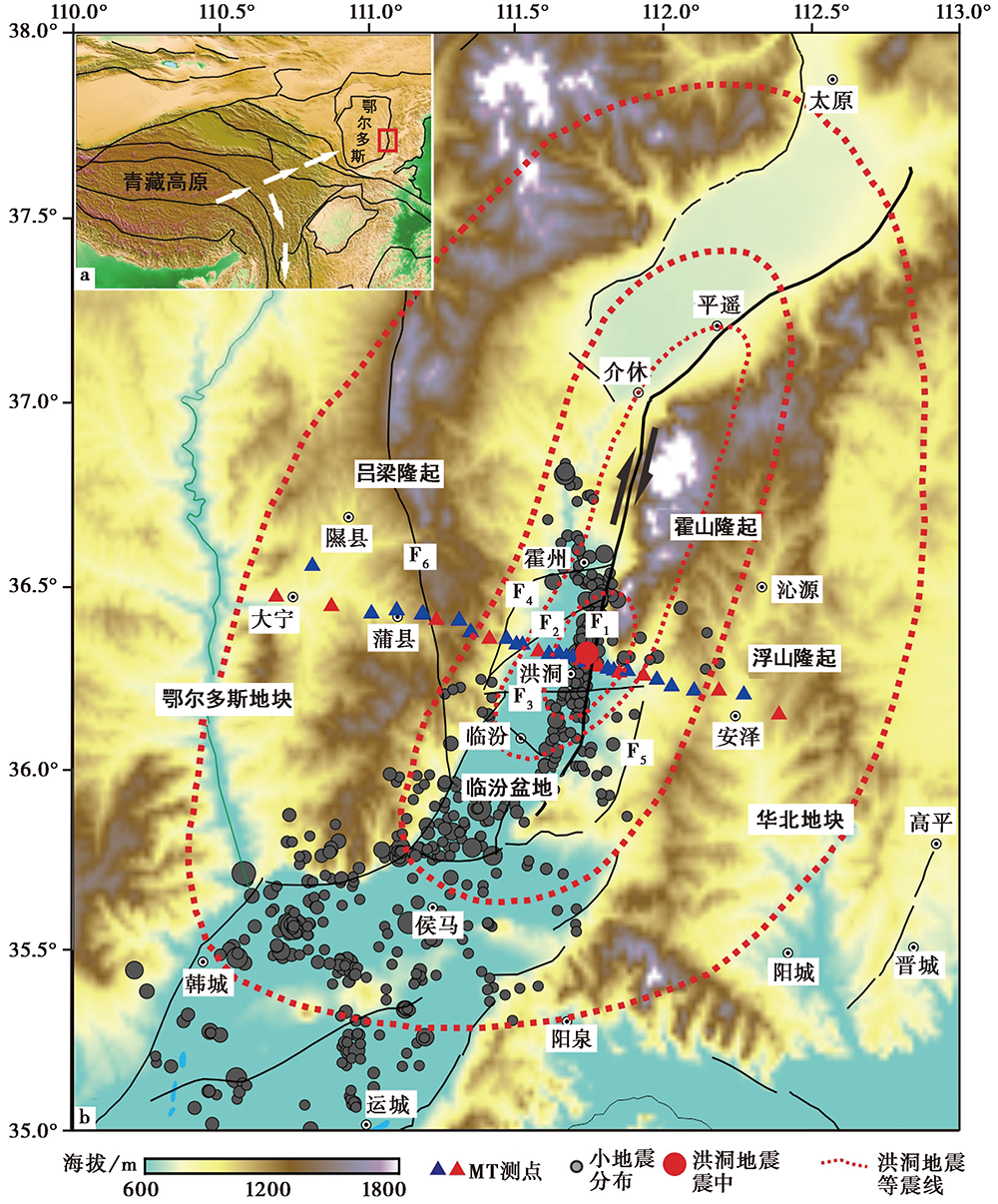
Fig. 1 The tectonic outline map(a), the faults and magnetotelluric measurement sites of the study area(b).
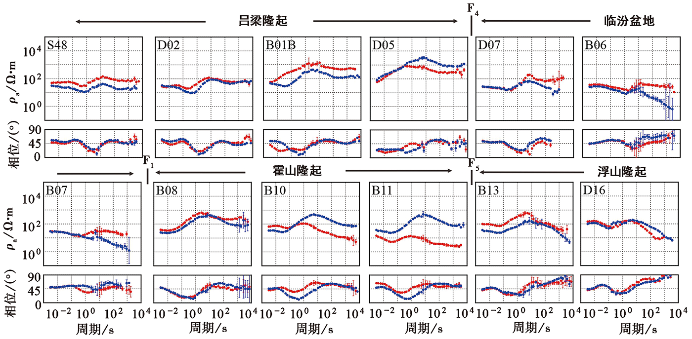
Fig. 2 Apparent resistivity and impedance phase curves of typical measuring points along profile.
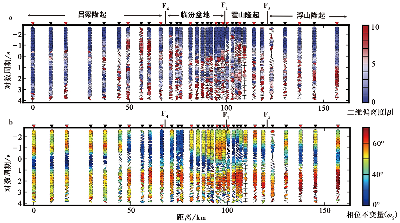
Fig. 3 The |β| phase tensor ellipse (a) and phase-tensor (b) of different periods along profile.
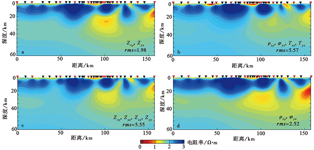
Fig. 4 Different input parameters of 3D result along the profile.

Fig. 5 Deep electric structure and interpretation of the profile.
| [1] | 蔡军涛, 陈小斌, 赵国泽. 2010. 大地电磁资料精细处理和二维反演解释技术研究(一): 阻抗张量分解与构造维性分析[J]. 地球物理学报, 53(10): 2516—2526. |
| CAI Jun-tao, CHEN Xiao-bin, ZHAO Guo-ze. 2010. Refined techniques for data processing and two-dimensional inversion in magnetotelluricⅠ: Tensor decomposition and dimensionality analysis[J]. Chinese Journal of Geophysics, 53(10): 2516—2526 (in Chinese). | |
| [2] | 陈小斌, 臧绍先, 魏荣强. 2011. 稳定的鄂尔多斯地块在整体运动吗?[J]地球物理学报, 54(7): 1750—1757. |
| CHEN Xiao-bin, ZANG Shao-xian, WEI Rong-qiang. 2011. Is the stable Ordos block migrating as an entire block?[J]. Chinese Journal of Geophysics, 54(7): 1750—1757 (in Chinese). | |
| [3] | 陈小斌, 赵国泽, 詹艳. 2004. MT资料处理与解释的Windows可视化集成系统[J]. 石油地球物理勘探, 39(S1): 11—16. |
| CHEN Xiao-bin, ZHAO Guo-ze, ZHAN Yan. 2004. A visual integrated windows system for MT data processing and interpretation[J]. Oil Geophysical Prospecting, 39(S1): 11—16 (in Chinese). | |
| [4] | 陈兆辉, 王椿镛, 楼海. 2018. 鄂尔多斯地块地壳上地幔速度结构及构造意义[J]. 科学通报, 63(3): 327—339. |
| CHEN Zhao-hui, WANG Chun-yong, LOU Hai. 2018. Crust and upper mantle velocity structure beneath the Ordos Block and its tectonic significance[J]. Chinese Science Bulletin, 63(3): 327—339 (in Chinese). | |
| [5] | 邓起东, 张培震, 冉勇康, 等. 2003. 中国活动构造与地震活动[J]. 地学前缘, 10(S1): 66—73. |
| DENG Qi-dong, ZHANG Pei-zhen, RAN Yong-kang, et al. 2003. Active tectonics and earthquake activities in China[J]. Earth Science Frontiers, 10(S1): 66—73 (in Chinese). | |
| [6] | 高孟潭, 金学申, 安卫平, 等. 2004. 1303年洪洞8级地震GIS 系统与震害分布特征分析[J]. 地震学报, 26(4): 363—368. |
| GAO Meng-tan, JIN Xue-shen, AN Wei-ping, et al. 2004. The GIS and analysis of earthquake damage distribution of the 1303 Hongdong M=8 earthquake[J]. Acta Seismologica Sinica, 26(4): 363—368 (in Chinese). | |
| [7] | 国家地震局“鄂尔多斯周缘活动断裂系”课题组. 1988. 鄂尔多斯周缘活动断裂系[M]. 北京: 地震出版社. |
| The Research Group on “Active Fault System around Orods Massif”, State Seismological Bureau. 1988. Active Fault System around Massif[M]. Seismological Press, Beijing (in Chinese). | |
| [8] | 胡新亮, 刁桂苓, 高景春, 等. 2002. 用现今小震推断洪洞、 临汾2次历史大震的震源断层[J]. 中国地震, 18(1): 76—85. |
| HU Xin-liang, DIAO Gui-ling, GAO Jing-chun, et al. 2002. Application of present small earthquakes to infer the focal faults of two large historical earthquakes in Hongdong and Linfen, Shanxi Province[J]. Earthquake Research in China, 18(1): 76—85 (in Chinese). | |
| [9] | 李晨晶, 白登海, 薛帅, 等. 2017. 鄂尔多斯地块深部岩石圈电性结构研究[J]. 地球物理学报, 60(5): 1788—1799. |
| LI Chen-jing, BAI Deng-hai, XUE Shuai, et al. 2017. A magnitotelluric study of the deep electric structure beneath the Ordos Block[J]. Chinese Journal Geophysics, 60(5): 1788—1799 (in Chinese). | |
| [10] | 李自红, 刘保金, 袁洪克, 等. 2014. 临汾盆地地壳精细结构和构造: 地震反射剖面结果[J]. 地球物理学报, 57(5): 1487—1497. |
| LI Zi-hong, LIU Bao-jin, YUAN Hong-ke, et al. 2014. Fine crustal structure and tectonics of Linfen Basin from the results of seismic reflect profile[J]. Chinese Journal of Geophysics, 57(5): 1487—1497 (in Chinese). | |
| [11] | 刘钟尹, 陈小斌, 蔡军涛. 2017. toPeak: 一个大地电磁三维反演的可视化客户端软件[C]. 第十三届中国国际地球物理学术讨论会. |
| LIU Zhong-yin, CHEN Xiao-bin, CAI Jun-tao. 2017. toPeak: A visual client software for magnetotelluric three-dimensional inversion[C]//13th China International Geophysical Symposium (in Chinese). | |
| [12] | 江娃利, 邓起东, 徐锡伟, 等. 2004. 1303年山西洪洞8级地震地表破裂带[J]. 地震学报, 26(4): 355—362. |
| JIANG Wa-li, DENG Qi-dong, XU Xi-wei, et al. 2004. Structure rupture zone of the 1303 Hongdong M=8 earthquake, Shanxi Province[J]. Acta Seismologica Sinica, 26(4): 355—362 (in Chinese). | |
| [13] | 孟宪梁, 于慎谔, 奚云. 1985. 山西洪洞8级地震形变遗迹研究[J]. 地震地质, 7(4): 1—10. |
| MENG Xian-liang, YU Shen-e, XI Yun. 1985. The investigations of deformation traces of MS=8.0 earthquake in Hongdong, Shanxi Province[J]. Seismology and Geology, 7(4): 1—10 (in Chinese). | |
| [14] |
孙翔宇, 詹艳, 赵凌强, 等. 2020. 东昆仑断裂带东端和2017年九寨沟7.0级地震区深部电性结构探测[J]. 地震地质, 42(1): 182—197. doi: 10.3969/j.issn.0253-4967.2020.01.012.
DOI |
| SUN Xiang-yu, ZHAN Yan, ZHAO Ling-qiang, et al. 2020. Electrical structure of the 2017 MS7.0 Jiuzhaigou earthquake region and the eastern terminus of the east Kunlun Fault[J]. Seismology and Geology, 42(1): 182—197 (in Chinese). | |
| [15] | 汤吉, 詹艳, 赵国泽, 等. 2005. 青藏高原东北缘玛沁—兰州—靖边剖面地壳上地幔电性结构研究[J]. 地球物理学报, 48(5): 1205—1216. |
| TANG Ji, ZHAN Yan, ZHAO Guo-ze, et al. 2005. Electrical structure of crust and upper mantle in Maqin-Lanzhou-Jingbian section, northeastern margin of Qinghai-Tibet Plateau[J]. Chinese Journal of Geophysics, 48(5): 1205—1216. | |
| [16] | 王鑫, 詹艳, 赵国泽, 等. 2010. 鄂尔多斯断块西缘构造带北段深部电性结构[J]. 地球物理学报, 50(3): 595—604. |
| WANG Xin, ZHAN Yan, ZHAO Guo-ze, et al. 2010. Deep electric structure beneath the northern section of the western margin of the Ordos Basin[J]. Chinese Journal of Geophysics, 50(3): 595—604 (in Chinese). | |
| [17] |
翁爱华, 李建平, 范小平, 等. 2018. 大地电磁测深揭示的1668 年郯城8.5级地震震中地壳精细结构[J]. 地震地质, 40(2): 396—409. doi: 10.3969/j.issn.0253-4967.2018.02.008.
DOI |
| WENG Ai-hua, LI Jian-ping, FAN Xiao-ping, et al. 2018. Fine electrical structure beneath the epicenter of 1668 Tancheng MS8.5 earthquake revealed by MT sounding[J]. Seismology and Geology, 40(2): 396—409 (in Chinese). | |
| [18] | 谢新生, 江娃利, 王焕贞, 等. 2004. 山西太谷断裂带全新世活动及其与1303年洪洞8级地震的关系[J]. 地震学报, 26(3): 281—293. |
| XIE Xin-sheng, JIANG Wa-li, WANG Huan-zhen, et al. 2004. Holocene activities of the Taigu fault zone, Shanxi Province, in relation to the 1303 Hongdong M=8 earthquake[J]. Acta Seismologica Sinica, 26(3): 281—293 (in Chinese). | |
| [19] | 许林斌, 魏文博, 金胜, 等. 2017. 鄂尔多斯地块北部至阴山造山带深部电性结构特征研究[J]. 地球物理学报, 60(2): 575—584. |
| XU Lin-bin, WEI Wen-bo, JIN Sheng, et al. 2017. Study of deep electrical structure along a profile from northern Ordos block to Yinshan orogenic belt[J]. Chinese Journal of Geophysics, 60(2): 575—584 (in Chinese). | |
| [20] | 徐锡伟, 邓起东. 1990. 山西霍山山前断裂晚第四纪活动特征和1303年洪洞8级地震[J]. 地震地质, 12(1): 21—30. |
| XU Xi-wei, DENG Qi-dong. 1990. The features of Late Quaternary activity of the piedmont fault of Mt Huoshan Shanxi Province and 1303 Hongdong earthquake(MS=8)[J]. Seismology and Geology, 12(1): 21—30 (in Chinese). | |
| [21] | 徐岳仁. 2012. 山西霍山山前断裂带晚第四纪活动特征研究[D]. 北京: 中国地震局地质研究所. |
| XU Yue-ren. 2012. A study on the late Quaternary faulting of the Huoshan piedmont fault zone in the central Shanxi faulted basin belt[D]. Institute of Geology, China Earthquake Administration, Beijing (in Chinese). | |
| [22] | 詹艳, 赵国泽, Unsworth M, 等. 2013. 龙门山断裂带西南段4.20芦山7.0级地震区的深部结构和孕震环境[J]. 科学通报, 58(20): 1917—1924. |
| ZHAN Yan, ZHAO Guo-ze, Unsworth M, et al. 2013. Deep structure beneath the southwestern section of the Longmenshan fault zone and seismogenetic context of the 4·20 MS7.0 earthquake[J]. Chinese Science Bulletin, 58(20): 1917—1924 (in Chinese). | |
| [23] | 詹艳, 赵国泽, 王继军, 等. 2008. 1927年古浪8级大震区及其周边地块的深部电性结构[J]. 地球物理学报, 51(2): 220—229. |
| ZHAN Yan, ZHAO Guo-ze, WANG Ji-jun, et al. 2008. Deep electric structure beneath the epicenter of the 1927 Gulang M8 earthquake and its adjacent areas from magnetotelluric sounding[J]. Chinese Journal of Geophysics, 51(2): 220—229 (in Chinese). | |
| [24] | 赵国泽, 詹艳, 王立凤, 等. 2010. 鄂尔多斯断块地壳电性结构[J]. 地震地质, 32(3): 345—359. |
| ZHAO Guo-ze, ZHAN Yan, WANG Li-feng, et al. 2010. Electric structure of the crust beneath the Ordos fault block[J]. Seismology and Geology, 32(3): 345—359 (in Chinese). | |
| [25] |
赵凌强, 詹艳, 赵国泽, 等. 2015. 基于深部电性结构特征的2013年甘肃岷县漳县 MS6.6 地震孕震环境探讨[J]. 地震地质, 37(2): 541—554. doi: 10.3969/j.issn.0253-4967.2015.02.016.
DOI |
| ZHAO Ling-qiang, ZHAN Yan, ZHAO Guo-ze, et al. 2015. The seismogenic environment of the 2013 Minxian-Zhangxian MS6.6 earthquake based on the deep electrical structure[J]. Seismology and Geology, 37(2): 541—554 (in Chinese). | |
| [26] | 赵凌强, 詹艳, 孙翔宇, 等. 2019. 利用大地电磁技术揭示2016年1月21日青海门源 MS6.4 地震隐伏地震构造和孕震环境[J]. 地球物理学报, 62(6): 2088—2100. |
| ZHAO Ling-qiang, ZHAN Yan, SUN Xiang-yu, et al. 2019. The hidden seismogenic structure and dynamic environment of the 21 January Menyuan, Qinghai, MS6.4 earthquake inferred from magnetotelluric imaging[J]. Chinese Journal of Geophysics, 62(6): 2088—2100 (in Chinese). | |
| [27] | 赵凌强, 詹艳, 王庆良, 等. 2020. 祁连山东端冷龙岭隆起及邻区深部电性结构与孕震构造背景[J]. 地球物理学报, 63(3): 1014—1025. |
| ZHAO Ling-qiang, ZHAN Yan, WANG Qing-liang, et al. 2020. The deep electrical structure and seismogenic background of Lenglongling uplift and its adjacent areas in the eastern end of Qilian Mountains[J]. Chinese Journal of Geophysics, 63(3): 1014—1025 (in Chinese). | |
| [28] |
赵凌强, 詹艳, 周本刚, 等. 2018. 1631年常德历史地震区深部结构的大地电磁探测研究[J]. 地震地质, 40(1): 155—170. doi: 10.3969/j.issn.0253-4967.2018.01.012.
DOI |
| ZHAO Ling-qiang, ZHAN Yan, ZHOU Ben-gang, et al. 2018. Deep structure beneath the 1631 Changde, Hunan M6 earthquake area derived from magnetotelluric sounding[J]. Seismology and Geology, 40(1): 155—170 (in Chinese). | |
| [29] |
Bibby H M, Caldwell T G, Brown C. 2005. Determinable and non-determinable parameters of galvanic distortion in magnetotellurics[J]. Geophysical Journal International, 163(3): 915—930.
DOI URL |
| [30] |
Caldwell T G, Bibbly H M, Brown C. 2004. The magnetotelluric phase tensor[J]. Geophysical Journal International, 158(2): 457—469.
DOI URL |
| [31] |
Chave A D, Thomson D J, Ander M E. 1987. On the robust estimation of power spectra, coherences and transfer functions[J]. Journal of Geophysical Research, 92(B1): 633—648.
DOI URL |
| [32] | Egbert G D, Booker J R. 1986. Robust estimation of geomagnetic transfer functions[J]. Geophysical Research Letters, 87(1): 173—194. |
| [33] |
Egbert G D, Kelbert A. 2012. Computational recipes for electromagnetic inverse problems[J]. Geophysical Journal International, 189(1): 251—267.
DOI URL |
| [34] |
Hao M, Wang Q L, Cui D X, et al. 2016. Present-day crustal vertical motion around the Ordos block constrained by precise leveling and GPS data[J]. Surveys in Geophysics, 37: 923—936.
DOI URL |
| [35] |
Heise W T, Caldwell G, Bibby H M, et al. 2008. Three-dimensional modelling of magnetotelluric data from the Rotokawa geothermal field, Taupo volcanic zone, New Zealand[J]. Geophysical Journal International, 173:740—750.
DOI URL |
| [36] |
Rodi W, Mackie R L. 2001. Nonlinear conjugate gradients algorithm for 2-D magnetotelluric inversion[J]. Geophysics, 66(1): 174—187.
DOI URL |
| [37] | Sun X Y, Zhan Y, Unsworth M, et al. 2020. 3-D magnetotelluric imaging of the easternmost Kunlun Fault: Insights into strain partitioning and the seismotectonics of the Jiuzhaigou MS7.0 earthquake[J]. Journal of Geophysical Research, 125: e2020JB019731. |
| [38] | Sun X Y, Zhan Y, Zhao L Q, et al. 2019. Electrical structure of the Kunlun-Qinling fault system and 2017 M7.0 Jiuzhaigou earthquake inferred from 3-D inversion of magnetotelluric data[J]. Journal of Asian Earth Sciences, 181:10391. |
| [39] |
Xu Y R, He H L, Deng Q D, et al. 2018. The CE 1303 Hongdong earthquake and the Huoshan piedmont fault, Shanxi graben: Implications for magnitude limits of normal fault earthquakes[J]. Journal of Geophysical Research: Solid Earth, 123(4): 3098—3121.
DOI URL |
| [40] |
Zhang H Q, Huang Q H, Zhao G Z, et al. 2016. Three-dimensional conductivity model of crust and uppermost mantle at the northern Trans-North China Orogen: Evidence for a mantle source of Datong volcanoes[J]. Earth and Planetary Science Letters, 453: 182—192.
DOI URL |
| [41] |
Zhang Y G, Zheng W J, Wang Y J, et al. 2018. Contemporary deformation of the North China Plain from global positioning system data[J]. Geophysical Research Letters, 45(4): 1851—1859.
DOI URL |
| [42] |
Zhao G Z, Unsworth M J, Zhan Y, et al. 2012. Crustal structure and rheology of the Longmenshan and Wenchuan MW7.9 earthquake epicentral area from magnetotelluric data[J]. Geology, 40(12): 1139—1142.
DOI URL |
| [1] | ZHAO Ling-qiang, HU Ya-xuan, WANG Qing-liang, ZHU Yi-qing, CAO Cong, LI Zhong-wei, QI Wei, WEN Yu-long. THE CHARACTERISTICS OF DEEP ELECTRICAL STRUCTURE IN LONGGANG VOLCANIC AREA, JILIN PROVINCE [J]. SEISMOLOGY AND GEOLOGY, 2022, 44(4): 845-858. |
| [2] | DONG Ze-yi, TANG Ji, ZHAO Guo-ze, CHEN Xiao-bin, CUI Teng-fa, HAN Bing, JIANG Feng, WANG Li-feng. PROBING THE SUBSURFACE ELECTRIC STRUCTURE FOR CSELF NETWORK IN CAPITAL CIRCLE REGION [J]. SEISMOLOGY AND GEOLOGY, 2022, 44(3): 649-668. |
| [3] | HAN Jing, ZHAN Yan, SUN Xiang-yu, ZHAO Guo-ze, LIU Xue-hua, BAO YU-xin, SUN Jian-bao, PENG Yuan-qian. CHARACTERISTICS AND PROCESSING OF MAGNETOTELLURIC DATA UNDER STRONG ELECTROMAGNETIC INTERFERENCE ENVIRONMENT [J]. SEISMOLOGY AND GEOLOGY, 2022, 44(3): 736-752. |
| [4] | ZHANG Yun-yun, WANG Pei-jie, CHEN Xiao-bin, ZHAN Yan, HAN Bing, WANG Li-feng, ZHAO Guo-ze. MAGNETOTELLURIC TIME SERIES PROCESSING IN STRONG INTERFERENCE ENVIRONMENT [J]. SEISMOLOGY AND GEOLOGY, 2022, 44(3): 786-801. |
| [5] | LIU Zhong-yin, CHEN Xiao-bin, CAI Jun-tao, CUI Teng-fa, ZHAO Guo-ze, TANG Ji, OUYANG Biao. THE DESIGN AND APPLICATION OF TOPEAK: A THREE-DIMENSIONAL MAGNETOTELLURIC INVERSION CLOUD COMPUTING SYSTEM [J]. SEISMOLOGY AND GEOLOGY, 2022, 44(3): 802-820. |
| [6] | RUAN Shuai, TANG Ji, DONG Ze-yi, WANG Li-feng, DENG Yan, HAN Bing. ELECTRIC STRUCTRUE MODEL OF TIANCHI VOLCANO IN CHANGBAI MOUNTAINS BASED ON THREE-DIMENSIONAL AR-QN MAGNETOTELLURIC INVERSION [J]. SEISMOLOGY AND GEOLOGY, 2020, 42(6): 1282-1300. |
| [7] | SUN Xiang-yu, ZHAN Yan, ZHAO Guo-ze, ZHAO Ling-qiang, DENG Yan, HU Ya-xuan, HU Jiu-chang, XIANG Xiao-juan. MAGNETOTELLURIC IMAGING OF MAGMA DISTRIBUTION BENEATH MA'ANLING AND LEIHULING VOLCANOES OF NORTHEASTERN HAINAN, CHINA [J]. SEISMOLOGY AND GEOLOGY, 2020, 42(3): 640-653. |
| [8] | SUN Xiang-yu, ZHAN Yan, ZHAO Ling-qiang, CHEN Xiao-bin, LI Chen-xia, SUN Jian-bao, HAN Jing, CUI Teng-fa. ELECTRICAL STRUCTURE OF THE 2017 MS7.0 JIUZHAIGOU EARTHQUAKE REGION AND THE EASTERN TERMINUS OF THE EAST KUNLUN FAULT [J]. SEISMOLOGY AND GEOLOGY, 2020, 42(1): 182-197. |
| [9] | JIANG Feng, CHEN Xiao-bin, DONG Ze-yi, CUI Teng-fa, LIU Zhong-yin, WANG Pei-jie. APPLYING 3D INVERSION OF SINGLE-PROFILE MAGNETOTELLURIC DATA TO IDENTIFY THE SHADE AND YUNONGXI FAULTS [J]. SEISMOLOGY AND GEOLOGY, 2019, 41(6): 1444-1463. |
| [10] | ZHANG Ji-hong, ZHAO Guo-ze, DONG Ze-yi, WANG Li-feng, HAN Bing, WANG Qing-lin, TANG Ting-mei, WANF Mei. STUDY ON THE ELECTRICAL STRUCTURE OF THE ANQIU AND JUXIAN ELECTROMAGNETIC STATIONS IN THE TANLU FAULT ZONE [J]. SEISMOLOGY AND GEOLOGY, 2019, 41(5): 1239-1253. |
| [11] | XU Yue-ren, HE Hong-lin, LI Wen-qiao, ZHANG Wei-heng, TIAN Qin-jian. NEW EVIDENCES FOR AMENDMENT OF MACRO-EPICENTER LOCATION OF 1303AD HONGTONG EARTHQUAKE [J]. SEISMOLOGY AND GEOLOGY, 2018, 40(5): 945-966. |
| [12] | ZHAO Ling-qiang, ZHAN Yan, WANG Qing-liang, SUN Xiang-yu, YANG Hao, CHEN Xiao-bin. DEEP ELECTRICAL STRUCTURE BENEATH THE 1954 MS7.0 MINQIN, GANSU EARTHQUAKE AND ITS SEISMOTECTONIC ENVIRONMENT [J]. SEISMOLOGY AND GEOLOGY, 2018, 40(3): 552-565. |
| [13] | HAN Jiang-tao, WANG Tian-qi, LIU Wen-yu, LIU Guo-xing, HAN Song, LIU Li-jia. DEEP “ARCH-BRIDGE” MAGMATIC SYSTEM OF THE AERSHAN VOLCANIC GROUP AND ITS STABILITY ANALYSIS [J]. SEISMOLOGY AND GEOLOGY, 2018, 40(3): 590-610. |
| [14] | ZHOU Yao-ming, ZHU Wen-bin, CHEN Zheng-le, ZHU Bing-yu, XUE Feng. THE INTERPRETATION OF GRAVITATIONAL AND MAGNETIC DATA FOR THE VOLCANIC ROCKS DISTRIBUTION IN KE-BAI FAULT ZONE, JUNGGAR BASIN [J]. SEISMOLOGY AND GEOLOGY, 2018, 40(3): 641-655. |
| [15] | WENG Ai-hua, LI Jian-ping, FAN Xiao-ping, LI Si-rui, HAN Jiang-tao, LI Da-jun, LI Ya-bin, ZHAO Xiang-yang, TANG Yu. FINE ELECTRICAL STRUCTURE BENEATH THE EPICENTER OF 1668 TANCHENG MS8.5 EARTHQUAKE REVEALED BY MT SOUNDING [J]. SEISMOLOGY AND GEOLOGY, 2018, 40(2): 396-409. |
| Viewed | ||||||
|
Full text |
|
|||||
|
Abstract |
|
|||||
