SEISMOLOGY AND GEOLOGY ›› 2022, Vol. 44 ›› Issue (4): 876-894.DOI: 10.3969/j.issn.0253-4967.2022.04.004
• Research paper • Previous Articles Next Articles
HAO Hong-tao1,2)( ), WANG Qing-hua3), ZHANG Xin-lin1,2),*(), WEI Jin1,2), WU Gui-ju1,2), HU Min-zhang1,2)
Received:2021-08-30
Revised:2021-11-15
Online:2022-08-20
Published:2022-09-23
Contact:
ZHANG Xin-lin
郝洪涛1,2)(), 王青华3), 张新林1,2),*(), 韦进1,2), 吴桂桔1,2), 胡敏章1,2)
通讯作者:
张新林
作者简介:郝洪涛, 男, 1981年生, 2015年于中国科学院大学获固体地球物理专业博士学位, 副研究员, 现主要从事流动重力观测技术研究, 电话: 13554521895, E-mail: haoht2004@sina.com。
基金资助:CLC Number:
HAO Hong-tao, WANG Qing-hua, ZHANG Xin-lin, WEI Jin, WU Gui-ju, HU Min-zhang. A STUDY ON LONG-TERM GRAVITY VARIATION AND ITS MECHANISM IN THE WESTERN YUNNAN EARTHQUAKE PREDICTION STUDY AREA[J]. SEISMOLOGY AND GEOLOGY, 2022, 44(4): 876-894.
郝洪涛, 王青华, 张新林, 韦进, 吴桂桔, 胡敏章. 滇西地震预报实验场区重力长期变化特征及其机理[J]. 地震地质, 2022, 44(4): 876-894.
Add to citation manager EndNote|Ris|BibTeX
URL: https://www.dzdz.ac.cn/EN/10.3969/j.issn.0253-4967.2022.04.004
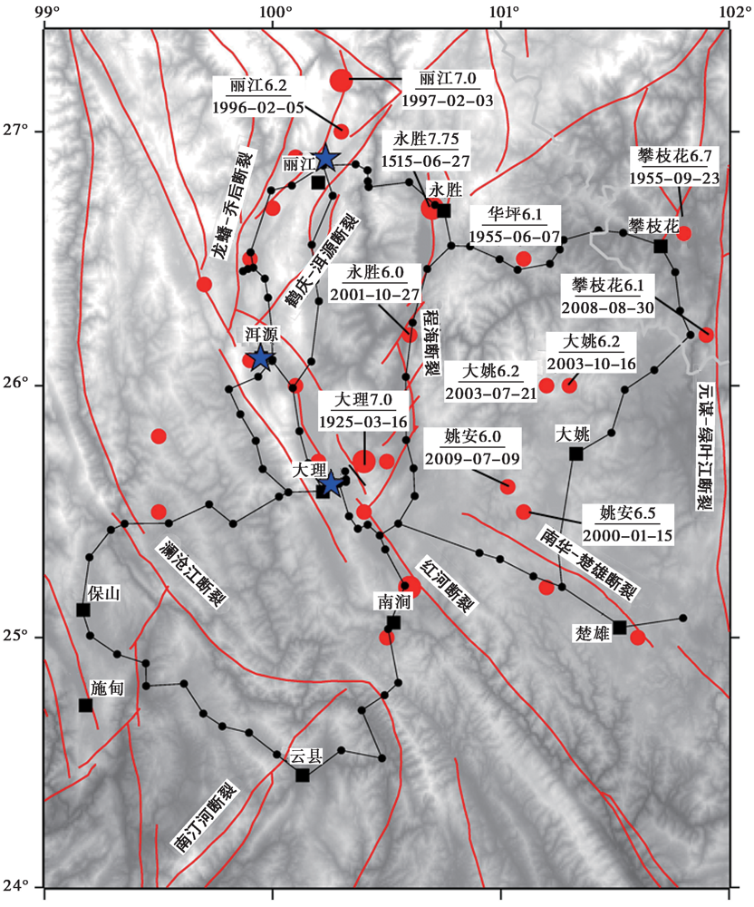
Fig. 1 Gravity network in Western Yunnan Earthquake Prediction Study Area.
| 测点 | 观测期次 | 观测时间(年-月) |
|---|---|---|
| 下关绝对重力观测 | 17 | 1986-04, 1990-04, 1992-04, 1995-04, 1996-05, 1998-06, 1999-04, 2001-12, 2004-05, 2005-10, 2007-11, 2008-10, 2010-12, 2011-12, 2012-10, 2014-05, 2014-10 |
| 丽江绝对重力观测 | 7 | 1986-04, 1990-05, 1992-05, 1995-04, 1996-06, 1998-12, 2001-12 |
| 洱源绝对重力观测 | 8 | 1992-05, 1995-05, 1996-06, 1999-04, 2001-12, 2005-09, 2007-11, 2008-11 |
| 相对重力联测 | 62 | 1986-03-2014-09 |
Table 1 Gravity data
| 测点 | 观测期次 | 观测时间(年-月) |
|---|---|---|
| 下关绝对重力观测 | 17 | 1986-04, 1990-04, 1992-04, 1995-04, 1996-05, 1998-06, 1999-04, 2001-12, 2004-05, 2005-10, 2007-11, 2008-10, 2010-12, 2011-12, 2012-10, 2014-05, 2014-10 |
| 丽江绝对重力观测 | 7 | 1986-04, 1990-05, 1992-05, 1995-04, 1996-06, 1998-12, 2001-12 |
| 洱源绝对重力观测 | 8 | 1992-05, 1995-05, 1996-06, 1999-04, 2001-12, 2005-09, 2007-11, 2008-11 |
| 相对重力联测 | 62 | 1986-03-2014-09 |
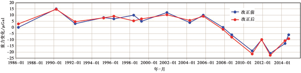
Fig. 2 Gravity variation by absolute gravity observation in Xiaguan station.
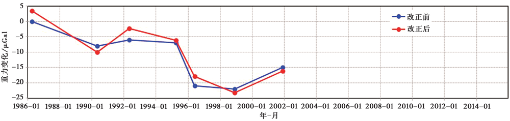
Fig. 3 Gravity variation by absolute gravity observation in Lijiang station.
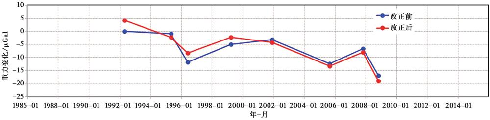
Fig. 4 Gravity variation by absolute gravity observation in Eryuan station.
| 序号 | 北纬/(°) | 东经/(°) | 变化速率/μGal·a-1 | 中误差 /μGal·a-1 | 序号 | 北纬/(°) | 东经/(°) | 变化速率/μGal·a-1 | 中误差 /μGal·a-1 |
|---|---|---|---|---|---|---|---|---|---|
| 1 | 25.202 | 101.268 | -0.97 | 0.21 | 45 | 26.789 | 100.084 | -2.05 | 0.37 |
| 2 | 25.244 | 101.143 | -1.37 | 0.27 | 46 | 26.867 | 100.221 | -2.56 | 0.42 |
| 3 | 25.314 | 100.999 | -0.64 | 0.20 | 47 | 26.749 | 100.263 | -2.94 | 0.32 |
| 4 | 25.329 | 100.899 | -1.84 | 0.26 | 48 | 26.556 | 100.171 | -1.64 | 0.26 |
| 5 | 25.453 | 100.55 | -0.34 | 0.17 | 49 | 26.411 | 100.185 | -2.43 | 0.30 |
| 6 | 25.409 | 100.47 | -1.96 | 0.32 | 50 | 26.334 | 100.202 | -1.40 | 0.23 |
| 7 | 25.436 | 100.375 | -1.91 | 0.28 | 51 | 26.842 | 100.415 | -0.67 | 0.41 |
| 8 | 25.442 | 100.365 | -1.00 | 0.39 | 52 | 26.783 | 100.42 | -0.60 | 0.41 |
| 9 | 25.487 | 100.335 | -1.13 | 0.29 | 53 | 26.802 | 100.598 | -1.04 | 0.28 |
| 10 | 25.661 | 100.317 | -1.31 | 0.32 | 54 | 26.713 | 100.711 | -0.09 | 0.28 |
| 11 | 25.63 | 100.321 | 0.30 | 0.40 | 55 | 26.708 | 100.719 | -1.82 | 0.46 |
| 12 | 25.619 | 100.321 | 0.43 | 0.39 | 56 | 26.687 | 100.751 | -2.45 | 0.26 |
| 13 | 25.581 | 100.223 | -1.86 | 0.19 | 57 | 26.462 | 100.679 | -1.32 | 0.24 |
| 14 | 25.61 | 100.256 | -1.17 | 0.12 | 58 | 26.249 | 100.613 | -1.17 | 0.27 |
| 15 | 25.582 | 100.05 | -1.59 | 0.22 | 59 | 26.158 | 100.573 | -1.75 | 0.50 |
| 16 | 25.453 | 99.826 | -0.84 | 0.43 | 60 | 26.035 | 100.583 | 0.38 | 0.57 |
| 17 | 25.52 | 99.727 | 0.42 | 0.34 | 61 | 25.786 | 100.585 | 1.57 | 0.25 |
| 18 | 25.456 | 99.546 | -0.10 | 0.34 | 62 | 25.563 | 100.622 | -1.31 | 0.36 |
| 19 | 25.452 | 99.352 | 0.77 | 0.48 | 63 | 26.55 | 100.865 | -2.21 | 0.38 |
| 20 | 25.111 | 99.165 | -1.75 | 0.25 | 64 | 26.499 | 100.994 | -2.63 | 0.41 |
| 21 | 24.808 | 99.446 | -1.38 | 0.29 | 65 | 26.481 | 101.215 | -2.03 | 0.35 |
| 22 | 24.646 | 99.779 | -1.04 | 0.34 | 66 | 26.538 | 101.256 | -1.57 | 0.42 |
| 23 | 24.527 | 100.032 | -0.03 | 0.32 | 67 | 26.575 | 101.275 | -1.22 | 0.36 |
| 24 | 24.443 | 100.143 | -0.55 | 0.43 | 68 | 26.613 | 101.425 | 0.12 | 0.29 |
| 25 | 24.486 | 100.307 | -0.41 | 0.38 | 69 | 26.201 | 101.831 | 0.87 | 0.40 |
| 26 | 25.033 | 100.507 | -0.56 | 0.26 | 70 | 26.001 | 101.67 | -2.70 | 0.38 |
| 27 | 25.123 | 100.598 | -0.80 | 0.34 | 71 | 25.984 | 101.544 | -0.41 | 0.34 |
| 28 | 25.207 | 100.58 | -0.87 | 0.34 | 72 | 25.882 | 101.522 | -1.98 | 0.35 |
| 29 | 25.782 | 99.928 | -1.68 | 0.43 | 73 | 25.814 | 101.484 | -2.20 | 0.37 |
| 30 | 25.886 | 99.859 | -2.03 | 0.29 | 74 | 25.735 | 101.323 | -2.34 | 0.34 |
| 31 | 25.986 | 99.809 | -2.45 | 0.44 | 75 | 25.727 | 101.317 | -2.43 | 0.34 |
| 32 | 26.036 | 99.936 | -2.49 | 0.41 | 76 | 26.896 | 100.232 | -1.67 | 0.13 |
| 33 | 26.102 | 99.954 | -0.98 | 0.28 | 77 | 25.61 | 100.256 | -0.68 | 0.29 |
| 34 | 26.097 | 100.002 | -0.64 | 0.20 | 78 | 25.042 | 101.529 | -1.88 | 0.34 |
| 35 | 26.103 | 99.999 | -1.24 | 0.28 | 79 | 25.079 | 101.799 | -2.05 | 0.27 |
| 36 | 25.831 | 100.12 | -0.89 | 0.22 | 80 | 25.14 | 102.061 | -0.62 | 0.29 |
| 37 | 25.694 | 100.155 | -1.52 | 0.31 | 81 | 24.93 | 102.485 | -2.41 | 0.24 |
| 38 | 26.219 | 99.996 | -1.90 | 0.31 | 82 | 24.993 | 102.614 | -0.28 | 0.17 |
| 39 | 26.347 | 99.979 | -1.30 | 0.18 | 83 | 25.148 | 102.747 | -1.16 | 0.12 |
| 40 | 26.424 | 99.965 | -1.67 | 0.22 | 84 | 25.351 | 100.493 | -1.68 | 0.52 |
| 41 | 26.452 | 99.871 | -1.79 | 0.16 | 85 | 24.951 | 102.199 | -1.84 | 0.28 |
| 42 | 26.461 | 99.89 | -1.75 | 0.25 | 86 | 26.552 | 100.782 | 0.46 | 0.33 |
| 43 | 26.526 | 99.903 | -2.40 | 0.34 | 87 | 25.611 | 100.291 | 1.57 | 0.28 |
| 44 | 26.625 | 99.955 | -3.01 | 0.61 |
Table 2 Gravity variation rate of gravity stations
| 序号 | 北纬/(°) | 东经/(°) | 变化速率/μGal·a-1 | 中误差 /μGal·a-1 | 序号 | 北纬/(°) | 东经/(°) | 变化速率/μGal·a-1 | 中误差 /μGal·a-1 |
|---|---|---|---|---|---|---|---|---|---|
| 1 | 25.202 | 101.268 | -0.97 | 0.21 | 45 | 26.789 | 100.084 | -2.05 | 0.37 |
| 2 | 25.244 | 101.143 | -1.37 | 0.27 | 46 | 26.867 | 100.221 | -2.56 | 0.42 |
| 3 | 25.314 | 100.999 | -0.64 | 0.20 | 47 | 26.749 | 100.263 | -2.94 | 0.32 |
| 4 | 25.329 | 100.899 | -1.84 | 0.26 | 48 | 26.556 | 100.171 | -1.64 | 0.26 |
| 5 | 25.453 | 100.55 | -0.34 | 0.17 | 49 | 26.411 | 100.185 | -2.43 | 0.30 |
| 6 | 25.409 | 100.47 | -1.96 | 0.32 | 50 | 26.334 | 100.202 | -1.40 | 0.23 |
| 7 | 25.436 | 100.375 | -1.91 | 0.28 | 51 | 26.842 | 100.415 | -0.67 | 0.41 |
| 8 | 25.442 | 100.365 | -1.00 | 0.39 | 52 | 26.783 | 100.42 | -0.60 | 0.41 |
| 9 | 25.487 | 100.335 | -1.13 | 0.29 | 53 | 26.802 | 100.598 | -1.04 | 0.28 |
| 10 | 25.661 | 100.317 | -1.31 | 0.32 | 54 | 26.713 | 100.711 | -0.09 | 0.28 |
| 11 | 25.63 | 100.321 | 0.30 | 0.40 | 55 | 26.708 | 100.719 | -1.82 | 0.46 |
| 12 | 25.619 | 100.321 | 0.43 | 0.39 | 56 | 26.687 | 100.751 | -2.45 | 0.26 |
| 13 | 25.581 | 100.223 | -1.86 | 0.19 | 57 | 26.462 | 100.679 | -1.32 | 0.24 |
| 14 | 25.61 | 100.256 | -1.17 | 0.12 | 58 | 26.249 | 100.613 | -1.17 | 0.27 |
| 15 | 25.582 | 100.05 | -1.59 | 0.22 | 59 | 26.158 | 100.573 | -1.75 | 0.50 |
| 16 | 25.453 | 99.826 | -0.84 | 0.43 | 60 | 26.035 | 100.583 | 0.38 | 0.57 |
| 17 | 25.52 | 99.727 | 0.42 | 0.34 | 61 | 25.786 | 100.585 | 1.57 | 0.25 |
| 18 | 25.456 | 99.546 | -0.10 | 0.34 | 62 | 25.563 | 100.622 | -1.31 | 0.36 |
| 19 | 25.452 | 99.352 | 0.77 | 0.48 | 63 | 26.55 | 100.865 | -2.21 | 0.38 |
| 20 | 25.111 | 99.165 | -1.75 | 0.25 | 64 | 26.499 | 100.994 | -2.63 | 0.41 |
| 21 | 24.808 | 99.446 | -1.38 | 0.29 | 65 | 26.481 | 101.215 | -2.03 | 0.35 |
| 22 | 24.646 | 99.779 | -1.04 | 0.34 | 66 | 26.538 | 101.256 | -1.57 | 0.42 |
| 23 | 24.527 | 100.032 | -0.03 | 0.32 | 67 | 26.575 | 101.275 | -1.22 | 0.36 |
| 24 | 24.443 | 100.143 | -0.55 | 0.43 | 68 | 26.613 | 101.425 | 0.12 | 0.29 |
| 25 | 24.486 | 100.307 | -0.41 | 0.38 | 69 | 26.201 | 101.831 | 0.87 | 0.40 |
| 26 | 25.033 | 100.507 | -0.56 | 0.26 | 70 | 26.001 | 101.67 | -2.70 | 0.38 |
| 27 | 25.123 | 100.598 | -0.80 | 0.34 | 71 | 25.984 | 101.544 | -0.41 | 0.34 |
| 28 | 25.207 | 100.58 | -0.87 | 0.34 | 72 | 25.882 | 101.522 | -1.98 | 0.35 |
| 29 | 25.782 | 99.928 | -1.68 | 0.43 | 73 | 25.814 | 101.484 | -2.20 | 0.37 |
| 30 | 25.886 | 99.859 | -2.03 | 0.29 | 74 | 25.735 | 101.323 | -2.34 | 0.34 |
| 31 | 25.986 | 99.809 | -2.45 | 0.44 | 75 | 25.727 | 101.317 | -2.43 | 0.34 |
| 32 | 26.036 | 99.936 | -2.49 | 0.41 | 76 | 26.896 | 100.232 | -1.67 | 0.13 |
| 33 | 26.102 | 99.954 | -0.98 | 0.28 | 77 | 25.61 | 100.256 | -0.68 | 0.29 |
| 34 | 26.097 | 100.002 | -0.64 | 0.20 | 78 | 25.042 | 101.529 | -1.88 | 0.34 |
| 35 | 26.103 | 99.999 | -1.24 | 0.28 | 79 | 25.079 | 101.799 | -2.05 | 0.27 |
| 36 | 25.831 | 100.12 | -0.89 | 0.22 | 80 | 25.14 | 102.061 | -0.62 | 0.29 |
| 37 | 25.694 | 100.155 | -1.52 | 0.31 | 81 | 24.93 | 102.485 | -2.41 | 0.24 |
| 38 | 26.219 | 99.996 | -1.90 | 0.31 | 82 | 24.993 | 102.614 | -0.28 | 0.17 |
| 39 | 26.347 | 99.979 | -1.30 | 0.18 | 83 | 25.148 | 102.747 | -1.16 | 0.12 |
| 40 | 26.424 | 99.965 | -1.67 | 0.22 | 84 | 25.351 | 100.493 | -1.68 | 0.52 |
| 41 | 26.452 | 99.871 | -1.79 | 0.16 | 85 | 24.951 | 102.199 | -1.84 | 0.28 |
| 42 | 26.461 | 99.89 | -1.75 | 0.25 | 86 | 26.552 | 100.782 | 0.46 | 0.33 |
| 43 | 26.526 | 99.903 | -2.40 | 0.34 | 87 | 25.611 | 100.291 | 1.57 | 0.28 |
| 44 | 26.625 | 99.955 | -3.01 | 0.61 |
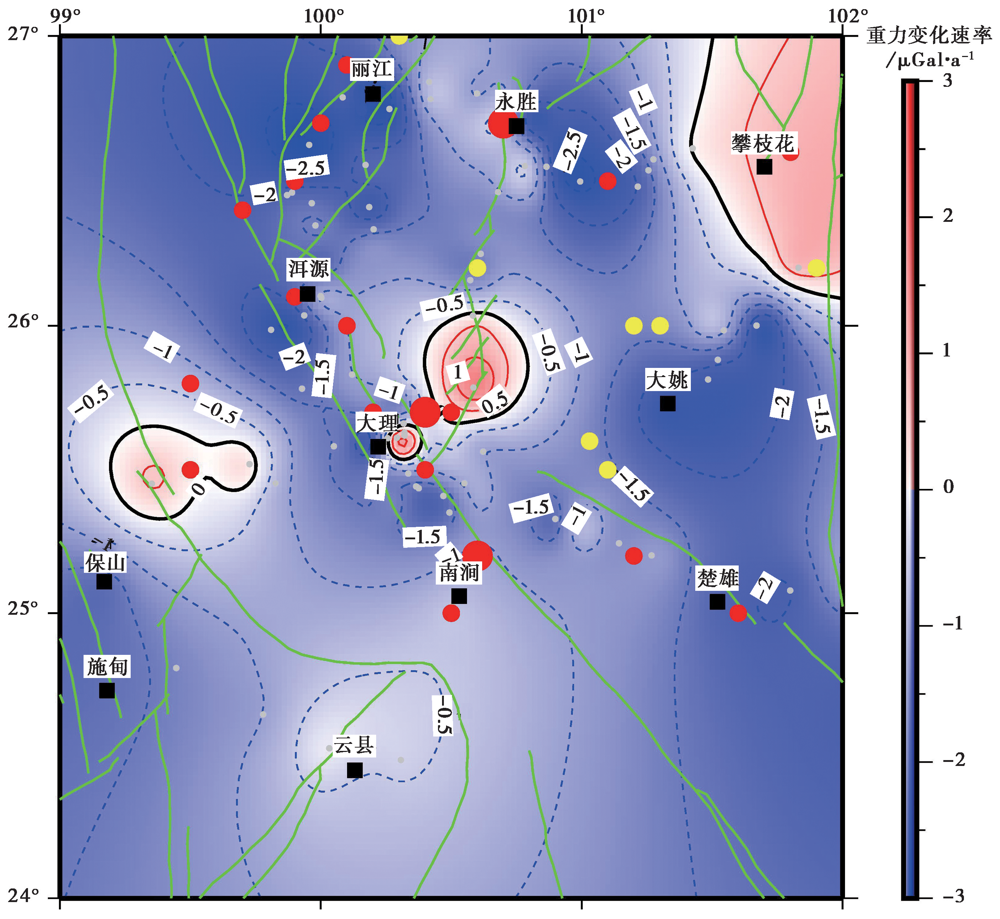
Fig. 5 Distribution of long-term variation of gravity field.
| 序号 | 发震时间 | 参考地点 | 震级 |
|---|---|---|---|
| 1 | 1997-02-04 | 丽江 | 6.0 |
| 2 | 2001-01-14 | 姚安 | 6.5 |
| 3 | 2001-10-27 | 永胜 | 6.0 |
| 4 | 2003-07-21 | 大姚 | 6.2 |
| 5 | 2003-10-16 | 大姚 | 6.2 |
| 6 | 2008-08-30 | 攀枝花 | 6.1 |
| 7 | 2009-07-09 | 姚安 | 6.0 |
Table 3 Earthquakes with M≥6 during observation period of the gravity data
| 序号 | 发震时间 | 参考地点 | 震级 |
|---|---|---|---|
| 1 | 1997-02-04 | 丽江 | 6.0 |
| 2 | 2001-01-14 | 姚安 | 6.5 |
| 3 | 2001-10-27 | 永胜 | 6.0 |
| 4 | 2003-07-21 | 大姚 | 6.2 |
| 5 | 2003-10-16 | 大姚 | 6.2 |
| 6 | 2008-08-30 | 攀枝花 | 6.1 |
| 7 | 2009-07-09 | 姚安 | 6.0 |
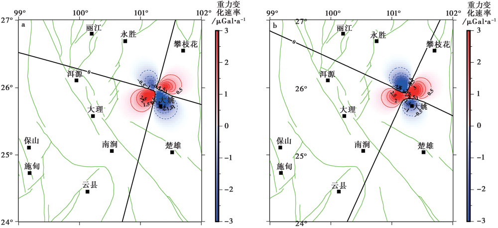
Fig. 6 Coseismic gravity variations of the 2003 Dayao MS6.2 and MS6.1 earthquakes.
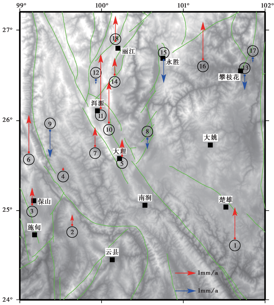
Fig. 7 Vertical displacement observed by GNSS.
| 序号 | 东经/(°) | 北纬/(°) | ΔH/mm·a-1 | g1/μGal·a-1 | g2/μGal·a-1 | g3/μGal·a-1 | g4/μGal·a-1 |
|---|---|---|---|---|---|---|---|
| 1 | 101.63 | 24.69 | 1.5 | -0.463 | -1.820 | -1.57 | -1.107 |
| 2 | 99.64 | 24.84 | 0.5 | -0.154 | -1.113 | -0.863 | -0.709 |
| 3 | 99.15 | 25.07 | 0.8 | -0.247 | -1.738 | -1.488 | -1.241 |
| 4 | 99.53 | 25.46 | 0.1 | -0.031 | 0.025 | 0.275 | 0.306 |
| 5 | 100.25 | 25.61 | 0.8 | -0.247 | -0.320 | -0.07 | 0.177 |
| 6 | 99.11 | 25.65 | 1.8 | -0.555 | -0.364 | -0.114 | 0.441 |
| 7 | 99.92 | 25.72 | 0.9 | -0.278 | -1.456 | -1.206 | -0.928 |
| 8 | 100.56 | 25.80 | -0.5 | 0.154 | 1.315 | 1.565 | 1.411 |
| 9 | 99.37 | 25.89 | -1.3 | 0.401 | -0.839 | -0.589 | -0.99 |
| 10 | 100.09 | 25.98 | 2.0 | -0.617 | -1.066 | -0.816 | -0.199 |
| 11 | 99.99 | 26.14 | 2.6 | -0.802 | -1.236 | -0.986 | -0.184 |
| 12 | 99.93 | 26.45 | -0.2 | 0.062 | -1.803 | -1.553 | -1.615 |
| 13 | 101.75 | 26.50 | -0.7 | 0.216 | 0.702 | 0.952 | 0.736 |
| 14 | 100.16 | 26.51 | 0.8 | -0.247 | -1.941 | -1.691 | -1.444 |
| 15 | 100.76 | 26.67 | -1.1 | 0.339 | -1.414 | -1.164 | -1.503 |
| 16 | 101.24 | 26.68 | 1.8 | -0.555 | -1.209 | -0.959 | -0.404 |
| 17 | 101.85 | 26.69 | -0.2 | 0.062 | 0.774 | 1.024 | 0.962 |
| 18 | 100.17 | 26.88 | 1.2 | -0.370 | -2.143 | -1.893 | -1.523 |
| 平均 | 0.815 | -0.252 | -1.034 | -0.784 | -0.532 |
Table 4 Vertical displacement and gravity variation
| 序号 | 东经/(°) | 北纬/(°) | ΔH/mm·a-1 | g1/μGal·a-1 | g2/μGal·a-1 | g3/μGal·a-1 | g4/μGal·a-1 |
|---|---|---|---|---|---|---|---|
| 1 | 101.63 | 24.69 | 1.5 | -0.463 | -1.820 | -1.57 | -1.107 |
| 2 | 99.64 | 24.84 | 0.5 | -0.154 | -1.113 | -0.863 | -0.709 |
| 3 | 99.15 | 25.07 | 0.8 | -0.247 | -1.738 | -1.488 | -1.241 |
| 4 | 99.53 | 25.46 | 0.1 | -0.031 | 0.025 | 0.275 | 0.306 |
| 5 | 100.25 | 25.61 | 0.8 | -0.247 | -0.320 | -0.07 | 0.177 |
| 6 | 99.11 | 25.65 | 1.8 | -0.555 | -0.364 | -0.114 | 0.441 |
| 7 | 99.92 | 25.72 | 0.9 | -0.278 | -1.456 | -1.206 | -0.928 |
| 8 | 100.56 | 25.80 | -0.5 | 0.154 | 1.315 | 1.565 | 1.411 |
| 9 | 99.37 | 25.89 | -1.3 | 0.401 | -0.839 | -0.589 | -0.99 |
| 10 | 100.09 | 25.98 | 2.0 | -0.617 | -1.066 | -0.816 | -0.199 |
| 11 | 99.99 | 26.14 | 2.6 | -0.802 | -1.236 | -0.986 | -0.184 |
| 12 | 99.93 | 26.45 | -0.2 | 0.062 | -1.803 | -1.553 | -1.615 |
| 13 | 101.75 | 26.50 | -0.7 | 0.216 | 0.702 | 0.952 | 0.736 |
| 14 | 100.16 | 26.51 | 0.8 | -0.247 | -1.941 | -1.691 | -1.444 |
| 15 | 100.76 | 26.67 | -1.1 | 0.339 | -1.414 | -1.164 | -1.503 |
| 16 | 101.24 | 26.68 | 1.8 | -0.555 | -1.209 | -0.959 | -0.404 |
| 17 | 101.85 | 26.69 | -0.2 | 0.062 | 0.774 | 1.024 | 0.962 |
| 18 | 100.17 | 26.88 | 1.2 | -0.370 | -2.143 | -1.893 | -1.523 |
| 平均 | 0.815 | -0.252 | -1.034 | -0.784 | -0.532 |
| [1] | 陈运泰, 顾浩鼎, 卢造勋. 1980. 1975年海城地震与1976年唐山地震前后的重力变化[J]. 地震学报, 2(1): 21-31. |
| CHEN Yun-tai, GU Hao-ding, LU Zao-xun. 1980. Variations of gravity before and after the Haicheng earthquake, 1975 and the Tangshan earthquake, 1976[J]. Acta Seismologica Sinica, 2(1): 21-31. (in Chinese) | |
| [2] | 陈云雁. 2015. 云南地区地壳速度结构与动力学机制研究[D]. 昆明: 云南大学. |
| CHEN Yun-yan. 2015. Velocity structure and dynamics mechanism in crust beneath Yunnan Province[D]. Yunnan University, Kunming. (in Chinese) | |
| [3] | 邓嘉美, 金明培, 赵家本, 等. 2014. 云南地区地壳厚度与泊松比变化及其意义[J]. 中国地震, 30(4): 583-596. |
| DENG Jia-mei, JIN Ming-pei, ZHAO Jia-ben, et al. 2014. Tectonic implications from the distribution map of the crust thickness and Poisson’s ratio in the Yunnan area[J]. Earthquake Research in China, 30(4): 583-596. (in Chinese) | |
| [4] | 顾国华. 2005. GPS观测得到的中国大陆地壳垂直运动[J]. 地震, 25(3): 1-8. |
| GU Guo-hua. 2005. Vertical crustal movement obtained from GPS observation in China’s mainland[J]. Earthquake, 25(3): 1-8. (in Chinese) | |
| [5] | 国家地震局地质研究所, 云南省地震局. 1990. 滇西北地区活动断裂[M]. 北京: 地震出版社. |
| Institute of Geology, State Seismological Bureau, Seismological Bureau of Yunnan Province. 1990. Active Fault in Northwestern Yunnan Area[M]. Seismological Press, Beijing. (in Chinese) | |
| [6] | 郭良迁, 塔拉, 陈阜超, 等. 2013. 云南地区地壳垂直运动与地震的关系[J]. 大地测量与地球动力学, 33(1): 1-5. |
| GUO Liang-qian, TA La, CHEN Fu-chao, et al. 2013. Relation between crustal vertical motion and earthquake in Yunnan area[J]. Journal of Geodesy and Geodynamic, 33(1): 1-5. (in Chinese) | |
| [7] | 郭有光, 李德禧, 黄大伦, 等. 1990. 高精度绝对重力仪观测研究[J]. 地球物理学报, 33(4): 447-453. |
| GUO You-guang, LI De-xi, HUANG Da-lun, et al. 1990. Observation study of a high accuracy and absolute gravimeter[J]. Chinese Journal of Geophysics, 33(4): 447-453. | |
| [8] | 韩月萍, 杨国华, 高艳龙, 等. 2009. 云南中部及周围地区近期地壳形变特征[J]. 大地测量与地球动力学, 29(6): 64-67. |
| HAN Yue-ping, YANG Guo-hua, GAO Yan-long, et al. 2009. Characteristics of recent crustal deformation in median and surrounding areas of Yunnan[J]. Journal of Geodesy and Geodynamic, 29(6): 64-67. (in Chinese) | |
| [9] | 郝洪涛, 李辉, 胡敏章, 等. 2015. 芦山地震科学考察观测到的重力变化[J]. 大地测量与地球动力学, 35(2): 331-335, 341. |
| HAO Hong-tao, LI Hui, HU Min-zhang, et al. 2015. Gravity variation observed by scientific expedition of Lushan earthquake[J]. Journal of Geodesy and Geodynamics, 35(2): 331-335, 341. (in Chinese) | |
| [10] | 郝洪涛, 李辉, 刘子维, 等. 2011. 基于重力差方法检测重力仪一次项格值系数变化[J]. 大地测量与地球动力学, 31(1): 87-90. |
| HAO Hong-tao, LI Hui, LIU Zi-wei, et al. 2011. Study on change of scale parameters in linear term of gravimeter with gravity difference method[J]. Journal of Geodesy and Geodynamics, 31(1): 87-90. (in Chinese) | |
| [11] | 郝洪涛, 李辉, 孙和平, 等. 2016. CG-5重力仪零漂改正及格值系数检测应用研究[J]. 武汉大学学报(信息科学版), 41(9): 1265-1271. |
| HAO Hong-tao, LI Hui, SUN He-ping, et al. 2016. Application study of zero drift correct and detection of scale parameters of CG-5gravimeter[J]. Geomatics and Information Science of Wuhan University, 41(9): 1265-1271. (in Chinese) | |
| [12] | 郝明. 2012. 基于精密水准数据的青藏高原东缘现今地壳垂直运动与典型地震同震及震后垂直形变研究[D]. 北京: 中国地震局地质研究所. |
| HAO Ming. 2012. Present crustal vertical movement of eastern Tibetan plateau and coseismic and postseismic vertical deformation of two typical earthquakes[D]. Institute of Geology, China Earthquake Administration, Beijing. (in Chinese) | |
| [13] | 胡敏章, 郝洪涛, 李辉, 等. 2019. 地震分析预报的重力变化异常指标分析[J]. 中国地震, 35(3): 417-430. |
| HU Min-zhang, HAO Hong-tao, LI Hui, et al. 2019. Quantitative analysis of gravity changes for earthquake prediction[J]. Earthquake Research in China, 35(3): 417-430. (in Chinese) | |
| [14] | 虎雄林, 解朝娣, 刘丽芳. 2013. 2003年大姚6.2、 6.1级地震构造应力环境及静态应力触发研究[J]. 地震研究, 36(1): 47-56. |
| HU Xiong-lin, XIE Zhao-di, LIU Li-fang. 2013. Research on tectonic stress environment and static stress trigger of Dayao M6.2, M6.1 earthquakes[J]. Journal of Seismological Research, 36(1): 47-56. (in Chinese) | |
| [15] | 华卫, 刘杰, 郑斯华, 等. 2006. 2003年云南大姚6.2、 6.1级地震序列特征分析及地震触发研究[J]. 中国地震, 22(1): 10-23. |
| HUA Wei, LIU Jie, ZHENG Si-hua, et al. 2006. The characteristic analysis and seismic triggering study of the Dayao M6.2 and M6.1 earthquake sequences in 2003[J]. Earthquake Research in China, 22(1): 10-23. (in Chinese) | |
| [16] | 黄浩哲, 申重阳, 谈洪波, 等. 2019. 姚安 MS6.0 地震典型重力前兆孕震模型量化研究[J]. 大地测量与地球动力学, 39(4): 351-355. |
| HUANG Hao-zhe, SHEN Chong-yang, TAN Hong-bo, et al. 2019. Quantitative research on the seismic model of typical gravity precursors in Yao’an MS6.0 earthquake[J]. Journal of Geodesy and Geodynamic, 39(4): 351-355. (in Chinese) | |
| [17] | 贾民育, 邢灿飞, 李辉, 等. 1999. 绝对重力测量在云南和北京观测到的重力时间变化[J]. 中国地震, 15(1): 54-64. |
| JIA Min-yu, XING Can-fei, LI Hui, et al. 1999. Gravity changes with time in Yunnan and Beijing observed by absolute gravimetry[J]. Earthquake Research in China, 15(1): 54-64. (in Chinese) | |
| [18] | 贾民育, 邢灿飞, 孙少安. 1995. 滇西重力变化的二维图象及其与5级(MS)以上地震的关系[J]. 地壳形变与地震, 15(3): 9-19. |
| JIA Min-yu, XING Can-fei, SUN Shao-an. 1995. Two dimension pictures of gravity change in western Yunnan and their relations to the earthquakes MS>5.0[J]. Crustal Deformation and Earthquake, 15(3): 9-19. (in Chinese) | |
| [19] | 李辉, 付广裕, 孙少安, 等. 2000. 滇西地区重力场动态变化计算[J]. 地壳形变与地震, 20(1): 60-66. |
| LI Hui, FU Guang-yu, SUN Shao-an, et al. 2000. Computation on dynamic gravity changes in the western area of Yunnan Province[J]. Crustal Deformation and Earthquake, 20(1): 60-66. (in Chinese) | |
| [20] | 刘经南, 姚宜斌, 施闯, 等. 2002. 中国大陆现今垂直形变特征的初步探讨[J]. 大地测量与地球动力学, 22(3): 1-5. |
| LIU Jing-nan, YAO Yi-bin, SHI Chuang, et al. 2002. Preliminary research on characteristic of present-day vertical deformation of China mainland[J]. Journal of Geodesy and Geodynamic, 22(3): 1-5. (in Chinese) | |
| [21] | 罗荣联, 陈玉茹. 1996. 云南历史强震活动图象[J]. 地震研究, 19(3): 253-259. |
| LUO Rong-lian, CHEN Yu-ru. 1996. Historical strong seismicity pattern in Yunnan[J]. Journal of Seismological Research, 19(3): 253-259. (in Chinese) | |
| [22] | 罗睿洁, 吴中海, 黄小龙, 等. 2015. 滇西北宾川地区主要活动断裂及其活动构造体系[J]. 地质通报, 34(1): 155-170. |
| LUO Rui-jie, WU Zhong-hai, HUANG Xiao-long, et al. 2015. The main active faults and the active tectonic system of Binchuan area, northwestern Yunnan[J]. Geological Bulletin of China, 34(1): 155-170. (in Chinese) | |
| [23] | 申重阳. 2005. 地壳形变与密度变化耦合运动探析[J]. 大地测量与地球动力学, 25(3): 7-12. |
| SHEN Chong-yang. 2005. Preliminary analysis of coupling movement between crustal deformation and density change[J]. Journal of Geodesy and Geodynamic, 25(3): 7-12. (in Chinese) | |
| [24] | 申重阳, 李辉, 付广裕. 2003. 丽江7.0级地震重力前兆模式研究[J]. 地震学报, 25(2): 163-171, 228. |
| SHEN Chong-yang, LI Hui, FU Guang-yu. 2003. Study on a gravity precursor mode of Lijiang earthquake with MS=7.0[J]. Acta Seismologica Sinica, 25(2): 163-171, 228. (in Chinese) | |
| [25] | 申重阳, 谈洪波, 郝洪涛, 等. 2011. 2009年姚安 MS6.0 地震重力场前兆变化机理[J]. 大地测量与地球动力学, 31(2): 17-22, 47. |
| SHEN Chong-yang, TAN Hong-bo, HAO Hong-tao, et al. 2011. Mechanism of precursory gravity change before Yao’an MS6.0 earthquake in 2009[J]. Journal of Geodesy and Geodynamic, 31(2): 17-22, 47. (in Chinese) | |
| [26] | 申重阳, 祝意青, 胡敏章, 等. 2020. 中国大陆重力场时变监测与强震预测[J]. 中国地震, 36(4): 729-743. |
| SHEN Chong-yang, ZHU Yi-qing, HU Min-zhang, et al. 2020. Time-varying gravity field monitoring and strong earthquake prediction on the Chinese mainland[J]. Earthquake Research in China, 36(4): 729-743. (in Chinese) | |
| [27] |
苏广利, 畅柳, 许明元. 2018. 基于精密水准的云南地区垂直运动特征分析[J]. 地震地质, 40(6): 1380-1389. doi: 10.3969/j.issn.0253-4967.2018.06.01.
DOI |
| SU Guang-li, CHANG Liu, XU Ming-yuan. 2018. The analysis of vertical motion characteristics in Yunnan area based on precise leveling[J]. Seismology and Geology, 40(6): 1380-1389. (in Chinese) | |
| [28] | 苏有锦, 刘祖荫, 蔡民军, 等. 1999. 云南地区强震分布的深部地球介质背景[J]. 地震学报, 21(3): 313-322. |
| SU You-jin, LIU Zu-yin, CAI Min-jun, et al. 1999. Deep medium environment of strong earthquakes occurrence in Yunnan region[J]. Acta Seismologica Sinica, 21(3): 313-322(in Chinese). | |
| [29] | 谈洪波, 申重阳, 李辉. 2008. 断层位错引起的地表重力变化特征研究[J]. 大地测量与地球动力学, 28(4): 54-62. |
| TAN Hong-bo, SHEN Chong-yang, LI Hui. 2008. Characteristics of surface gravity changes caused by a fault or faults dislocation[J]. Journal of Geodesy and Geodynamic, 28(4): 54-62. (in Chinese) | |
| [30] | 王勇, 张为民, 詹金刚, 等. 2004. 重复绝对重力测量观测的滇西地区和拉萨点的重力变化及其意义[J]. 地球物理学报, 47(1): 95-100. |
| WANG Yong, ZHANG Wei-min, ZHAN Jin-gang, et al. 2004. Gravity change detected by repeated absolute gravity measurements in the western Yunnan and Lhasa, China and its implication[J]. Chinese Journal of Geophysics, 47(1): 95-100. (in Chinese) | |
| [31] | 邢乐林. 2014. 绝对重力基准建立及其在地球动力学中的应用[D]. 武汉: 武汉大学. |
| XING Le-lin. 2014. Determination of absolute gravity datum and its application in geodynamics[D]. Wuhan University, Wuhan. (in Chinese) | |
| [32] |
徐志萍, 王夫运, 姜磊, 等. 2018. 川滇地区莫霍面深度和地壳厚度[J]. 地震地质, 40(6): 1318-1331. doi: 10.3969 /j.issn.0253-4967.2018.06.009.
DOI |
| XU Zhi-ping, WANG Fu-yun, JIANG Lei, et al. 2018. The depth of Moho interface and crustal thickness in Sichuan-Yunnan region, China[J]. Seismology and Geology, 40(6): 1318-1331. (in Chinese) | |
| [33] | 杨文采, 侯遵泽, 徐义贤, 等. 2017. 青藏高原下地壳热变形和管道流研究[J]. 地质论评, 63(5): 1141-1152. |
| YANG Wen-cai, HOU Zun-ze, XU Yi-xian, et al. 2017. A study on thermal deformation and lower crust channel flows in Qinghai-Xizang(Tibet) Plateau[J]. Geological Review, 63(5): 1141-1152. (in Chinese) | |
| [34] | 杨文采, 侯遵泽, 于常青. 2015a. 滇西地壳三维密度结构及其大地构造含义[J]. 地球物理学报, 58(11): 3902-3916. |
| YANG Wen-cai, HOU Zun-ze, YU Chang-qing. 2015a. 3D crustal density structure of West Yunnan and its tectonic implication[J]. Chinese Journal of Geophysics, 58(11): 3902-3916. (in Chinese) | |
| [35] | 杨文采, 侯遵泽, 于常青. 2015b. 青藏高原地壳的三维密度结构和物质运动[J]. 地球物理学报, 58(11): 4223-4234. |
| YANG Wen-cai, HOU Zun-ze, YU Chang-qing. 2015b. Three-dimensional density structure of the Tibetan plateau and crustal mass movement[J]. Chinese Journal of Geophysics, 58(11): 4223-4234. (in Chinese) | |
| [36] | 查小惠, 雷建设. 2013. 云南地区地壳厚度和泊松比研究[J]. 中国科学(D辑), 43(3): 446-456. |
|
ZHA Xiao-hui, LEI Jian-she. 2013. Crustal thickness and Poisson’s ratio beneath the Yunnan region[J]. Science China: Earth Sciences, 56(4): 693-702.
DOI URL |
|
| [37] | 占伟. 2017. 基于GPS连续观测的中国大陆典型区域地壳垂直运动研究[D]. 武汉: 武汉大学. |
| ZHAN Wei. 2017. Study on vertical crustal motion in Chinese mainland and typical areas based on continuous GPS[D]. Wuhan University, Wuhan. (in Chinese) | |
| [38] | 赵斌, 聂兆生, 黄勇, 等. 2014. 大规模 GPS 揭示的华北地区现今垂直运动[J]. 大地测量与地球动力学, 34(5): 35-39. |
| ZHAO Bin, NIE Zhao-sheng, HUANG Yong, et al. 2014. Vertical motion of North China inferred from dense GPS measurements[J]. Journal of Geodesy and Geodynamics, 34(5): 35-39. (in Chinese) | |
| [39] | 朱介寿, 王绪本, 杨宜海, 等. 2017. 青藏高原东缘的地壳流及动力过程[J]. 地球物理学报, 60(6): 2038-2057. |
| ZHU Jie-shou, WANG Xu-ben, YANG Yi-hai, et al. 2017. The crustal flow beneath the eastern margin of the Tibetan plateau and its process of dynamics[J]. Chinese Journal of Geophysics, 60(6): 2038-2057. (in Chinese) | |
| [40] | 祝意青, 郭树松, 刘芳. 2010. 攀枝花6.1、 姚安6.0级地震前后区域重力场变化[J]. 大地测量与地球动力学, 30(4): 8-11, 18. |
| ZHU Yi-qing, GUO Shu-song, LIU Fang. 2010. Variation of gravity field before and after Panzhihua MS6.1 and Yao’an MS6.0 earthquakes[J]. Journal of Geodesy and Geodynamic, 30(4): 8-11, 18. (in Chinese) | |
| [41] | 祝意青, 梁伟锋, 湛飞并, 等. 2012. 中国大陆重力场动态变化研究[J]. 地球物理学报, 55(3): 804-813. |
| ZHU Yi-qing, LIANG Wei-feng, ZHAN Fei-bing, et al. 2012. Study on dynamic change of gravity field in China continent[J]. Chinese Journal of Geophysics, 55(3): 804-813. (in Chinese) | |
| [42] | 祝意青, 申重阳, 张国庆, 等. 2018. 我国流动重力监测预报发展之再思考[J]. 大地测量与地球动力学, 38(5): 441-446. |
| ZHU Yi-qing, SHEN Chong-yang, ZHANG Guo-qing, et al. 2018. Rethinking the development of earthquake monitoring and prediction in mobile gravity[J]. Journal of Geodesy and Geodynamic, 38(5): 441-446. (in Chinese) | |
| [43] | 祝意青, 张勇, 张国庆, 等. 2020. 21世纪以来青藏高原大震前重力变化[J]. 科学通报, 65(7): 622-632. |
| ZHU Yi-qing, ZHANG Yong, ZHANG Guo-qing, et al. 2020. Gravity variations preceding the large earthquakes in the Qinghai-Tibet Plateau from 21st century[J]. Chinese Science Bulletin, 65(7): 622-632. (in Chinese) | |
| [44] | Bai D H, Teng J W, Ma X B, et al. 2011. Crustal flows beneath the eastern Tibetan plateau revealed by magnetotelluric observations[J]. Bulletin of the Chinese Academy of Sciences, 25(4): 303-304. |
| [45] |
Barnes D F. 1966. Gravity changes during the Alaska earthquake[J]. Journal of Geophysical Research, 71(2): 451-456.
DOI URL |
| [46] | Bonvalot S, Remy D, Deplus C, et al. 2008. Insights on the March 1998 eruption at Piton de la Fournaise volcano(La Réunion)from microgravity monitoring[J]. Journal of Geophysical Research: Solid Earth, 113(B5): B05407. |
| [47] |
Fujii Y. 1966. Gravity changes in the shock area of the Niigata earthquake, 16 June 1964[J]. Zisin, 19(3): 200-216.
DOI URL |
| [48] | Furuya M, Okubo S, Sun W K, et al. 2003. Spatiotemporal gravity changes at Miyakejima volcano, Japan: Caldera collapse, explosive eruptions and magma movement[J]. Journal of Geophysical Research: Solid Earth, 108(B4): ECV8-1-ECV8-17. |
| [49] |
Hunt T M. 1970. Gravity changes associated with the 1968 Inangahua earthquake[J]. New Zealand Journal of Geology and Geophysics, 13(4): 1050-1051.
DOI URL |
| [50] |
Liang S M, Gan W J, Shen C Z, et al. 2013. Three-dimensional velocity field of present-day crustal motion of the Tibetan plateau derived from GPS measurements[J]. Journal of Geophysical Research: Solid Earth, 118(10): 5722-5732.
DOI URL |
| [51] | Okubo S. 1992. Gravity and potential changes due to shear and tensile faults in a half-space[J]. Journal of Geophysical Research: Solid Earth, 97(B5): 7137-7144. |
| [52] | Pagiatakis S D, Salib P. 2003. Historical relative gravity observations and the time rate of change of gravity due to postglacial rebound and other tectonic movements in Canada[J]. Journal of Geophysical Research: Solid Earth, 108(B9): ETG1-1-ETG1-16. |
| [53] |
Rymer H, Brown G C. 1986. Gravity fields and the interpretation of volcanic structures: Geological discrimination and temporal evolution[J]. Journal of Volcanology and Geothermal Research, 27(3-4): 229-254.
DOI URL |
| [54] | Sun W K, Wang Q, Li H, et al. 2009. Gravity and GPS measurements reveal mass loss beneath the Tibetan plateau: Geodetic evidence of increasing crustal thickness[J]. Geophysical Research Letters, 36(2): L02303. |
| [55] | Torge W. 1989. Gravimetry[M]. Walter de Gruyter & Co, Berlin. |
| [1] | WANG Min, SHEN Zheng-kang. WAS THERE SIGNIFICANT VERTICAL CRUSTAL MOTION IN EPICENTRAL REGION PRIOR TO 2008 GREAT WENCHUAN EARTHQUAKE? [J]. SEISMOLOGY AND GEOLOGY, 2014, 36(4): 956-963. |
| Viewed | ||||||
|
Full text |
|
|||||
|
Abstract |
|
|||||
