SEISMOLOGY AND GEOLOGY ›› 2022, Vol. 44 ›› Issue (4): 961-975.DOI: 10.3969/j.issn.0253-4967.2022.04.009
• Research paper • Previous Articles Next Articles
LU Ben-tian( ), LI Zhi-gang, LIANG Hao*(), YANG Jing-jun, ZHENG Wen-jun
Received:2021-05-06
Revised:2021-06-09
Online:2022-08-20
Published:2022-09-23
Contact:
LIANG Hao
卢本添(), 李志刚, 梁浩*(), 杨敬钧, 郑文俊
通讯作者:
梁浩
作者简介:卢本添, 男, 1994年生, 2021年于中山大学地球科学与工程学院获构造地质学硕士学位, 主要从事河流地貌研究和水文测报等工作, E-mail: 991098578@qq.com。
基金资助:CLC Number:
LU Ben-tian, LI Zhi-gang, LIANG Hao, YANG Jing-jun, ZHENG Wen-jun. THE RESPONSE OF FLUVIAL LANDFORM TO THE EVOLU-TION OF FAULT STRUCTURE IN THE NORTHERN ZHONGTIAO MOUNTAINS FAULT[J]. SEISMOLOGY AND GEOLOGY, 2022, 44(4): 961-975.
卢本添, 李志刚, 梁浩, 杨敬钧, 郑文俊. 中条山北麓河流地貌特征及其对断裂构造演化的响应[J]. 地震地质, 2022, 44(4): 961-975.
Add to citation manager EndNote|Ris|BibTeX
URL: https://www.dzdz.ac.cn/EN/10.3969/j.issn.0253-4967.2022.04.009
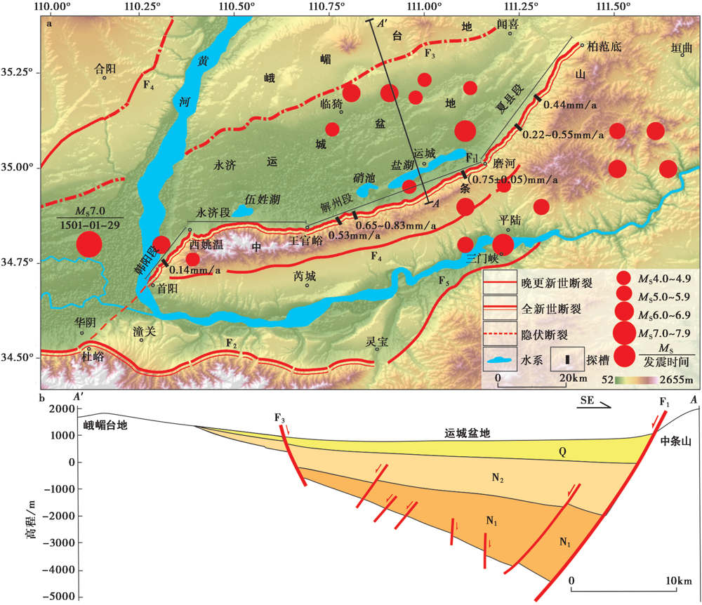
Fig. 1 Topographic and tectonic map of the Zhongtiao Mountains and adjacent basin areas.
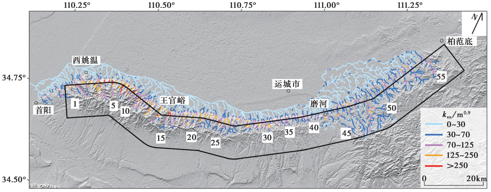
Fig. 2 Normalized steepness index ksn of the bedrock channels in the north flank of the Zhongtiao Mountains.
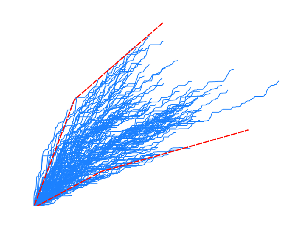
Fig. 3 χ-plot of the bedrock channels in the north flank of Zhongtiao Mountains.
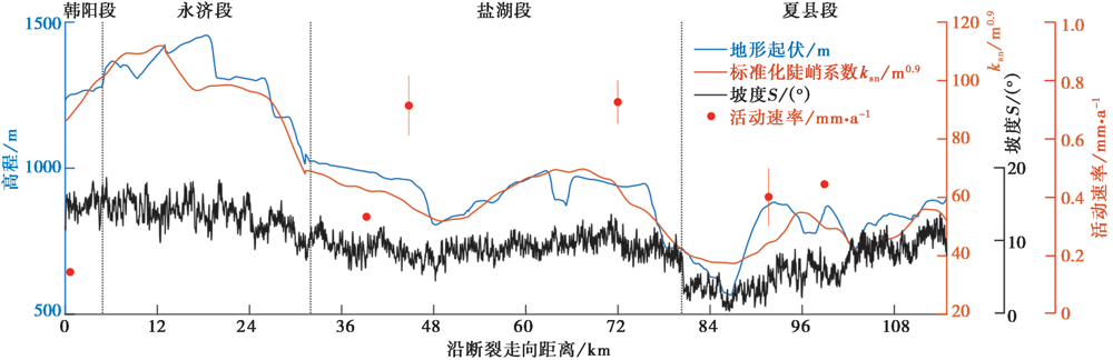
Fig. 4 Spatial distribution of relief, normalized steepness index ksn and slope along the north flank of Zhongtiao Mountains.
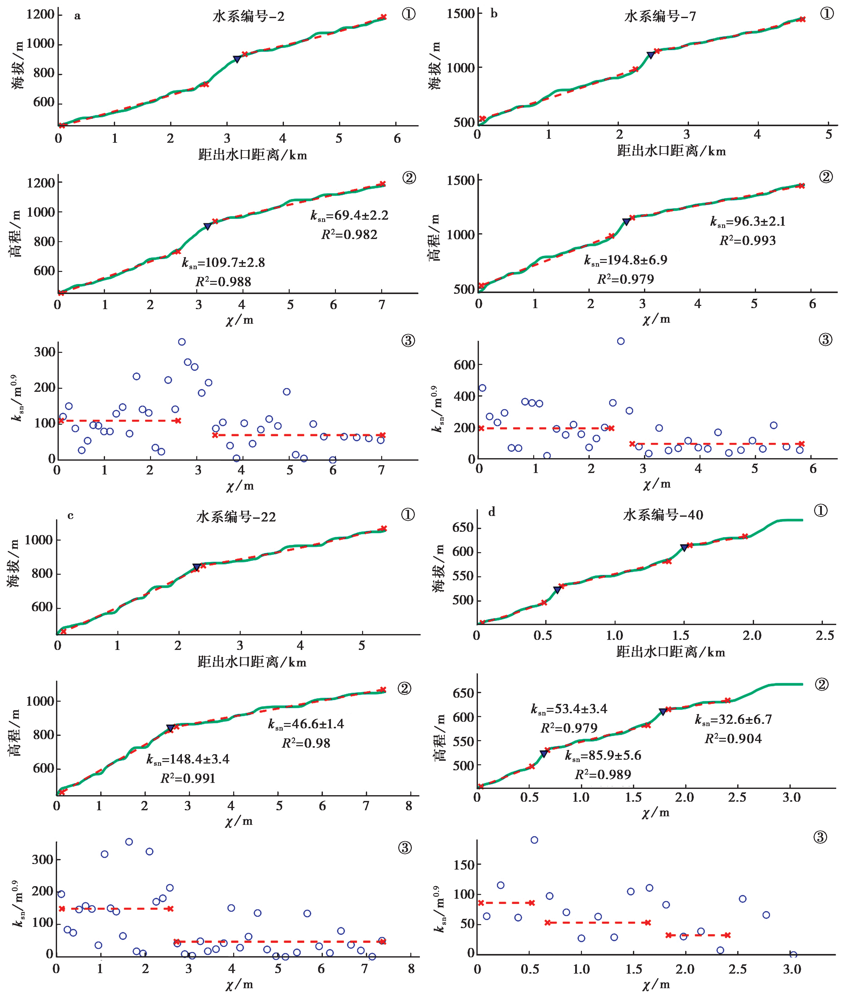
Fig. 5 Log-log analysis of longitudinal profiles and knickpoints.
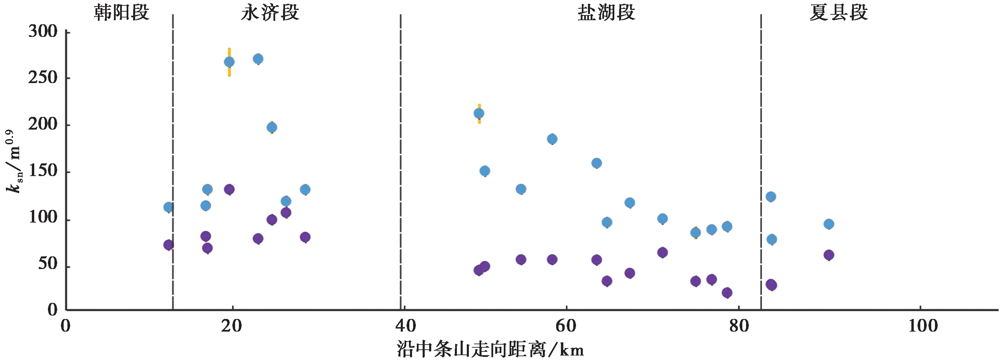
Fig. 6 The spatial distribution of normalized steepness index ksn in the upstream and downstream drainage areas of individual knickpoint.
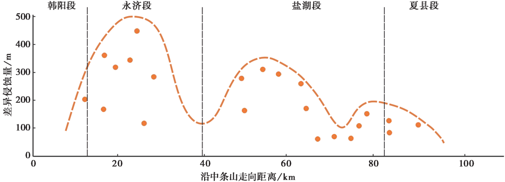
Fig. 7 Amount of fluvial incision along the north flank of Zhongtiao Mountains.
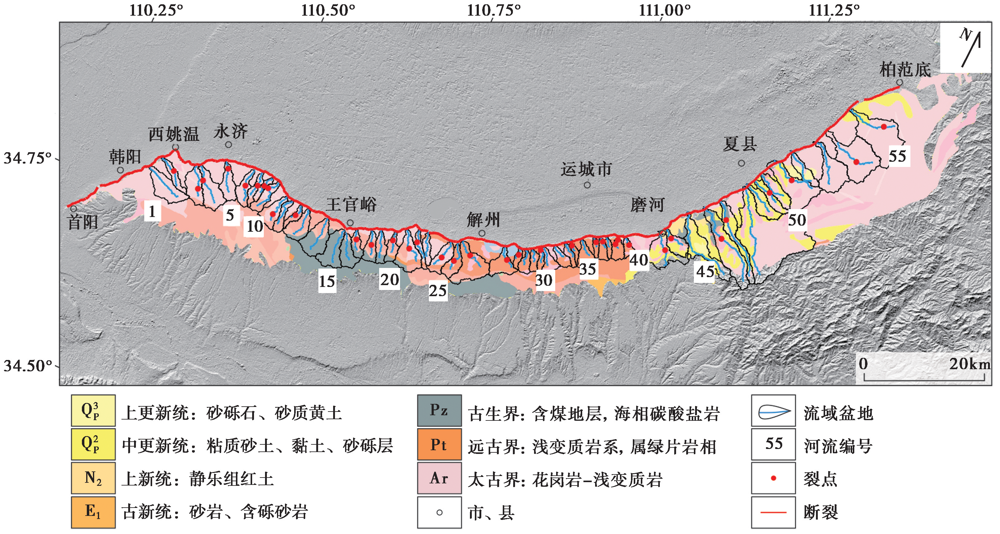
Fig. 8 Streams, position of knickpoints and lithological map of the Zhongtiao Mountains.
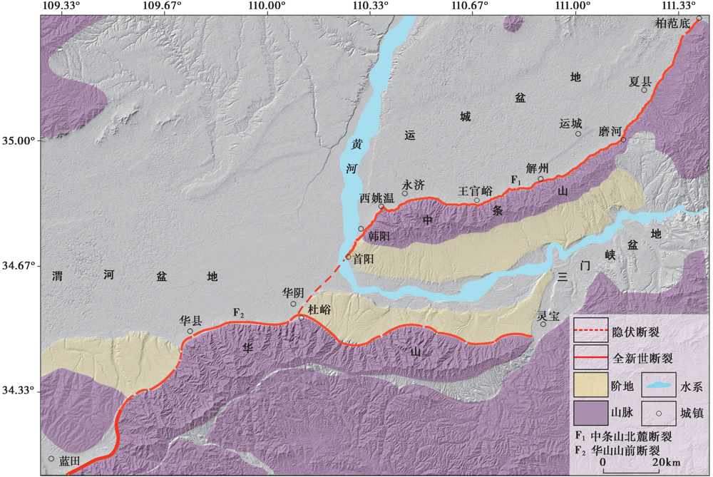
Fig. 9 Topographic and tectonic map of the Huashan Mountains and the Zhongtiao Mountains.
| [1] | 程绍平, 杨桂枝. 2002. 山西中条山断裂带的晚第四纪分段模型[J]. 地震地质, 24(3): 289-302. |
| CHENG Shao-ping, YANG Gui-zhi. 2002. Late Quaternary segmentation model of the Zhongtiaoshan Fault, Shanxi Province[J]. Seismology and Geology, 24(3): 289-302. (in Chinese) | |
| [2] | 慈洪娟, 闫冬冬, 李有利, 等. 2016. 中条山北麓韩阳段冲沟发育及其新构造意义[J]. 水土保持研究, 23(4): 363-367. |
| CI Hong-juan, YAN Dong-dong, LI You-li, et al. 2016. Geomorphic indices in the Hanyang segment of Zhongtiaoshan Mountains, Shanxi and its implication for neotectonics[J]. Research of Soil and Water Conservation, 23(4): 363-367. (in Chinese) | |
| [3] | 郭春杉. 2019. 运城盆地主要断裂活动性及其相关块体变形特征研究[D]. 北京: 中国地震局地震预测研究所. |
| GUO Chun-shan. 2019. Study on main fault activity and deformation characteristics of related blocks in Yuncheng Basin[D]. Institute of Earthquake Forecasting, CEA, Beijing. (in Chinese) | |
| [4] | 郭春杉, 李文巧, 田勤俭, 等. 2019. 中条山北麓断裂解州段晚更新世滑动速率研究[J]. 地震, 39(4): 13-26. |
| GUO Chun-shan, LI Wen-qiao, TIAN Qin-jian, et al. 2019. Study on late Pleistocene slip rate of Haizhou section of North Zhongtiaoshan Faults[J]. Earthquake, 39(4): 13-26. (in Chinese) | |
| [5] | 胡小飞, 潘保田, Kirby E, 等. 2010. 河道陡峭指数所反映的祁连山北翼抬升速率的东西差异[J]. 科学通报, 55(23): 2329-2338. |
|
HU Xiao-fei, PAN Bao-tian, Kirby E, et al. 2010. Spatial differences in rock uplift rates inferred from channel steepness indices along the northern flank of the Qilian Mountain, northeast Tibetan plateau[J]. Chinese Science Bulletin, 55(23): 2329-2338.
DOI URL |
|
| [6] | 马冀. 2019. 1556年华县M8?级地震地表破裂与发震构造[D]. 北京: 中国地震局地质研究所. |
| MA Ji. 2019. Surface rupture and its seismogenic faults of 1556 Huaxian M8?earthquake[D]. Institute of Geology, China Earthquake Administration, Beijing. (in Chinese) | |
| [7] |
苗德雨, 李有利, 吕胜华, 等. 2014. 山西中条山北麓断裂夏县段新构造运动[J]. 地理研究, 33(4): 665-673.
DOI |
|
MIAO De-yu, LI You-li, LÜ Sheng-hua, et al. 2014. Neotectonic activity in Xiaxian segment of the north Zhongtiao Mountain fault zone, Shanxi[J]. Geographical Research, 33(4): 665-673. (in Chinese)
DOI |
|
| [8] | 司苏沛, 李有利, 吕胜华, 等. 2014. 山西中条山北麓断裂盐池段全新世古地震事件和滑动速率研究[J]. 中国科学(D辑), 44(9): 1958-1967. |
| SI Su-pei, LI You-li, LÜ Sheng-hua, et al. 2014. Holocene paleoseismic events and slip rate of Yanchi section of the north foot fault of Zhongtiao Mountain in Shanxi, China[J]. Science in China(Ser D), 44(9): 1958-1967. (in Chinese) | |
| [9] | 田建梅, 李有利, 司苏沛, 等. 2013. 中条山北麓中段洪积扇上全新世断层陡坎的发现及其新构造意义[J]. 北京大学学报(自然科学版), 49(6): 986-992. |
| TIAN Jian-mei, LI You-li, SI Su-pei, et al. 2013. Discovery and neotectonic significance of fault scarps on alluvial fans in the middle of northern piedmont of the Zhongtiao Mountains[J]. Acta Scientiarum Naturalium Universitatis Pekinensis, 49(6): 986-992. (in Chinese) | |
| [10] | 王一舟, 张会平, 郑德文, 等. 2016. 基岩河道河流水力侵蚀模型及其应用: 兼论青藏高原基岩河道研究的迫切性[J]. 第四纪研究, 36(4): 884-897. |
| WANG Yi-zhou, ZHANG Hui-ping, ZHENG De-wen, et al. 2016. Stream-power incision model and its implications: Discussion on the urgency of studying bedrock channel across the Tibetan plateau[J]. Quaternary Sciences, 36(4): 884-897. (in Chinese) | |
| [11] |
徐伟, 杨源源, 袁兆德, 等. 2017. 华山山前断裂断错地貌及晚第四纪活动性[J]. 地震地质, 39(3): 587-604. doi: 10.3969/j.issn.0253-4967.2017.03.011.
DOI |
| XU Wei, YANG Yuan-yuan, YUAN Zhao-de, et al. 2017. Late Quaternary faulted landforms and fault activity of the Huashan piedmont fault[J]. Seismology and Geology, 39(3): 587-604. (in Chinese) | |
| [12] | 杨源源, 高战武, 徐伟. 2012. 华山山前断裂中段晚第四纪活动的地貌表现及响应[J]. 震灾防御技术, 7(4): 335-347. |
| YANG Yuan-yuan, GAO Zhan-wu, XU Wei. 2012. Geomorphic expression and response of the activity along the middle section of Huashan front fault in the late Quaternary period[J]. Technology for Earthquake Disaster Prevention, 7(4): 335-347. (in Chinese) | |
| [13] |
England P, Molnar P. 1990. Surface uplift, uplift of rocks, and exhumation of rocks[J]. Geology, 18(12): 1173-1177.
DOI URL |
| [14] |
Flint J J. 1974. Stream gradient as a function of order, magnitude, and discharge[J]. Water Resources Research, 10(5): 969-973.
DOI URL |
| [15] |
Fox M, Goren L, May D A, et al. 2015. Inversion of fluvial channels for paleorock uplift rates in Taiwan[J]. Journal of Geophysical Research: Earth Surface, 119(9): 1853-1875.
DOI URL |
| [16] |
Hijmans R J, Cameronse S E, Parra J L, et al. 2005. Very high resolution interpolated climate surfaces for global land areas[J]. International Journal of Climatology, 25(15): 1965-1978.
DOI URL |
| [17] |
Howard A D, Kerby G. 1983. Channel changes in badlands[J]. Geological Society of America Bulletin, 94(6): 739-752.
DOI URL |
| [18] |
Kirby E, Whipple K. 2001. Quantifying differential rock uplift rates via stream profile analysis[J]. Geology, 29(5): 415-418.
DOI URL |
| [19] |
Kirby E, Whipple K X. 2012. Expression of active tectonics in erosional landscapes[J]. Journal of Structural Geology, 44: 54-75.
DOI URL |
| [20] | Kirby E, Whipple K X, Tang W Q, et al. 2003. Distribution of active rock uplift along the eastern margin of the Tibetan plateau: Inferences from bedrock channel longitudinal profiles[J]. Journal of Geophysical Research: Solid Earth, 108(B4): 2217. |
| [21] |
Li D P, Du J J, Ma Y S, et al. 2015. Active faults and dip slip rates along the northern margins of the Huashan Mountain and Weinan loess tableland in the southeastern Weihe Graben, central China[J]. Journal of Asian Earth Sciences, 114(1): 266-278.
DOI URL |
| [22] | Oskin M, Perg L, Blumentritt D, et al. 2007. Slip rate of the Calico Fault: Implications for geologic versus geodetic rate discrepancy in the eastern California shear zone[J]. Journal of Geophysical Research: Solid Earth, 112(B7): B03402. |
| [23] |
Perron J T, Royden L. 2013. An integral approach to bedrock river profile analysis[J]. Earth Surface Processes and Landforms, 38(6): 570-576.
DOI URL |
| [24] | Snyder N P, Whipple K X, Tucker G E, et al. 2003. Importance of a stochastic distribution of floods and erosion thresholds in the bedrock river incision problem[J]. Journal of Geophysical Research: Solid Earth, 108(B2): 2117. |
| [25] | Stock J D, Montgomery D R. 1999. Geologic constraints on bedrock river incision using the stream power law[J]. Journal of Geophysical Research: Solid Earth, 104(B3): 4983-4993. |
| [26] | Su P, He H L, Tan X B, et al. 2021. Initiation and evolution of the Shanxi rift system in North China: Evidence from low-temperature thermochronology in a plate reconstruction framework[J]. Tectonics, 40(3): e2020TC006298. |
| [27] |
Su Q, Wang X Y, Lu H Y, et al. 2020. Dynamic divide migration as a response to asymmetric uplift: An example from the Zhongtiao Shan, North China[J]. Remote Sensing, 12(24): 4188.
DOI URL |
| [28] |
Whipple K X. 2001. Fluvial landscape response time: How plausible is steady-state denudation?[J]. American Journal of Science, 301(4-5): 313-325.
DOI URL |
| [29] | Whipple K X. 2004. Bedrock rivers and the geomorphology of active orogens[J]. Annual Review of Earth & Planetary Sciences, 32(1): 151-185. |
| [30] |
Whipple K X, Gasparini N M. 2014. Tectonic control of topography, rainfall patterns, and erosion during rapid post -12Ma uplift of the Bolivian Andes[J]. Lithosphere, 6(4): 251-268.
DOI URL |
| [31] | Whipple K X, Tucker G E. 1999. Dynamics of the stream-power river incision model: Implications for height limits of mountain ranges, landscape response timescales, and research needs[J]. Journal of Geophysical Research: Solid Earth, 104(B8): 17661-17674. |
| [32] | Wobus C W, Tucker G E, Anderson R S. 2006. Self-formed bedrock channels[J]. Geophysical Research Letters, 331(18): 273-274. |
| [33] |
Yang R, Willett S D, Goren L. 2015. In situ low-relief landscape formation as a result of river network disruption[J]. Nature, 520(7548): 526-529.
DOI URL |
| [1] | DENG Mo-Meng. CENOZOIC VOLCANISM AND TECTONIC EVOLUTION IN THE TIBETAN PLATEAU AND ITS ADJACENT AREAS [J]. SEISMOLOGY AND GEOLOGY, 2003, 25(s1): 51-61. |
| [2] | WANG Yu, LI Ji, MO Jing-Lin, LI Da-Meng. FORMATION AND DYNAMIC ANALYSIS OF NS TRENDING STRUCTURES IN SOUTHERN TIBET [J]. SEISMOLOGY AND GEOLOGY, 2000, 22(s1): 117-. |
| [3] | Cheng Guoliang, Li Yongan, Li Suling, Li Qiang, Zhang Hui. LATE PALEOZOIC PALEOMAGNETISM AND TECTONIC IMPLICATION FOR NORTHEAST JUNGGAR BLOCK, XINJIANG UYGUR AUTONOMOUS REGION, CHINA [J]. SEISMOLOGY AND GEOLOGY, 1993, 15(1): 32-44. |
| [4] | Peng Jianbing. TECTONIC EVOLUTION AND SEISMICITY OF WEIHE FAULT ZONE [J]. SEISMOLOGY AND GEOLOGY, 1992, 14(2): 113-120. |
| Viewed | ||||||
|
Full text |
|
|||||
|
Abstract |
|
|||||
