SEISMOLOGY AND GEOLOGY ›› 2022, Vol. 44 ›› Issue (5): 1128-1141.DOI: 10.3969/j.issn.0253-4967.2022.05.003
• Research paper • Previous Articles Next Articles
GUO Ming-rui1)( ), YU Hong-mei2),3)(), HU Jiu-chang1), WANG Xi-jiao1), ZHENG Zai-zhuang1), WANG Gui-dan1)
Received:2021-08-17
Revised:2022-05-05
Online:2022-10-20
Published:2022-11-28
Contact:
YU Hong-mei
郭明瑞1)(), 于红梅2),3),*(), 胡久常1), 王锡娇1), 郑在壮1), 王桂丹1)
通讯作者:
于红梅
作者简介:郭明瑞, 女, 1983年生, 工程师, 主要研究方向为火山地震监测与研究, 电话: 13648606197, E-mail: 545113937@qq.com。
基金资助:GUO Ming-rui, YU Hong-mei, HU Jiu-chang, WANG Xi-jiao, ZHENG Zai-zhuang, WANG Gui-dan. PROGRESS IN MONITORING AND RESEARCH OF ACTIVITY OF VOLCANOES IN NORTHERN HAINAN ISLAND[J]. SEISMOLOGY AND GEOLOGY, 2022, 44(5): 1128-1141.
郭明瑞, 于红梅, 胡久常, 王锡娇, 郑在壮, 王桂丹. 琼北火山监测与活动性研究进展[J]. 地震地质, 2022, 44(5): 1128-1141.
Add to citation manager EndNote|Ris|BibTeX
URL: https://www.dzdz.ac.cn/EN/10.3969/j.issn.0253-4967.2022.05.003
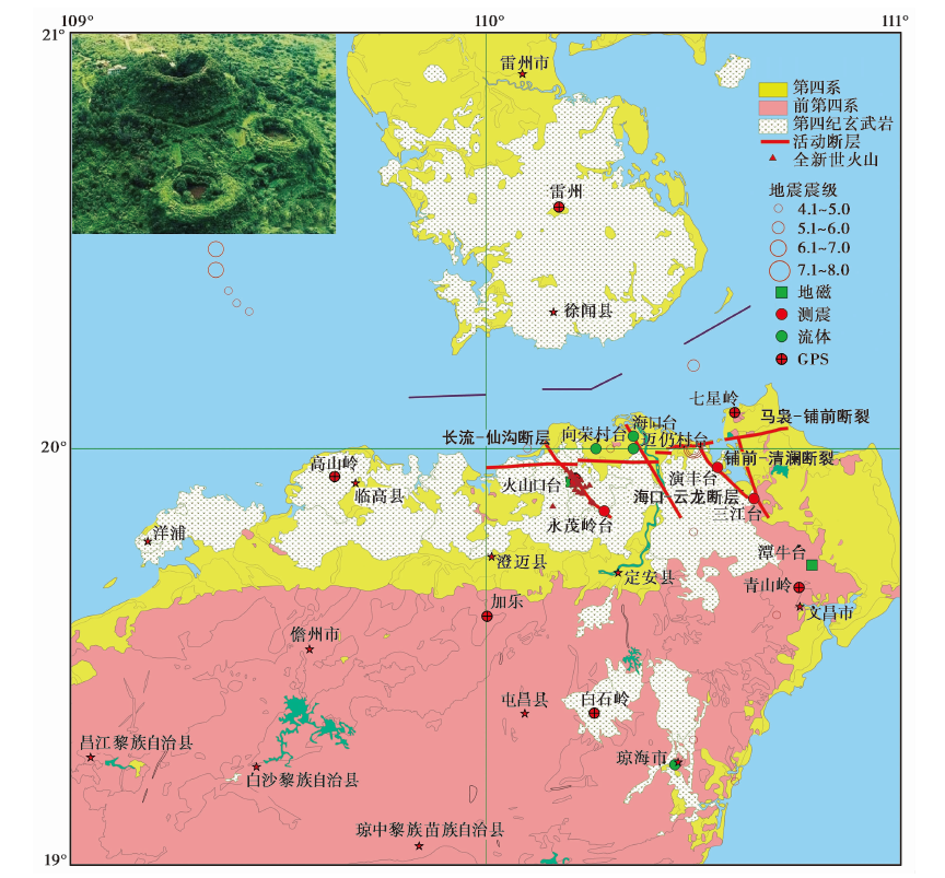
Fig. 1 Distribution of volcanoic rocks and monitoring means and equipment of volcanoes in northern Hainan Island.
| 期次始新世 | 喷发时代琼北坳陷区的澄迈福山盆地之中 | 分布范围34.78Ma | 喷发距今时间以3层玄武岩夹层的形式出露于与福山流沙港组湖相灰色泥岩和灰黄色砂砾岩之中。 | 岩性及特点1 |
|---|---|---|---|---|
| 2 | 渐新世 | 儋州木棠和文昌蓬莱地区 | 27.48Ma | 碱性橄榄玄武岩, 出露地表, 属琼北地区最早的地表火山岩。 |
| 3 | 中新世 | 琼北坳陷区 | 5.43~3.04Ma | 主要出露于地表, 火山岩性以碱性橄榄玄武岩、 碧玄岩为主, 含有大量橄榄岩包体及辉石巨晶。 |
| 4 | 上新世 | 琼北坳陷之中, 地表仅出露于海口金牛岭一带 | 3.82~3.13Ma | 火山岩性以石英拉斑玄武岩为主。 |
| 5 | 早更新世 屯昌期 | 定安岭口-黄竹及海口牛夏坡一带 | 2.3~0.99Ma | 火山岩性以碱性橄榄玄武岩、 玻基辉橄岩、 石英拉斑玄武岩、 火山角砾岩为主。 |
| 6 | 早更新世 琼山期 | 分布面积之广为琼北之最, 临高、 琼山、 文昌、 定安等 | 2.11~0.77Ma | 火山岩性主要包括石英拉斑玄武岩和橄榄拉斑玄武岩, 火山口附近则常出现少量碱性橄榄玄武岩。 |
| 7 | 中更新世 德义岭期 | 分布较广, 西起北部湾, 东至南渡江, 南到定安 | 0.73~0.21Ma | 岩性主要为石英拉斑玄武岩和橄榄拉斑玄武岩, 晚期出现碱性橄榄玄武岩。 |
| 8 | 晚更新世 道堂期 | 分布极广, 北自长流, 南至咸谅, 西起白莲 | 0.10~0.06Ma | 橄榄拉斑玄武岩和碱性橄榄玄武岩, 覆盖雷虎岭期玄武岩。 |
| 9 | 全新世 雷虎岭期 | 永兴-龙桥一带 | 9.91~10.27ka | 橄榄拉斑玄武岩和碱性橄榄玄武岩, 其上被全新世马鞍岭期玄武岩覆盖。 |
| 10 | 全新世 马鞍岭期 | 海口石山一带, 在马鞍岭出露最为典型和完好 | 8.155ka | 橄榄拉斑玄武岩和碱性橄榄玄武岩, 喷发不整合覆于全新世雷虎岭玄武岩之上, 其上无覆盖。 |
Table1 Eruption period and distribution range of volcanoes in northern Hainan Island (after BAI Zhi-da et al., 2003; WEI Hai-quan et al., 2003; DUAN Zheng et al., 2021)
| 期次始新世 | 喷发时代琼北坳陷区的澄迈福山盆地之中 | 分布范围34.78Ma | 喷发距今时间以3层玄武岩夹层的形式出露于与福山流沙港组湖相灰色泥岩和灰黄色砂砾岩之中。 | 岩性及特点1 |
|---|---|---|---|---|
| 2 | 渐新世 | 儋州木棠和文昌蓬莱地区 | 27.48Ma | 碱性橄榄玄武岩, 出露地表, 属琼北地区最早的地表火山岩。 |
| 3 | 中新世 | 琼北坳陷区 | 5.43~3.04Ma | 主要出露于地表, 火山岩性以碱性橄榄玄武岩、 碧玄岩为主, 含有大量橄榄岩包体及辉石巨晶。 |
| 4 | 上新世 | 琼北坳陷之中, 地表仅出露于海口金牛岭一带 | 3.82~3.13Ma | 火山岩性以石英拉斑玄武岩为主。 |
| 5 | 早更新世 屯昌期 | 定安岭口-黄竹及海口牛夏坡一带 | 2.3~0.99Ma | 火山岩性以碱性橄榄玄武岩、 玻基辉橄岩、 石英拉斑玄武岩、 火山角砾岩为主。 |
| 6 | 早更新世 琼山期 | 分布面积之广为琼北之最, 临高、 琼山、 文昌、 定安等 | 2.11~0.77Ma | 火山岩性主要包括石英拉斑玄武岩和橄榄拉斑玄武岩, 火山口附近则常出现少量碱性橄榄玄武岩。 |
| 7 | 中更新世 德义岭期 | 分布较广, 西起北部湾, 东至南渡江, 南到定安 | 0.73~0.21Ma | 岩性主要为石英拉斑玄武岩和橄榄拉斑玄武岩, 晚期出现碱性橄榄玄武岩。 |
| 8 | 晚更新世 道堂期 | 分布极广, 北自长流, 南至咸谅, 西起白莲 | 0.10~0.06Ma | 橄榄拉斑玄武岩和碱性橄榄玄武岩, 覆盖雷虎岭期玄武岩。 |
| 9 | 全新世 雷虎岭期 | 永兴-龙桥一带 | 9.91~10.27ka | 橄榄拉斑玄武岩和碱性橄榄玄武岩, 其上被全新世马鞍岭期玄武岩覆盖。 |
| 10 | 全新世 马鞍岭期 | 海口石山一带, 在马鞍岭出露最为典型和完好 | 8.155ka | 橄榄拉斑玄武岩和碱性橄榄玄武岩, 喷发不整合覆于全新世雷虎岭玄武岩之上, 其上无覆盖。 |
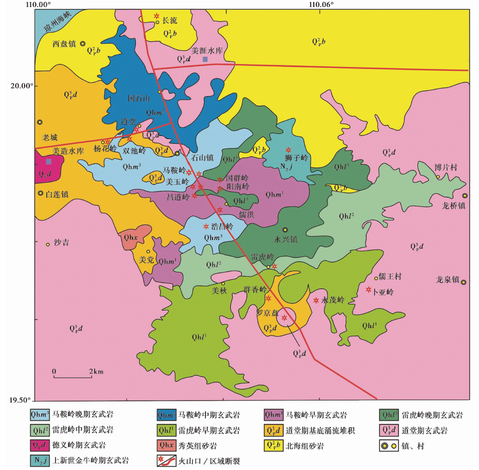
Fig. 2 Geological sketch map of northern Hainan (after BAI Zhi-da et al., 2003; WEI Hai-quan et al., 2003; DUAN Zheng et al., 2021).
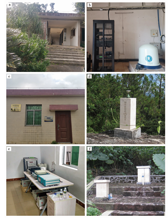
Fig. 3 The monitoring network of Qiongbei volcanic area.
| 台站名称 | 高程/m | 仪器 | 型号 | 采样率/Hz | 仪器安装日期 |
|---|---|---|---|---|---|
| 三江台 | 10 | 宽频带地震计 | BBVS-60 | 100 | 2005-06-17 |
| 数据采集器 | EDAS-24IP | 100 | |||
| 马鞍岭台 | 161 | 宽频带地震计 | BBVS-60 | 100 | 2006-02-25 |
| 数据采集器 | EDAS-24IP | 100 | |||
| 永茂台 | 54 | 宽频带地震计 | BBVS-60 | 100 | 2006-11-15 |
| 数据采集器 | EDAS-24IP | 100 | |||
| 演丰台 | 129 | 宽频带地震计 | BBVS-60 | 100 | 2007-03-08 |
| 数据采集器 | EDAS-24IP | 100 |
Table2 Qiongbei volcano seismic network information sheet
| 台站名称 | 高程/m | 仪器 | 型号 | 采样率/Hz | 仪器安装日期 |
|---|---|---|---|---|---|
| 三江台 | 10 | 宽频带地震计 | BBVS-60 | 100 | 2005-06-17 |
| 数据采集器 | EDAS-24IP | 100 | |||
| 马鞍岭台 | 161 | 宽频带地震计 | BBVS-60 | 100 | 2006-02-25 |
| 数据采集器 | EDAS-24IP | 100 | |||
| 永茂台 | 54 | 宽频带地震计 | BBVS-60 | 100 | 2006-11-15 |
| 数据采集器 | EDAS-24IP | 100 | |||
| 演丰台 | 129 | 宽频带地震计 | BBVS-60 | 100 | 2007-03-08 |
| 数据采集器 | EDAS-24IP | 100 |
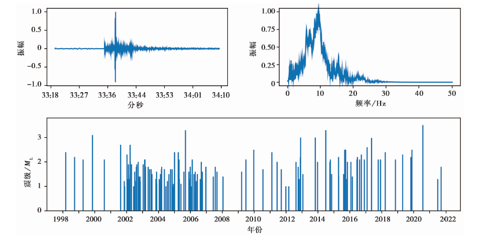
Fig. 4 Epicenter distribution of earthquakes in the volcanic area from 1998 to 2021.
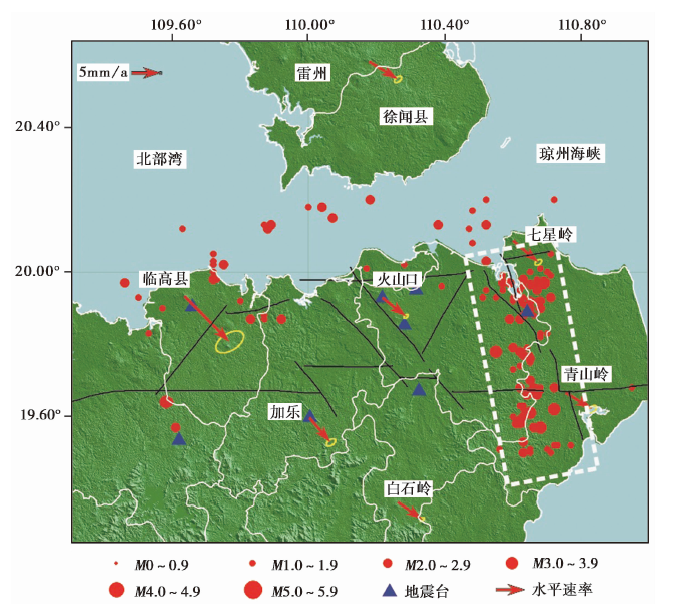
Fig. 5 Horizontal vectors of GNSS sites movement in northern Hainan area relative to the Eurasian Plate (2009-2018) and earthquakes of the volcano area.
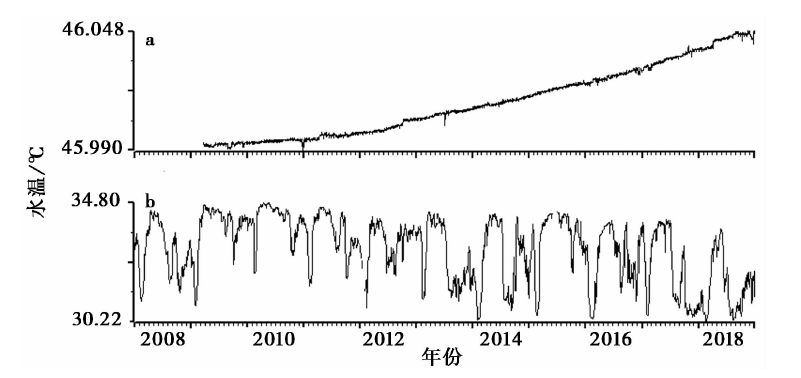
Fig. 6 Annual dynamic curve of water temperature of the Haikou well(a)and volcano well(b).
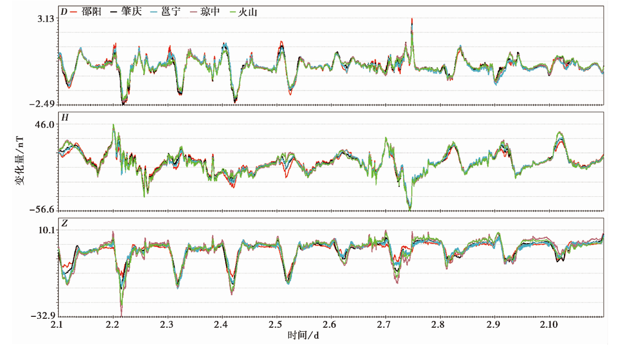
Fig. 7 Comparison of magnetic observatin curves between the volcano station and the reference station.
| [1] |
白志达, 徐德斌, 魏海泉, 等. 2003. 琼北马鞍岭地区第四纪火山活动期次划分[J]. 地震地质, 25(S1): 12-20.
|
|
|
|
| [2] |
段政, 张翔, 周翠, 等. 2021. 琼北地区第四纪火山地质遗迹类型与地学意义[J]. 地球学报, 42(1): 111-123.
|
|
|
|
| [3] |
樊祺诚, 孙谦, 李霓, 等. 2004. 琼北火山活动分期与全新世岩浆演化[J]. 岩石学报, 20(3): 533-544.
|
|
|
|
| [4] |
洪汉净. 2006. “琼北火山探查及喷发危险性研究”项目成果介绍[J]. 国际地震动态, (9): 32-34.
|
|
|
|
| [5] |
胡久常, 白登海, 王薇华, 等. 2007. 雷琼火山区地下深部大地电磁探测与电性结构分析[J]. 华南地震, 27(1): 1-7.
|
|
|
|
| [6] |
DOI |
|
|
|
| [7] |
胡亚轩, 郝明, 秦姗兰, 等. 2018. 海南岛现今三维地壳运动与断裂活动性研究[J]. 地球物理学报, 61(6): 2310-2321.
|
|
|
|
| [8] |
刘辉, 洪汉净, 冉洪流, 等. 2008. 琼北火山群形成的动力学机制及地震现象的新认识[J]. 地球物理学报, 51(6): 1804-1809.
|
|
|
|
| [9] |
刘嘉麒. 1999. 中国火山[M]. 北京: 科学出版社.
|
|
|
|
| [10] |
刘若新. 2000. 中国的活火山[M]. 北京: 地震出版社.
|
|
|
|
| [11] |
孙翔宇, 詹艳, 赵国泽, 等. 2020. 琼东北马鞍岭-雷虎岭火山区深部岩浆系统大地电磁三维探测[J]. 地震地质, 42(3): 640-653. doi: 10.3969/j.0253-4967.2020.03.007.
DOI |
|
|
|
| [12] |
魏海泉, 白志达, 胡久常, 等. 2003. 琼北全新世火山区火山系统的划分与锥体结构参数研究[J]. 地震地质, 25(S1): 21-32.
|
|
|
|
| [13] |
吴建平, 明跃红, 刘一鸣, 等. 2003. 2002年8月20日长白山天池火山小震震群研究[J]. 地震地磁观测与研究, 24(4): 1-8.
|
|
|
|
| [14] |
许建东. 2017. 火山灾害与火山喷发预测预警[J]. 城市与灾害, 1(1): 11-15.
|
|
|
|
| [15] |
曾小苹, 续春荣, 赵明, 等. 1996. 地球磁场对太阳风的加载响应与地震[J]. 地震地磁观测与研究, 17(1): 49-53.
|
|
|
|
| [16] |
詹文欢, 朱照宇, 姚衍桃, 等. 2006. 南海西北部珊瑚礁记录所反映的新构造运动[J]. 第四纪研究, 26(1): 77-84.
|
|
|
|
| [17] |
张新东, 王晓山, 沈繁銮, 等. 2013. 由现今小震资料研究琼北地区区域应力场和发震构造[J]. 地震学报, 35(4): 451-460.
|
|
|
|
| [18] |
DOI URL |
| [19] |
|
| [1] | ZHOU Yao-ming, ZHU Wen-bin, CHEN Zheng-le, ZHU Bing-yu, XUE Feng. THE INTERPRETATION OF GRAVITATIONAL AND MAGNETIC DATA FOR THE VOLCANIC ROCKS DISTRIBUTION IN KE-BAI FAULT ZONE, JUNGGAR BASIN [J]. SEISMOLOGY AND GEOLOGY, 2018, 40(3): 641-655. |
| [2] | ZHENG Jian-chang, QU Li, QU Jun-hao, HU Xu-hui, LI Dong-mei. comparison of locations of rushan earthquake swarm from large and small network [J]. SEISMOLOGY AND GEOLOGY, 2015, 37(4): 953-965. |
| [3] | ZOU Zhen-xuan, LI Jun, ZHOU Xin-min, WANG Zheng, LI Jin-long. BODY WAVE TRAVELTIME TOMOGRAPHY FOR ZHEJIANG DIGITAL SEISMIC NETWORK [J]. SEISMOLOGY AND GEOLOGY, 2013, 35(4): 864-872. |
| [4] | ZHAO Xiao-yun, LI Zi-hong, YAN Xiao-bing, BO Jian-jie, LI Hui-ling, GAO Yun-feng. SEISMIC DISASTER ASSESSMENT AND PREDICTION BASED ON HISTORICAL MATERIALS OF TWO STRONG EARTHQUAKES IN LINFEN REGION AND GIS TECHNOLOGY [J]. SEISMOLOGY AND GEOLOGY, 2011, 33(3): 568-576. |
| [5] | HU Jiu-chang, GUO Ming-rui, LIU Wei, ZHENG Zai-zhuang. PRIMARY RESEARCH ON THE VOLCANIC ACTIVITY IN HAIKOU AREA [J]. SEISMOLOGY AND GEOLOGY, 2009, 31(4): 647-654. |
| [6] | JI Ling-yun, XU Jian-dong, LIN Xu-dong, LUAN Peng. APPLICATION OF SATELLITE THERMAL INFRARED REMOTE SENSING IN MONITORING CHANGBAISHAN TIANCHI VOLCANO ACTIVITY [J]. SEISMOLOGY AND GEOLOGY, 2009, 31(4): 617-627. |
| [7] | XU Jian-dong, ZHOU Ben-gang, WEI Hai-quan, ZHAO Bo, PAN Bo, LUAN Peng. SOME DISCUSSIONS ON DETERMINATION OF THE LAST ACTIVE TIME OF FAULTS IN AREAS WITH QUATERNARY VOLCANIC ACTIVITY [J]. SEISMOLOGY AND GEOLOGY, 2008, 30(2): 553-561. |
| [8] | L? Zheng, YANG Qing-fu, ZHANG Heng-rong, LIU Guo-ming, GAO Jin-zhe. STUDY OF THE RELATIONSHIP BETWEEN CHANGBAISHAN TIANCHI VOLCANIC SEISMIC ACTIVITY AND DEEP EARTHQUAKES IN THE NORTHWEST PACIFIC SUBDUCTION ZONE [J]. SEISMOLOGY AND EGOLOGY, 2007, 29(3): 470-479. |
| [9] | HONG Han-jing, WU Jian-ping, WANG Qing-liang, LI Ke, ZHAO Ci-ping, SHANGGUAN Zhi-guan, YANG Qing-fu, ZHANG Heng-rong, LIU Guo-ming. VOLCANIC THREAT LEVELS AND CLASSIFICATION OF VOLCANIC ACTIVITY IN CHINA [J]. SEISMOLOGY AND EGOLOGY, 2007, 29(3): 447-458. |
| [10] | DENG Mo-Meng. CENOZOIC VOLCANISM AND TECTONIC EVOLUTION IN THE TIBETAN PLATEAU AND ITS ADJACENT AREAS [J]. SEISMOLOGY AND GEOLOGY, 2003, 25(s1): 51-61. |
| [11] | GUO Biao, LIU Qi-yuan, CHEN Jiu-hui, LI Shun-cheng. TEST OF EPICENTER DETERMINATION OF MICROEARTHQUAKES RECORDED BY THE DIGITAL SEISMIC NETWORK IN CAPITAL CIRCLE [J]. SEISMOLOGY AND GEOLOGY, 2002, 24(3): 453-460. |
| Viewed | ||||||
|
Full text |
|
|||||
|
Abstract |
|
|||||
