SEISMOLOGY AND GEOLOGY ›› 2022, Vol. 44 ›› Issue (5): 1290-1312.DOI: 10.3969/j.issn.0253-4967.2022.05.013
• Research paper • Previous Articles Next Articles
SONG Ting1),2)( ), SHEN Xu-zhang3)(), MEI Xiu-ping2),4), JIAO Yu-yuan2),4), LI Min-juan2),4), SU Xiao-yun2),4), JI Wan-jing2),4)
Received:2021-07-12
Revised:2022-02-22
Online:2022-10-20
Published:2022-11-28
Contact:
SHEN Xu-zhang
宋婷1),2)(), 沈旭章3),*(), 梅秀苹2),4), 焦煜媛2),4), 李敏娟2),4), 苏小芸2),4), 季婉婧2),4)
通讯作者:
沈旭章
作者简介:宋婷, 女, 1990年生, 2020年于中国地震局兰州地震研究所获固体地球物理学硕士学位, 工程师, 主要研究方向为地震学, E-mail: songtingseis@163.com。
基金资助:SONG Ting, SHEN Xu-zhang, MEI Xiu-ping, JIAO Yu-yuan, LI Min-juan, SU Xiao-yun, JI Wan-jing. CONSTRAINING MOHO CHARACTERISTICS IN THE NORTH-EASTERN MARGIN OF TIBET PLATEAU WITH FREQUENCY-DEPENDENCE OF RECEIVER FUNCTION[J]. SEISMOLOGY AND GEOLOGY, 2022, 44(5): 1290-1312.
宋婷, 沈旭章, 梅秀苹, 焦煜媛, 李敏娟, 苏小芸, 季婉婧. 利用接收函数频率特征研究青藏高原东北缘地区的莫霍面性质[J]. 地震地质, 2022, 44(5): 1290-1312.
Add to citation manager EndNote|Ris|BibTeX
URL: https://www.dzdz.ac.cn/EN/10.3969/j.issn.0253-4967.2022.05.013
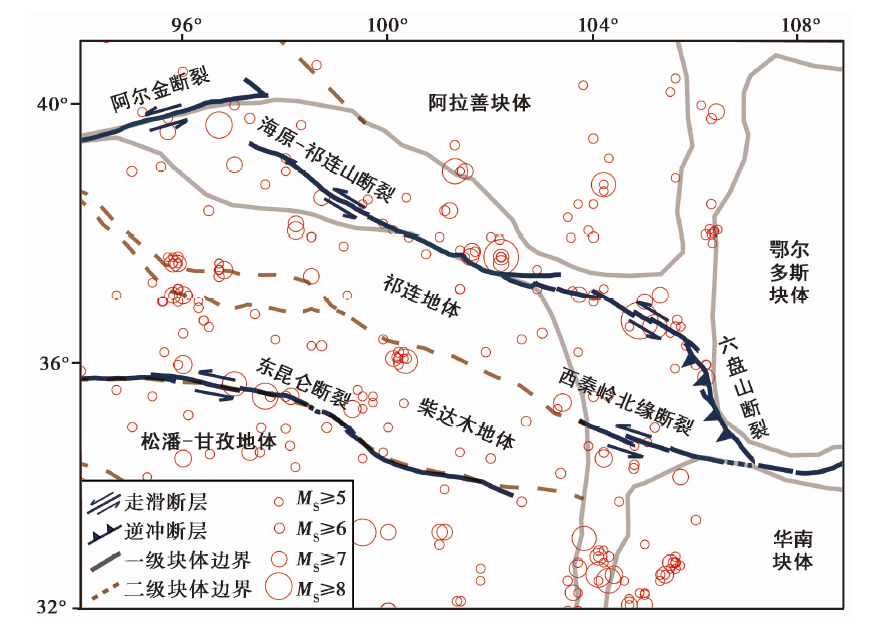
Fig. 1 Map of the tectonic features and seismicity of the study area(since 1900).
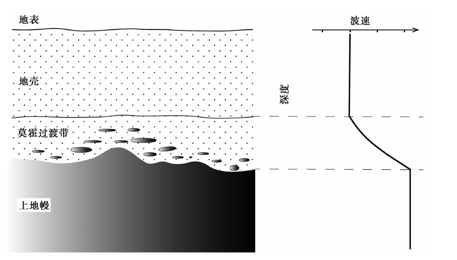
Fig. 2 Sketch showing the forming of Moho transition zone.
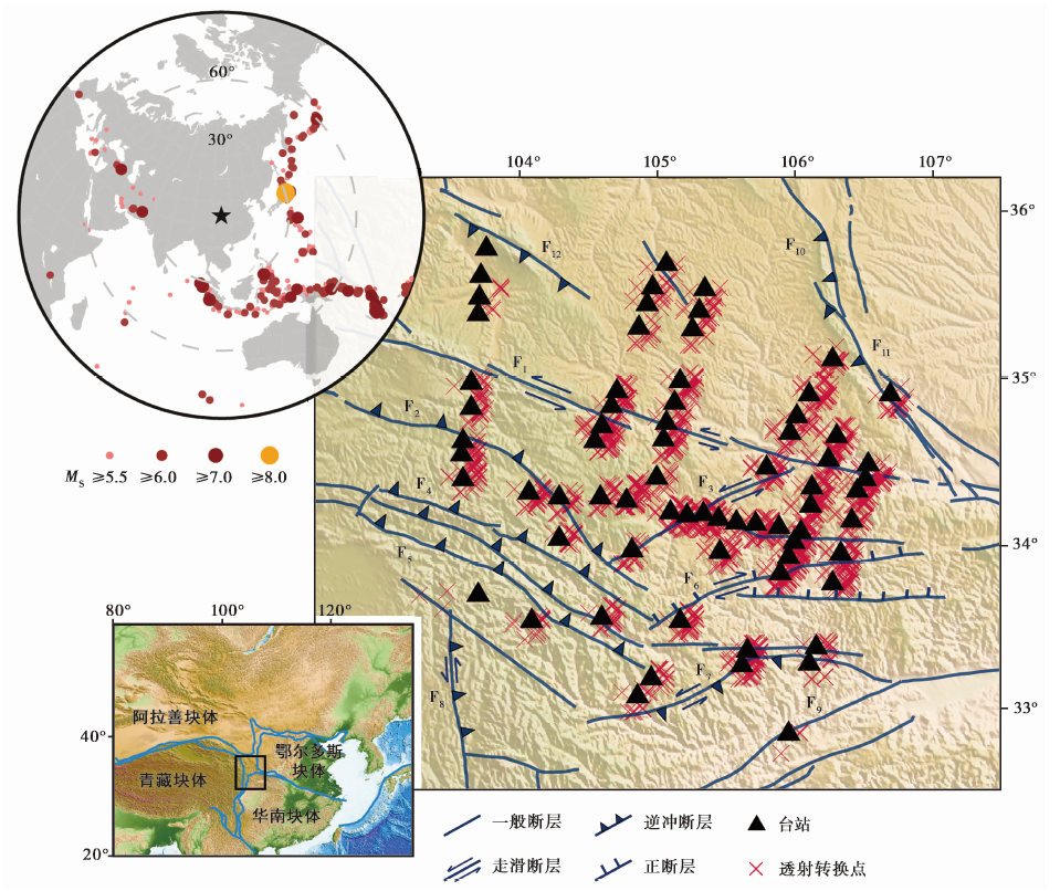
Fig. 3 Map of the seismic arrays and epicenters.
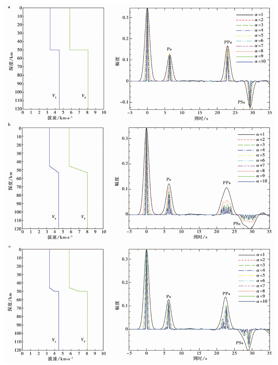
Fig. 4 Velocity model with different Moho transition(left panels)and corresponding synthetic frequency-dependence of receiver functions(right panels).
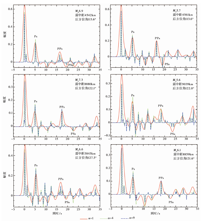
Fig. 5 Frequency-dependence of receiver functions for station S309.
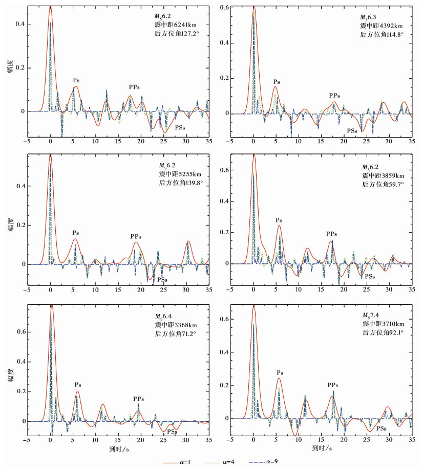
Fig. 6 Frequency-dependence of receiver functions for station S609.
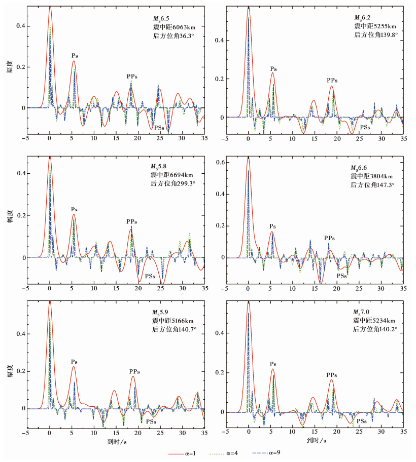
Fig. 7 Frequency-dependence of receiver functions for station S422.
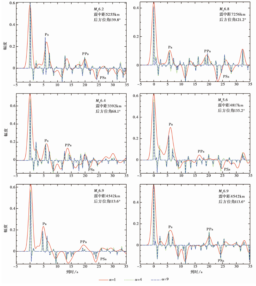
Fig. 8 Frequency-dependence of receiver functions for station S318.
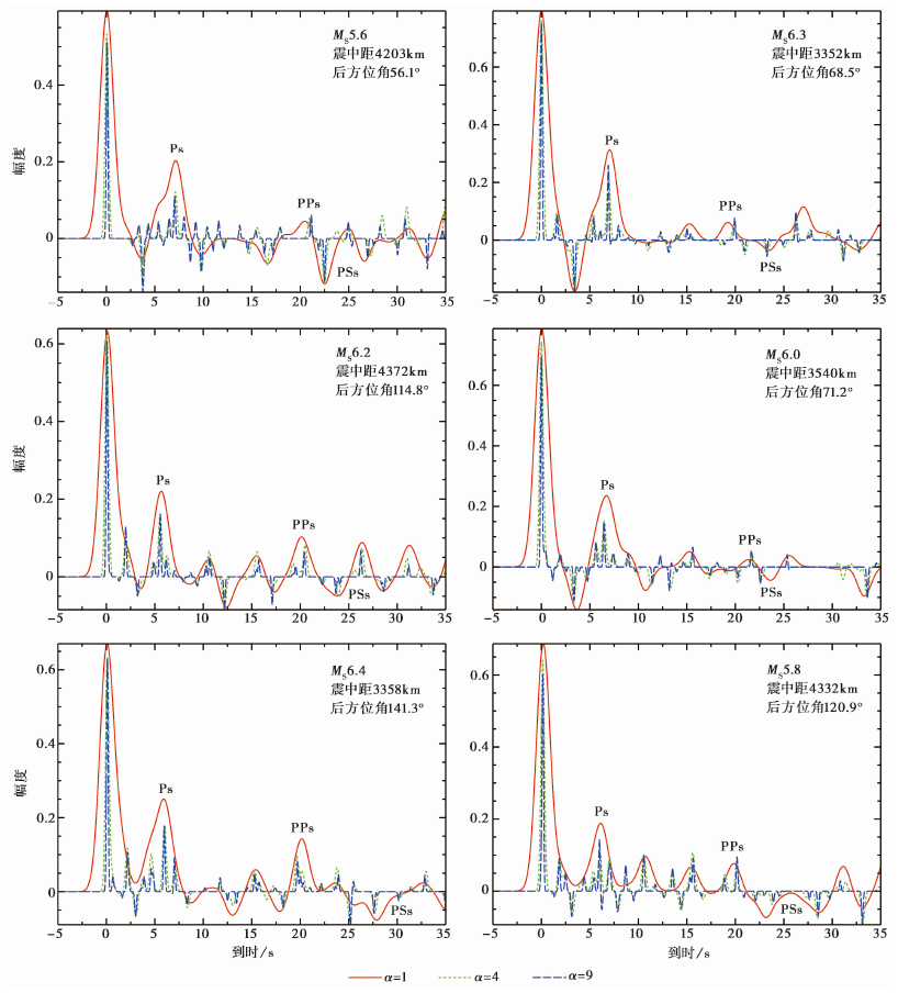
Fig. 9 Frequency-dependence of receiver functions for station S108.
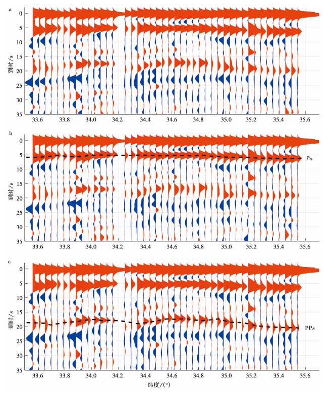
Fig. 10 Stacked of receiver functions along profile L3 based on the location of piercing points.
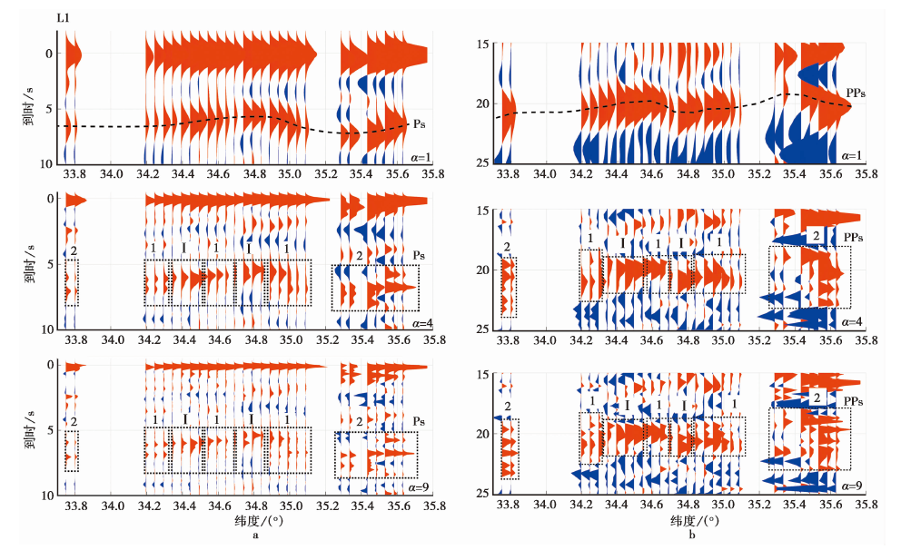
Fig. 11 Frequency-dependence of Ps and PPs receiver functions for profile L1.
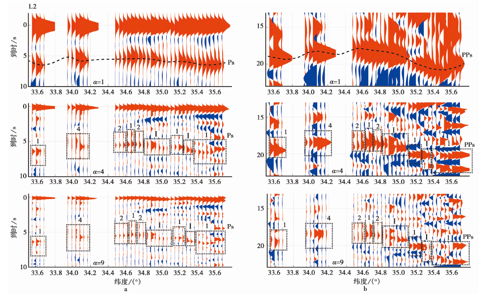
Fig. 12 Frequency-dependence of Ps and PPs receiver functions for profile L2.
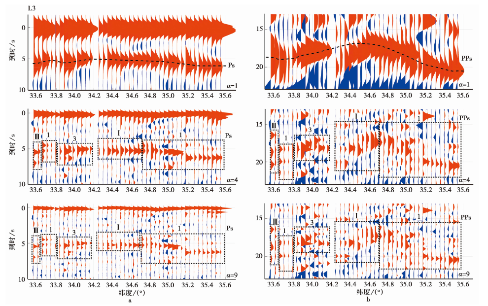
Fig. 13 Frequency-dependence of Ps and PPs receiver functions for profile L3.
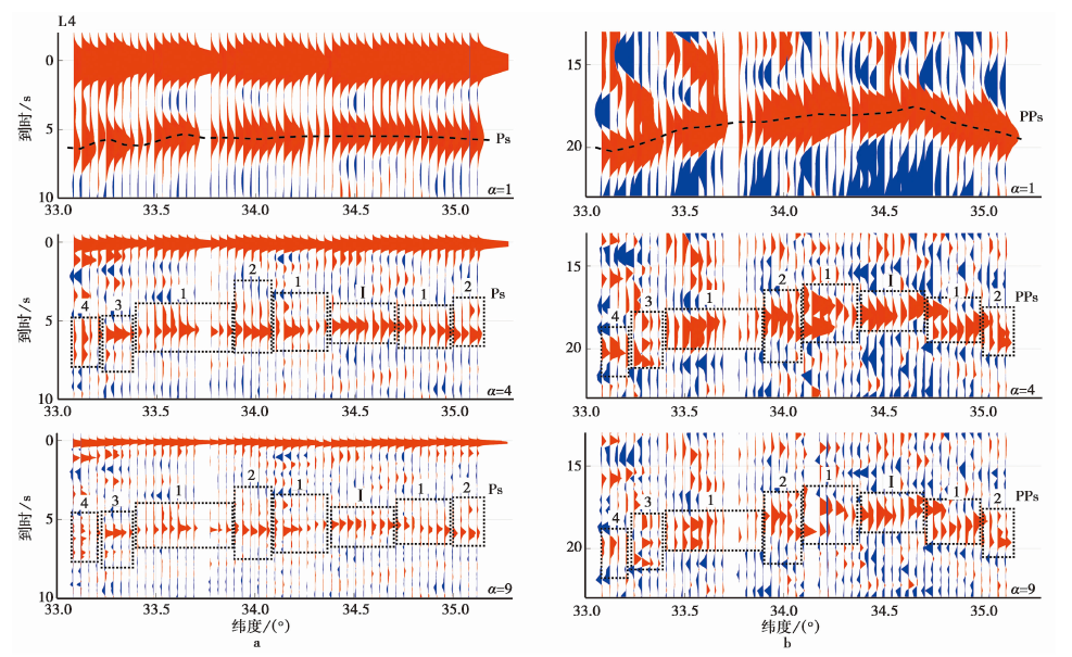
Fig. 14 Frequency-dependence of Ps and PPs receiver functions for profile L4.
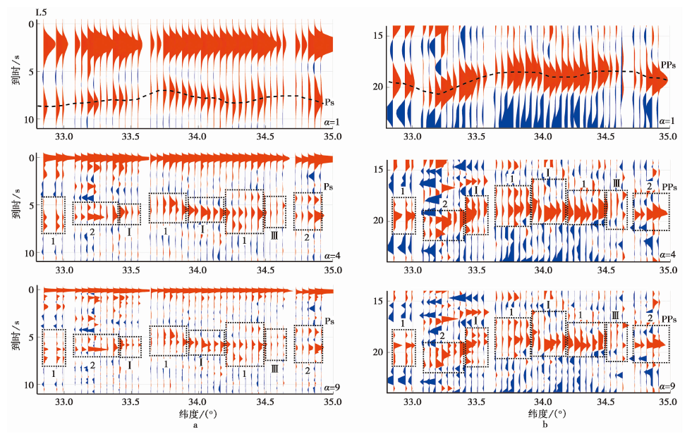
Fig. 15 Frequency-dependence of Ps and PPs receiver functions for profile L5.
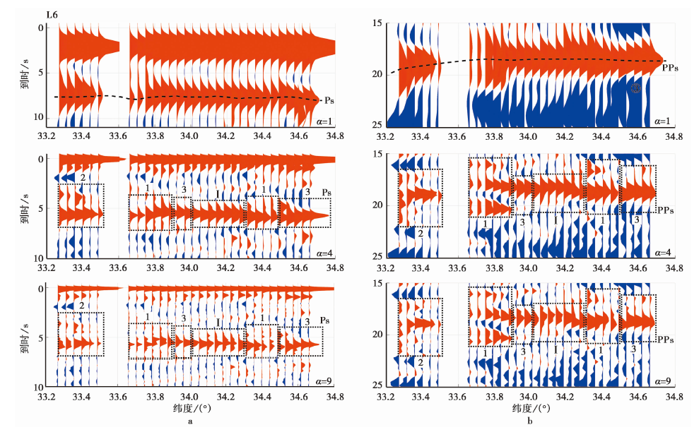
Fig. 16 Frequency-dependence of Ps and PPs receiver functions for profile L6.
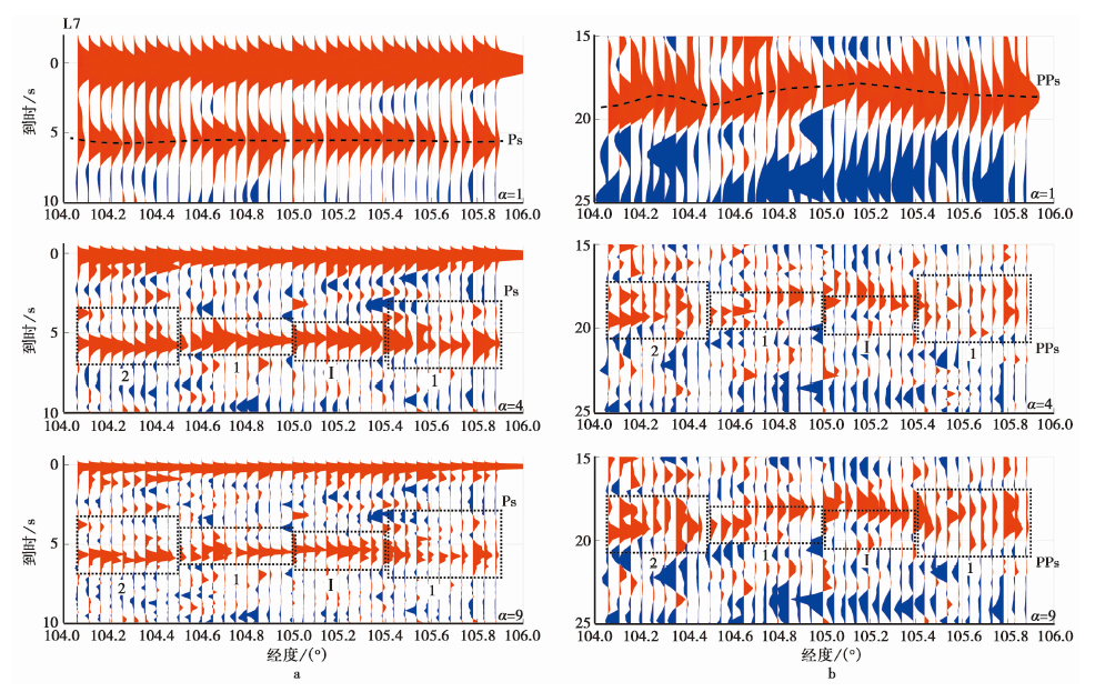
Fig. 17 Frequency-dependence of Ps and PPs receiver functions for profile L7.
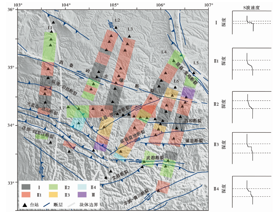
Fig. 18 Frequency-dependence of receiver functions of the study area.
| [1] |
陈九辉, 刘启元, 李顺成, 等. 2005. 青藏高原东北缘-鄂尔多斯地块地壳上地幔S波速度结构[J]. 地球物理学报, 48(2): 333-342.
|
|
|
|
| [2] |
陈鹏. 2016. 西秦岭地区晚新生代构造演化: 以天水盆地为例[D]. 北京: 中国地质科学院.
|
|
|
|
| [3] |
赖晓玲, 李松林, 张先康, 等. 2001. 玛沁-兰州-靖边剖面壳幔复杂性的研究[J]. 地球物理学进展, 16(2): 65-72.
|
|
|
|
| [4] |
赖晓玲, 张先康, 成双喜, 等. 2004a. 张家口-渤海断裂带西缘壳幔过渡带研究[J]. 地球物理学报, 47(5): 798-804.
|
|
|
|
| [5] |
赖晓玲, 张先康, 方盛明. 2004b. 青藏高原东北缘壳幔过渡带研究[J]. 地震学报, 26(2): 132-139.
|
|
|
|
| [6] |
李敏娟, 沈旭章, 张元生, 等. 2018. 基于密集台阵的青藏高原东北缘地壳精细结构及九寨沟地震震源区结构特征分析[J]. 地球物理学报, 61(5): 2075-2087.
|
|
|
|
| [7] |
李少华, 王彦宾, 梁子斌, 等. 2012. 甘肃东南部地壳速度结构的区域地震波形反演[J]. 地球物理学报, 55(4): 1186-1197.
|
|
|
|
| [8] |
李英康, 高锐, 高建伟, 等. 2015. 秦岭造山带的EW向地壳速度结构特征[J]. 地球物理学进展, 30(3): 1056-1069.
|
|
|
|
| [9] |
李永华, 吴庆举, 田小波, 等. 2009. 用接收函数方法研究云南及其邻区地壳上地幔结构[J]. 地球物理学报, 52(1): 67-80.
|
|
|
|
| [10] |
刘明军. 2007. 青藏高原东北缘地壳结构、 组成与动力学[D]. 北京: 中国地震局地球物理研究所.
|
|
|
|
| [11] |
刘明军, 李松林, 方盛明, 等. 2008. 利用地震波速研究青藏高原东北缘地壳组成及其动力学[J]. 地球物理学报, 51(2): 412-430.
|
|
|
|
| [12] |
刘启元,
|
|
|
|
| [13] |
刘启元, 邵学钟. 1985. 天然地震Ps转换波动力学特征的初步研究[J]. 地球物理学报, 28(3): 291-302.
|
|
|
|
| [14] |
邵若潼, 沈旭章, 张元生. 2019. 青藏高原东北缘甘东南地区地壳各向异性特征及构造意义[J]. 地球物理学报, 62(9): 3340-3353.
|
|
|
|
| [15] |
宋婷, 沈旭章, 梅秀苹. 2020. 利用接收函数频率特征研究莫霍面形态及应用[J]. 地震学报, 42(2): 135-150.
|
|
|
|
| [16] |
滕吉文. 2006. 地球深部壳-幔边界的层束精细结构与物理属性研究[J]. 吉林大学学报(地球科学版), 36(1): 1-23.
|
|
|
|
| [17] |
王椿镛, 楼海, 吕智勇, 等. 2008. 青藏高原东部地壳上地幔S波速度结构: 下地壳流的深部环境[J]. 中国科学(D辑), 38(1): 22-32.
|
|
|
|
| [18] |
危自根, 储日升, 陈凌, 等. 2016. 复杂地壳接收函数H-κ叠加: 以安纳托利亚板块为例[J]. 地球物理学报, 59(11): 4048-4062.
|
|
|
|
| [19] |
熊小松. 2010. 中国大陆Moho面深度与变化特征及其地球动力学意义[D]. 北京: 中国地质科学院.
|
|
|
|
| [20] |
张洪双, 高锐, 田小波, 等. 2015. 青藏高原东北缘地壳S波速度结构及其动力学含义: 远震接收函数提供的证据[J]. 地球物理学报, 58(11): 3982-3992.
|
|
|
|
| [21] |
张先康, 嘉世旭, 赵金仁, 等. 2008. 西秦岭-东昆仑及邻近地区地壳结构: 深地震宽角反射/折射剖面结果[J]. 地球物理学报, 51(2): 439-450.
|
|
|
|
| [22] |
赵俊猛, 刘国栋, 卢造勋, 等. 2001. 天山造山带与准噶尔盆地壳幔过渡带及其动力学含义[J]. 中国科学(D辑), 31(4): 272-282.
|
|
|
|
| [23] |
赵俊猛, 张先康, 赵国泽, 等. 1999. 不同构造环境下的壳-幔过渡带结构[J]. 地学前缘, 6(3): 165-172.
|
|
|
|
| [24] |
DOI URL |
| [25] |
DOI URL |
| [26] |
|
| [27] |
DOI URL |
| [28] |
DOI URL |
| [29] |
|
| [30] |
DOI URL |
| [31] |
DOI URL |
| [32] |
DOI URL |
| [33] |
DOI URL |
| [34] |
PMID |
| [35] |
DOI URL |
| [36] |
DOI URL |
| [37] |
|
| [38] |
DOI URL |
| [39] |
|
| [40] |
DOI URL |
| [41] |
DOI |
| [42] |
|
| [43] |
|
| [1] | YANG Jian-wen, JIN Ming-pei, CHA Wen-jian, ZHANG Tian-ji, YE Beng. CRUSTAL S-WAVE VELOCITY STRUCTURE BENEATH THE XIAO-JIANG FAULT ZONE AND ADJACENT REGIONS REVEALED BY TWO-STEP INVERSION METHOD OF RECEIVER FUNCTIONS [J]. SEISMOLOGY AND GEOLOGY, 2023, 45(1): 190-207. |
| [2] | PAN Ji-shun, LI Peng-hui, DUAN Yong-hong, ZHAO Yan-na, PENG Yi-cong, SUN Kai-xuan. STUDY ON THE CRUSTAL STRUCTURE OF THE CENTRAL AND WESTERN PART OF THE NORTH CHINA CRATON [J]. SEISMOLOGY AND EGOLOGY, 2021, 43(5): 1269-1291. |
| [3] | GAO Jian, YANG Yi-hai, HUANG Shi-yuan, YANG Cong, ZHANG Yuan-sheng, LIU Cun-xi, LI Shao-rui, HUA Qian. CRUSTAL ANISOTROPY AND ITS TECTONIC IMPLICATIONS IN THE CHONGQING REGION [J]. SEISMOLOGY AND GEOLOGY, 2020, 42(1): 147-162. |
| [4] | TANG Ming-shuai, WANG Hai-tao, WEI Yun-yun, LI Yan-yong, GE Can, WANG Qiong, SU Jin-bo, WEI Bin. POISSON'S RATIO VARIATIONS OF CRUSTAL MEDIA BEFORE AND AFTER XINYUAN-HEJING MS6.6 EARTHQUAKE IN 2012 [J]. SEISMOLOGY AND GEOLOGY, 2019, 41(5): 1123-1135. |
| [5] | WANG Lin, ZHOU Qing-yun, WANG Jun, LI Wen-qiao, ZHOU Lian-qing, CHEN Han-lin, SU Peng, LIANG Peng. THE RESEARCH OF THE SEISMOGENIC STRUCTURE OF THE LUSHAN EARTHQUAKE BASED ON THE SYNTHESIS OF THE DEEP SEISMIC DATA AND THE SURFACE TECTONIC DEFORMATION [J]. SEISMOLOGY AND GEOLOGY, 2016, 38(2): 458-476. |
| [6] | LI Yong-hua, XU Xiao-ming, ZHANG En-hui, GAO Jia-yi. THREE-DIMENSIONAL CRUST STRUCTURE BENEATH SE TIBETAN PLATEAU AND ITS SEISMOTECTONIC IMPLICATIONS FOR THE LUDIAN AND JINGGU EARTHQUAKES [J]. SEISMOLOGY AND GEOLOGY, 2014, 36(4): 1204-1216. |
| [7] | HONG De-quan, WANG Xing-zhou, LI Jun-hui, NI Si-dao. STUDY ON THE CRUSTAL THICKNESS BENEATH STATIONS OF SEISMIC NETWORK IN ANHUI PROVINCE BY TELESEISMIC RECEIVER FUNCTION [J]. SEISMOLOGY AND GEOLOGY, 2013, 35(4): 853-863. |
| [8] | WANG Xiao-long, MA Sheng-li, LEI Xing-lin, GUO Xin, WANG Qiang, YU Guo-zheng, GOU Xian-bin, KUWAHARA Yasuto, IMANISHI Kazutoshi, JIANG Xia-dong. FINE VELOCITY STRUCTURE AND RELOCATION OF THE 2010 ML5.1 EARTHQUAKE SEQUENCE IN RONGCHANG GAS FIELD [J]. SEISMOLOGY AND GEOLOGY, 2012, (2): 348-358. |
| [9] | TANG Xin-gong, YOU Shuang-shuang, HU Wen-bao, YAN Liang-jun. THE CRUSTAL DENSITY STRUCTURE UNDERNEATH LONGMENSHAN FAULT ZONE [J]. SEISMOLOGY AND GEOLOGY, 2012, 34(1): 28-38. |
| [10] | WANG Xiao-long, NI Si-dao, LIU Yuan-yuan, YU Guo-zheng, LI Ke-chang. STUDY OF CRUSTAL THICKNESS VARIATION IN CHONGQING SECTION OF THREE GORGES RESERVOIR AREA FROM TELESEISMIC RECEIVER FUNCTION METHOD [J]. SEISMOLOGY AND GEOLOGY, 2010, 32(4): 543-551. |
| [11] | JIA Li-hua, CHONG Jia-jun, LIU Yuan-yuan, NI Si-dao, DAI Jin, WANG Shuai. CRUSTAL THICKNESS AND POISSON RATIO OF LIAONING PROVINCE FROM RECEIVER FUNCTION STUDY [J]. SEISMOLOGY AND EGOLOGY, 2010, 32(2): 260-268. |
| [12] | LI Hai-ou, XU Xi-wei, JIANG Mei, MA Wen-tao. CRUSTAL STRUCTURE UNDER BANGONG-NUJIANG SUTURE AND TERRAIN ASSEMBLY MODEL OF LHASA AND QIANGTANG BLOCKS IN THE WESTERN QINGHAI-TIBET PLATEAU [J]. SEISMOLOGY AND GEOLOGY, 2010, 32(2): 213-221. |
| [13] | WU Jian-ping, MING Yue-hong, SU Wei, FANG Li-hua, WANG Wei-Lai. S-WAVE VELOCITY STRUCTURE BENEATH CHANGBAISHAN TIANCHI VOLCANO INFERRED FROM RECEIVER FUNCTION [J]. SEISMOLOGY AND GEOLOGY, 2009, 31(4): 584-597. |
| [14] | QI Shao-hua, LIU Qi-yuan, CHEN Jiu-hui, LI Yu, LI Shun-cheng, Guo Biao, WANG Jun. WENCHUAN EARTHQUAKE MS 8.0:PRELIMINARY STUDY OF CRUSTAL ANISOTROPY ON BOTH SIDES OF THE LONGMENSHAN FAULTS [J]. SEISMOLOGY AND GEOLOGY, 2009, 31(3): 377-388. |
| [15] | LIU Chun, CHONG Jia-jun, NI Si-dao, LI Shao-rui. STUDY ON THE CRUSTAL THICKNESS BENEATH STATIONS OF SEISMIC NETWORK IN SHAANXI PROVINCE BY TELESEISMIC RECEIVER FUNCTION [J]. SEISMOLOGY AND GEOLOGY, 2009, 31(2): 313-320. |
| Viewed | ||||||
|
Full text |
|
|||||
|
Abstract |
|
|||||
