SEISMOLOGY AND GEOLOGY ›› 2022, Vol. 44 ›› Issue (6): 1421-1447.DOI: 10.3969/j.issn.0253-4967.2022.06.005
• Research paper • Previous Articles Next Articles
LI Zhao1,2)( ), FU Bi-hong1),*()
Received:2021-12-05
Revised:2022-02-27
Online:2022-12-20
Published:2023-01-21
Contact:
FU Bi-hong
李昭1,2)(), 付碧宏1),*()
通讯作者:
付碧宏
作者简介:李昭, 女, 1996年生, 2022年于中国科学院空天信息创新研究院获地图学与地理信息系统专业硕士学位, 主要研究方向为资源与环境遥感、 活动构造与构造地貌学, E-mail: lizhao@aircas.ac.cn。
基金资助:CLC Number:
LI Zhao, FU Bi-hong. QUANTITATIVE ANALYSES OF GEOMORPHOLOGIC FEATURES IN RESPONSE TO LATE QUATERNARY TECTONIC ACTI-VITIES ALONG THE MAQIN-MAQU SEGMENT, EAST KUNLUN FAULT ZONE[J]. SEISMOLOGY AND GEOLOGY, 2022, 44(6): 1421-1447.
李昭, 付碧宏. 东昆仑断裂带玛沁-玛曲段晚第四纪构造活动特征的地貌响应定量研究[J]. 地震地质, 2022, 44(6): 1421-1447.
Add to citation manager EndNote|Ris|BibTeX
URL: https://www.dzdz.ac.cn/EN/10.3969/j.issn.0253-4967.2022.06.005

Fig. 1 Map showing major active faults developed along the Maqin-Maqu segment of the East Kunlun fault zone (modified from DENG Qi-dong, 2002 and Fu et al., 2011).

Fig. 2 Geologic map of the Maqin-Maqu segment in the East Kunlun fault zone.
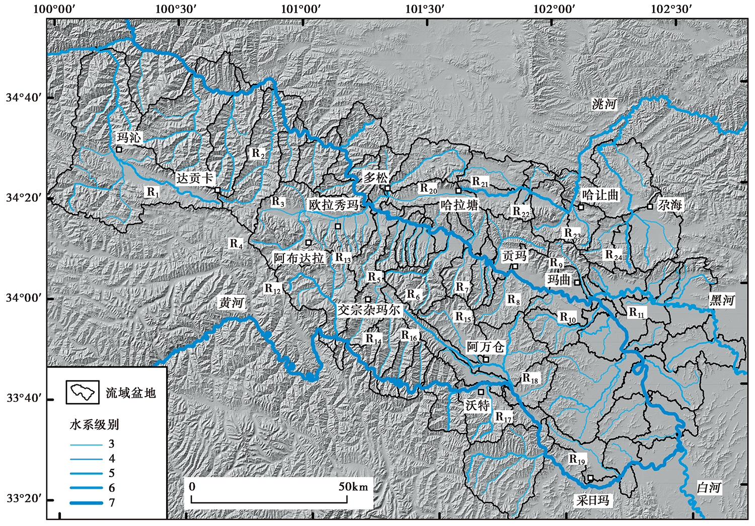
Fig. 3 River system grading and drainage basins distribution map along the Maqin-Maqu segment in the East Kunlun fault zone.
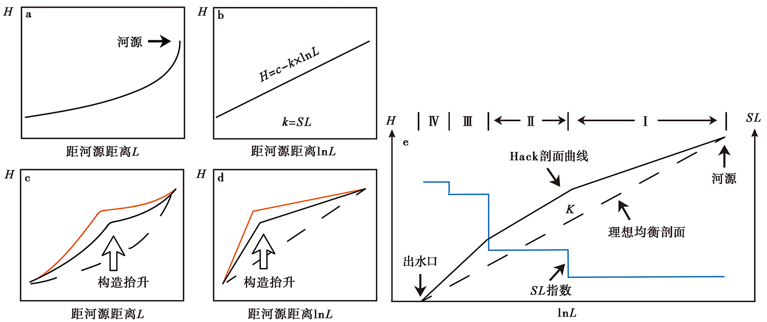
Fig. 4 Conceptual diagram of Hack profiles(modified from Chen et al., 2003).
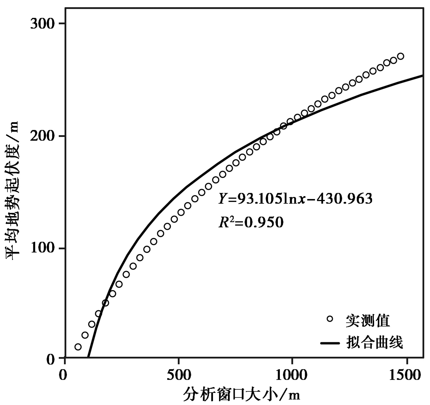
Fig. 5 Relationship between statistics units and topographic relief(30m).

Fig. 6 HI map of the Maqin-Maqu segment in the East Kunlun fault zone.
| 断裂带名称 | 分段 | 河流编号 | 河长/km | 均衡坡降指数K | Kmean |
|---|---|---|---|---|---|
| 玛沁—玛曲段 主断裂带 | 玛沁—欧拉秀玛段(西段) | R1 | 109.05 | 97.43 | 95.30 |
| R2 | 69.00 | 99.90 | |||
| R3 | 59.70 | 82.66 | |||
| R4 | 37.95 | 101.19 | |||
欧拉秀玛—贡玛段(中段) | R5 | 36.30 | 82.67 | 77.47 | |
| R6 | 40.20 | 89.67 | |||
| R7 | 22.95 | 71.06 | |||
| R8 | 26.25 | 66.49 | |||
玛曲段(东段) | R9 | 29.85 | 60.95 | 32.67 | |
| R10 | 42.75 | 30.57 | |||
| R11 | 14.70 | 6.50 | |||
| 阿万仓断裂 | 阿布达拉段(北西段) | R4 | 37.95 | 101.19 | 74.15 |
| R12 | 46.80 | 73.94 | |||
| R13 | 21.00 | 47.33 | |||
交宗杂玛尔—沃特段(中段) | R14 | 41.55 | 60.86 | 62.62 | |
| R15 | 66.45 | 75.83 | |||
| R16 | 39.00 | 51.19 | |||
沃特—采日玛段(南东段) | R17 | 29.40 | 41.52 | 33.22 | |
| R18 | 24.45 | 42.98 | |||
| R19 | 43.50 | 15.17 | |||
| 尕海断裂 | 多松段(西段) | R20 | 37.60 | 40.25 | 40.25 |
哈拉塘—哈让曲段(中段) | R21 | 74.10 | 65.45 | 55.47 | |
| R22 | 13.35 | 54.11 | |||
| R23 | 19.95 | 46.86 | |||
| 尕海段(东段) | R24 | 91.80 | 50.83 | 50.83 |
Table1 The river geomorphic parameters of the Maqin-Maqu segment in the East Kunlun fault zone
| 断裂带名称 | 分段 | 河流编号 | 河长/km | 均衡坡降指数K | Kmean |
|---|---|---|---|---|---|
| 玛沁—玛曲段 主断裂带 | 玛沁—欧拉秀玛段(西段) | R1 | 109.05 | 97.43 | 95.30 |
| R2 | 69.00 | 99.90 | |||
| R3 | 59.70 | 82.66 | |||
| R4 | 37.95 | 101.19 | |||
欧拉秀玛—贡玛段(中段) | R5 | 36.30 | 82.67 | 77.47 | |
| R6 | 40.20 | 89.67 | |||
| R7 | 22.95 | 71.06 | |||
| R8 | 26.25 | 66.49 | |||
玛曲段(东段) | R9 | 29.85 | 60.95 | 32.67 | |
| R10 | 42.75 | 30.57 | |||
| R11 | 14.70 | 6.50 | |||
| 阿万仓断裂 | 阿布达拉段(北西段) | R4 | 37.95 | 101.19 | 74.15 |
| R12 | 46.80 | 73.94 | |||
| R13 | 21.00 | 47.33 | |||
交宗杂玛尔—沃特段(中段) | R14 | 41.55 | 60.86 | 62.62 | |
| R15 | 66.45 | 75.83 | |||
| R16 | 39.00 | 51.19 | |||
沃特—采日玛段(南东段) | R17 | 29.40 | 41.52 | 33.22 | |
| R18 | 24.45 | 42.98 | |||
| R19 | 43.50 | 15.17 | |||
| 尕海断裂 | 多松段(西段) | R20 | 37.60 | 40.25 | 40.25 |
哈拉塘—哈让曲段(中段) | R21 | 74.10 | 65.45 | 55.47 | |
| R22 | 13.35 | 54.11 | |||
| R23 | 19.95 | 46.86 | |||
| 尕海段(东段) | R24 | 91.80 | 50.83 | 50.83 |
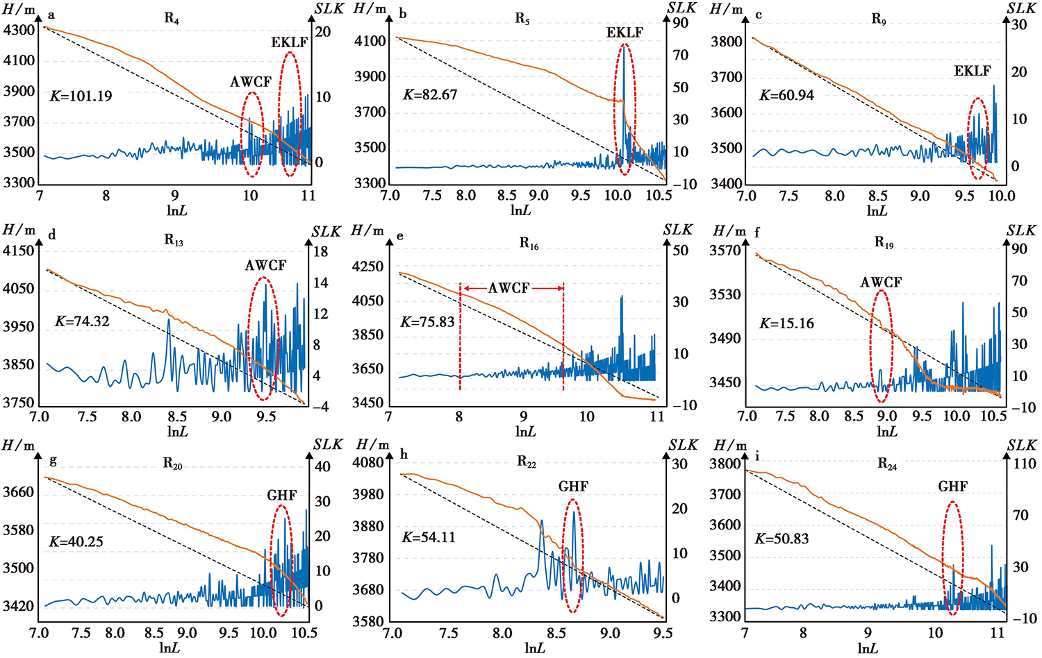
Fig. 7 Hack profile and SLK index along the Maqin-Maqu segment in the East Kunlun fault zone.
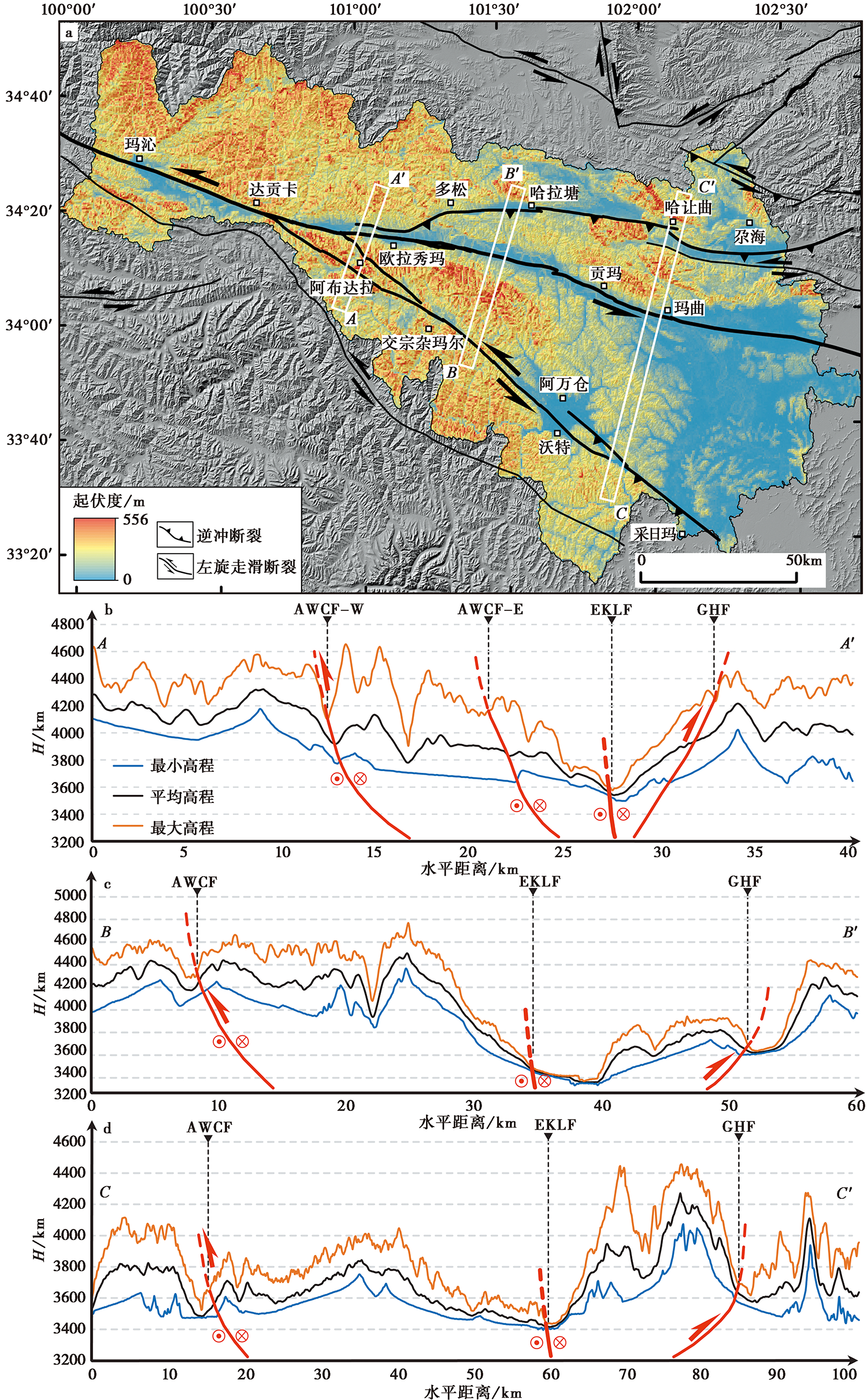
Fig. 8 Topographic relief map of the Maqin-Maqu segment in the East Kunlun fault zone.
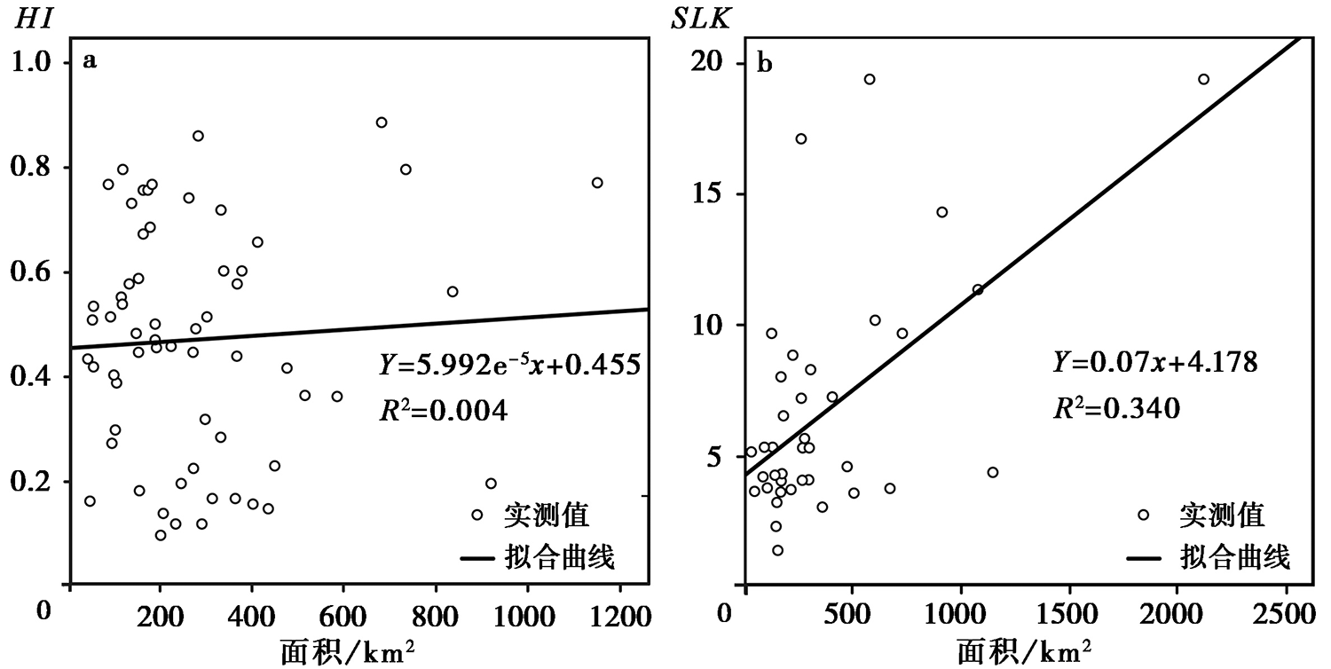
Fig. 9 Correlation analysis between geomorphic index(HI, SLK) and basin area of the Maqin-Maqu segment in the East Kunlun fault zone.

Fig. 10 Correlation analysis between HI and lithology of the Maqin-Maqu segment in the East Kunlun fault zone.
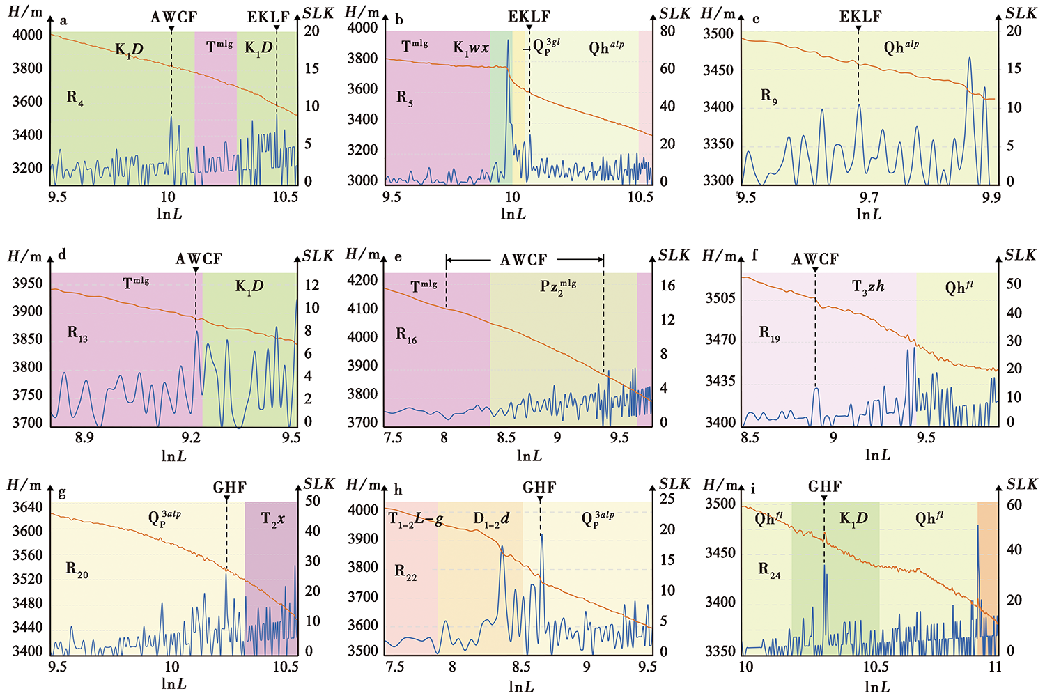
Fig. 11 Correlation analysis between SLK and lithology of the Maqin-Maqu segment in the East Kunlun fault zone.

Fig. 12 Tectono-geomorpgic characteristics along the Maqin-Maqu segment.
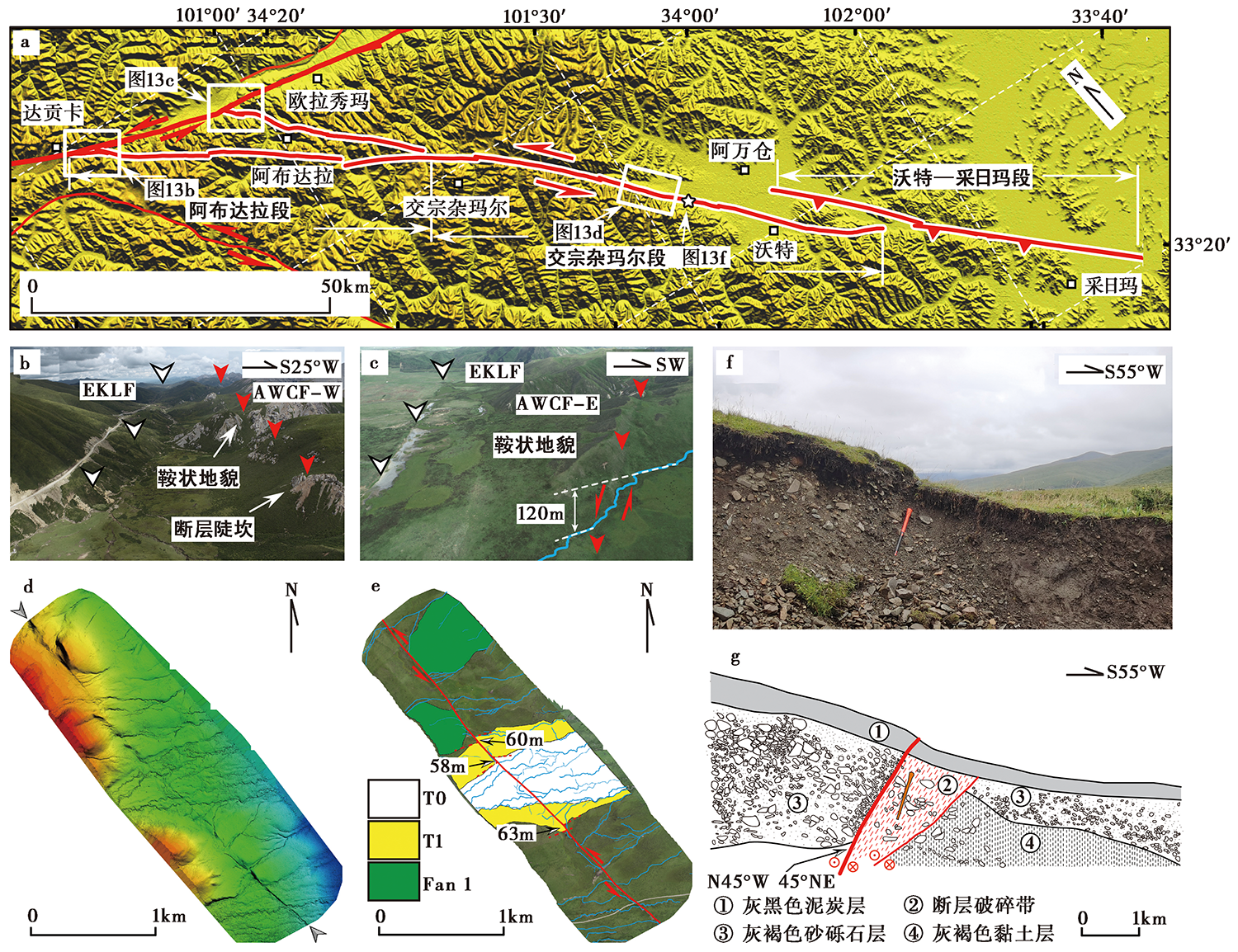
Fig. 13 Tectono-geomorphic characteristics along the Awancang Fault.

Fig. 14 Tectono-geomorphic characteristics along the Gahai Fault.
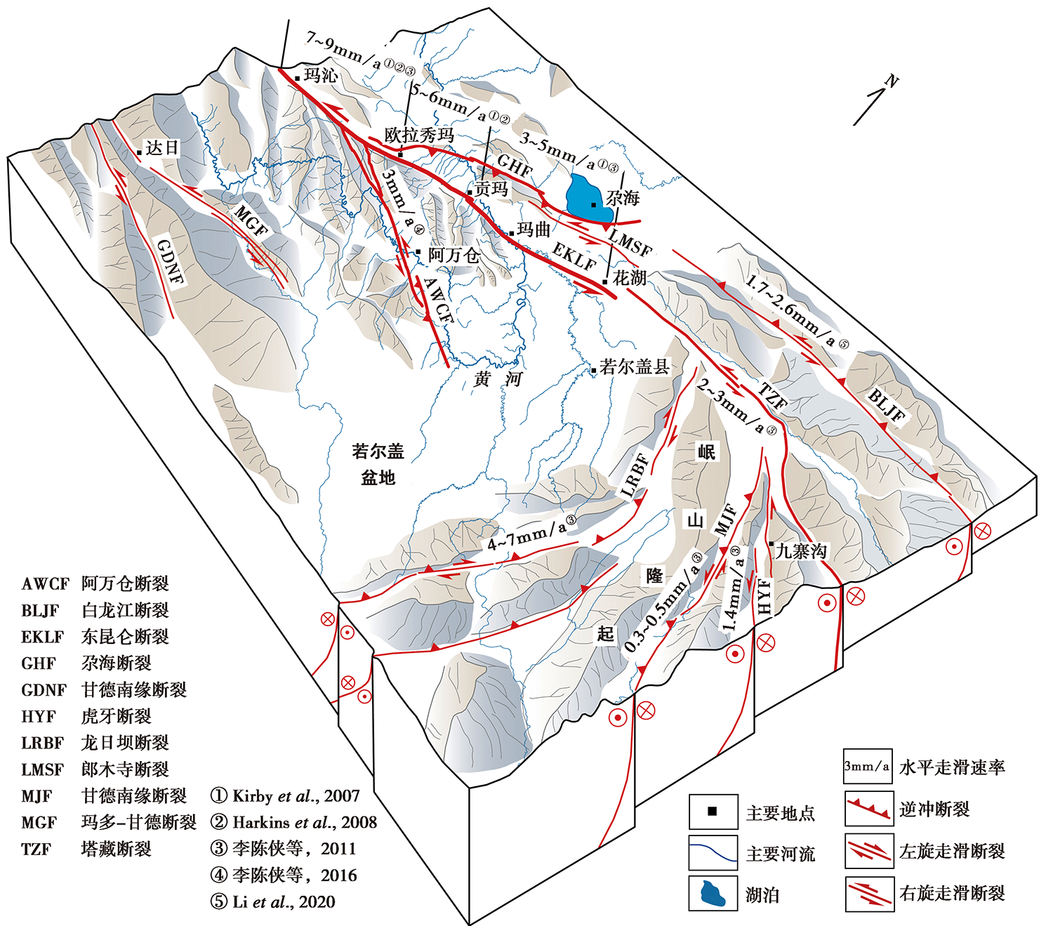
Fig. 15 Three-dimensional tectonic deformation model showing the eastward slip rate gradients along the East Kunlun fault zone.
| [1] | 常直杨. 2014. 青藏高原东缘白龙江流域地貌定量化参数体系研究[D]. 南京: 南京师范大学. |
| CHANG Zhi-yang. 2014. Research on quantitative geomorphologic indices of Bailongjiang drainage basin in the eastern Tibet Plateau based on digital elevation models[D]. Nanjing Normal University, Nanjing. (in Chinese) | |
| [2] | 邓起东. 2002. 中国活动构造研究的进展与展望[J]. 地质论评, 48(2): 169-177. |
| DENG Qi-dong. 2002. Advances and overview on researches of active tectonics in China[J]. Geological Review, 48(2): 169-177. (in Chinese) | |
| [3] | 付碧宏, 时丕龙, 贾营营. 2009. 青藏高原大型走滑断裂带晚新生代构造地貌生长及水系响应[J]. 地质科学, 44(4): 1343-1363. |
| FU Bi-hong, SHI Pi-long, JIA Ying-ying. 2009. Late Cenozoic tectono-geomorphic growth and drainage response along the large-scale strike-slip fault system, Tibetan plateau[J]. Chinese Journal of Geology, 44(4): 1343-1363. (in Chinese) | |
| [4] |
高明星, 陈桂华, 徐锡伟. 2015. 地貌参数指示的临潭-宕昌断裂带最新构造隆升差异与地震活动[J]. 地震地质, 37(3): 709-718. doi: 10.3969/j.issn.0253-4967.2015.03.004.
DOI |
| GAO Ming-xing, CHEN Gui-hua, XU Xi-wei. 2015. Geomorphic indices indicated recent differential tectonic uplift of the Lintan-Dangchang Fault and the Minxian-Zhangxian earthquake[J]. Seismology and Geology, 37(3): 709-718. (in Chinese) | |
| [5] | 高锐, 王海燕, 王成善, 等. 2011. 青藏高原东北缘岩石圈缩短变形: 深地震反射剖面再处理提供的证据[J]. 地球学报, 32(5): 513-520. |
| GAO Rui, WANG Hai-yan, WANG Cheng-shan, et al. 2011. Lithospheric deformation shortening of the northeastern Tibetan plateau: Evidence from reprocessing of deep seismic reflection data[J]. Acta Geoscientica Sinica, 32(5): 513-520. (in Chinese) | |
| [6] |
韩海辉, 高婷, 易欢, 等. 2012. 基于变点分析法提取地势起伏度: 以青藏高原为例[J]. 地理科学, 32(1): 101-104.
DOI |
|
HAN Hai-hui, GAO Ting, YI Huan, et al. 2012. Extraction of relief amplitude based on change point method: A case study on the Tibetan plateau[J]. Scientia Geographica Sinica, 32(1): 101-104. (in Chinese)
DOI |
|
| [7] | 侯冰飞. 2020. 黄河源区气候变化与径流补给的关联性分析[D]. 北京: 北京林业大学. |
| HOU Bing-fei. 2020. Analysis of inter-relationships between climate change and runoff discharge in the headwater region of Yellow River[D]. Beijing Forestry University, Beijing. (in Chinese) | |
| [8] | 李陈侠, 徐锡伟, 闻学泽, 等. 2011. 东昆仑断裂带中东部地震破裂分段性与走滑运动分解作用[J]. 中国科学(D辑), 41(9): 1295-1310. |
| LI Chen-xia, XU Xi-wei, WEN Xue-ze, et al. 2011. Rupture segmentation and slip partitioning of the mid-eastern part of the Kunlun Fault, north Tibetan plateau[J]. Science in China(Ser D), 41(9): 1295-1310. (in Chinese) | |
| [9] |
李陈侠, 徐锡伟, 闻学泽, 等. 2009. 东昆仑断裂东段玛沁-玛曲段几何结构特征[J]. 地震地质, 31(3): 441-458. doi: 10.3969/j.issn.0253-4967.2009.03.007.
DOI |
| LI Chen-xia, XU Xi-wei, WEN Xue-ze, et al. 2009. The segmental characteristics of geometrical structure of the East Kunlun active fault(Maqin-Maqu segment)[J]. Seismology and Geology, 31(3): 441-458. (in Chinese) | |
| [10] |
李陈侠, 袁道阳, 杨虎, 等. 2016. 东昆仑断裂带东段分支断裂--阿万仓断裂晚第四纪构造活动特征[J]. 地震地质, 38(1): 44-64. doi: 10.3969/j.issn.0253-4967.2016.01.004.
DOI |
| LI Chen-xia, YUAN Dao-yang, YANG Hu, et al. 2016. The tectonic activity characteristics of Awancang Fault in the late Quaternary, the sub-strand of the Eastern Kunlun Fault[J]. Seismology and Geology, 38(1): 44-64. (in Chinese) | |
| [11] | 李春峰, 贺群禄, 赵国光. 2005. 东昆仑活动断裂带东段古地震活动特征[J]. 地震学报, 25(1): 60-67. |
| LI Chun-feng, HE Qun-lu, ZHAO Guo-guang. 2005. Paleo-earthquake studies on the eastern section of the Kunlun Fault[J]. Acta Seismologica Sinica, 25(1): 60-67. (in Chinese) | |
| [12] | 刘根友. 2004. 高精度GPS定位及地壳形变分析若干问题的研究[D]. 武汉: 中国科学院测量与地球物理研究所. |
| LIU Gen-you. 2004. Some key issues relating to high precision GPS positioning and crustal deformation analysis[D]. Institute of Geodesy and Geophysics, Chinese Academy of Sciences, Wuhan. (in Chinese) | |
| [13] | 刘战庆. 2011. 东昆仑南缘布青山构造混杂岩带地质特征及区域构造研究[D]. 西安: 长安大学. |
| LIU Zhan-qing. 2011. Study on the geological characteristics and tectonic of Buqingshan melanges belt, the south margin of East Kunlun Mountains[D]. Chang'an University, Xi'an. (in Chinese) | |
| [14] | 潘家伟, 白明坤, 李超, 等. 2021. 2021年青海玛多 MS7.4 地震地表破裂带及发震构造[J]. 地质学报, 95(6): 1655-1670. |
| PAN Jia-wei, BAI Ming-kun, LI Chao, et al. 2021. Coseismic surface rupture and seismogenic structure of the 2021-05-22 Maduo(Qinghai) MS7.4 earthquake[J]. Acta Geologica Sinica, 95(6): 1655-1670. (in Chinese) | |
| [15] | 庞亚瑾, 程惠红, 张怀, 等. 2017. 巴颜喀拉块体东缘形变及九寨沟地震孕震环境数值分析[J]. 地球物理学报, 60(10): 4046-4055. |
| PANG Ya-jin, CHENG Hui-hong, ZHANG Huai, et al. 2017. Numerical modeling of crustal deformation in the eastern margin of the Bayan Har block and analysis of seismogenic environment of the 2017 Jiuzhaigou earthquake[J]. Chinese Journal of Geophysics, 60(10): 4046-4055. (in Chinese) | |
| [16] |
宋向辉, 王帅军, 潘素珍, 等. 2021. 2021年玛多 MS7.4 地震的深部构造背景[J]. 地震地质, 43(4): 757-770. doi: 10.3969/j.issn.0253-4967.2021.04.002.
DOI |
| SONG Xiang-hui, WANG Shuai-jun, PAN Su-zhen, et al. 2021. Deep seismotectonic environment of the 2021 Madoi MS7.4 earthquake[J]. Seismology and Geology, 43(4): 757-770. (in Chinese) | |
| [17] |
苏琦, 袁道阳, 谢虹. 2016a. 祁连山-河西走廊黑河流域地貌特征及其构造意义[J]. 地震地质, 38(3): 560-581. doi: 10.3969/j.issn.0253-4967.2016.03.005.
DOI |
| SU Qi, YUAN Dao-yang, XIE Hong. 2016a. Geomorphic features of the Heihe River drainage basin in western Qilianshan-Hexi Corridor and its tectonic implications[J]. Seismology and Geology, 38(3): 560-581. (in Chinese) | |
| [18] |
苏琦, 袁道阳, 谢虹, 等. 2016b. 祁连山西段疏勒河流域地貌特征及其构造意义[J]. 地震地质, 38(2): 240-258. doi: 10.3969/j.issn.0253-4967.2016.02.002.
DOI |
| SU Qi, YUAN Dao-yang, XIE Hong, et al. 2016b. Geomorphic features of the Shule River drainage basin in Qilianshan and its insight into tectonic implications[J]. Seismology and Geology, 38(2): 240-258. (in Chinese) | |
| [19] | 闻学泽. 2018. 巴颜喀拉块体东边界千年破裂历史与2008年汶川、 2013 年芦山和2017年九寨沟地震[J]. 地震学报, 40(3): 255-267. |
| WEN Xue-ze. 2018. The 2008 Wenchuan, 2013 Lushan and 2017 Jiuzhaigou earthquakes, Sichuan, in the last more than one thousand years of rupture history of the eastern margin of the Bayan Har block[J]. Acta Seismologica Sinica, 40(3): 255-267. (in Chinese) | |
| [20] | 武文娇. 2018. 山西省典型全球开放DEM数据的对比分析[D]. 太原: 太原理工大学. |
| WU Wen-jiao. 2018. Analysis and comparison of typical open global digital elevation models in Shanxi Province[D]. Taiyuan University of Technology, Taiyuan. (in Chinese) | |
| [21] | 徐晶, 邵志刚, 刘静, 等. 2017. 基于库仑应力变化分析巴颜喀拉地块东端的强震相互关系[J]. 地球物理学报, 60(10): 4056-4068. |
| XU Jing, SHAO Zhi-gang, LIU Jing, et al. 2017. Analysis of interaction between great earthquakes in the eastern Bayan Har block based on changes of Coulomb stress[J]. Chinese Journal of Geophysics, 60(10): 4056-4068. (in Chinese) | |
| [22] |
徐伟, 刘志成, 袁兆德, 等. 2017. 华山山前河流地貌参数及其构造意义[J]. 地震地质, 39(6): 1316-1335. doi: 10.3969/j.issn.0253-4967.2017.06.015.
DOI |
| XU Wei, LIU Zhi-cheng, YUAN Zhao-de, et al. 2017. River geomorphic parameters of the Huashan piedmont and their tectonic implications[J]. Seismology and Geology, 39(6): 1316-1335. (in Chinese) | |
| [23] | 詹艳, 梁明剑, 孙翔宇, 等. 2021. 2021年5月22日青海玛多 MS7.4 地震深部环境及发震构造模式[J]. 地球物理学报, 64(7): 2231-2251. |
| ZHAN Yan, LIANG Ming-jian, SUN Xiang-yu, et al. 2021. Deep structure and seismogenic pattern of the 2021.5.22 Madoi(Qinghai) MS7.4 earthquake[J]. Chinese Journal of Geophysics, 64(7): 2231-2251. (in Chinese) | |
| [24] | 张国民, 田勤俭, 王辉. 2003. 可可西里-东昆仑活动构造带强震活动研究[J]. 地学前缘, 10(1): 39-46. |
| ZHANG Guo-min, TIAN Qin-jian, WANG Hui. 2003. Strong earthquake activities in Kekexili-East Kunlun Mountains active fault zone, Northwest China[J]. Earth Science Frontiers, 10(1): 39-46. (in Chinese) | |
| [25] | 张会平, 刘少峰, 孙亚平, 等. 2006. 基于SRTM-DEM区域地形起伏的获取及应用[J]. 国土资源遥感, (1): 31-35. |
| ZHANG Hui-ping, LIU Shao-feng, SUN Ya-ping, et al. 2006. The acquisition of local topographic relief and its application: An SRTM-DEM analysis[J]. Remote Sensing for Land & Resources, (1): 31-35. (in Chinese) | |
| [26] | 张岳桥, 马寅生, 杨农, 等. 2005. 西秦岭地区东昆仑-秦岭断裂系晚新生代左旋走滑历史及其向东扩展[J]. 地球学报, 25(1): 1-8. |
| ZHANG Yue-qiao, MA Yin-sheng, YANG Nong, et al. 2005. Late Cenozoic left-slip faulting process of the East Kunlun-Qinling fault system in West Qinling region and its eastward propagation[J]. Acta Geoscientica Sinica, 25(1): 1-8. (in Chinese) | |
| [27] | 赵国华, 李勇, 颜照坤, 等. 2014. 龙门山中段山前河流Hack剖面和面积-高程积分的构造地貌研究[J]. 第四纪研究, 34(2): 302-310. |
| ZHAO Guo-hua, LI Yong, YAN Zhao-kun, et al. 2014. Tectonic geomorphology analysis of piedmont rivers of the middle Longmenshan Basin on Hack profile and hypsometric integral[J]. Quaternary Sciences, 34(2): 302-310. (in Chinese) | |
| [28] | 赵洪壮, 李有利, 杨景春, 等. 2010. 面积高度积分的面积依赖与空间分布特征[J]. 地理研究, 29(2): 271-282. |
|
ZHAO Hong-zhuang, LI You-li, YANG Jing-chun, et al. 2010. Influence of area and space dependence for hypsometric integral and its geological implications[J]. Geographical Research, 29(2): 271-282. (in Chinese)
DOI |
|
| [29] |
周朝, 何宏林, 魏占玉, 等. 2020. 地貌参数方法在小尺度地貌研究中的应用: 以北天山独山子背斜为例[J]. 地震地质, 42(6): 1492-1508. doi: 10.3969/j.issn.0253-4967.2020.06.014.
DOI |
| ZHOU Chao, HE Hong-lin, WEI Zhan-yu, et al. 2020. The application of geomorphic indexes in small-scale geomorphology: A case study in Dushanzi anticline in the northern Chinese Tian Shan Foreland[J]. Seismology and Geology, 42(6): 1492-1508. (in Chinese) | |
| [30] |
Alipoor R, Poorkermani M, Zare M, et al. 2011. Active tectonic assessment around Rudbar Lorestan dam site, High Zagros Belt(SW of Iran)[J]. Geomorphology, 128(1-2): 1-14.
DOI URL |
| [31] |
Brookfield M E. 1998. The evolution of the great river systems of southern Asia during the Cenozoic India-Asia collision: Rivers draining southwards[J]. Geomorphology, 22(3): 285-312.
DOI URL |
| [32] |
Chen Y C, Sung Q, Cheng K Y. 2003. Along-strike variations of morphotectonic features in the western foothills of Taiwan: Tectonic implications based on stream-gradient and hypsometric analysis[J]. Geomorphology, 56(1-2): 109-137.
DOI URL |
| [33] | Du J X, Fu B H, Guo Q, et al. 2019. Segmentation and termination of the surface rupture zone produced by the 1932 MS7.6 Changma earthquake: New insights into the slip partitioning of the eastern Altyn Tagh fault system[J]. The Geological Society of America, 12(1): 19-39. |
| [34] |
Font M, Amorese D, Lagarde J L. 2010. DEM and GIS analysis of the stream gradient index to evaluate effects of tectonics: The Normandy intraplate area(NW France)[J]. Geomorphology, 119(3): 172-180.
DOI URL |
| [35] |
Fu B H, Awata Y. 2007. Displacement and timing of left-lateral faulting in the Kunlun fault zone, northern Tibet, inferred from geologic and geomorphic features[J]. Journal of Asian Earth Sciences, 29(2-3): 253-265.
DOI URL |
| [36] |
Fu B H, Walker R, Sandiford M. 2011. The 2008 Wenchuan earthquake and active tectonics of Asia[J]. Journal of Asian Earth Sciences, 40(4): 797-804.
DOI URL |
| [37] |
Gao M X, Zeilinger G, Xu X W, et al. 2013. DEM and GIS analysis of geomorphic indices for evaluating recent uplift of the northeastern margin of the Tibetan plateau, China[J]. Geomorphology, 190: 61-72.
DOI URL |
| [38] | Hack J T. 1973. Stream-profile analysis and stream-gradient index[J]. Journal of Research of the US Geological Survey, 1(4): 421-429. |
| [39] |
Hamdouni R E, Irigaray C, Fernández T, et al. 2008. Assessment of relative active tectonics, southwest border of the Sierra Nevada(southern Spain)[J]. Geomorphology, 96(1-2): 150-173.
DOI URL |
| [40] | Harkins N, Kirby N. 2008. Fluvial terrace riser degradation and determination of slip rates on strike-slip faults: An example from the Kunlun Fault, China[J]. Geophysical Research Letters, 35(5): 1-6. |
| [41] |
Hurtrez J E, Sol C, Lucazeau F. 1999. Effect of drainage area on hypsometry from an analysis of small-scale drainage basins in the Siwalik Hills(Central Nepal)[J]. Earth Surface Processes and Landforms, 24(9): 799-808.
DOI URL |
| [42] | Kirby E, Harkins N. 2013. Distributed deformation around the eastern tip of the Kunlun Fault[J]. International Journal of Earth Sciences(Geologische Rundschau), 102(7): 1759-1772. |
| [43] | Kirby E, Harkins N, Wang E, et al. 2007. Slip rate gradients along the eastern Kunlun Fault[J]. Tectonics, 26(2): 1-16. |
| [44] | Li H L, Zhang Y, Dong S, et al. 2020. Neotectonics of the Bailongjiang and Hanan faults: New insights in the late Cenozic deformation along the eastern margin of the Tibetan Plateau[J]. CSA Bulletin, 132(9-10): 1845-1862. |
| [45] |
Obaid A K, Allen M B. 2019. Landscape expressions of tectonics in the Zagros fold-and-thrust belt[J]. Tectonophysics, 766(B2): 20-30.
DOI URL |
| [46] |
Pérez-Peña J V, Azañón J M, Azor A. 2009a. CalHypso: An ArcGIS extension to calculate hypsometric curves and their statistical moments. Applications to drainage basin analysis in SE Spain[J]. Computers and Geosciences, 35(6): 1214-1223.
DOI URL |
| [47] |
Pérez-Peña J V, Azañón J M, Azor A, et al. 2009b. Spatial analysis of stream power using GIS: SLK anomaly maps[J]. Earth Surface Processes and Landforms, 34(1): 16-25.
DOI URL |
| [48] |
Pike R J, Wilson S E. 1971. Elevation-relief ratio, hypsometric integral, and geomorphic area-altitude analysis[J]. Geological Society of America Bulletin, 82(4): 1079-1084.
DOI URL |
| [49] |
Resor P G, Cooke M L, Marshall S T, et al. 2018. Influence of fault geometry on the spatial distribution of long-term slip with implications for determining representative fault-slip rates[J]. Bulletin of the Seismological Society of America, 108(4): 1837-1852.
DOI URL |
| [50] |
Sarp G, Toprak V, Duzgun S. 2012. Activity level of tectonic basins, western section of the North Anatolian fault zone, Turkey[J]. International Geology Review, 55(3): 350-366.
DOI URL |
| [51] |
Seeber L, Gornitz V. 1983. River profiles along the Himalayan Arc as indicators of active tectonics[J]. Tectonophysics, 92(4): 335-367.
DOI URL |
| [52] |
Strahler A N. 1952. Hypsometric(area-altitude)analysis of erosional topography[J]. Geological Society of America Bulletin, 63(11): 1117-1142.
DOI URL |
| [53] |
Sun X Y, Zhan Y, Zhao L Q, et al. 2019. Electrical structure of the Kunlun-Qinling fault system, northeastern Tibetan plateau, inferred from 3-D inversion of magnetotelluric data[J]. Journal of Asian Earth Sciences, 181(3): 103910.
DOI URL |
| [54] |
van der Woerd J, Tapponnier P, Ryerson F J, et al. 2002. Uniform postglacial slip-rate along the central 600km of the Kunlun Fault(Tibet), from 26Al, 10Be, and 14C dating of riser offsets, and climatic origin of the regional morphology[J]. Geophysical Journal International, 148(3): 356-388.
DOI URL |
| [55] |
Whipple K X, Meade B J. 2006. Orogen response to changes in climatic and tectonic forcing[J]. Earth and Planetary Science Letters, 243(1-2): 218-228.
DOI URL |
| [56] |
Whipple K X, Tucker G E. 1999. Dynamics of the stream-power river incision model: Implications for height limits of mountain ranges, landscape response timescales, and research needs[J]. Journal of Geophysical Research, 104(B8): 17661-17674.
DOI URL |
| [57] |
Yin A, Rumelhart P E, Butler R, et al. 2002. Tectonic history of the Altyn Tagh fault system in northern Tibet inferred from Cenozoic sedimentation[J]. Geological Society of America Bulletin, 114(10): 1257-1295.
DOI URL |
| [58] | Zechar J D, Frankel K L. 2009. Incorporating and reporting uncertainties in fault slip rates[J]. Journal of Geophysical Research: Solid Earth, 114(B12): 1-9. |
| [59] |
Zhu L, Ji L, Jiang F Y. 2020. Variations in locking along the East Kunlun Fault, Tibetan plateau, China, using GPS and leveling data[J]. Pure and Applied Geophysics, 177(10): 1-15.
DOI URL |
| [60] |
Zhu L, Ji L, Liu C. 2021. Interseismic slip rate and locking along the Maqin-Maqu segment of the East Kunlun Fault, northern Tibetan plateau, based on Sentinel-1 images[J]. Journal of Asian Earth Sciences, 211(121): 104703.
DOI URL |
| [1] | ZHOU Chao, HE Hong-lin, WEI Zhan-yu, SU Peng, REN Guang-xue. THE APPLICATION OF GEOMORPHIC INDEXES IN SMALL-SCALE GEOMORPHOLOGY:A CASE STUDY IN DUSHANZI ANTICLINE IN THE NORTHERN CHINESE TIAN SHAN FORELAND [J]. SEISMOLOGY AND GEOLOGY, 2020, 42(6): 1492-1508. |
| [2] | GAO Ze-min, LIU Xing-wang, SHAO Yan-xiu, XIE Hong. GEOMORPHOLOGICAL CHARACTERISTICS OF DAQINGSHAN DRAINAGE AREA IN THE NORTHERN MARGIN OF HETAO BASIN [J]. SEISMOLOGY AND GEOLOGY, 2019, 41(6): 1317-1332. |
| [3] |
SU Qi, YUAN Dao-yang, XIE Hong, SHAO Yan-xiu, LIANG Ming-jian1. Lanzhou Institute of Seismology, China Earthquake Administration, Lanzhou 730000, China; 2. Lanzhou National Observatory of Geophysic. GEOMORPHIC FEATURES OF THE SHULE RIVER DRAINAGE BASIN IN QILIANSHAN AND ITS INSIGHT INTO TECTONIC IMPLICATIONS [J]. SEISMOLOGY AND GEOLOGY, 2016, 38(2): 240-258. |
| Viewed | ||||||
|
Full text |
|
|||||
|
Abstract |
|
|||||
