SEISMOLOGY AND GEOLOGY ›› 2022, Vol. 44 ›› Issue (6): 1615-1633.DOI: 10.3969/j.issn.0253-4967.2022.06.015
• Research paper • Previous Articles Next Articles
ZHANG Su-xiang1)( ), SHENG Shu-zhong1),*(), XI Biao2), FANG Li-hua3), LÜ Jian4), WANG Gan-jiao4), ZHANG Xiao1)
Received:2022-02-28
Revised:2022-05-09
Online:2022-12-20
Published:2023-01-21
Contact:
SHENG Shu-zhong
张苏祥1)(), 盛书中1),*(), 席彪2), 房立华3), 吕坚4), 王甘娇4), 张潇1)
通讯作者:
盛书中
作者简介:张苏祥, 男, 1997年生, 2020年于防灾科技学院获地球物理学专业学士学位, 现为东华理工大学地球物理学专业在读硕士研究生, 主要从事发震构造和构造应力场等方面研究, E-mail: zhangsuxiang@ecut.edu.cn。
基金资助:CLC Number:
ZHANG Su-xiang, SHENG Shu-zhong, XI Biao, FANG Li-hua, LÜ Jian, WANG Gan-jiao, ZHANG Xiao. AUTOMATIC FAULT IDENTIFICATION METHOD BASED ON IMPROVED DBSCAN ALGORITHM AND ITS APPLICATION TO TANGSHAN AREA[J]. SEISMOLOGY AND GEOLOGY, 2022, 44(6): 1615-1633.
张苏祥, 盛书中, 席彪, 房立华, 吕坚, 王甘娇, 张潇. 基于改进的DBSCAN算法自动识别断层方法研究及其在唐山地区的应用[J]. 地震地质, 2022, 44(6): 1615-1633.
Add to citation manager EndNote|Ris|BibTeX
URL: https://www.dzdz.ac.cn/EN/10.3969/j.issn.0253-4967.2022.06.015
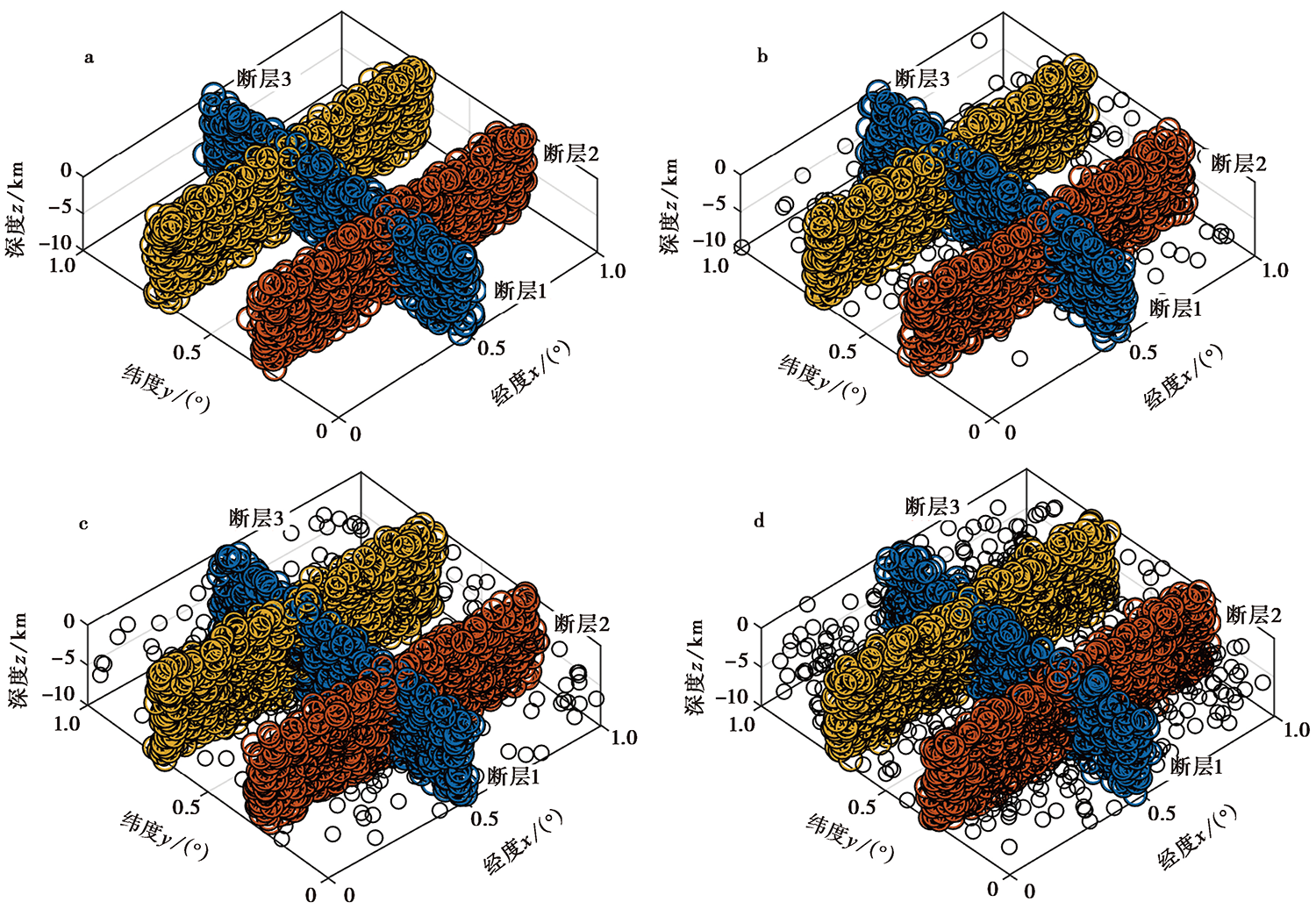
Fig. 1 The spatial distribution of synthetic seismic data(a) and adding random earthquakes which account for 5%, 10% and 20% of total seismic events(b-d), respectively.
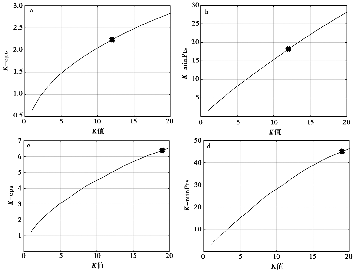
Fig. 2 K-eps, K-minPts diagrams of first clustering(a, b) and second clustering(c, d) for synthetic data with 5% noise.
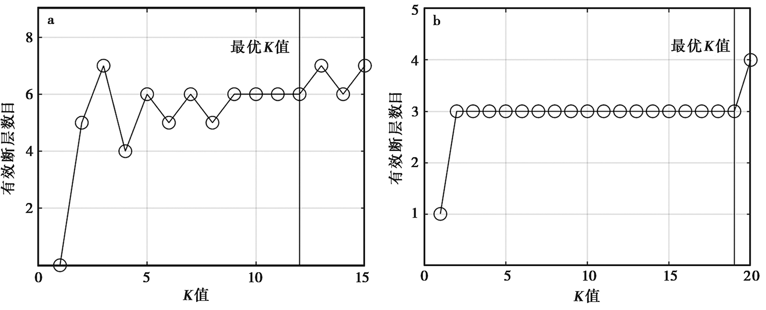
Fig. 3 K-number of effective faults diagram of first clustering(a) and second clustering(b) for synthetic data with 5% noise.
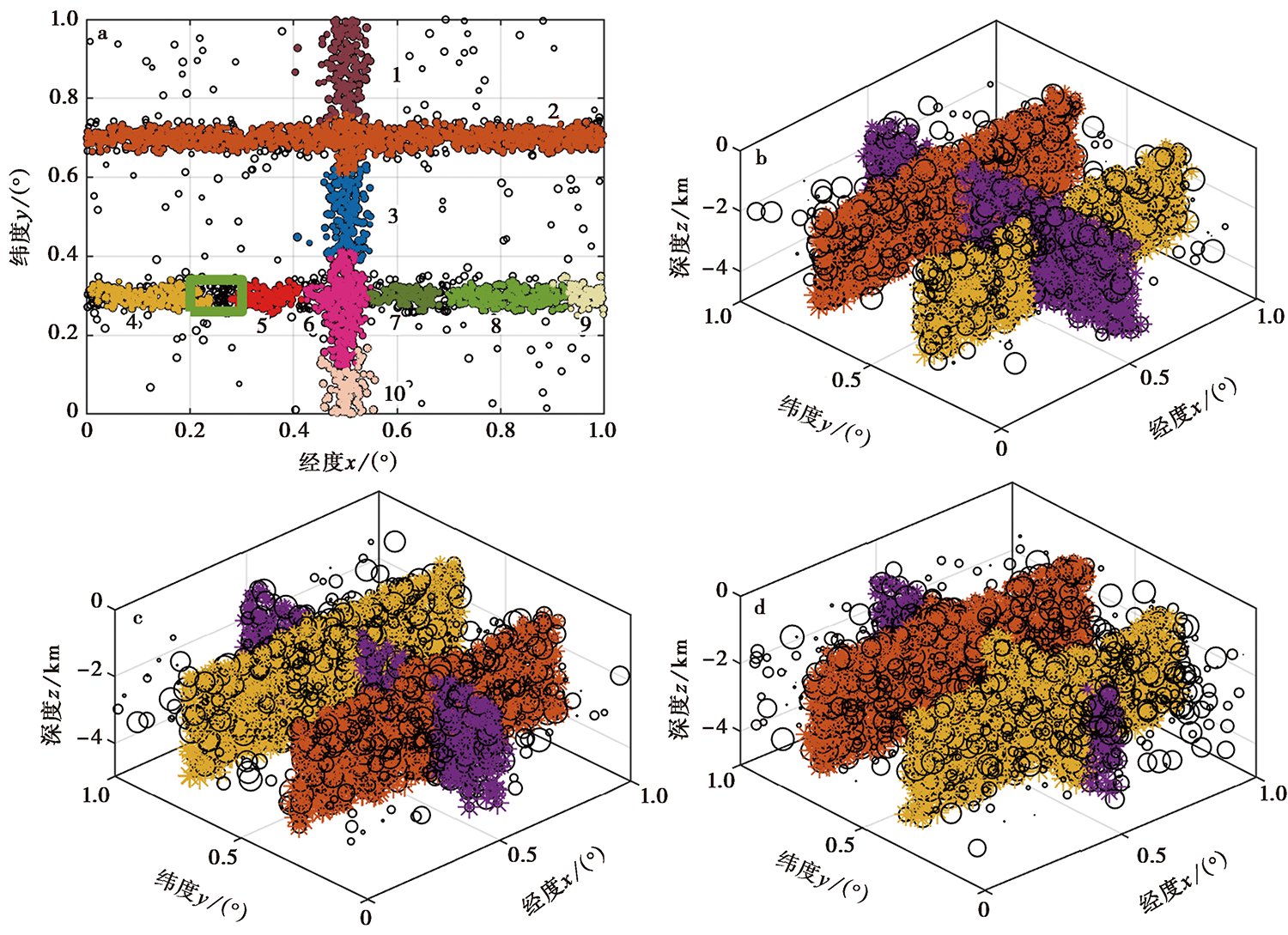
Fig. 4 Automatic fault plane recognition results for synthetic data.
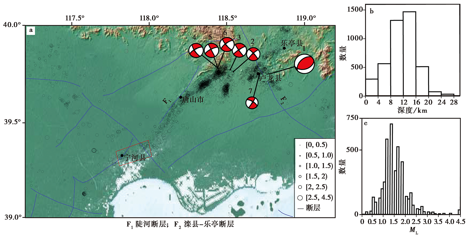
Fig. 5 Distribution of epicenter(a), depth(b)and magnitude(c) of the Tangshan earthquake sequence, China.
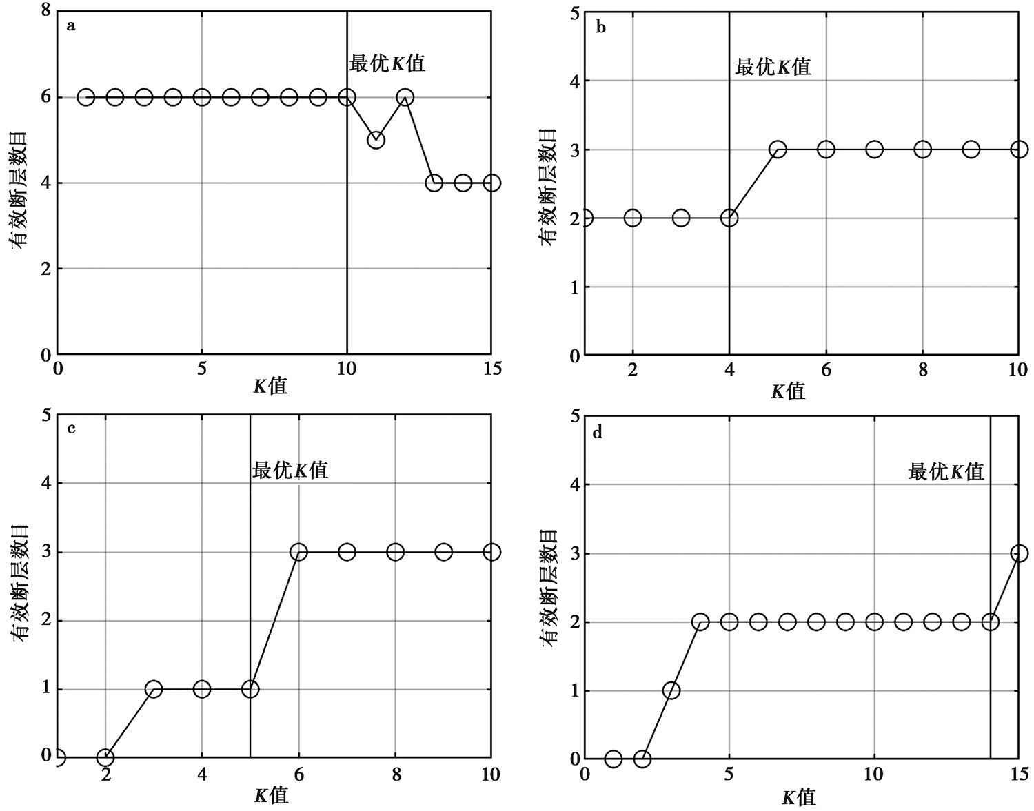
Fig. 6 Relationship between K value of four-level density clustering and the number of effective faults in Tangshan area(a-d).
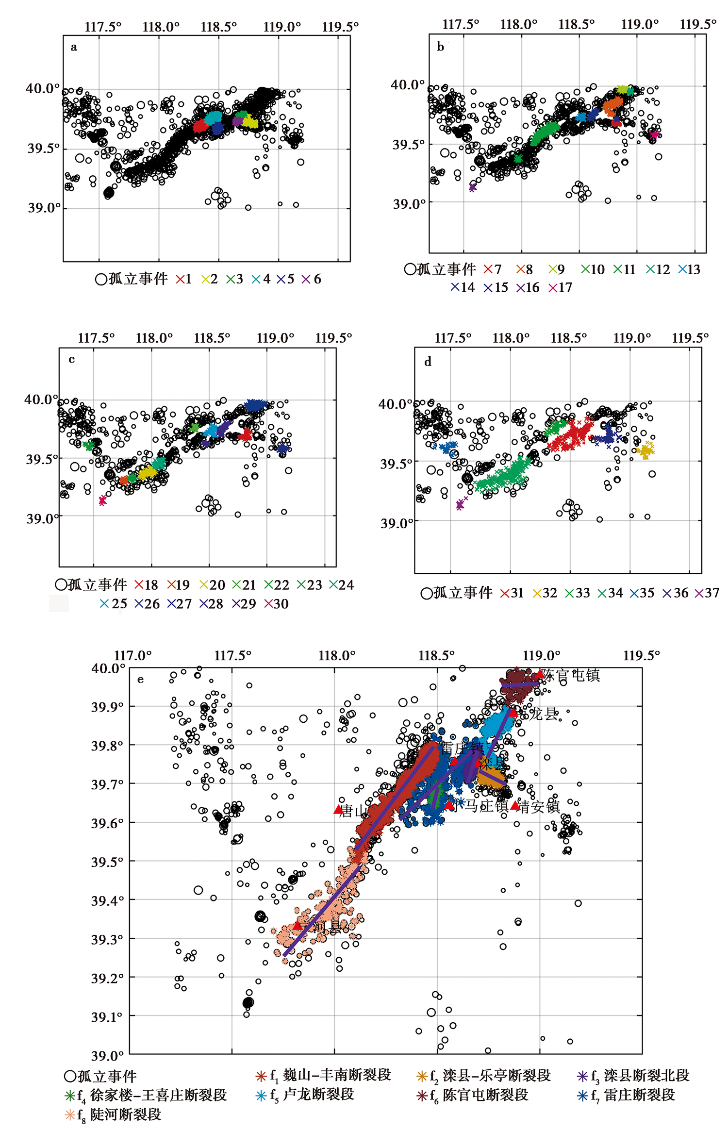
Fig. 7 Graph of the first, second, third and fourth clustering results(a-d) and final fault identification results(e)in Tangshan area.
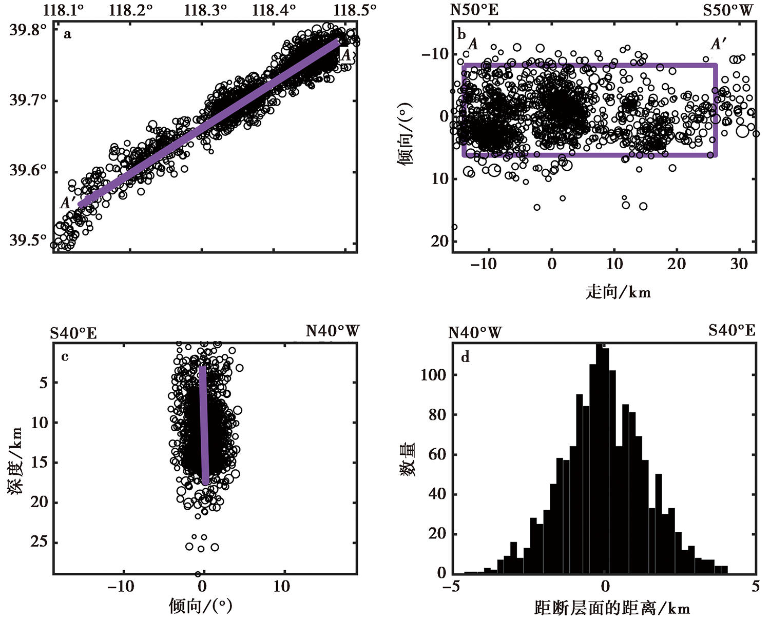
Fig. 8 The fitting result by using small earthquakes of Weishan-Fengnan Fault(f1).
| 断层符号 | 断层名 | 小地震 个数 | 走向/(°) | 倾角/(°) | 数据来源 | ||
|---|---|---|---|---|---|---|---|
| 值 | 标准差 | 值 | 标准差 | ||||
| f1 | 巍山-丰南断裂段 | 1559 | 230.4 | 0.003 | 88.4 | 0.01 | 本文结果 |
| f2 | 滦县-乐亭断裂段 | 506 | 132.2 | 0.03 | 89.3 | 0.02 | 本文结果 |
| 160 | 118.4 | 1.9 | 76.9 | 2.0 | 万永革等, | ||
| 404 | 125.1 | 1.6 | 76.2 | 1.8 | 胡晓辉等, | ||
| f3 | 滦县断裂北段 | 336 | 31.0 | 0.02 | 88.2 | 0.01 | 本文结果 |
| f4 | 徐家楼-王喜庄断裂段 | 351 | 191.3 | 0.03 | 88.4 | 0.01 | 本文结果 |
| f5 | 卢龙断裂段 | 243 | 31.7 | 0.04 | 88.6 | 0.03 | 本文结果 |
| 176 | 39.0 | 0.9 | 86.7 | 1.3 | 万永革等, | ||
| 694 | 46.1 | 0.6 | 89.3 | 1.5 | 胡晓辉等, | ||
| f6 | 陈官屯断裂段 | 144 | 84.9 | 0.06 | 85.4 | 0.04 | 本文结果 |
| f7 | 雷庄断裂段 | 244 | 229.5 | 0.03 | 73.8 | 0.04 | 本文结果 |
| f8 | 陡河断裂段 | 225 | 229.1 | 0.03 | 51.6 | 0.06 | 本文结果 |
| 61 | 253.3 | 3.9 | 66.0 | 5.0 | 万永革等, | ||
| 33 | 246.6 | 4.0 | 81.8 | 4.2 | 胡晓辉等, |
Table1 Fault plane parameters of Tangshan region obtained by using the automatic fault identification method
| 断层符号 | 断层名 | 小地震 个数 | 走向/(°) | 倾角/(°) | 数据来源 | ||
|---|---|---|---|---|---|---|---|
| 值 | 标准差 | 值 | 标准差 | ||||
| f1 | 巍山-丰南断裂段 | 1559 | 230.4 | 0.003 | 88.4 | 0.01 | 本文结果 |
| f2 | 滦县-乐亭断裂段 | 506 | 132.2 | 0.03 | 89.3 | 0.02 | 本文结果 |
| 160 | 118.4 | 1.9 | 76.9 | 2.0 | 万永革等, | ||
| 404 | 125.1 | 1.6 | 76.2 | 1.8 | 胡晓辉等, | ||
| f3 | 滦县断裂北段 | 336 | 31.0 | 0.02 | 88.2 | 0.01 | 本文结果 |
| f4 | 徐家楼-王喜庄断裂段 | 351 | 191.3 | 0.03 | 88.4 | 0.01 | 本文结果 |
| f5 | 卢龙断裂段 | 243 | 31.7 | 0.04 | 88.6 | 0.03 | 本文结果 |
| 176 | 39.0 | 0.9 | 86.7 | 1.3 | 万永革等, | ||
| 694 | 46.1 | 0.6 | 89.3 | 1.5 | 胡晓辉等, | ||
| f6 | 陈官屯断裂段 | 144 | 84.9 | 0.06 | 85.4 | 0.04 | 本文结果 |
| f7 | 雷庄断裂段 | 244 | 229.5 | 0.03 | 73.8 | 0.04 | 本文结果 |
| f8 | 陡河断裂段 | 225 | 229.1 | 0.03 | 51.6 | 0.06 | 本文结果 |
| 61 | 253.3 | 3.9 | 66.0 | 5.0 | 万永革等, | ||
| 33 | 246.6 | 4.0 | 81.8 | 4.2 | 胡晓辉等, |
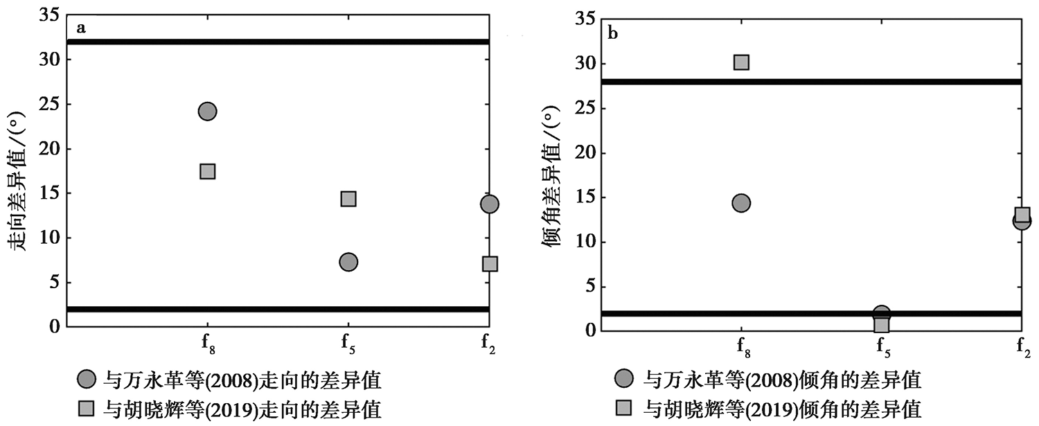
Fig. 9 Difference of fault strike(a)and dip(b)between the results of this paper and those of previous studies.
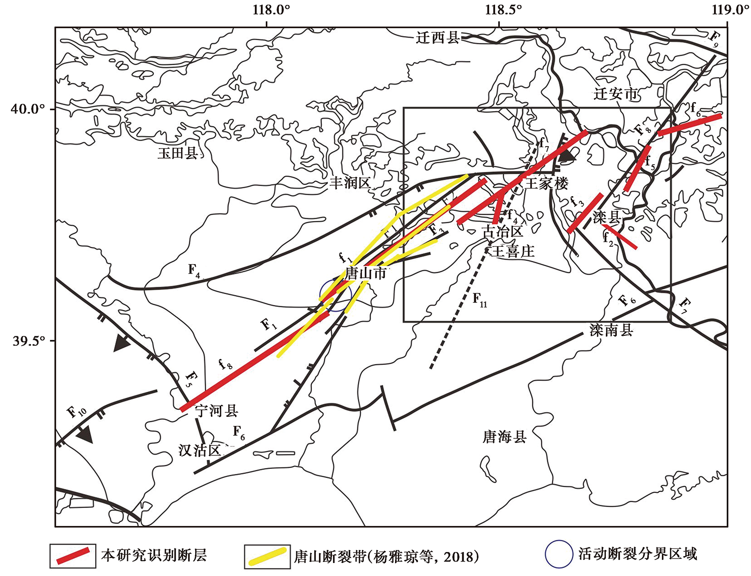
Fig. 10 Distribution of major faults in Tangshan area(after LIU Kang et al., 2015).
| 序号 | 日期 | 东经 /(°) | 北纬 /(°) | 震级 /MW | 震源 深度 /km | 走向 /(°) | 倾角 /(°) | 滑动角 /(°) | 所属断层 | 数据来源 |
|---|---|---|---|---|---|---|---|---|---|---|
| 1 | 1976-07-28 | 118.78 | 39.75 | 7.0 | 15.0 | 72 | 44 | -110 | 卢龙断裂段 | GCMT |
| 2 | 2012-05-28 | 118.54 | 39.76 | 4.7 | 23.5 | 227 | 80 | 172 | 雷庄断裂段 | GCMT |
| 3 | 2020-07-11 | 118.52 | 39.77 | 5.0 | 23.0 | 236 | 81 | -175 | 雷庄断裂段 | GCMT |
| 4 | 2020-07-12 | 118.44 | 39.78 | 5.1 | 10.0 | 241 | 73 | -164 | 巍山-丰南断裂段 | 中国地震局地球物理研究所* |
| 5 | 2020-07-12 | 118.44 | 39.78 | 5.1 | 10.0 | 243 | 75 | -180 | 巍山-丰南断裂段 | 郭祥云等* |
| 6 | 2020-07-12 | 118.44 | 39.78 | 5.1 | 10.0 | 234 | 73 | -168 | 巍山-丰南断裂段 | 梁珊珊等* |
| 7 | 2021-04-16 | 118.71 | 39.75 | 4.3 | 9.0 | 302 | 70 | -3 | 滦县-乐亭断裂段 | 河北省地震局* |
Table2 Catalog of focal mechanism
| 序号 | 日期 | 东经 /(°) | 北纬 /(°) | 震级 /MW | 震源 深度 /km | 走向 /(°) | 倾角 /(°) | 滑动角 /(°) | 所属断层 | 数据来源 |
|---|---|---|---|---|---|---|---|---|---|---|
| 1 | 1976-07-28 | 118.78 | 39.75 | 7.0 | 15.0 | 72 | 44 | -110 | 卢龙断裂段 | GCMT |
| 2 | 2012-05-28 | 118.54 | 39.76 | 4.7 | 23.5 | 227 | 80 | 172 | 雷庄断裂段 | GCMT |
| 3 | 2020-07-11 | 118.52 | 39.77 | 5.0 | 23.0 | 236 | 81 | -175 | 雷庄断裂段 | GCMT |
| 4 | 2020-07-12 | 118.44 | 39.78 | 5.1 | 10.0 | 241 | 73 | -164 | 巍山-丰南断裂段 | 中国地震局地球物理研究所* |
| 5 | 2020-07-12 | 118.44 | 39.78 | 5.1 | 10.0 | 243 | 75 | -180 | 巍山-丰南断裂段 | 郭祥云等* |
| 6 | 2020-07-12 | 118.44 | 39.78 | 5.1 | 10.0 | 234 | 73 | -168 | 巍山-丰南断裂段 | 梁珊珊等* |
| 7 | 2021-04-16 | 118.71 | 39.75 | 4.3 | 9.0 | 302 | 70 | -3 | 滦县-乐亭断裂段 | 河北省地震局* |
| [1] | 杜晨晓, 谢富仁, 张扬, 等. 2010. 1976年 MS7.8 唐山地震断层动态破裂及近断层强地面运动特征[J]. 地球物理学报, 53(2): 290-304. |
| DU Chen-xiao, XIE Fu-ren, ZHANG Yang, et al. 2010. 3D modeling of dynamic fault rupture and strong ground motion of the 1976 MS7.8 Tangshan earthquake[J]. Chinese Journal of Geophysics, 53(2): 290-304. (in Chinese) | |
| [2] | 付泽强, 王晓锋. 2018. 基于变参数的DBSCAN算法[J]. 网络安全技术与应用, 212(8): 37-39. |
| FU Ze-qiang, WANG Xiao-feng. 2018. DBSCAN algorithm based on variable parameters[J]. Network Security Technology and Application, 212(8): 37-39. (in Chinese) | |
| [3] | 高彬, 周仕勇, 蒋长胜. 2016. 基于地震活动性资料估计鄂尔多斯块体周缘构造断层面倾角[J]. 地球物理学报, 59(7): 2444-2452. |
| GAO Bin, ZHOU Shi-yong, JIANG Chang-sheng. 2016. Estimate of dip angles of faults around Ordos Block based on earthquakes[J]. Chinese Journal of Geophysics, 59(7): 2444-2452. (in Chinese) | |
| [4] | 侯雄文. 2017a. 浅析DBSCAN算法中参数设置问题的研究[J]. 科教导刊(电子版), (30): 266-267. |
| HOU Xiong-wen. 2017a. Study on parameters setting in DBSCAN algorithm[J]. The Guide of Science & Education(Electronic Edition), (30): 266-267. (in Chinese) | |
| [5] | 侯雄文. 2017b. 浅析DBSCAN算法中参数设置问题的研究[EB/OL].(2017-10-30)[2021-9-10]. http://www.cqvip.com/main/viewer.aspx?id=673919599&type=5&sign=34410979c32d75c45fee9e654591182f&view=1. |
| HOU Xiong-wen. 2017b. Study on parameters setting in DBSCAN algorithm[EB/OL].(2017-10-30)[2021-9-10]. http://www.cqvip.com/main/viewer.aspx?id=673919599&type=5&sign=34410979c32d75c45fee9e654591 182f&view=1. | |
| [6] | 胡晓辉, 盛书中, 万永革, 等. 2019. 基于国家地震科学数据开展断层面参数研究的初探: 以唐山地震为例[J]. 震灾防御技术, 14(2): 341-351. |
| HU Xiao-hui, SHENG Shu-zhong, WAN Yong-ge, et al. 2019. Preliminary study on fault parameters based on national seismic data: An example of Tangshan earthquake[J]. Earthquake Disaster Prevention Technology, 14(2): 341-351. (in Chinese) | |
| [7] | 黄文辉, 康英, 苏柱金, 等. 2016. 全国统一编目系统设计与实现[J]. 地震地磁观测与研究, 37(4): 170-175. |
| HUANG Wen-hui, KANG Ying, SU Zhu-jin, et al. 2016. The design and implementation of unified national cataloging system[J]. Seismological and Geomagnetic Observation and Research, 37(4): 170-175. (in Chinese) | |
| [8] | 李钦祖, 张之立, 靳雅敏, 等. 1980. 唐山地震的震源机制[J]. 地震地质, 2(4): 59-67. |
| LI Qin-zu, ZHANG Zhi-li, JIN Ya-min, et al. 1980. Focal mechanism of the Tangshan earthquake[J]. Seismology and Geology, 2(4): 59-67. (in Chinese) | |
| [9] |
李文杰, 闫世强, 蒋莹, 等. 2019. 自适应确定DBSCAN算法参数的算法研究[J]. 计算机工程与应用, 55(5): 1-7.
DOI |
|
LI Wen-jie, YAN Shi-qiang, JIANG Ying, et al. 2019. Research on method of self-adaptive determination of DBSCAN algorithm parameters[J]. Computer Engineering and Applications, 55(5): 1-7. (in Chinese)
DOI |
|
| [10] | 刘亢, 曲国胜, 房立华, 等. 2015. 唐山古冶、 滦县地区中小地震活动与构造关系研究[J]. 地震, 35(2): 111-120. |
| LIU Kang, QU Guo-sheng, FANG Li-hua, et al. 2015. Relationship between tectonics and small to moderate earthquakes in Guye and Luanxian area, Hebei Province[J]. Earthquake, 35(2): 111-120. (in Chinese) | |
| [11] | 盛书中. 2015. 鄂尔多斯块体周缘地壳应力场与断层面参数的研究[D]. 北京: 中国地震局地球物理研究所:67-69. |
| SHENG Shu-zhong. 2015. Study on the crustal stress field and the fault plane parameter of circum-Ordos block region[D]. Institute of Geophysics, China Earthquake Administration, Beijing: 67-69. (in Chinese) | |
| [12] | 盛书中, 万永革, 蒋长胜, 等. 2015. 2015年尼泊尔 MS8.1 强震对中国大陆静态应力触发影响的初探[J]. 地球物理学报, 58(5): 1834-1842. |
| SHENG Shu-zhong, WAN Yong-ge, JIANG Chang-sheng, et al. 2015. Preliminary study on the static stress triggering effects on China mainland with the 2015 Nepal MS8.1 earthquake[J]. China Journal of Geophysics, 58(5): 1834-1842. (in Chinese) | |
| [13] | 盛书中, 万永革, 王未来, 等. 2014. 2010年玉树 MS7.1 地震发震断层面参数的确定[J]. 地球物理学进展, 29(4): 1555-1562. |
| SHENG Shu-zhong, WAN Yong-ge, WANG Wei-lai, et al. 2014. The determination of seismogenic fault plane parameters of Yushu MS7.1 earthquake in 2010[J]. Progress in Geophysics, 29(4): 1555-1562. (in Chinese) | |
| [14] | 万永革, 沈正康, 刁桂苓, 等. 2008. 利用小震分布和区域应力场确定大震断层面参数方法及其在唐山地震序列中的应用[J]. 地球物理学报, 51(3): 793-804. |
| WAN Yong-ge, SHEN Zheng-kang, DIAO Gui-ling, et al. 2008. An algorithm of fault parameter determination using distribution of small earthquakes and parameters of regional stress field and its application to Tangshan earthquake sequence[J]. China Journal of Geophysics, 51(3): 793-804. (in Chinese) | |
| [15] | 杨雅琼, 冯向东, 刁桂苓, 等. 2018. 震源断层方法在活断层探测中的应用[J]. 灾害学, 33(2): 70-75. |
| YANG Ya-qiong, FENG Xiang-dong, DIAO Gui-ling, et al. 2018. The application of seismogenic fault method in active fault detection[J]. Journal of Catastrophology, 33(2): 70-75. (in Chinese) | |
| [16] | 杨雅琼, 王晓山, 万永革, 等. 2016. 由震源机制解推断唐山地震序列发震断层的分段特征[J]. 地震学报, 38(4): 632-643. |
| YANG Ya-qiong, WANG Xiao-shan, WAN Yong-ge, et al. 2016. Seismogenic fault segmentation of Tangshan earthquake sequence derived from focal mechanism solutions[J]. Acta Seismologica Sinica, 38(4): 632-643. (in Chinese) | |
| [17] | 曾宪伟, 闻学泽, 龙锋. 2019. 由初至P震相重新定位2017年九寨沟地震序列的主震与ML≥3.0余震并分析发震构造[J]. 地球物理学报, 62(12): 4604-4619. |
| ZENG Xian-wei, WEN Xue-ze, LONG Feng. 2019. Relocating the mainshock and ML≥3.0 aftershocks of the 2017 Jiuzhaigou sequence using first arriving P-phase only and reanalyzing the seismogenic structure [J]. Chinese Journal of Geophysics, 62(12): 4604-4619 (in Chinese) | |
| [18] |
张培震, 朱守彪, 张竹琪, 等. 2012. 汶川地震的发震构造与破裂机理[J]. 地震地质, 34(4): 566-575. doi: 10.3969/j.issn.0253-4967.2012.04.003.
DOI |
| ZHANG Pei-zhen, ZHU Shou-biao, ZHANG Zhu-qi, et al. 2012. Seismogenic structure and rupture mechanism of the MS8.0 Wenchuan earthquake[J]. Seismology and Geology, 34(4): 566-575. (in Chinese) | |
| [19] | 张泽明, 丁慧霞, 董昕, 等. 2021. 俯冲带变质作用与构造机制[J]. 岩石学报, 37(11): 3377-3398. |
|
ZHANG Ze-ming, DING Hui-xia, DONG Xin, et al. 2021. Metamorphism and tectonic mechanisms of subduction zones[J]. Acta Petrologica Sinica, 37(11): 3377-3398. (in Chinese)
DOI URL |
|
| [20] | 张之立, 李钦祖, 谷继成, 等. 1980. 唐山地震的破裂过程及其力学分析[J]. 地震学报, 2(2): 111-129. |
| ZHANG Zhi-li, LI Qin-zu, GU Ji-cheng, et al. 1980. Rupture process and mechanical analysis of Tangshan earthquake[J]. Acta Seismologica Sinica, 2(2): 111-129. (in Chinese) | |
| [21] |
Brunsvik B, Morra G, Cambiotti G, et al. 2021. Three-dimensional Paganica fault morphology obtained from hypocenter clustering(L'Aquila 2009 seismic sequence, Central Italy)[J]. Tectonophysics, 804: 228756.
DOI URL |
| [22] | Chang C C, Lin C J. 2011. Libsvm: A library for support vector machines[J]. ACM Transactions on Intelligent Systems and Technology, 2(3): 1-27. |
| [23] | Ester M, Kriegel H P, Sander J, et al. 1996. International conference on knowledge discovery & data mining[C]. United States: Association for the Advancement of Artificial Intelligence. |
| [24] |
Guyon I, Jason W, Stephen B. 2002. Gene selection for cancer classification using support vector machines[J]. Machine Learning, 46(1-3): 389-422.
DOI URL |
| [25] |
Hayes G P, Wald D J. 2010. Developing framework to constrain the geometry of the seismic rupture plane on subduction interfaces a priori: A probabilistic approach[J]. Geophysical Journal International, 176(3): 951-964.
DOI URL |
| [26] | Kamer Y, Ouillon G, Sornette D. 2020. Fault network reconstruction using agglomerative clustering: Applications to southern Californian seismicity[J]. Natural Hazards and Earth System Sciences, 20(12): 3611-3625. |
| [27] |
Markou M T, Kassomenos P. 2010. Cluster analysis of five years of back trajectories arriving in Athens, Greece[J]. Atmospheric Research, 98(2-4): 438-457.
DOI URL |
| [28] | Ouillon G, Ducorbier C, Sornette D. 2008. Automatic reconstruction of fault networks from seismicity catalogs: Three-dimensional optimal anisotropic dynamic clustering[J]. Journal of Geophysical Research, 113(B1): B01306. |
| [29] |
Scitovski S. 2017. A density-based clustering algorithm for earthquake zoning[J]. Computers & Geosciences, 110: 90-95.
DOI URL |
| [30] |
Shang X Y, Li X, Antonio M E, et al. 2018. Data field-based K-Means clustering for spatio-temporal seismicity analysis and hazard assessment[J]. Remote Sensing, 10(3): 461.
DOI URL |
| [31] | Skoumal R J, Kaven J O, Walter J I. 2019. Characterizing seismogenic fault structures in Oklahoma using a relocated template-matched catalog[J]. Seismological Research Letters, 90(4): 1539-1543. |
| [32] |
Wang Y, Ouillon G, Woessner J, et al. 2013. Automatic reconstruction of fault networks from seismicity catalogs including location uncertainty[J]. Journal of Geophysical Research: Solid Earth, 118(11): 5956-5975.
DOI URL |
| [33] |
Wessel P, Smith W. 1998. New, improved version of generic mapping tools released[J]. Eos Transactions American Geophysical Union, 79(47): 579.
DOI URL |
| [1] | QI Wen-hua, SU Gui-wu, ZHANG Su-ling, LIU Xin-sheng, WEI Ben-yong, SUN Lei. STUDY ON THE CHANGES OF VULNERABILITY AND LOSS RISK OF BUILDINGS FROM SEISMIC DISASTER IN THE PROCESS OF URBANIZATION——A CASE STUDY OF TANGSHAN AREA [J]. SEISMOLOGY AND GEOLOGY, 2012, (4): 820-834. |
| [2] | SU Gui-wu, ZHU Lin, MA Zong-jin, WU Qiong. A PRELIMINARY STUDY ON THE CHANGES OF THE REGIONAL SCALE MACROSCOPIC VULNERABILITY TO EARTHQUAKE DISASTERS OF BEIJING,TIANJIN AND TANGSHAN AREA——SPATIAL CHANGES [J]. SEISMOLOGY AND GEOLOGY, 2007, 29(1): 15-33. |
| [3] | Zhao Gen-mu, Wang Ruo-bai, Liu Yu-tian, Zhen Wen-jun. A STRONG EARTHQUAKE EVENT OCCURRED IN ANCIENT TIME IN BEIJING-TIANJIN-TANGSHAN AREA [J]. SEISMOLOGY AND GEOLOGY, 1989, 11(2): 19-25. |
| Viewed | ||||||
|
Full text |
|
|||||
|
Abstract |
|
|||||
