SEISMOLOGY AND GEOLOGY ›› 2023, Vol. 45 ›› Issue (2): 422-434.DOI: 10.3969/j.issn.0253-4967.2023.02.007
• Research paper • Previous Articles Next Articles
ZHANG Ling1)( ), MIAO Shu-qing1,2), YANG Xiao-ping1)
Revised:2022-10-11
Online:2023-04-20
Published:2023-05-18
张玲1)(), 苗树清1,2), 杨晓平1)
作者简介:张玲, 女, 1986年生, 2016年于中国地震局地质研究所获构造地质学专业博士学位, 副研究员, 主要从事活动构造、构造地貌和GPS地壳形变分析等方面研究, E-mail: zhangling4255@126.com。
基金资助:CLC Number:
ZHANG Ling, MIAO Shu-qing, YANG Xiao-ping. THE ANALYSIS AND IMPLEMENTATION OF THE AUTOMATIC EXTRACTING METHOD FOR ACTIVE THRUST FAULTS IN THE NORTH TIANSHAN MOUNTAINS BASED ON ARCGIS SOFTWARE PLATFORM[J]. SEISMOLOGY AND GEOLOGY, 2023, 45(2): 422-434.
张玲, 苗树清, 杨晓平. 基于ArcGIS平台的天山北麓活动逆断层智能化提取方法的研究与实现[J]. 地震地质, 2023, 45(2): 422-434.
Add to citation manager EndNote|Ris|BibTeX
URL: https://www.dzdz.ac.cn/EN/10.3969/j.issn.0253-4967.2023.02.007
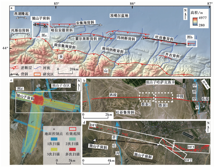
Fig. 1 Distribution of main reverse fault-anticline fold belts in the piedmont of the North Tianshan Mountains and the location of the study area.
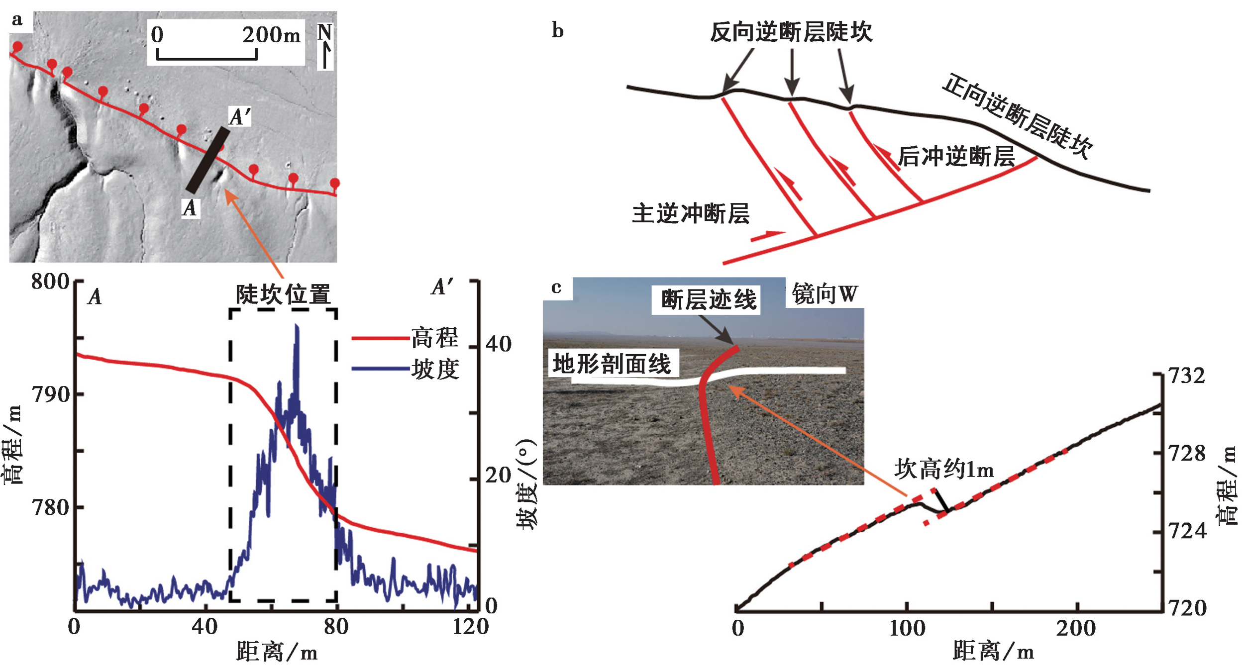
Fig. 2 Forward and backward thrust fault scarps.
| 控制断裂 | 断层陡坎坡度范围/(°) | 陡坎高度/m |
|---|---|---|
| 霍尔果斯背斜核部逆断裂(东段) | 9、10.5、13、17.5 | 7 |
| 20~27 | 10 | |
| 霍尔果斯背斜核部逆断裂(西段) | 6.5~17 | 0.7~1.8 |
| 14 | 8.2 | |
| 霍尔果斯背斜山前逆断裂 | 17~20.5 | 8.1 |
| 玛纳斯背斜山前断裂 | 11 | 4.3 |
| 15~21 | 4~5 | |
| 22 | 7~11.2 | |
| 吐谷鲁背斜核部逆断裂 | 12 | 2.5 |
| 10~20 | 6~10 | |
| 10~30 | 0.08~0.58 | |
| 7~20 | 0.3~0.6 | |
| 11.5 | 10.2 | |
| 10 | 11.6 | |
| 10~23 | 6.6 | |
| 23 | 3.9 | |
| 独山子背斜山前逆断裂 | 10~20 | 1.3~2.1 |
| 独山子背斜东端NW向剪切断裂带 | 5~18 | 0.9~1.4 |
Table1 The statistics of thrust fault scarp slope and height of the northern piedmont of the Tianshan Mountains(DENG Qi-dong et al., 2000)
| 控制断裂 | 断层陡坎坡度范围/(°) | 陡坎高度/m |
|---|---|---|
| 霍尔果斯背斜核部逆断裂(东段) | 9、10.5、13、17.5 | 7 |
| 20~27 | 10 | |
| 霍尔果斯背斜核部逆断裂(西段) | 6.5~17 | 0.7~1.8 |
| 14 | 8.2 | |
| 霍尔果斯背斜山前逆断裂 | 17~20.5 | 8.1 |
| 玛纳斯背斜山前断裂 | 11 | 4.3 |
| 15~21 | 4~5 | |
| 22 | 7~11.2 | |
| 吐谷鲁背斜核部逆断裂 | 12 | 2.5 |
| 10~20 | 6~10 | |
| 10~30 | 0.08~0.58 | |
| 7~20 | 0.3~0.6 | |
| 11.5 | 10.2 | |
| 10 | 11.6 | |
| 10~23 | 6.6 | |
| 23 | 3.9 | |
| 独山子背斜山前逆断裂 | 10~20 | 1.3~2.1 |
| 独山子背斜东端NW向剪切断裂带 | 5~18 | 0.9~1.4 |

Fig. 3 Flow diagram showing the extraction of the trace of the forward Hutubi fault scarp.
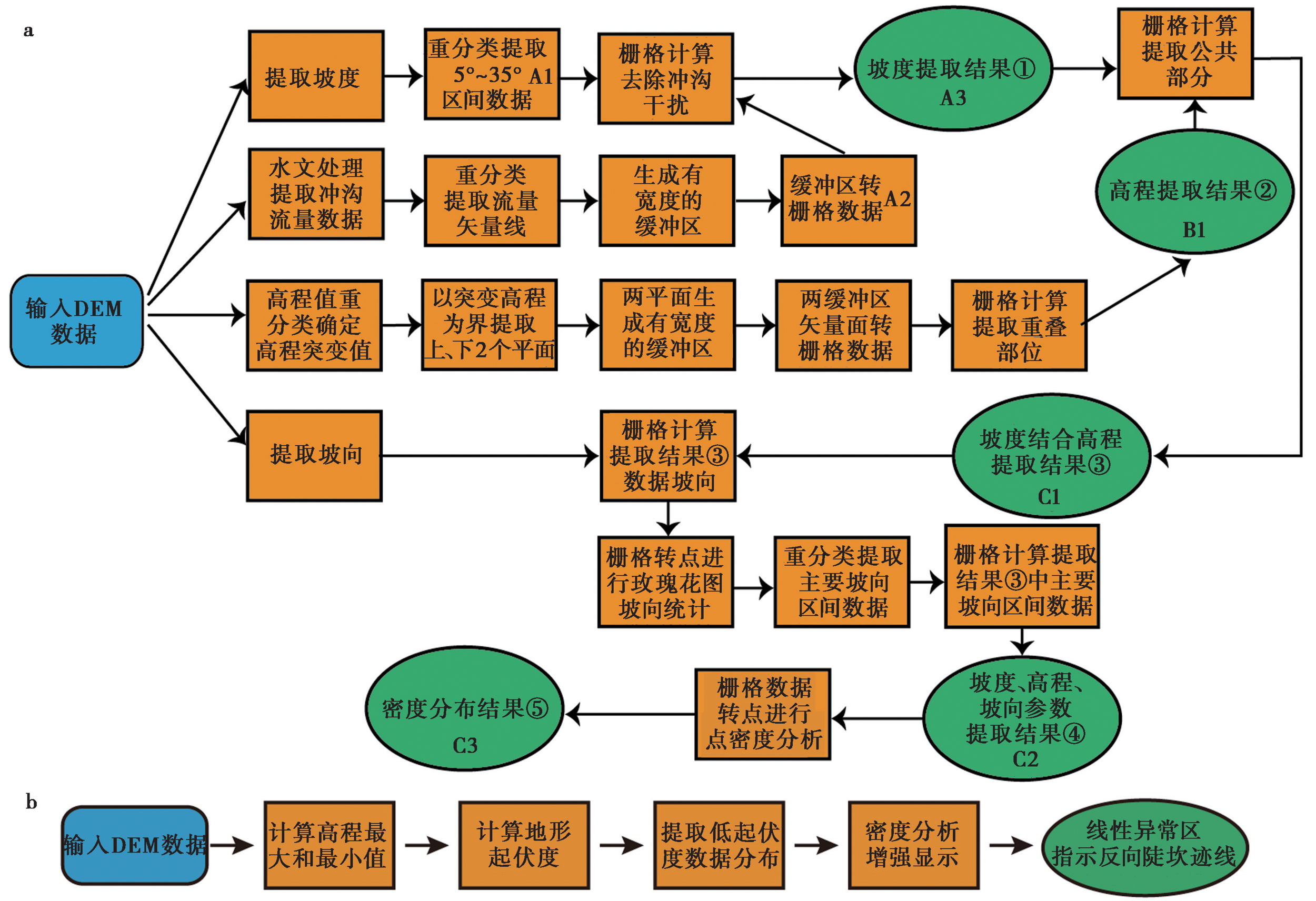
Fig. 4 The summary of modeling process.
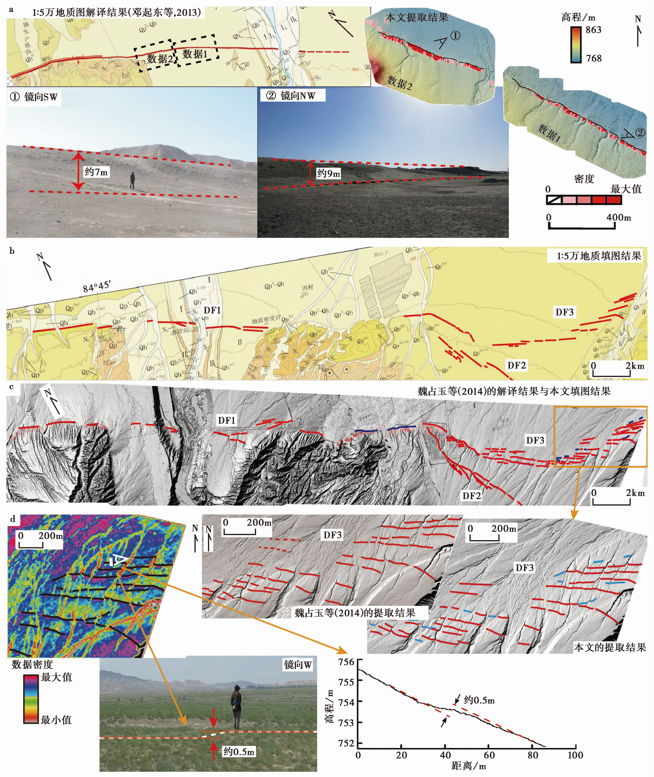
Fig. 5 Comparison of different extraction results and field verification.
| [1] | 邓起东, 冯先岳, 张培震, 等. 2000. 天山活动构造[M]. 北京: 地震出版社. |
| DENG Qi-dong, FENG Xian-yue, ZHANG Pei-zhen, et al. 2000. Active Tectonics in Tianshan Mountain[M]. Seismological Press, Beijing. (in Chinese) | |
| [2] |
魏占玉, 何宏林, 高伟, 等. 2014. 基于LiDAR数据开展活动断层填图的实验研究: 以新疆独山子背斜-逆冲断裂带为例[J]. 地震地质, 36(3): 794-813. doi: 10.3969/j.issn.0253-4967.2014.03.019.
DOI |
| WEI Zhan-yu, HE Hong-lin, GAO Wei, et al. 2014. Experiment study on geologic mapping of active tectonics based on LiDAR data: A case of Dushanzi anticline-reverse fault zone in Xinjiang[J]. Seismology and Geology, 36(3): 794-813. (in Chinese) | |
| [3] | 杨晓平. 1994. 新疆北天山活动逆断裂-褶皱带的变形、机制和大地震重复间隔研究[D]. 北京: 国家地震局地质研究所. |
| YANG Xiao-ping. 1994. Study on the deformation, kinematics and great earthquake recurrence interval of active thrust-and-fold belts in the North Tianshan Mountains[D]. Institute of Geology, China Earthquake Administration, Beijing. (in Chinese) | |
| [4] |
姚文倩, 刘静, Oskin M, 等. 2019. 利用R语言半自动化提取河流阶地: 以米家山黄河阶地为例[J]. 地震地质, 41(2): 363-376. doi: 10.3969/j.issn.0253-4967.2019.02.007.
DOI |
| YAO Wen-qian, LIU-ZENG Jing, Oskin M, et al. 2019. Application of semiautomatic extraction of fluvial terraces based on R language: An example from the Yellow River terraces at Mijia Shan[J]. Seismology and Geology, 41(2): 363-376. (in Chinese) | |
| [5] |
张玲, 杨晓平, 魏占玉, 等. 2014. 三维数据的二维可视化方法综述[J]. 地震地质, 36(1): 275-283. doi: 10.3969/j.issn.0253-4967.2014.02.023.
DOI |
| ZHANG Ling, YANG Xiao-ping, WEI Zhan-yu, et al. 2014. Overview of visualization methods of three dimensional topographic data[J]. Seismology and Geology, 36(1): 275-283. (in Chinese) | |
| [6] |
Bonetto S, Facello A, Ferrero A M, et al. 2015. A tool for semi-automatic linear feature detection based on DTM[J]. Computers and Geosciences, 75: 1-12.
DOI URL |
| [7] |
Chiba T, Hasi B. 2016. Ground surface visualization using red relief image map for a variety of map scales[J]. The International Archives of the Photogrammetry, Remote Sensing and Spatial Information Sciences, XLI-B2: 393-397.
DOI URL |
| [8] | Chiba T, Kaneta S I, Suzuki Y. 2008. Red relief image map: New visualization method for three dimensional data[J]. The International Archives of the Photogrammetry, Remote Sensing and Spatial Information Sciences, 37(B2): 1071-1076. |
| [9] |
Gannouni S, Gabtni H. 2015. Structural interpretation of lineaments by satellite image processing(Landsat TM)in the region of Zahret Medien(Northern Tunisia)[J]. Journal of Geographic Information System, 7(2): 119-127.
DOI URL |
| [10] |
Han L, Liu Z, Ning Y, et al. 2018. Extraction and analysis of geological lineaments combining a DEM and remote sensing images from the northern Baoji loess area[J]. Advances in Space Research, 62(9): 2480-2493.
DOI URL |
| [11] |
Jobe J A T, Philibosian B, Chupik C, et al. 2020. Evidence of previous faulting along the 2019 Ridgecrest, California, earthquake ruptures[J]. Bulletin of the Seismological Society of America, 110(4): 1427-1456.
DOI URL |
| [12] | Keller E A, Pinter N. 1996. Active Tectonics: Earthquakes, Uplift, and Landscape[M]. New Jersey, Prentice Hall. |
| [13] |
Kühni A, Pfiffner O A. 2001. The relief of the Swiss Alps and adjacent areas and its relation to lithology and structure: topographic analysis from a 250-m DEM[J]. Geomorphology, 41(4): 285-307.
DOI URL |
| [14] |
Lary D J, Alavi A H, Gandomi A H, et al. 2016. Machine learning in geosciences and remote sensing[J]. Geoscience Frontiers, 7(1): 3-10.
DOI URL |
| [15] |
Lin Z, Kaneda H, Mukoyama S, et al. 2013. Detection of subtle tectonic-geomorphic features in densely forested mountains by very high-resolution airborne LiDAR survey[J]. Geomorphology, 182(2): 104-115.
DOI URL |
| [16] | Liu Q, Zhang H, Li Y, et al. 2021. Effects of erosion and deposition on constraining vertical slip rates of thrust faults: A case study of the Minle-Damaying Fault in the North Qilian Shan, NE Tibetan plateau[J]. Frontiers in Earth Science, 9(205): 1-20. |
| [17] |
Maggiori E, Tarabalka Y, Charpiat G, et al. 2017. High-resolution aerial image labeling with convolutional neural networks[J]. IEEE Transactions on Geoscience and Remote Sensing, 55(12): 7092-7103.
DOI URL |
| [18] |
Masoud A A, Koike K. 2011. Auto-detection and integration of tectonically significant lineaments from SRTM DEM and remotely-sensed geophysical data[J]. Journal of Photogrammetry and Remote Sensing, 66(6): 818-832.
DOI URL |
| [19] | Mattéo L, Manighetti I, Tarabalka Y, et al. 2021. Automatic fault mapping in remote optical images and topographic data with deep learning[J]. Journal of Geophysical Research: Solid Earth, 126(4): e2020JB021269. |
| [20] |
Molnar P, Tapponnier P. 1975. Cenozoic tectonics of Asia: Effects of a continental collision: Features of recent continental tectonics in Asia can be interpreted as results of the India-Eurasia collision[J]. Science, 189(4201): 419-426.
PMID |
| [21] |
Msaddek M H, Moumni Y, Chenini I, et al. 2019. Applicability of developed algorithm for semi-automated extraction and morphotectonic interpretation of lineaments using remotely sensed data, southwestern Tunisia[J]. Remote Sensing in Earth Systems Sciences, 2(4): 292-307.
DOI |
| [22] |
Palamara D R, Dickson M E, Kennedy D M. 2007. Defining shore platform boundaries using airborne laser scan data: a preliminary investigation[J]. Earth Surface Processes and Landforms, 32(6): 945-953.
DOI URL |
| [23] |
Radaideh O M A, Grasemann B, Melichar R, et al. 2016. Detection and analysis of morphotectonic features utilizing satellite remote sensing and GIS: An example in SW Jordan[J]. Geomorphology, 275: 58-79.
DOI URL |
| [24] | Raj S K, Ahmed S A. 2014. Lineament extraction from Southern Chitradurga Schist Belt using Landsat TM, astergdem and geomatics techniques[J]. International Journal of Computer Applications, 93(12): 12-20. |
| [25] |
Sare R, Hilley G E, DeLong S B. 2018. Regional-scale detection of fault scarps and other tectonic landforms: Examples from Northern California[J]. Journal of Geophysical Research: Solid Earth, 124: 1016-1035.
DOI URL |
| [26] |
Soto-Pinto C, Arellano-Baeza A, Sánchez G. 2013. A new code for automatic detection and analysis of the lineament patterns for geophysical and geological purposes(ADALGEO)[J]. Computers & Geosciences, 57: 93-103.
DOI URL |
| [27] |
Stewart I S, Hancock P L. 1988. Normal fault zone evolution and fault scarp degradation in the Aegean region[J]. Basin Research, 1(3): 139-153.
DOI URL |
| [28] |
Su P, He H, Wei Z, et al. 2018. A new shortening rate across the Dushanzi anticline in the northern Tian Shan Mountains, China from lidar data and a seismic reflection profile[J]. Journal of Asian Earth Sciences, 163: 131-141.
DOI URL |
| [29] |
Tasar O, Tarabalka Y, Alliez P. 2019. Incremental learning for semantic segmentation of large-scale remote sensing data[J]. IEEE Journal of Selected Topics in Applied Earth Observations and Remote Sensing, 12(9): 3524-3537.
DOI |
| [30] |
Wei Z, He H, Hao H, et al. 2017. Automated mapping of landforms through the application of supervised classification to lidAR-derived DEMs and the identification of earthquake ruptures[J]. International Journal of Remote Sensing, 38(23): 7196-7219.
DOI URL |
| [31] | Yokoyama R, Shlrasawa M, Pike R J. 2002. Visualizing topography by openness: A new application of image processing to digital elevation models[J]. Photogrammetric Engineering & Remote Sensing, 68(3): 257-265. |
| [32] |
Zielke O, Klinger Y, Arrowsmith J R. 2015. Fault slip and earthquake recurrence along strike-slip faults: Contributions of high-resolution geomorphic data[J]. Tectonophysics, 638(1): 43-62.
DOI URL |
| [1] | YAO Sheng-hai, GAI Hai-long, YIN Xiang, LIU Wei, ZHANG Jia-qing, YUAN Jian-xin. TECTONIC GEOMORPHOLOGY AND QUATERNARY SLIP RATE OF THE XITIESHAN SECTION OF THE NORTHERN MARGIN FAULT OF QAIDAM BASIN [J]. SEISMOLOGY AND GEOLOGY, 2020, 42(6): 1385-1400. |
| [2] | WU Gui-ling, ZHU Cheng-yu, WANG Guo-can, ZHANG Pan. DEMARCATION OF THE GEOMORPHOLOGICAL BOUNDARIES OF SOUTHEASTERN TIBET: IMPLICATIONS FOR EXPANSION MECHANISMS OF THE PLATEAU EDGE [J]. SEISMOLOGY AND GEOLOGY, 2019, 41(2): 281-299. |
| [3] | XU Zhi-guo, LIANG Shan-shan, ZOU Li-ye, LIU Jing-guang. MECHANISM OF THE 2016 HUTUBI, XINJIANG, MS6.2 MAINSHOCK AND RELOCATION OF ITS AFTERSHOCK SEQUENCES [J]. SEISMOLOGY AND GEOLOGY, 2019, 41(1): 44-57. |
| [4] | AI Ming, BI Hai-yun, ZHENG Wen-jun, YIN Jin-hui, YUAN Dao-yang, REN Zhi-kun, CHEN Gan, LIU Jin-rui. USING UNMANNED AERIAL VEHICLE PHOTOGRAMMETRY TECHNOLOGY TO OBTAIN QUANTITATIVE PARAMETERS OF ACTIVE TECTONICS [J]. SEISMOLOGY AND GEOLOGY, 2018, 40(6): 1276-1293. |
| [5] | YANG Hai-bo, YANG Xiao-ping, HUANG Xiong-nan, HU Zong-kai. LATE QUATERNARY TECTONIC DEFORMATION AROUND THE HUJIATAI ANTICLINE ALONG THE EAST SEGMENT OF THE FODONGMIAO-HONGYAZI FAULT, NORTHERN QILIAN SHAN: AN INSIGHT ON THE SEISMOGENIC PATTERN OF 1609 HONGYAZI M7 1/4 EARTHQUAKE [J]. SEISMOLOGY AND GEOLOGY, 2018, 40(5): 980-998. |
| [6] | WANG Si-yu, AI Ming, WU Chuan-yong, LEI Qi-yun, ZHANG Hui-ping, REN Guang-xue, LI Chuan-you, REN Zhi-kun. APPLICATION OF DEM GENERATION TECHNOLOGY FROM HIGH RESOLUTION SATELLITE IMAGE IN QUANTITATIVE ACTIVE TECTONICS STUDY: A CASE STUDY OF FAULT SCARPS IN THE SOUTHERN MARGIN OF KUMISHI BASIN [J]. SEISMOLOGY AND GEOLOGY, 2018, 40(5): 999-1017. |
| [7] | WU Xi-yan, XU Xi-wei, YU Gui-hua, CHENG Jia, CHEN Gui-hua, AN Yan-fen, WANG Qi-xin. MAP PREPARATION OF EARTHQUAKE SURFACE RUPTURES IN THE NATIONAL EXPERIMENTAL FIELD OF EARTHQUAKE MONITORING AND PREDICTION IN SICHUAN AND YUNNAN PROVINCE [J]. SEISMOLOGY AND GEOLOGY, 2018, 40(1): 27-41. |
| [8] | HAN Xiao-ming, Liu Fang, ZHANG Fan, CHEN Li-feng, LI Juan, LI Shuan-hu, YANG Hong-ying. 3D P-WAVE VELOCITY STRUCTURE AT THE NORTHEASTERN MARGIN OF ORDOS BLOCK [J]. SEISMOLOGY AND GEOLOGY, 2018, 40(1): 215-231. |
| [9] | XU Wei, LIU Zhi-cheng, YUAN Zhao-de, GAO Zhan-wu, YANG Yuan-yuan. RIVER GEOMORPHIC PARAMETERS OF THE HUASHAN PIEDMONT AND THEIR TECTONIC IMPLICATIONS [J]. SEISMOLOGY AND GEOLOGY, 2017, 39(6): 1316-1335. |
| [10] | BI Hai-yun, ZHENG Wen-jun, ZENG Jiang-yuan, YU Jing-xing, REN Zhi-kun. APPLICATION OF SFM PHOTOGRAMMETRY METHOD TO THE QUANTITATIVE STUDY OF ACTIVE TECTONICS [J]. SEISMOLOGY AND GEOLOGY, 2017, 39(4): 656-674. |
| [11] | AI Sheng, ZHANG Bo, FAN Chun, WANG Yang. SURFACE TRACKS AND SLIP RATE OF THE FAULT ALONG THE SOUTHERN MARGIN OF THE WUWEI BASIN IN THE LATE QUATERNARY [J]. SEISMOLOGY AND GEOLOGY, 2017, 39(2): 408-422. |
| [12] | ZHANG Guang-wei, ZHANG Hong-yan, SUN Chang-qing. MECHANISM OF THE 2015 PISHAN, XINJIANG, MS6.5 MAINSHOCK AND RELOCATION OF ITS AFTERSHOCK SEQUENCES [J]. SEISMOLOGY AND GEOLOGY, 2016, 38(3): 711-720. |
| [13] | SUN Xin-zhe, TANG Sheng-quan. THE DEVELOPMENT OF OPTICAL REMOTE SENSING TECHNOLOGY AND ITS APPLICATION TO THE ACTIVE TECTONICS RESEARCH [J]. SEISMOLOGY AND GEOLOGY, 2016, 38(1): 211-220. |
| [14] | HUANG Bei, ZHANG Pei-zhen, ZHANG Dong-li, LI Xiao-jun. the faulting characteristics of 2008 wenchuan ms8.0 earthquake and its relation with strong ground motion [J]. SEISMOLOGY AND GEOLOGY, 2015, 37(4): 1055-1069. |
| [15] | LI An, YANG Xiao-ping, Yiliyaer. THE RUPTURE MODEL AND TIME SERIES OF PALEOEARTHQUAKES OF THE HEJING THRUST FAULT-FOLD BELT IN THE NORTH MARGIN OF THE YANQI BASIN [J]. SEISMOLOGY AND GEOLOGY, 2015, 37(3): 661-674. |
| Viewed | ||||||
|
Full text |
|
|||||
|
Abstract |
|
|||||
