SEISMOLOGY AND GEOLOGY ›› 2023, Vol. 45 ›› Issue (2): 517-535.DOI: 10.3969/j.issn.0253-4967.2023.02.013
Previous Articles Next Articles
ZHOU Ming( ), DUAN Yong-hong*(), TAN Yu-juan, QIU Yong
Revised:2022-10-24
Online:2023-04-20
Published:2023-05-18
周铭(), 段永红*(), 檀玉娟, 邱勇
通讯作者:
*段永红, 男, 1963年生, 研究员, 博士, 长期从事地球内部结构及动力学, 地震层析成像、火山地震学等研究工作, E-mail: 作者简介:周铭, 女, 1987年生, 2014年于中国地质大学(北京)获得地球物理学专业硕士学位, 工程师, 主要从事短周期密集台阵探测工作, E-mail: zhouming@gec.ac.cn。
基金资助:CLC Number:
ZHOU Ming, DUAN Yong-hong, TAN Yu-juan, QIU Yong. THE 3-D SHALLOW VELOCITY STRUCTURE OF THE MIDDLE-NORTH SECTION OF THE DONGPU DEPRESSION DERIVED FROM DENSE ARRAY OBSERVATIONS OF AMBIENT NOISE[J]. SEISMOLOGY AND GEOLOGY, 2023, 45(2): 517-535.
周铭, 段永红, 檀玉娟, 邱勇. 基于密集台阵的东濮凹陷中北段浅层速度结构[J]. 地震地质, 2023, 45(2): 517-535.
Add to citation manager EndNote|Ris|BibTeX
URL: https://www.dzdz.ac.cn/EN/10.3969/j.issn.0253-4967.2023.02.013

Fig. 1 Structural map of Dongpu depression(after SHI Fa-jian, 2012)(a). Distribution map of topographic and historical earthquake in the study area(b).
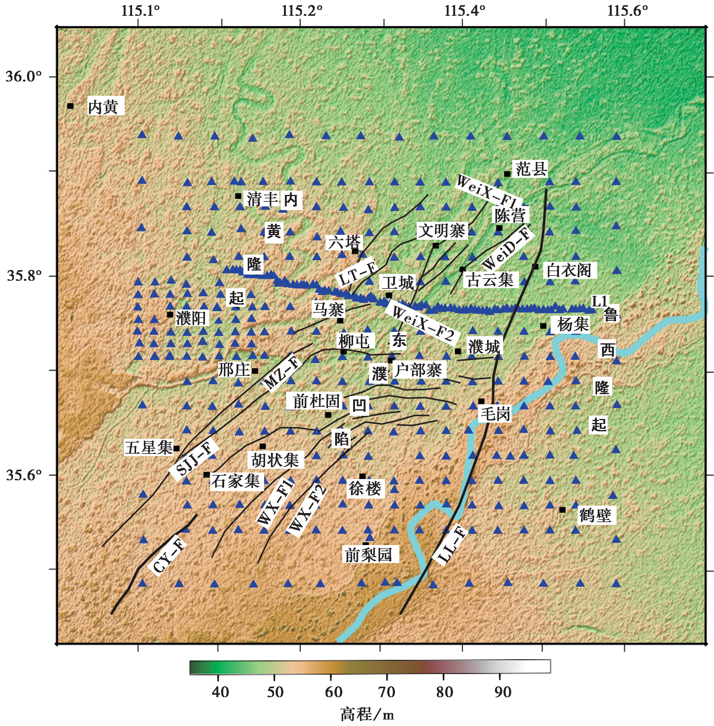
Fig. 2 The map of topographic and station locations in the study region.

Fig. 3 Cross-correlation function with 1~4s band-pass filter.
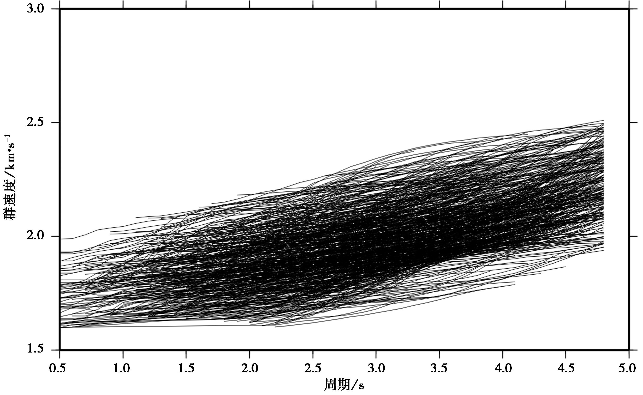
Fig. 4 Group velocity dispersion curves in the 0.5~5s period band.
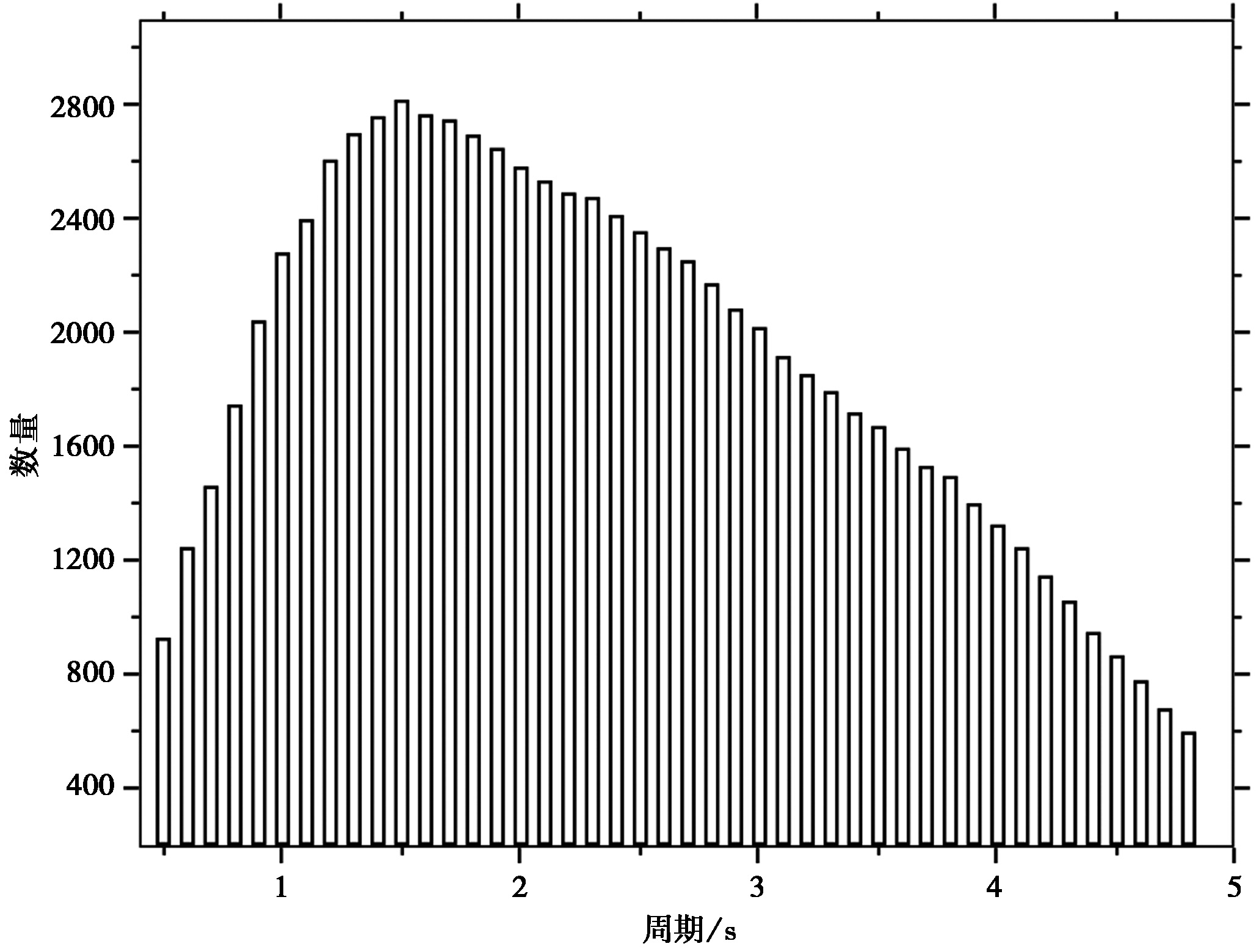
Fig. 5 The number dispersion curves at different period.
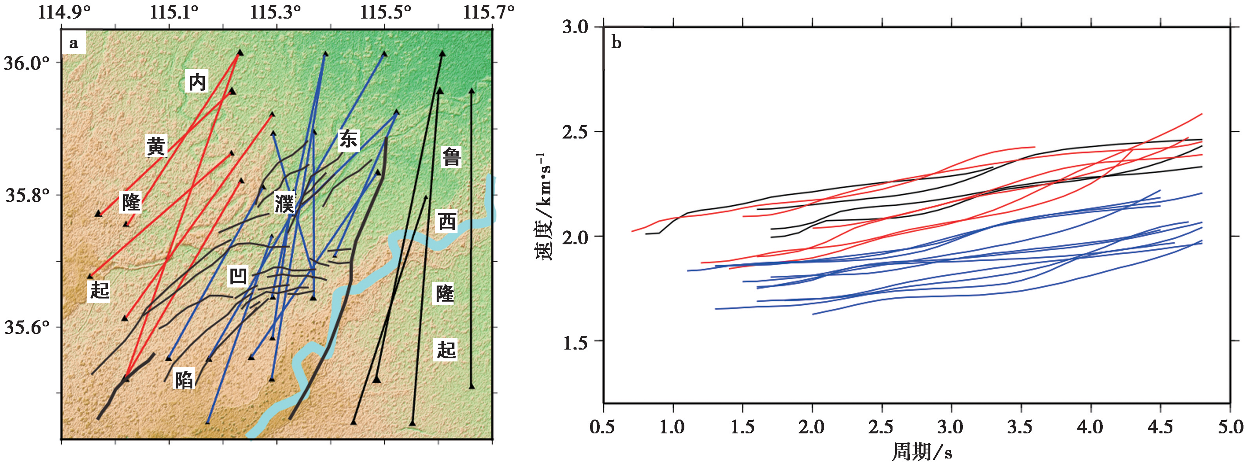
Fig. 6 Examples of interstation paths for the group velocity measurements.
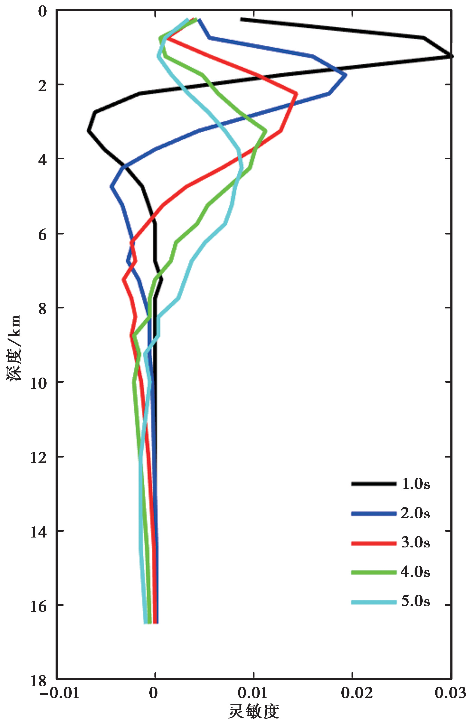
Fig. 7 Depth sensitivity kernels for group velocity at six periods: 1.0s, 2.0s, 3.0s, 4.0s and 5.0s.
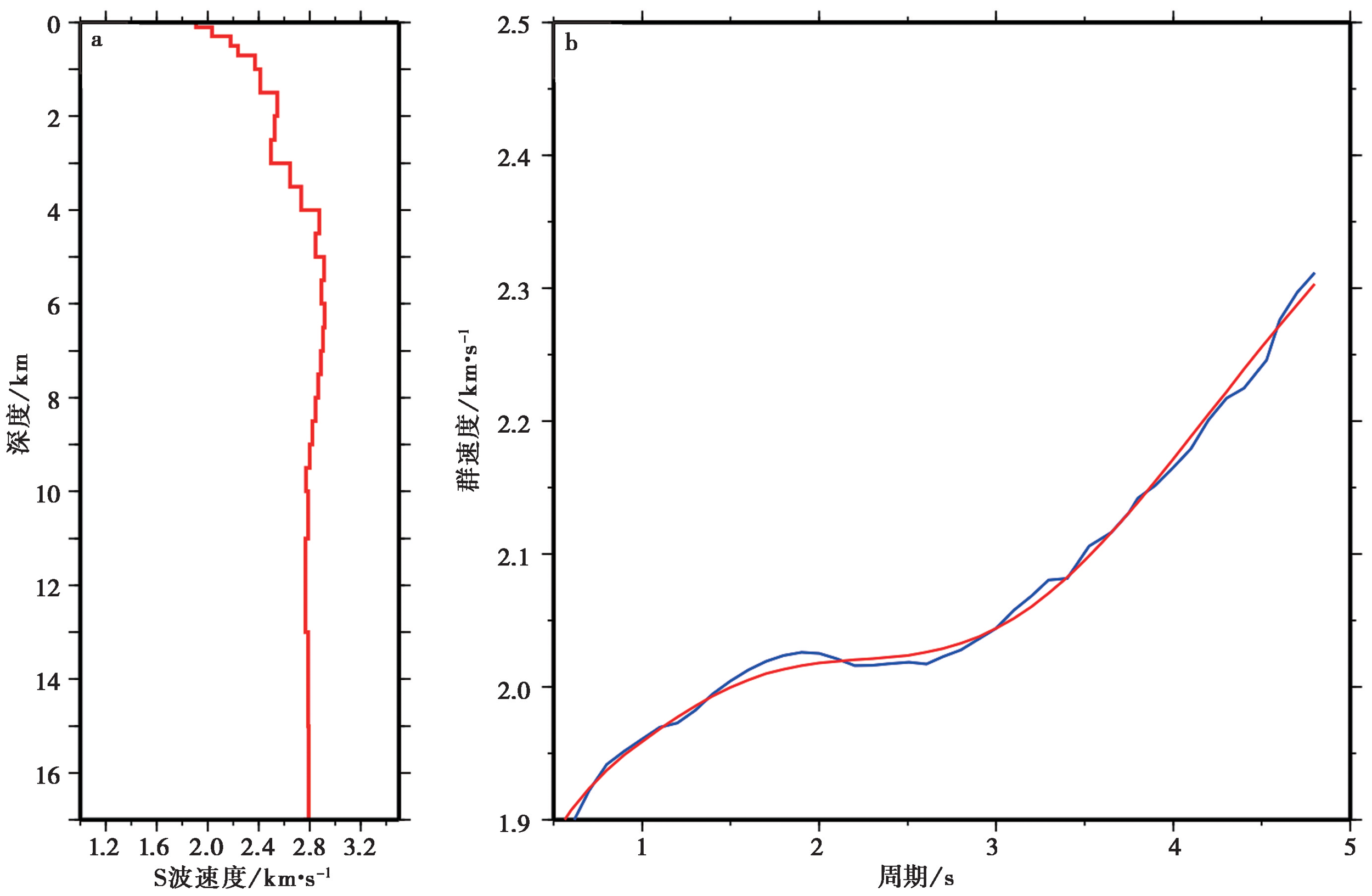
Fig. 8 1-D velocity model and dispersion curve matching.
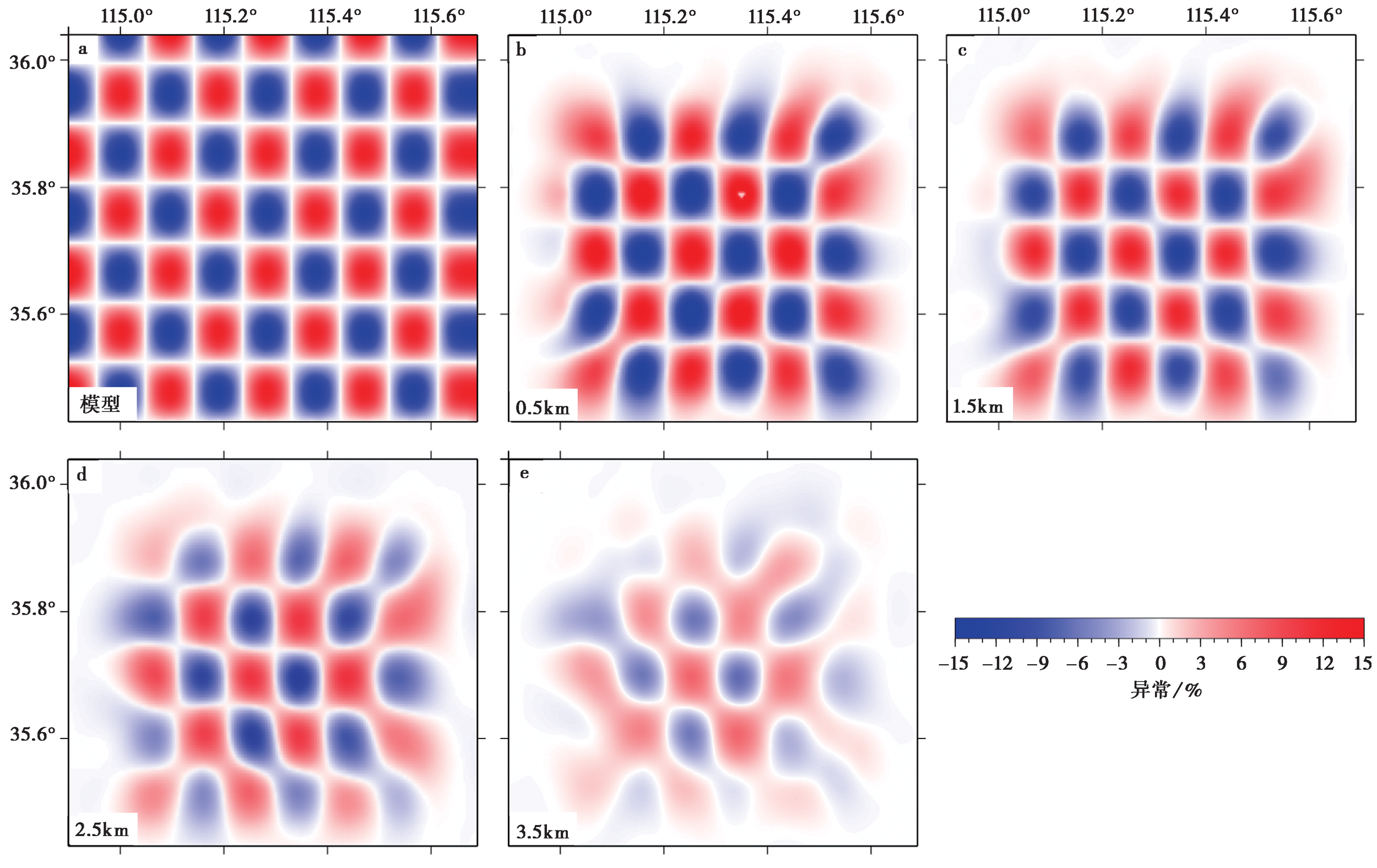
Fig. 10 Checkerboard model and checkerboard resolution tests of the inversion results.
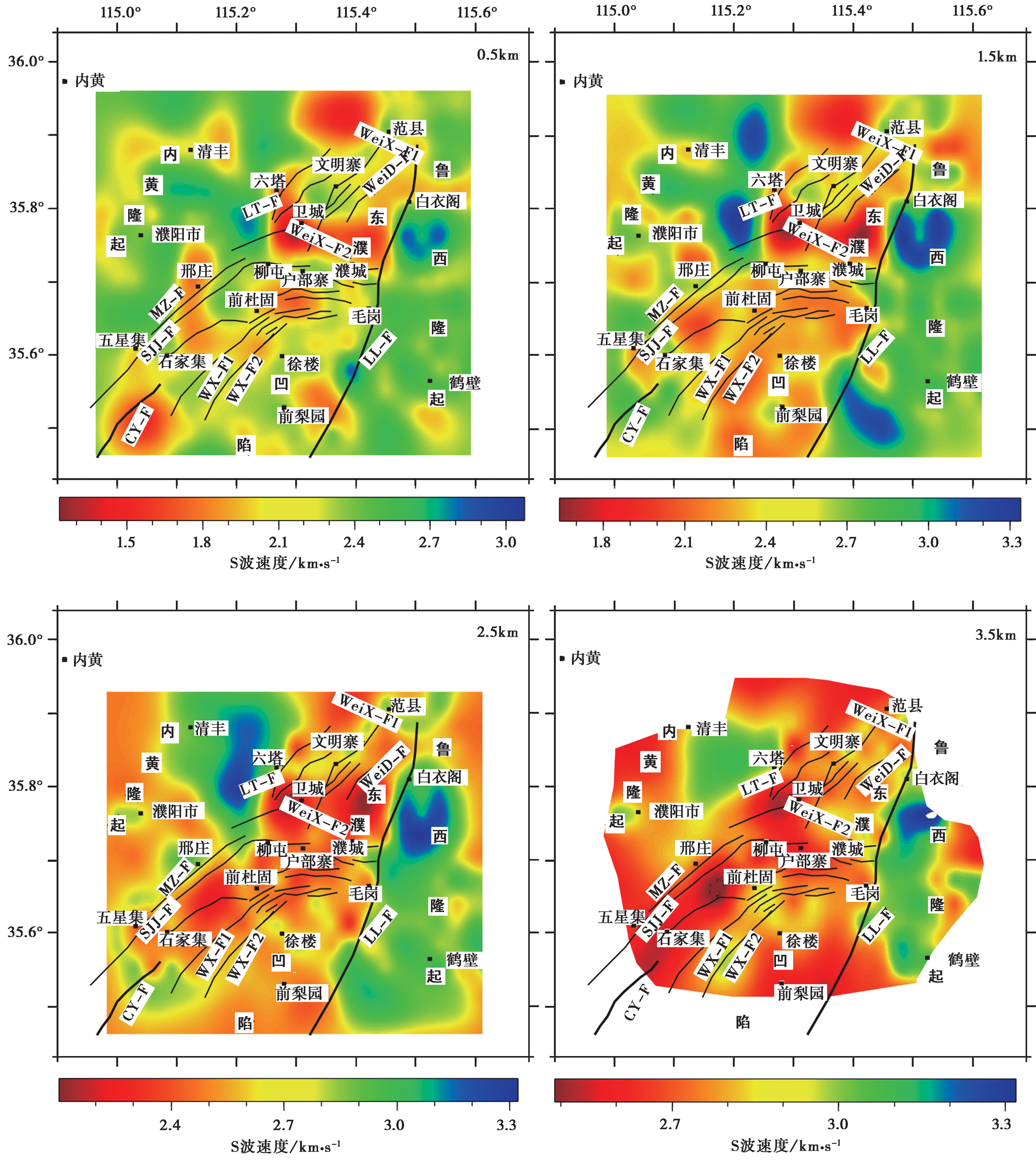
Fig. 11 The distribution of S-wave velocity at different depths.
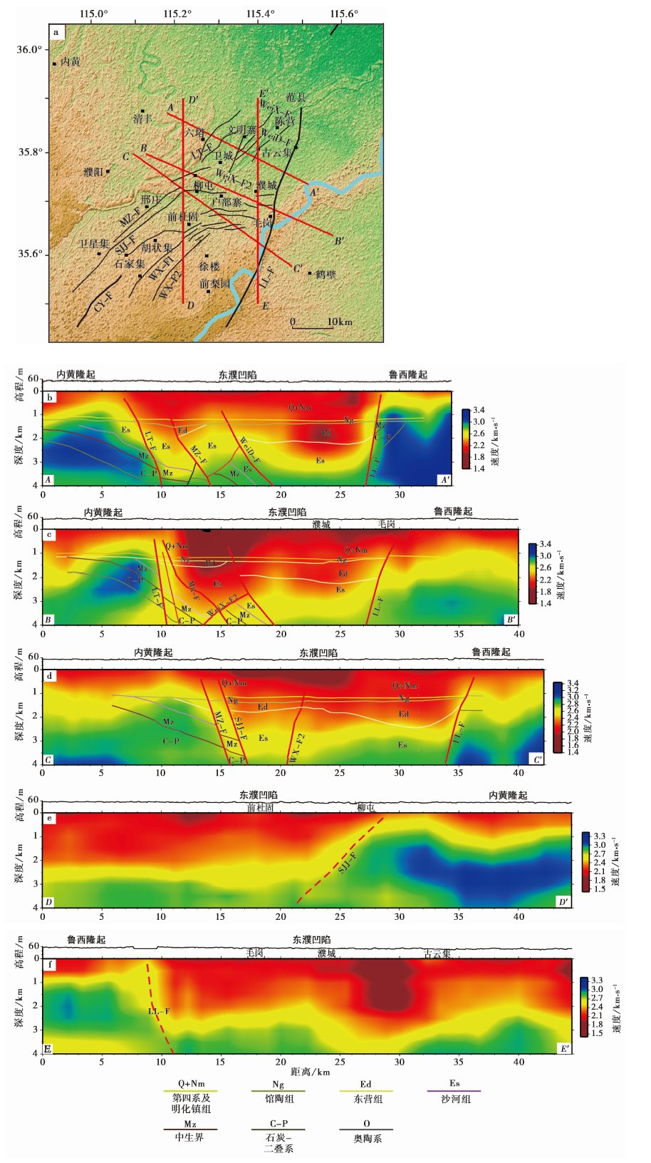
Fig. 12 The velocity distribution of AA', BB', CC', DD' and EE'.
| [1] | 陈亚红, 张军, 董春勇, 等. 2020. 濮阳小震集中区地震丛集特征分析[J]. 地震地磁观测与研究, 41(2): 51-56. |
| CHEN Ya-hong, ZHANG Jun, DONG Chun-yong, et al. 2020. Study on the characteristics of earthquake clustering in small earthquake concentrated area of Puyang[J]. Seismological and Geomagnetic Observation and Research, 41(2): 51-56. (in Chinese) | |
| [2] | 程岳宏, 于兴河, 韩宝清, 等. 2010. 东濮凹陷北部古近系沙三段地球化学特征及地质意义[J]. 中国地质, 37(2): 357-366. |
| CHENG Yue-hong, YU Xing-he, HAN Bao-qing, et al. 2010. Geochemical characteristics of the 3rd Member of Paleogene Shahejie Formation in Dongpu depression and their geological implications[J]. Geology in China, 37(2): 357-366. (in Chinese) | |
| [3] | 戴骜鹏. 2014. 焦作地区第四纪主要断层研究[D]. 兰州: 中国地震局兰州地震研究所:15-46. |
| DAI Ao-peng. 2014. Study of major Quaternary faults in Jiaozuo area[D]. China Earthquake Administration Lanzhou Institute of Seismology, Lanzhou: 15-46. (in Chinese) | |
| [4] | 段永红, 王夫运, 张先康, 等. 2016. 华北克拉通中东部地壳三维速度结构模型(HBCrust1.0)[J]. 中国科学(D辑), 46(6): 845-856. |
|
DUAN Yong-hong, WANG Fu-yun, ZHANG Xian-kang, et al. 2016. Three dimensional crustal velocity structure model of the middle-eastern North China Craton (HBCrust1.0)[J]. Science in China (Ser D), 59(7): 1477-1488.
DOI URL |
|
| [5] | 葛建党. 2001. 郯庐断裂在渤中凹陷的构造特征与油气成藏的关系[J]. 海洋石油, 1(4): 14-20. |
| GE Jian-dang. 2001. The tectonic character of Tanlu fault(TLF)and the relation between TLF and hydrocarbon accumulation in Bozhong sag[J]. Offshore Oil, 1(4): 14-20. (in Chinese) | |
| [6] | 何登发, 单帅强, 张煜颖, 等. 2018. 雄安新区的三维地质结构: 来自反射地震资料的约束[J]. 中国科学(D辑), 48(9): 1207-1222. |
|
HE Deng-fa, SHAN Shuai-qiang, ZHANG Yu-ying, et al. 2018. 3-D geologic architecture of Xiong’an new area: constraints from seismicreflection data[J]. Science in China(Ser D), 61(8): 1007-1022.
DOI |
|
| [7] | 姜磊, 徐志萍, 方盛明, 等. 2018. 利用重震资料研究豫北及邻区地壳结构特征与地震分布[J]. 地震地质, 40(2): 323-336. |
| JIANG Lei, XU Zhi-ping, FANG Sheng-ming, et al. 2018. Deep structure of northern Henan Province and adjacent areas derived from gravity and seismic sounding data in relation to distribution of earthquakes[J]. Seismology and Geology, 40(2): 323-336. (in Chinese) | |
| [8] | 李玲利, 黄显良, 姚华建, 等. 2020. 合肥市地壳浅部三维速度结构及城市沉积环境初探[J]. 地球物理学报, 63(9): 3307-3323. |
| LI Ling-li, HUANG Xian-liang, YAO Hua-jian, et al. 2020. Shallow shear wave velocity structure from ambient noise tomography in Hefei city and its implication for urban sedimentary environment[J]. Chinese Journal of Geophysics, 63(9): 3307-3323. (in Chinese) | |
| [9] | 马宝军, 漆家福, 于福生. 2017. 东濮凹陷构造变形的物理模拟研究[J]. 地球学报, 38(3): 430-438. |
| MA Bao-jun, QI Jia-fu, YU Fu-sheng. 2017. An analysis of physical modeling of tectonic deformation in Dongpu Sag[J]. Acta Geoscientica Sinica, 38(3): 430-438. (in Chinese) | |
| [10] | 尚墨翰. 2014. 东濮凹陷构造-沉积演化与油气成藏的关系[J]. 油气地质与采收率, 21(4): 50-53. |
| SHANG Mo-han. 2014. Relationship between structural-depositional evolution and oil-gas accumulation in Dongpu sag[J]. Petroleum Geology and Recovery Efficiency, 21(4): 50-53. (in Chinese) | |
| [11] | 施发剑. 2012. 兰聊断裂带的形成与演化[D]. 北京: 中国地质大学:1-60. |
| SHI Fa-jian. 2012. The formation and evolution of Lanliao fault zone[D]. Beijing: China University of Geosciences:1-60. (in Chinese) | |
| [12] | 唐民安, 王华. 2008. 东濮凹陷古近纪断裂活动的幕式特征及控盆作用[J]. 海洋地质与第四纪地质, 28(3): 55-59. |
| TANG Min-an, WANG Hua. 2008. Episodic characteristics of faults and their effects on sedimentary and structural evolution during Paleogene: a case study of Dongpu depression[J]. Marine Geology & Quaternary Geology, 28(3): 55-59. (in Chinese) | |
| [13] | 余海波, 程秀申, 徐田武, 等. 2020. 东濮凹陷古近纪盆地结构控烃控藏特征[J]. 现代地质, 34(6): 1119-1131. |
| YU Hai-bo, CHENG Xiu-shen, XU Tian-wu, et al. 2020. Characteristics about hydrocarbon accumulation controlled by structure in Paleogene of Dongpu sag[J]. Geoscience, 34(6): 1119-1131. | |
| [14] | 于磊, 张健, 高玲举, 等. 2017. 鲁西隆起重磁异常特征及其构造活动性分析[J]. 地震学报, 39(5): 694-707. |
| YU Lei, ZHANG Jian, GAO Ling-ju, et al. 2017. Gravity-magnetic anomalies and tectonic activities in Luxi uplift[J]. Acta Seismologica Sinica, 39(5): 694-707. (in Chinese) | |
| [15] | 张克鑫, 漆家福, 赵衍彬, 等. 2007. 新生代东濮凹陷构造特征及其演化[J]. 新疆石油地质, 28(6): 714-717. |
| ZHANG Ke-xin, QI Jia-fu, ZHAO Yan-bin, et al. 2007. Structure and evolution of Cenozoic in Dongpu sag[J]. Xinjiang Petroleum Geology, 28(6): 714-717. (in Chinese) | |
| [16] | 张亚敏, 吕延仓, 徐林丽, 等. 2000. 东濮凹陷兰聊断裂带构造演化与油气勘探[J]. 石油与天然气地质, 21(1): 57-60. |
| ZHANG Ya-min, LÜ Yan-cang, XU Lin-li, et al. 2000. Structural evolution and hydrocarbon exploration of Lanliao fault belt in Dongpu depression[J]. Oil & Gas Geology, 21(1): 57-60. (in Chinese) | |
| [17] | 郑建常, 吕子强, 许萍, 等. 2013. 濮阳小震集中区发震机理分析与讨论[J]. 中国地震, 29(1): 11-25. |
| ZHENG Jian-chang, LÜ Zi-qiang, XU Ping, et al. 2013. Analyses and discussion on mechanism of clustered microearthquakes in Puyang, Henan Province[J]. Earthquake Research in China, 29(1): 11-25. (in Chinese) | |
| [18] |
周新科, 许化政. 2007. 东濮凹陷地质特征研究[J]. 石油学报, 28(5): 20-26.
DOI |
| ZHOU Xin-ke, XU Hua-zheng. 2007. Discussion on geological features of Dongpu depression[J]. Acta Pretrolei Sinica, 28(5): 20-26. (in Chinese) | |
| [19] |
左银辉, 唐世林, 张旺, 等. 2017. 东濮凹陷新生代构造-热历史研究[J]. 地学前缘, 24(3): 149-156.
DOI |
| ZUO Yin-hui, TANG Shi-lin, ZHANG Wang, et al. 2017. Cenozoic thermal history of the Dongpu sag, Bohai Bay Basin[J]. Earth Science Frontiers, 24(3): 149-156. (in Chinese) | |
| [20] |
Bensen G D, Ritzwoller M H, Barmin M P, et al. 2007. Processing seismic ambient noise data to obtain reliable broad-band surface wave dispersion measurements[J]. Geophysical Journal International, 169(3): 1239-1260.
DOI URL |
| [21] | Brocher T M. 2005. Empirical relations between elastic wave speeds and density in the Earth’s crust[J]. Bulletin of the Seismological Society of America, 95(6): 2081-2092. |
| [22] |
Fang H J, Yao H J, Zhang H J, et al. 2015. Direct inversion of surface wave dispersion for three-dimensional shallow crustal structure based on ray tracing: methodology and application[J]. Geophysical Journal International, 201(3): 1251-1263.
DOI URL |
| [23] |
Flores-Estrella H, Yussim S, Lomnitz C. 2007. Seismic response of the Mexico City Basin: A review of twenty[J]. Natural Hazards, 40(2): 357-372.
DOI URL |
| [24] |
Herrmann R B. 2013. Computer programs in seismology: An evolving tool for instruction and research[J]. Seismological Research Letters, 84(6): 1081-1088.
DOI URL |
| [25] |
Huang Y C, Yao H J, Huang B S, et al. 2010. Phase velocity variation at periods of 0.5-3 seconds in the Taipei Basin of Taiwan from correlation of ambient seismic noise[J]. Bulletin of the Seismological Society of America, 100(5A): 2250-2263.
DOI URL |
| [26] |
Li C, Yao H J, Fang H J, et al. 2016. 3-D near-surface shear-wave velocity structure from ambient-noise tomography and borehole data in the Hefei urban area, China[J]. Seismological Research Letters, 87(4): 882-892.
DOI URL |
| [27] | Li C, Yao H J, Yang Y Y, et al. 2020. 3-D shear wave velocity structure in the shallow crust of the Tanlu fault zone in Lujiang, Anhui, and adjacent areas, and its tectonic implications[J]. Earth and Planetary Physics, 4(2): 1-12. |
| [28] |
Li H Y, Su W, Wang C, et al. 2009. Ambient noise Rayleigh wave tomography in western Sichuan and eastern Tibet[J]. Earth and Planetary Science Letters, 282(1-4): 201-211.
DOI URL |
| [29] | Li G L, Yang Y J, Niu F L, et al. 2021. 3-D sedimentary structures beneath southeastern Australia constrained by passive seismic array data[J]. Journal of Geophysical Research: Solid Earth, 126(2): e2020JB019998. |
| [30] |
Lin F C, Li D Z, Clayton R W, et al. 2013. High-resolution 3D shallow crustal structure in Long Beach, California: Application of ambient noise tomography on a dense seismic array[J]. Geophysics, 78(4): Q45-Q56.
DOI URL |
| [31] |
Rawlinson N, Sambridge M. 2004. Wave front evolution in strongly heterogeneous layered media using the fast marching method[J]. Geophysical Journal International, 156(3): 631-647.
DOI URL |
| [32] |
Yao H J, van der Hilst R D, de Hoop M V. 2006. Surface-wave array tomography in SE Tibet from ambient seismic noise and two-station analysis-I. Phase velocity maps[J]. Geophysical Journal International, 166(2): 732-744.
DOI URL |
| [33] | Yao H J, Gouedard P, McGuire J, et al. 2011. Structure of young East Pacific Rise lithosphere from ambient noise correlation analysis of fundamental- and higher-mode Scholte-Rayleigh waves[J]. Comptes Rendus Geoscience, 343(8-9): 571-583. |
| [34] |
Zhou M, Tian X F, Wang F Y, et al. 2018. Shallow velocity structure of the Luoyang Basin derived from dense array observations of urban ambient noise[J]. Earthquake Science, 31(S1): 252-261.
DOI URL |
| [1] | GU Qin-ping, KANG Qing-qing, ZHANG Peng, MENG Ke, WU Shan-shan, LI Zheng-kai, WANG Jun-fei, HUANG Qun, JIANG Xin, LI Da-hu. RAYLEIGH WAVE PHASE VELOCITY AND AZIMUTHAL ANISOTROPY OF THE MIDDLE-SOUTHERN SEGMENT OF THE TAN-LU FAULT ZONE AND ADJACENT REGIONS FROM AMBIENT NOISE TOMOGRAPHY [J]. SEISMOLOGY AND GEOLOGY, 2020, 42(5): 1129-1152. |
| [2] | XIONG Cheng, XIE Zu-jun, ZHENG Yong, XIONG Xiong, AI San-xi, XIE Ren-xian. RAYLEIGH WAVE TOMOGRAPHY IN THE CRUST AND UPPER MANTLE OF THE DABIE-TANLU OROGENIC ZONE [J]. SEISMOLOGY AND GEOLOGY, 2019, 41(1): 1-20. |
| Viewed | ||||||
|
Full text |
|
|||||
|
Abstract |
|
|||||
