SEISMOLOGY AND GEOLOGY ›› 2023, Vol. 45 ›› Issue (4): 914-935.DOI: 10.3969/j.issn.0253-4967.2023.04.007
Previous Articles Next Articles
ZHOU Jie-yuan( ), ZHOU Qing*(), RAN Hong-liu
Received:2022-09-01
Revised:2022-12-08
Online:2023-08-20
Published:2023-09-20
周介元(), 周庆*(), 冉洪流
通讯作者:
*周庆, 男, 1963年生, 博士, 研究员, 主要研究方向为地震活动性与危险性分析, E-mail: zqcsb@163.com。
作者简介:基金资助:ZHOU Jie-yuan, ZHOU Qing, RAN Hong-liu. THE ANALYSIS OF THE STARTING YEAR AND THE COM-PLETENESS OF SEISMIC RECORDS FOR EARTHQUAKES WITH MAGNITUDES M≥7 IN THE BORDER REGION OF SICHUAN, YUNNAN AND TIBET[J]. SEISMOLOGY AND GEOLOGY, 2023, 45(4): 914-935.
周介元, 周庆, 冉洪流. 川滇藏交界地区M≥7地震记载的起始年代与资料完整性分析[J]. 地震地质, 2023, 45(4): 914-935.
Add to citation manager EndNote|Ris|BibTeX
URL: https://www.dzdz.ac.cn/EN/10.3969/j.issn.0253-4967.2023.04.007
| 地方 | 汛台 | 设置时间 | 备注 | |
|---|---|---|---|---|
| 打箭炉地方 (设有粮台) | 章谷汛(把总汛) | 北路 | 乾隆平定大小金川后设 | 今四川丹巴县章谷镇 |
| 噶达汛(大汛) | 雍正八年(1730年) | 今四川道孚县 | ||
| 角洛汛(外委汛) | 雍正四年(1726年) | |||
| 甘孜汛(把总汛,嘉庆时改设麻书汛) | 乾隆二年(1737年) | 今四川甘孜县 | ||
| 折多汛(外委汛) | 南路 | 今四川康定县西南五十里 | ||
| 里塘地方 (设有粮台) | 中渡汛(外委汛) | 康熙五十八年(1719年)设渡,雍正四年(1726年)设汛 | 今四川雅江县 | |
| 拨浪工汛(外委汛) | 乾隆十三年(1748年) | 今雅砻江以西, 四川理塘县东北 | ||
| 火竹卡汛(把总汛) | ||||
| 理塘汛(把总汛) | 今四川理塘县 | |||
| 巴塘地方 (设有粮台) | 巴塘汛(大汛) | 乾隆十三年(1748年) | 今四川巴塘县 | |
| 竹巴笼汛(外委汛) | 今四川巴塘县竹巴笼乡 | |||
| 江卡地方 | 江卡汛(把总汛) | 雍正七年(1729年) | 今西藏芒康县 | |
| 黎树汛(外委汛) | 今西藏芒康县西北 | |||
| 石板沟汛(把总汛) | ||||
| 乍丫地方 | 阿足汛(外委汛) | 乾隆十一年(1746年) | 今西藏察雅县以南 | |
| 乍丫汛(把总汛) | 今西藏察雅县 | |||
| 昂地汛(把总汛) | 今西藏察雅县以东 | |||
| 察木多地方 (设有粮台) | 察木多汛(大汛) | 乾隆十一年(1746年) | 今西藏昌都县 | |
| 硕般多地方 | 硕般多汛(大汛) | 乾隆十三年(1748年) | 今西藏洛隆县硕都镇 | |
| 拉里地方 (设有粮台) | 拉里汛(把总汛) | 乾隆十三年(1748年) | 今西藏嘉黎县 | |
| 江达地方 | 江达汛(外委汛) | 乾隆十三年(1748年) | 今西藏工布江达县 | |
Table 1 Statistical results of Tang-Xun setting on road from Sichuan to Tibet in the early Qing Dynasty(LI Yan-jun, 2013)
| 地方 | 汛台 | 设置时间 | 备注 | |
|---|---|---|---|---|
| 打箭炉地方 (设有粮台) | 章谷汛(把总汛) | 北路 | 乾隆平定大小金川后设 | 今四川丹巴县章谷镇 |
| 噶达汛(大汛) | 雍正八年(1730年) | 今四川道孚县 | ||
| 角洛汛(外委汛) | 雍正四年(1726年) | |||
| 甘孜汛(把总汛,嘉庆时改设麻书汛) | 乾隆二年(1737年) | 今四川甘孜县 | ||
| 折多汛(外委汛) | 南路 | 今四川康定县西南五十里 | ||
| 里塘地方 (设有粮台) | 中渡汛(外委汛) | 康熙五十八年(1719年)设渡,雍正四年(1726年)设汛 | 今四川雅江县 | |
| 拨浪工汛(外委汛) | 乾隆十三年(1748年) | 今雅砻江以西, 四川理塘县东北 | ||
| 火竹卡汛(把总汛) | ||||
| 理塘汛(把总汛) | 今四川理塘县 | |||
| 巴塘地方 (设有粮台) | 巴塘汛(大汛) | 乾隆十三年(1748年) | 今四川巴塘县 | |
| 竹巴笼汛(外委汛) | 今四川巴塘县竹巴笼乡 | |||
| 江卡地方 | 江卡汛(把总汛) | 雍正七年(1729年) | 今西藏芒康县 | |
| 黎树汛(外委汛) | 今西藏芒康县西北 | |||
| 石板沟汛(把总汛) | ||||
| 乍丫地方 | 阿足汛(外委汛) | 乾隆十一年(1746年) | 今西藏察雅县以南 | |
| 乍丫汛(把总汛) | 今西藏察雅县 | |||
| 昂地汛(把总汛) | 今西藏察雅县以东 | |||
| 察木多地方 (设有粮台) | 察木多汛(大汛) | 乾隆十一年(1746年) | 今西藏昌都县 | |
| 硕般多地方 | 硕般多汛(大汛) | 乾隆十三年(1748年) | 今西藏洛隆县硕都镇 | |
| 拉里地方 (设有粮台) | 拉里汛(把总汛) | 乾隆十三年(1748年) | 今西藏嘉黎县 | |
| 江达地方 | 江达汛(外委汛) | 乾隆十三年(1748年) | 今西藏工布江达县 | |
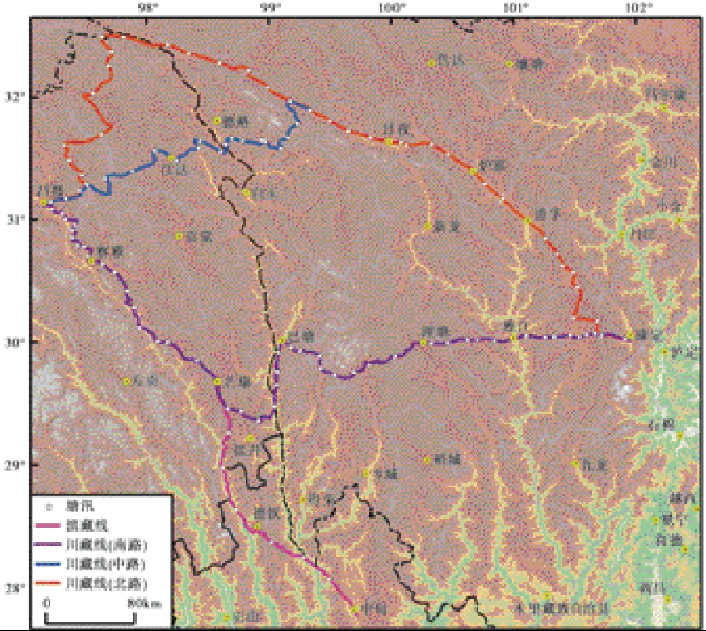
Fig. 1 The Road routine from Sichuan and Yunnan to Tibet in Qing Dynasty.
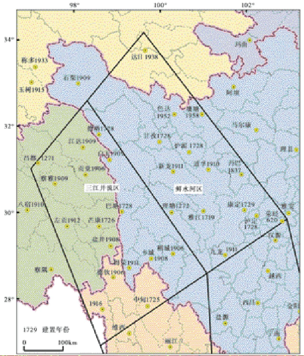
Fig. 2 Establishment time of each county in the border area between Sichuan and Tibet.
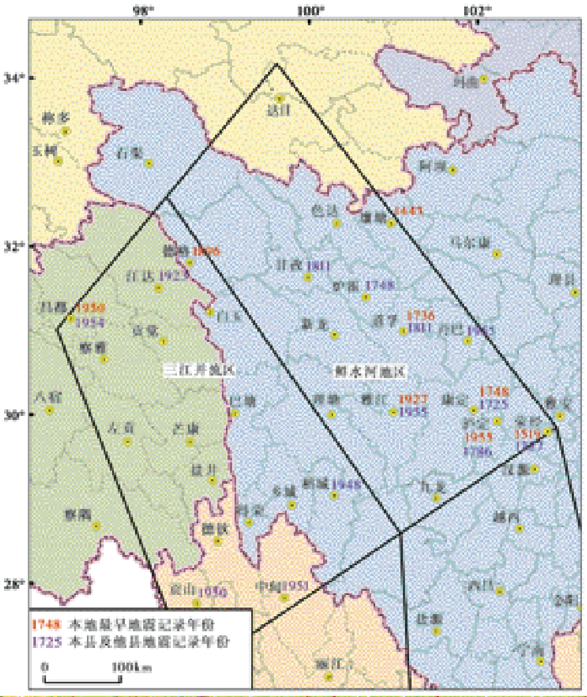
Fig. 3 The earliest earthquake time records locally by the county as well as by the neighboring county.
| 地区 | 序号 | 时间 | 震中 | 震级 | 震中烈度 |
|---|---|---|---|---|---|
| 鲜水河地区 | 1 | 1700 | 四川康定 | 6 | |
| 2 | 1725-08-01 | 四川康定 | 7 | Ⅸ | |
| 3 | 1736 | 四川道孚-乾宁 | 5½ | Ⅶ | |
| 4 | 1741 | 四川道孚-乾宁 | 5 | Ⅵ | |
| 5 | 1742 | 四川道孚-乾宁 | 5 | Ⅵ | |
| 6 | 1747-03 | 四川炉霍 | 6¾ | Ⅷ | |
| 7 | 1748-03-06 | 四川康定 | 5¾ | Ⅶ | |
| 8 | 1748-08-30 | 四川道孚-乾宁 | 6½ | Ⅷ | |
| 9 | 1750 | 四川道孚-乾宁 | 5 | Ⅵ | |
| 10 | 1765 | 四川道孚-乾宁 | 5 | Ⅵ | |
| 11 | 1785 | 四川道孚-乾宁 | 5¾ | Ⅶ | |
| 12 | 1786-06-01 | 四川康定南 | 7¾ | Ⅹ | |
| 13 | 1786-06-02 | 四川康定南 | 6 | ||
| 14 | 1786-06-10 | 四川泸定-得妥 | 7 | ||
| 15 | 1792-09-07 | 四川道孚东南 | 6¾ | Ⅷ | |
| 16 | 1792-11-30 | 四川道孚-乾宁 | 5½ | Ⅶ | |
| 17 | 1793-05-15 | 四川道孚-乾宁 | 6 | Ⅷ | |
| 18 | 1805-09-27 | 四川泸定 | 4¾ | Ⅵ | |
| 19 | 1811-09-27 | 四川炉霍-朱倭 | 6¾ | Ⅸ | |
| 20 | 1816-12-08 | 四川炉霍 | 7½ | Ⅹ | |
| 21 | 1893-08-29 | 四川道孚-乾宁 | 7 | Ⅸ | |
| 22 | 1904-08-30 | 四川道孚 | 7 | Ⅸ | |
| 23 | 1904-09-09 | 四川道孚 | 5½ | Ⅶ | |
| 24 | 1904-09-11 | 四川道孚 | 5½ | Ⅶ | |
| 25 | 1729-03-27 | 四川理塘 | |||
| 26 | 1730 | 四川嘎达 | |||
| 27① | 1746 | 四川甘孜 | |||
| 28① | 1866 | 四川甘孜 | |||
| 29 | 1911-03-30 | 四川荥经、犍为 | |||
| 30 | 1911-09-05 | 四川荥经、犍为 | |||
| 三江并流区 | 1 | 1128 | 西藏芒康 | 5 | ≥Ⅴ |
| 2 | 1722 | 四川巴塘一带 | 6 | ≥Ⅷ | |
| 3 | 1870-04-11 | 四川巴塘 | 7¼ | Ⅹ | |
| 4 | 1908-01-23-1909-12-11 | 巴塘23次地震 |
Table 2 Earthquake catalogue of two regions
| 地区 | 序号 | 时间 | 震中 | 震级 | 震中烈度 |
|---|---|---|---|---|---|
| 鲜水河地区 | 1 | 1700 | 四川康定 | 6 | |
| 2 | 1725-08-01 | 四川康定 | 7 | Ⅸ | |
| 3 | 1736 | 四川道孚-乾宁 | 5½ | Ⅶ | |
| 4 | 1741 | 四川道孚-乾宁 | 5 | Ⅵ | |
| 5 | 1742 | 四川道孚-乾宁 | 5 | Ⅵ | |
| 6 | 1747-03 | 四川炉霍 | 6¾ | Ⅷ | |
| 7 | 1748-03-06 | 四川康定 | 5¾ | Ⅶ | |
| 8 | 1748-08-30 | 四川道孚-乾宁 | 6½ | Ⅷ | |
| 9 | 1750 | 四川道孚-乾宁 | 5 | Ⅵ | |
| 10 | 1765 | 四川道孚-乾宁 | 5 | Ⅵ | |
| 11 | 1785 | 四川道孚-乾宁 | 5¾ | Ⅶ | |
| 12 | 1786-06-01 | 四川康定南 | 7¾ | Ⅹ | |
| 13 | 1786-06-02 | 四川康定南 | 6 | ||
| 14 | 1786-06-10 | 四川泸定-得妥 | 7 | ||
| 15 | 1792-09-07 | 四川道孚东南 | 6¾ | Ⅷ | |
| 16 | 1792-11-30 | 四川道孚-乾宁 | 5½ | Ⅶ | |
| 17 | 1793-05-15 | 四川道孚-乾宁 | 6 | Ⅷ | |
| 18 | 1805-09-27 | 四川泸定 | 4¾ | Ⅵ | |
| 19 | 1811-09-27 | 四川炉霍-朱倭 | 6¾ | Ⅸ | |
| 20 | 1816-12-08 | 四川炉霍 | 7½ | Ⅹ | |
| 21 | 1893-08-29 | 四川道孚-乾宁 | 7 | Ⅸ | |
| 22 | 1904-08-30 | 四川道孚 | 7 | Ⅸ | |
| 23 | 1904-09-09 | 四川道孚 | 5½ | Ⅶ | |
| 24 | 1904-09-11 | 四川道孚 | 5½ | Ⅶ | |
| 25 | 1729-03-27 | 四川理塘 | |||
| 26 | 1730 | 四川嘎达 | |||
| 27① | 1746 | 四川甘孜 | |||
| 28① | 1866 | 四川甘孜 | |||
| 29 | 1911-03-30 | 四川荥经、犍为 | |||
| 30 | 1911-09-05 | 四川荥经、犍为 | |||
| 三江并流区 | 1 | 1128 | 西藏芒康 | 5 | ≥Ⅴ |
| 2 | 1722 | 四川巴塘一带 | 6 | ≥Ⅷ | |
| 3 | 1870-04-11 | 四川巴塘 | 7¼ | Ⅹ | |
| 4 | 1908-01-23-1909-12-11 | 巴塘23次地震 |
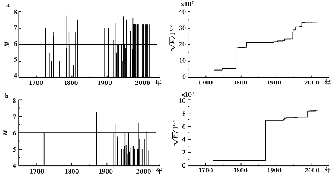
Fig. 4 M-t plot of MS≥4¾ earthquake(left)and cumulative strain energy release plot of earthquakes(right).
| 地区 | 活动时段 | 年平均发生率 |
|---|---|---|
| 鲜水河地区 | 1725-1816 | 0.110 |
| 1893-2022 | 0.155 | |
| 1947-2022 | 0.160 | |
| 三江并流区 | 1722-1870 | 0.014 |
| 1870-2022 | 0.066 | |
| 1920-2022 | 0.088 |
Table 3 Annual average occurrence rates of actual earthquakes in different periods in the two regions(MS≥6)
| 地区 | 活动时段 | 年平均发生率 |
|---|---|---|
| 鲜水河地区 | 1725-1816 | 0.110 |
| 1893-2022 | 0.155 | |
| 1947-2022 | 0.160 | |
| 三江并流区 | 1722-1870 | 0.014 |
| 1870-2022 | 0.066 | |
| 1920-2022 | 0.088 |
Fig. 5 Integrity distribution of earthquake data of Sichuan-Yunnan block(from HUANG Wei-qiong et al., 1994b).
| 时间 | 地点 | 震级 | 烈度 | 史料 |
|---|---|---|---|---|
| 1725-08-01 | 四川康定(打箭炉) | 7 | Ⅸ | 化林协副将张成隆禀报内开:遵奉宪行带兵赴炉驻扎,一路看验,打箭炉之内沈村、猴子坡、烹坝等处,惟猴子坡碉房震倒,其余虽亦地震,不甚伤人(雍正三年九月二十日署川陕总督岳钟琪奏折)。 |
| [雍正]三年夏六月,西炉地震。 | ||||
| 雍正三年六月,西炉地震,番夷碉房崩塌,压死“夷”人无数,土司桑结压死,无人承袭。 | ||||
| 1736年 | 道孚-乾宁(噶达城) | 5½ | Ⅶ | 敕建惠远庙,在噶达城,乾隆元……因地震估修。 |
| 1741年 | 道孚-乾宁(噶达城) | 5 | Ⅵ | 敕建惠远庙,在噶达城……乾隆……六年……因地震估修。 |
| 1742年 | 道孚-乾宁(噶达城) | 5 | Ⅵ | 敕建惠远庙,在噶达城……乾隆……七年……因地震估修。 |
| 1747-03-11-04-09 | 四川炉霍 | 6¾ | ≥Ⅷ | 臣广泗驻营口外,访之夷人,据称地动之事……霍尔章谷(炉霍)各土司地方及金川、小金等地,伤毙藏民颇多。 |
| 1748-03-06 | 四川康定-塔公 | 5¾ | ≥Ⅷ | 据泰宁协禀报:阜和营辖明正土司属之八刹地方,半夜地动3次,摇倒碉房14座,压毙15人,伤34人。 |
| 1748-08-29-30 | 四川道孚-乾宁 | 6½ | Ⅷ | 署川抚班第奏:明正司该管上八义(今道孚县中古)地方百姓六十二家碉房摇倒七十二座,压毙喇嘛、百姓五人。 |
| 章谷、吉地、革什咱、巴旺、边谷各土司地方、俱属同日地震动,甚微。凡碉楼、粮仓、房屋等项,均未摇损。 | ||||
| 1750年 | 四川道孚-乾宁(噶达城) | 5 | Ⅵ | 敕建惠远庙,在噶达城……乾隆……十五年……因地震估修。 |
| 1765年 | 四川道孚-乾宁(噶达城) | 5 | Ⅵ | 敕建惠远庙,在噶达城……乾隆……三十年……因地震估修。 |
| 1785年 | 四川道孚-乾宁(噶达城) | 5¾ | Ⅶ | 乾隆元年及陆、柒年、拾伍年、叁拾年均因地震估修,至伍拾年地震尽圯。 |
| 1786-06-02 | 四川康定南 | ≥6 | 城垣:雍正始建,乾隆二十一年改建,四十一年被水尽圯,重修。五十一年地震,城垣又圯……监狱、仓廒俱重修。 | |
| 1786-06-01 | 四川康定南 | 7¾ | ≥Ⅹ | 原有兵房三百九十八间,丁兵现住三百一十四间,内震塌一百九十二间,又应行估变空闲衙署兵房一百九间,亦并倒塌。 |
| 乾隆丙午五十一年五月初六、七、十一、[十]二等日[遂宁]地动,幸为时甚暂,尚未成灾。 | ||||
| 乾隆五十一年五月初六日,全省地震,邑境地方为时甚暂,不至成灾, | ||||
| 乾隆丙午五十一年五月初六日午时,[犍为]地大震,房屋墙壁势将倾圯,地中有吼声,自北来。 | ||||
| 1792-09-07 | 四川道孚东南 | 6¾ | Ⅷ | 惠远庙:在噶达城,乾隆五十七年七月地震坍塌(原书作五十八年)。 |
| 倒塌楼房平房共一千三百三十八间,照例每大口一名赏银二两,小口一名赏银一两……经臣据详造册,转请督臣衙门咨部在案。 | ||||
| 1792-11-30 | 四川道孚-乾宁(泰宁) | 5½ | Ⅶ | 打箭炉同知徐麟趾具报……至十月十七日,惠远庙地方复经地震。 |
| 1793-05-15 | 四川道孚-乾宁 | 6 | Ⅷ | 窃臣于边坝途次,接据署打箭炉同知徐麟趾禀报,据代防噶达汛千总郑榜禀称:四月初六日子时,泰宁一带,及附近之明正司,革什咱土司地方同时地震。 |
| 1805-09-27 | 四川泸定 | 4¾ | Ⅵ | 泸定桥地方于嘉庆十年八月初五日地震,桥索较前松缓,嗣遇狂风时作,将底链八根先后折断坠河。 |
| 1811-09-27 | 四川炉霍-朱倭 | 6¾ | Ⅸ | 百利、甘孜两处地方地震尚轻,虽房间有倾欹为数无几,亦未压毙人口,无须查造赈恤。惟绰倭土司所管界内被灾较重……平房八十七间,压毙僧俗、大男妇三百七十六丁口。 |
| 1816-12-08 | 四川炉霍 | 7½ | Ⅹ | 打箭炉同知吉恒转据口外角洛汛汛弁禀报:嘉庆二十一年十月二十日丑时,章谷一带地震……逐处确查,勘得共倒塌楼房一百一十八间……楼房每间赏银一两……(嘉庆二十二年二月二十五日四川总督常明奏折)。 |
| 1893-08-29 | 四川道孚-乾宁 | 7 | Ⅸ | 阜和协副将徐联魁、打箭炉同知赵贡会禀:噶达汛地方与七月十八日卯刻地震,压毙兵民,倾倒房屋……计喇嘛及兵民之重伤者一百十四名,每名另给银三两……共拨给银一千三百九十七两,以示赈恤(光绪十九年十月初二日川督刘秉璋奏折)。 |
| 1904-8-30 | 四川道孚 | 7 | Ⅸ | 转据角洛汛把总禀报该汛将军梁等处地方,暨麻书、孔撒两土寨,于七月二十日,三十日,八月初二日三次地震成灾,坍塌居民房屋多间。 |
| 1904-9-9 | ||||
| 1904-9-11 | ||||
| 1729-03-07 | 四川理塘 | 土鸡年(1729年)二月八日到达索朗嘉错(三世达赖)的寺庙,即理塘土钦强巴村附近。当时地发生了连续几天的地震。 | ||
| 1730年 | 四川道孚-嘎达 | 道孚嘎达地方发生多次地震……(活佛)等佛殿后搭帐篷而居。 | ||
| 1746年 | 四川甘孜 | 绒坝岔、生康、甘孜地带发生地震,生康附近的7个自然村被毁坏。 | ||
| 1866年 | 四川甘孜 | 孔萨、麻书土司辖地(甘孜)和绒坝岔一带亦遭受破坏,死亡2000余人。 | ||
| 1911/3/30 | 四川荥经、犍为 | 宣统三年三月,[荥经]地大震。 | ||
| 1911/9/5 | 四川荥经、犍为 | 宣统三年七月十三日,[荥经]地大震。 |
Table 4 Historical records of earthquakes in Xianshui river area(from SUN Cheng-min et al., 2010)
| 时间 | 地点 | 震级 | 烈度 | 史料 |
|---|---|---|---|---|
| 1725-08-01 | 四川康定(打箭炉) | 7 | Ⅸ | 化林协副将张成隆禀报内开:遵奉宪行带兵赴炉驻扎,一路看验,打箭炉之内沈村、猴子坡、烹坝等处,惟猴子坡碉房震倒,其余虽亦地震,不甚伤人(雍正三年九月二十日署川陕总督岳钟琪奏折)。 |
| [雍正]三年夏六月,西炉地震。 | ||||
| 雍正三年六月,西炉地震,番夷碉房崩塌,压死“夷”人无数,土司桑结压死,无人承袭。 | ||||
| 1736年 | 道孚-乾宁(噶达城) | 5½ | Ⅶ | 敕建惠远庙,在噶达城,乾隆元……因地震估修。 |
| 1741年 | 道孚-乾宁(噶达城) | 5 | Ⅵ | 敕建惠远庙,在噶达城……乾隆……六年……因地震估修。 |
| 1742年 | 道孚-乾宁(噶达城) | 5 | Ⅵ | 敕建惠远庙,在噶达城……乾隆……七年……因地震估修。 |
| 1747-03-11-04-09 | 四川炉霍 | 6¾ | ≥Ⅷ | 臣广泗驻营口外,访之夷人,据称地动之事……霍尔章谷(炉霍)各土司地方及金川、小金等地,伤毙藏民颇多。 |
| 1748-03-06 | 四川康定-塔公 | 5¾ | ≥Ⅷ | 据泰宁协禀报:阜和营辖明正土司属之八刹地方,半夜地动3次,摇倒碉房14座,压毙15人,伤34人。 |
| 1748-08-29-30 | 四川道孚-乾宁 | 6½ | Ⅷ | 署川抚班第奏:明正司该管上八义(今道孚县中古)地方百姓六十二家碉房摇倒七十二座,压毙喇嘛、百姓五人。 |
| 章谷、吉地、革什咱、巴旺、边谷各土司地方、俱属同日地震动,甚微。凡碉楼、粮仓、房屋等项,均未摇损。 | ||||
| 1750年 | 四川道孚-乾宁(噶达城) | 5 | Ⅵ | 敕建惠远庙,在噶达城……乾隆……十五年……因地震估修。 |
| 1765年 | 四川道孚-乾宁(噶达城) | 5 | Ⅵ | 敕建惠远庙,在噶达城……乾隆……三十年……因地震估修。 |
| 1785年 | 四川道孚-乾宁(噶达城) | 5¾ | Ⅶ | 乾隆元年及陆、柒年、拾伍年、叁拾年均因地震估修,至伍拾年地震尽圯。 |
| 1786-06-02 | 四川康定南 | ≥6 | 城垣:雍正始建,乾隆二十一年改建,四十一年被水尽圯,重修。五十一年地震,城垣又圯……监狱、仓廒俱重修。 | |
| 1786-06-01 | 四川康定南 | 7¾ | ≥Ⅹ | 原有兵房三百九十八间,丁兵现住三百一十四间,内震塌一百九十二间,又应行估变空闲衙署兵房一百九间,亦并倒塌。 |
| 乾隆丙午五十一年五月初六、七、十一、[十]二等日[遂宁]地动,幸为时甚暂,尚未成灾。 | ||||
| 乾隆五十一年五月初六日,全省地震,邑境地方为时甚暂,不至成灾, | ||||
| 乾隆丙午五十一年五月初六日午时,[犍为]地大震,房屋墙壁势将倾圯,地中有吼声,自北来。 | ||||
| 1792-09-07 | 四川道孚东南 | 6¾ | Ⅷ | 惠远庙:在噶达城,乾隆五十七年七月地震坍塌(原书作五十八年)。 |
| 倒塌楼房平房共一千三百三十八间,照例每大口一名赏银二两,小口一名赏银一两……经臣据详造册,转请督臣衙门咨部在案。 | ||||
| 1792-11-30 | 四川道孚-乾宁(泰宁) | 5½ | Ⅶ | 打箭炉同知徐麟趾具报……至十月十七日,惠远庙地方复经地震。 |
| 1793-05-15 | 四川道孚-乾宁 | 6 | Ⅷ | 窃臣于边坝途次,接据署打箭炉同知徐麟趾禀报,据代防噶达汛千总郑榜禀称:四月初六日子时,泰宁一带,及附近之明正司,革什咱土司地方同时地震。 |
| 1805-09-27 | 四川泸定 | 4¾ | Ⅵ | 泸定桥地方于嘉庆十年八月初五日地震,桥索较前松缓,嗣遇狂风时作,将底链八根先后折断坠河。 |
| 1811-09-27 | 四川炉霍-朱倭 | 6¾ | Ⅸ | 百利、甘孜两处地方地震尚轻,虽房间有倾欹为数无几,亦未压毙人口,无须查造赈恤。惟绰倭土司所管界内被灾较重……平房八十七间,压毙僧俗、大男妇三百七十六丁口。 |
| 1816-12-08 | 四川炉霍 | 7½ | Ⅹ | 打箭炉同知吉恒转据口外角洛汛汛弁禀报:嘉庆二十一年十月二十日丑时,章谷一带地震……逐处确查,勘得共倒塌楼房一百一十八间……楼房每间赏银一两……(嘉庆二十二年二月二十五日四川总督常明奏折)。 |
| 1893-08-29 | 四川道孚-乾宁 | 7 | Ⅸ | 阜和协副将徐联魁、打箭炉同知赵贡会禀:噶达汛地方与七月十八日卯刻地震,压毙兵民,倾倒房屋……计喇嘛及兵民之重伤者一百十四名,每名另给银三两……共拨给银一千三百九十七两,以示赈恤(光绪十九年十月初二日川督刘秉璋奏折)。 |
| 1904-8-30 | 四川道孚 | 7 | Ⅸ | 转据角洛汛把总禀报该汛将军梁等处地方,暨麻书、孔撒两土寨,于七月二十日,三十日,八月初二日三次地震成灾,坍塌居民房屋多间。 |
| 1904-9-9 | ||||
| 1904-9-11 | ||||
| 1729-03-07 | 四川理塘 | 土鸡年(1729年)二月八日到达索朗嘉错(三世达赖)的寺庙,即理塘土钦强巴村附近。当时地发生了连续几天的地震。 | ||
| 1730年 | 四川道孚-嘎达 | 道孚嘎达地方发生多次地震……(活佛)等佛殿后搭帐篷而居。 | ||
| 1746年 | 四川甘孜 | 绒坝岔、生康、甘孜地带发生地震,生康附近的7个自然村被毁坏。 | ||
| 1866年 | 四川甘孜 | 孔萨、麻书土司辖地(甘孜)和绒坝岔一带亦遭受破坏,死亡2000余人。 | ||
| 1911/3/30 | 四川荥经、犍为 | 宣统三年三月,[荥经]地大震。 | ||
| 1911/9/5 | 四川荥经、犍为 | 宣统三年七月十三日,[荥经]地大震。 |
| 时间 | 地点 | 震级 | 震中烈度 | 史料 |
|---|---|---|---|---|
| 1128年前 | 西藏芒康 | >5 | [惹译师]应上、中、下各地百姓邀请,行抵各处,众人纷纷前往迎接。抵戈窝(芒康)当天,猝发大地震,群山震动。 | |
| 1722年 | 四川巴塘 | ≥6 | ≥Ⅷ | 今遵旨复查[康熙]六十一年巴塘等处地震之时,前抚蔡珽赏恤赈济,每压死一人赏银一两;各处办事头人每名赏缎一疋,绫二疋,布四疋,茶二甑,烟八包。俱系前院捐备在案(雍正三年九月二十日川陕总督岳钟琦奏折)。 |
| 1870-04-11 | 四川巴塘一带 | ≥7¼ | Ⅹ | 窃臣于四月初七、十一等日,连据管理巴塘粮务试用通判吴福同、驻防巴塘汛崇化营都司马开昌报称:三月十一日巳刻巴塘一带突然地震山崩,衙署、仓库、碉寨、民房及汉夷军民同时被压,该通判、都司及在台弁均各受伤…… |
| 立功德文约人巴塘大营官罗宗旺登……因同治九年三月十一日陡遭地震,已将关帝城隍庙宇尽行倒塌,复从建修,首事人等现在修理…… | ||||
| 巴塘为川藏接壤,路当孔道,同治九年三月十一日突遭地震,人民沦亡二千余名,大道崩塌四百余里,文报阻塞,人心四散,仰蒙大宪奏委前任军粮府……勘灾请款招夫运粮…… | ||||
| 1870年 | 西藏芒康 | 卑职芒康头人角白顶礼禀告:……加以本地区上下游地段均遭地震灾害,更逢歉收…… | ||
| 1908-1909年 | 四川巴塘27次地震 | 1908-06-09发生了一系列小地震,4km内同感,房屋剧烈作响,有震声,熟睡人惊醒。1909-12-11发生了一系列小地震, 持续1min, 入睡者惊醒, 有震声, 方向自西向东。 |
Table 5 Historical records of earthquakes in the three parallel rivers area(from SUN Cheng-min et al., 2010)
| 时间 | 地点 | 震级 | 震中烈度 | 史料 |
|---|---|---|---|---|
| 1128年前 | 西藏芒康 | >5 | [惹译师]应上、中、下各地百姓邀请,行抵各处,众人纷纷前往迎接。抵戈窝(芒康)当天,猝发大地震,群山震动。 | |
| 1722年 | 四川巴塘 | ≥6 | ≥Ⅷ | 今遵旨复查[康熙]六十一年巴塘等处地震之时,前抚蔡珽赏恤赈济,每压死一人赏银一两;各处办事头人每名赏缎一疋,绫二疋,布四疋,茶二甑,烟八包。俱系前院捐备在案(雍正三年九月二十日川陕总督岳钟琦奏折)。 |
| 1870-04-11 | 四川巴塘一带 | ≥7¼ | Ⅹ | 窃臣于四月初七、十一等日,连据管理巴塘粮务试用通判吴福同、驻防巴塘汛崇化营都司马开昌报称:三月十一日巳刻巴塘一带突然地震山崩,衙署、仓库、碉寨、民房及汉夷军民同时被压,该通判、都司及在台弁均各受伤…… |
| 立功德文约人巴塘大营官罗宗旺登……因同治九年三月十一日陡遭地震,已将关帝城隍庙宇尽行倒塌,复从建修,首事人等现在修理…… | ||||
| 巴塘为川藏接壤,路当孔道,同治九年三月十一日突遭地震,人民沦亡二千余名,大道崩塌四百余里,文报阻塞,人心四散,仰蒙大宪奏委前任军粮府……勘灾请款招夫运粮…… | ||||
| 1870年 | 西藏芒康 | 卑职芒康头人角白顶礼禀告:……加以本地区上下游地段均遭地震灾害,更逢歉收…… | ||
| 1908-1909年 | 四川巴塘27次地震 | 1908-06-09发生了一系列小地震,4km内同感,房屋剧烈作响,有震声,熟睡人惊醒。1909-12-11发生了一系列小地震, 持续1min, 入睡者惊醒, 有震声, 方向自西向东。 |
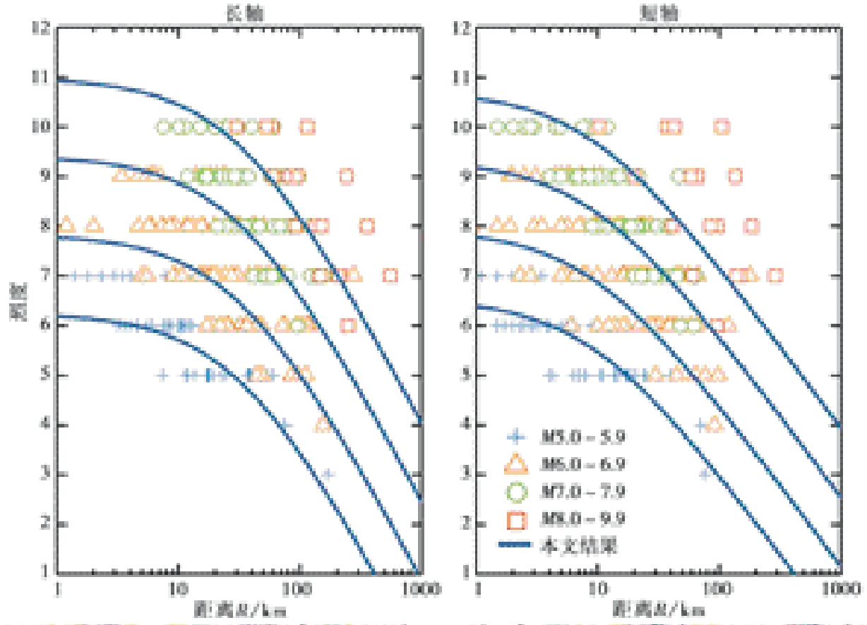
Fig. 6 Scaling of the attenuation relationship of intensity with magnitude and distance in Sichuan-Yunnan block, together with plots of intensity record data.
| 方向 | A | B | C | R0 | |
|---|---|---|---|---|---|
| 长轴 | 5.306 | 1.578 | -4.610 | 32 | 0.568 |
| 短轴 | 2.736 | 1.393 | -3.309 | 9 | 0.471 |
Table 6 Seismic intensity attenuation coefficients
| 方向 | A | B | C | R0 | |
|---|---|---|---|---|---|
| 长轴 | 5.306 | 1.578 | -4.610 | 32 | 0.568 |
| 短轴 | 2.736 | 1.393 | -3.309 | 9 | 0.471 |
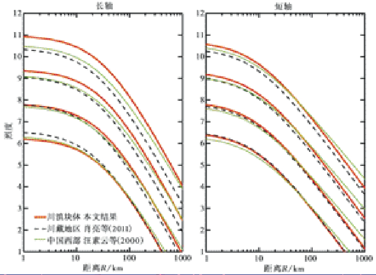
Fig. 7 Comparison of attenuation curves from different previous studies.
| 发震日期 | 震级 | 震中位置 | 最远记载点(震中距) | 影响烈度计算值 | M' |
|---|---|---|---|---|---|
| 1725-08-01 | 7 | 四川康定 | 巴塘(270km) | 5.3 | 6.2 |
| 1786-06-01 | 7¾ | 四川康定南 | 湖南黔阳(845.7km) | 4.0 | 5.4 |
| 1811-09-27 | 6¾ | 四川炉霍-朱倭 | 理塘(191km) | 4.8 | 6.1 |
| 1870-04-11 | 7¼ | 四川巴塘 | 昌都亦震(224km) | 5.3 | 6.4 |
Table 7 The farthest recorded distance of earthquake(MS≥6¾) and the calculated value of corresponding intensity
| 发震日期 | 震级 | 震中位置 | 最远记载点(震中距) | 影响烈度计算值 | M' |
|---|---|---|---|---|---|
| 1725-08-01 | 7 | 四川康定 | 巴塘(270km) | 5.3 | 6.2 |
| 1786-06-01 | 7¾ | 四川康定南 | 湖南黔阳(845.7km) | 4.0 | 5.4 |
| 1811-09-27 | 6¾ | 四川炉霍-朱倭 | 理塘(191km) | 4.8 | 6.1 |
| 1870-04-11 | 7¼ | 四川巴塘 | 昌都亦震(224km) | 5.3 | 6.4 |
Fig. 8 Isoseismal map of intensity attenuation relationship of magnitude 6 in this paper.

Fig. 9 Isoseismal map of intensity attenuation relationship of magnitude 7 in this paper.
| [1] |
陈达生, 刘汉兴. 1989. 地震烈度椭圆衰减关系[J]. 华北地震科学, 7(3): 31-42.
|
|
|
|
| [2] |
甘孜县地方志编纂委员会. 1999. 甘孜县志[M]. 成都: 四川科学技术出版社:71.
|
|
Ganzi County Annals Compilation Committee. 1999. Ganzi County Annals[M]. Sichuan Publishing House of Science & Technology, Chengdu: 71.
|
|
| [3] |
胡聿贤. 2006. 地震工程学[M]. 北京: 地震出版社.
|
|
|
|
| [4] |
黄玮琼, 李文香, 曹学锋. 1994a. 中国大陆地震资料完整性研究之一: 以华北地区为例[J]. 地震学报, 16(3): 273-280.
|
|
|
|
| [5] |
黄玮琼, 李文香, 曹学锋. 1994b. 中国大陆地震资料完整性研究之二: 分区地震资料基本完整的起始年分布图象[J]. 地震学报, 16(4): 423-432.
|
|
|
|
| [6] |
雷建成, 高孟潭, 俞言祥. 2006. 西南地区近代地震的震中烈度与有感半径的统计研究[J]. 震灾防御技术, 1(2): 137-145.
|
|
|
|
| [7] |
李凤珍. 2001. 清朝对西藏与四川、 青海、 云南行政分界的勘定[J]. 西藏研究, (1): 66-73.
|
|
|
|
| [8] |
李研军. 2013. 清代前期川藏大道塘汛设置研究[D]. 咸阳: 西藏民族学院.
|
|
|
|
| [9] |
芒康县地方志编纂委员会. 2008. 芒康县志[M]. 成都: 四川出版集团巴蜀书社:12.
|
|
Mangkang County Annals Compilation Committee. 2008. Mangkang County Annals[M]. Sichuan Publishing Group Bashu Publishing House, Chengdu: 12.
|
|
| [10] |
秦和平. 2017. 述论清代甘孜藏区的设治特点及演变状况[J]. 西南民族大学学报(人文社会科学版), 38(2): 225-233.
|
|
|
|
| [11] |
四川省巴塘县志编纂委员会. 1993. 巴塘县志[M]. 成都: 四川民族出版社:54.
|
|
Sichuan Batang County Annals Compilation Committee. 1993. Batang County Annals[M]. Sichuan Ethnic Publishing House, Chengdu: 54 (in Chinese).
|
|
| [12] |
苏有锦, 李永莉, 李忠华, 等. 2003. 川滇地区区域地震目录完整性最小震级分析[J]. 地震研究, 26(S1): 10-16.
|
|
|
|
| [13] |
孙成民, 王力, 解伟, 等. 2010. 四川地震全记录[M]. 成都: 四川人民出版社.
|
|
|
|
| [14] |
孙继浩, 帅向华. 2011. 川滇及其邻区中强地震烈度衰减关系适用性研究[J]. 地震工程与工程振动, 31(1): 11-18.
|
|
|
|
| [15] |
王海涛, 李莹甄, 屠泓为. 2006. 新疆历史地震目录完整性分析[J]. 内陆地震, 20(1): 10-17.
|
|
|
|
| [16] |
汪素云, 俞言祥, 高阿甲, 等. 2000. 中国分区地震动衰减关系的确定[J]. 中国地震, 16(2): 5-12.
|
|
|
|
| [17] |
肖亮, 俞言祥. 2011. 中国西部地区地震烈度衰减关系[J]. 震灾防御技术, 6(4): 358-371.
|
|
|
|
| [18] |
谢卓娟, 李山有, 吕悦军, 等. 2020. 中国海域及邻区统一地震目录及其完整性分析[J]. 地震地质, 42(4): 993-1019.
|
|
|
|
| [19] |
徐伟进, 高孟潭. 2014. 中国大陆及周缘地震目录完整性统计分析[J]. 地球物理学报, 57(9): 2802-2812.
|
|
|
|
| [20] |
杨福泉. 2018. 茶马古道: 一条写满历史的高原古文明之路[J]. 新西部,(13): 84-85.
|
|
|
|
| [21] |
杨江林. 2019. 清代川藏南路沿线粮台的设置与管理[J]. 西北民族论丛, 20(2): 193-209, 348.
|
|
|
|
| [22] |
张培震, 邓起东, 张国民, 等. 2003. 中国大陆的强震活动与活动地块[J]. 中国科学(D辑), 33(S1): 12-20.
|
|
|
|
| [23] |
张培震, 邓起东, 张竹琪, 等. 2013. 中国大陆的活动断裂、 地震灾害及其动力过程[J]. 中国科学(D辑), 43(10): 1607-1620.
|
|
|
|
| [24] |
张钦. 2020. 清代川藏交通研究[D]. 西安: 陕西师范大学.
|
|
|
|
| [25] |
赵心愚. 2019. 清康熙雍正时期川藏道汛塘与粮台的设置及其特点[J]. 民族研究, (2): 116-124, 142.
|
|
|
|
| [26] |
中国科学院地震工作委员会历史组. 1956. 中国地震资料年表(下册)[M]. 北京: 科学出版社.
|
|
History Group of Seismological Work Committee of Chinese Academy of Sciences. 1956. Chronology of Seismic Data in China(Volume Ⅱ)[M]. Science Press, Beijing (in Chinese).
|
|
| [27] |
周中红, 何少林, 陈文凯. 2010. 甘肃省地震烈度衰减关系研究[J]. 西北地震学报, 32(1): 72-75.
|
|
|
|
| [28] |
邹立波. 2009. 清代前期康区塘汛的设置及其作用与影响[J]. 西藏研究, (3): 28-35.
|
|
|
|
| [29] |
DOI URL |
| [1] | DU Jun-hui, YAN Li-li, QU Chun-yan, LIU Zhi, SHAN Xin-jian. THE SEISMIC DATA MODEL OPTIMIZATION METHOD AND PRELIMINARY APPLICATION [J]. SEISMOLOGY AND GEOLOGY, 2011, 33(3): 706-718. |
| [2] | WANG Xiao-long, NI Si-dao, LIU Yuan-yuan, YU Guo-zheng, LI Ke-chang. STUDY OF CRUSTAL THICKNESS VARIATION IN CHONGQING SECTION OF THREE GORGES RESERVOIR AREA FROM TELESEISMIC RECEIVER FUNCTION METHOD [J]. SEISMOLOGY AND GEOLOGY, 2010, 32(4): 543-551. |
| [3] | ZHOU Jun-jie, LI Shi-xiang, JIA Yun-qiao, LIU Hai-xin. THE RESEARCH ON THE ACQUISITION TECHNOLOGY OF 3-D SEISMIC EXPLORATION IN COAL FIELD IN COMPLICATED MOUNTAINOUS AREA [J]. SEISMOLOGY AND EGOLOGY, 2007, 29(1): 105-113. |
| [4] | SONG Wei-qi, ZHAO Wan-jin, WU Hua, FENG Lei. INVERSION OF SEISMIC DATA BY USING MULTI-RESOLUTION WAVELET NETWORKS [J]. SEISMOLOGY AND GEOLOGY, 2005, 27(1): 98-104. |
| Viewed | ||||||
|
Full text |
|
|||||
|
Abstract |
|
|||||
