SEISMOLOGY AND GEOLOGY ›› 2023, Vol. 45 ›› Issue (5): 1074-1091.DOI: 10.3969/j.issn.0253-4967.2023.05.003
Previous Articles Next Articles
CHEN Yi( ), ZHAO Bin*(), XIONG Wei, WANG Wei, YU Peng-fei, YU Jian-sheng, WANG Dong-zhen, CHEN Wei, QIAO Xue-jun
Received:2022-11-29
Revised:2023-02-04
Online:2023-10-20
Published:2023-11-23
陈毅(), 赵斌*(), 熊维, 王伟, 余鹏飞, 余建胜, 王东振, 陈威, 乔学军
通讯作者:
赵斌, 男, 1981年生, 研究员, 硕士生导师, 现主要从事采用震后形变资料探测断层面摩擦特性和区域岩石圈流变结构研究, E-mail: 作者简介:陈毅, 男, 1997年生, 现为中国地震局地震研究所大地测量学与测量工程专业在读研究生, 研究方向为InSAR和GPS地壳形变观测, E-mail: chenyi@cgps.ac.cn。
基金资助:CHEN Yi, ZHAO Bin, XIONG Wei, WANG Wei, YU Peng-fei, YU Jian-sheng, WANG Dong-zhen, CHEN Wei, QIAO Xue-jun. INTERSEISMIC SLIP RATES AND SHALLOW CREEP ALONG THE NORTHWESTERN SEGMENT OF THE XIANSHUIHE FAULT FROM INSAR DATA[J]. SEISMOLOGY AND GEOLOGY, 2023, 45(5): 1074-1091.
陈毅, 赵斌, 熊维, 王伟, 余鹏飞, 余建胜, 王东振, 陈威, 乔学军. InSAR数据约束的鲜水河断裂带北西段震间滑动速率及浅部蠕滑特征[J]. 地震地质, 2023, 45(5): 1074-1091.
Add to citation manager EndNote|Ris|BibTeX
URL: https://www.dzdz.ac.cn/EN/10.3969/j.issn.0253-4967.2023.05.003
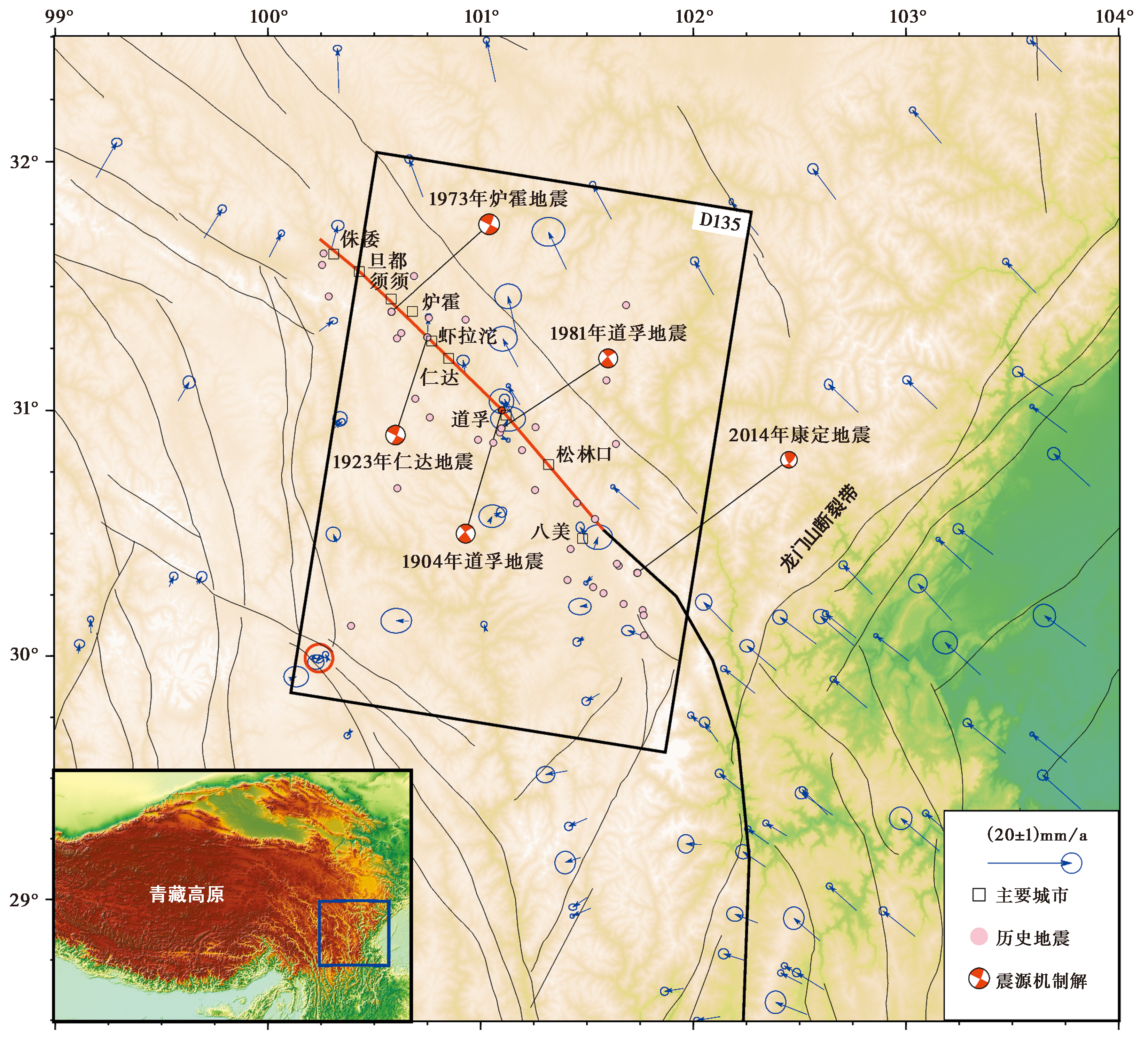
Fig. 1 Tectonic setting of the Xianshuihe fault zone.
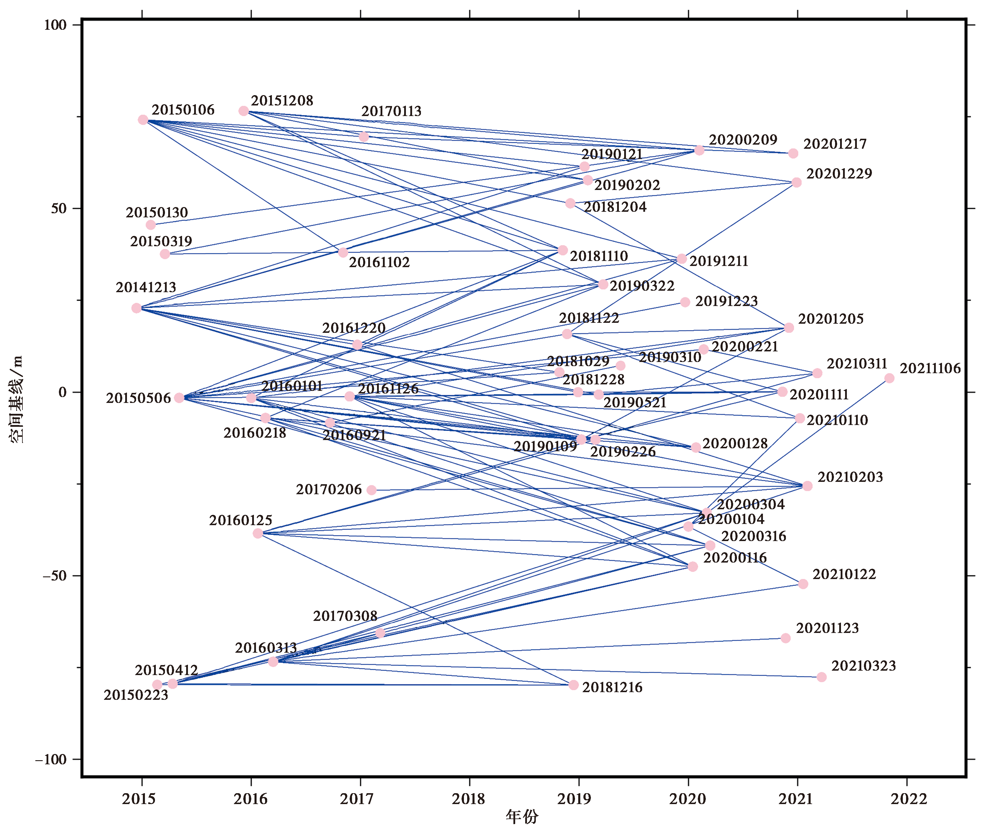
Fig. 2 Spatio-temporal baseline plots of descending track T135.
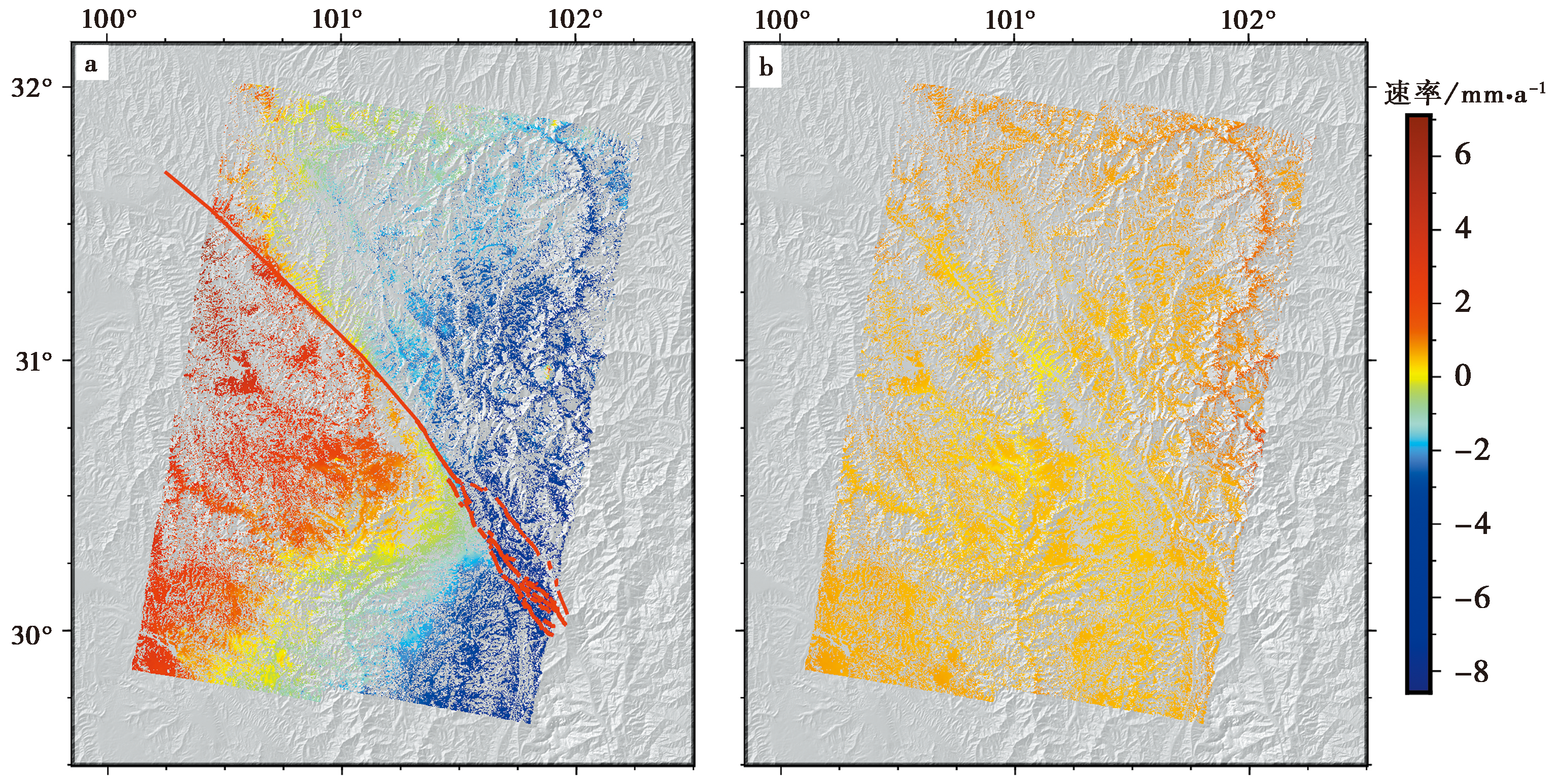
Fig. 3 Line-of-sight velocities across the Xianshuihe fault zone(a), standard deviation(b).
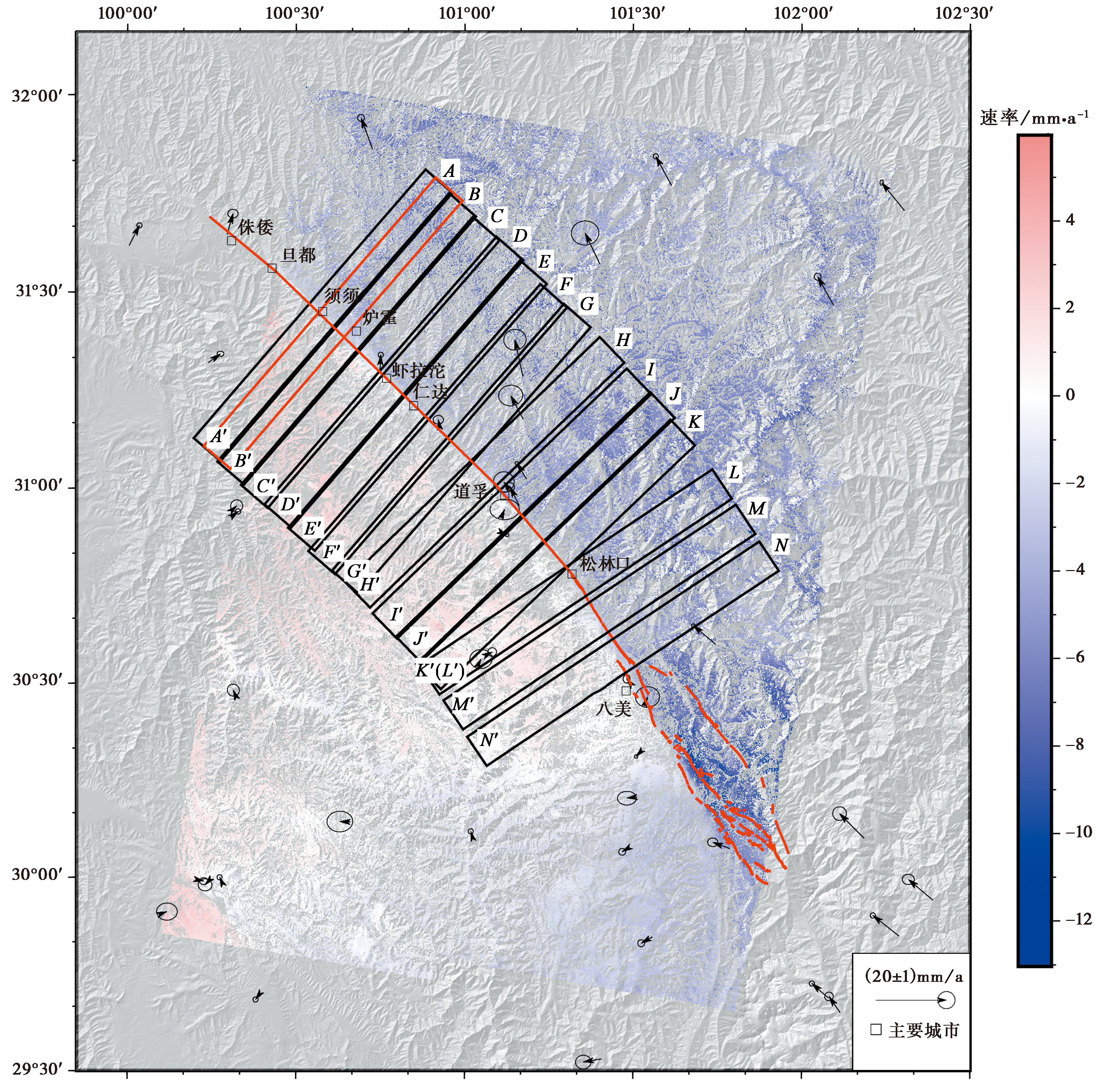
Fig. 4 Fault-parallel velocities along the Xianshuihe fault zone.
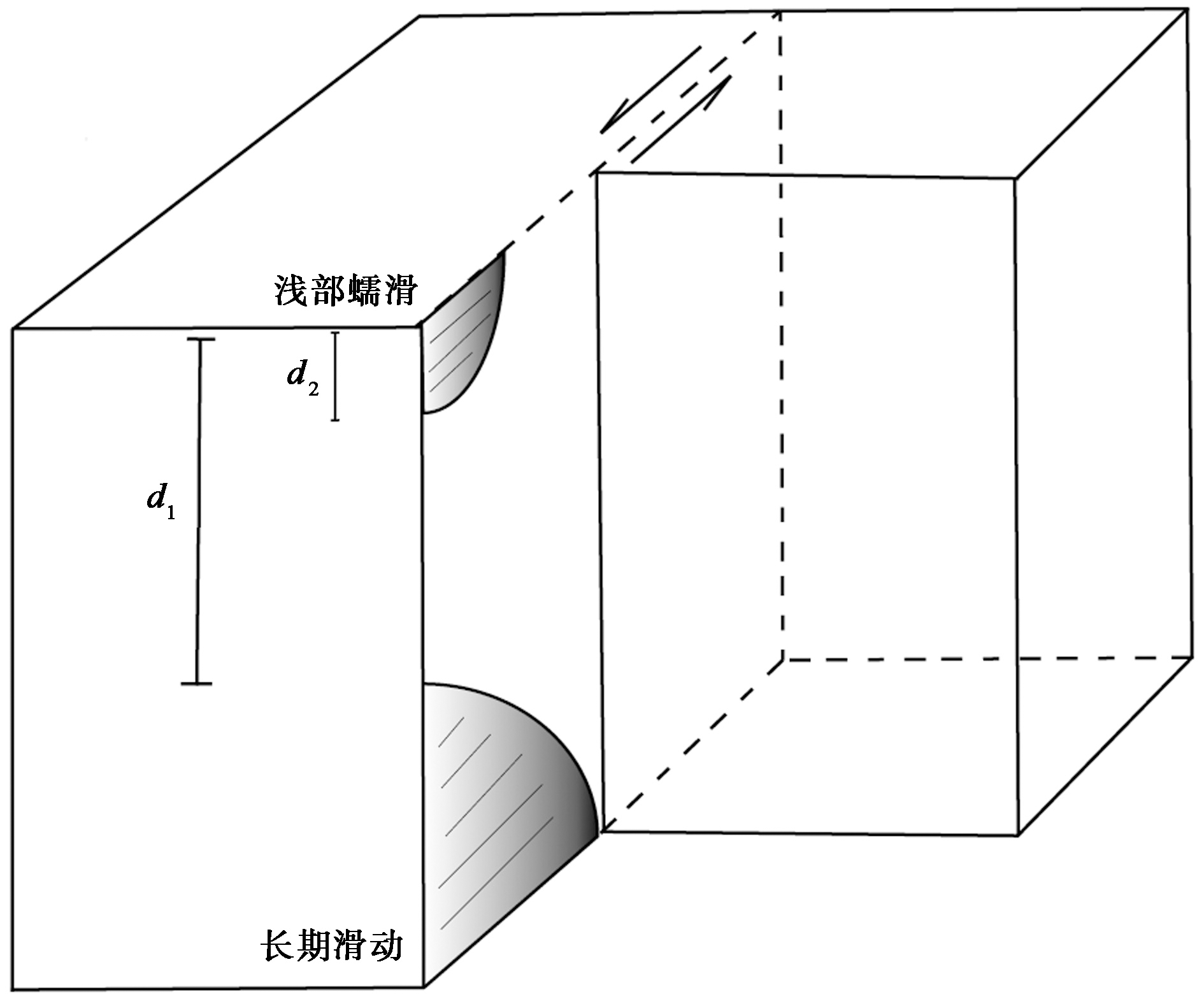
Fig. 5 A schematic of the screw dislocation model.

Fig. 6 Comparied observed fault-parallel velocities to modeled velocities.
| 地震复发周期/a | 黏滞系数/Pa·s | 滑动速率/mm·a-1 | 闭锁深度/km | WRMS/mm·a-1 |
|---|---|---|---|---|
| 150 | 5.0×10¹⁸ | 8.99±0.4 | 4.73±0.8 | 0.7886 |
| 150 | 1.0×10¹⁹ | 9.13±0.4 | 6.96±1.0 | 0.7883 |
| 150 | 5.0×10¹⁹ | 9.85±0.4 | 8.52±1.2 | 0.7881 |
| 200 | 5.0×10¹⁸ | 7.91±0.3 | 4.67±0.7 | 0.7889 |
| 200 | 1.0×10¹⁹ | 8.22±0.3 | 7.35±1.0 | 0.7920 |
| 200 | 5.0×10¹⁹ | 9.56±0.4 | 9.07±1.2 | 0.7906 |
| 400 | 5.0×10¹⁸ | 5.21±0.2 | 4.43±0.5 | 0.7984 |
| 400 | 1.0×10¹⁹ | 5.64±0.2 | 8.03±1.0 | 0.7997 |
| 400 | 5.0×10¹⁹ | 8.26±0.4 | 11.17±1.1 | 0.8022 |
Table 1 Slip rate of Luhuo segment, Xianshuihe Fault
| 地震复发周期/a | 黏滞系数/Pa·s | 滑动速率/mm·a-1 | 闭锁深度/km | WRMS/mm·a-1 |
|---|---|---|---|---|
| 150 | 5.0×10¹⁸ | 8.99±0.4 | 4.73±0.8 | 0.7886 |
| 150 | 1.0×10¹⁹ | 9.13±0.4 | 6.96±1.0 | 0.7883 |
| 150 | 5.0×10¹⁹ | 9.85±0.4 | 8.52±1.2 | 0.7881 |
| 200 | 5.0×10¹⁸ | 7.91±0.3 | 4.67±0.7 | 0.7889 |
| 200 | 1.0×10¹⁹ | 8.22±0.3 | 7.35±1.0 | 0.7920 |
| 200 | 5.0×10¹⁹ | 9.56±0.4 | 9.07±1.2 | 0.7906 |
| 400 | 5.0×10¹⁸ | 5.21±0.2 | 4.43±0.5 | 0.7984 |
| 400 | 1.0×10¹⁹ | 5.64±0.2 | 8.03±1.0 | 0.7997 |
| 400 | 5.0×10¹⁹ | 8.26±0.4 | 11.17±1.1 | 0.8022 |
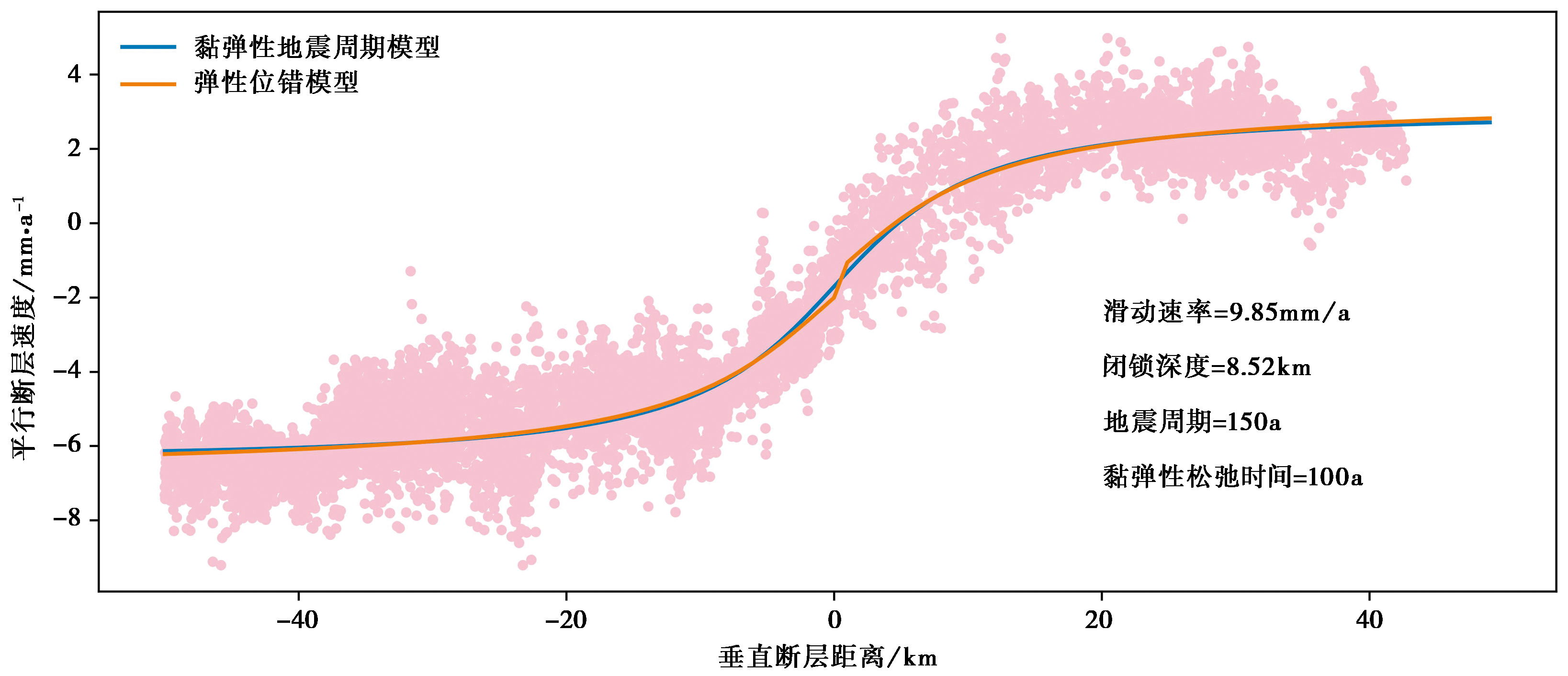
Fig. 7 Best-fit profile of Luhuo.
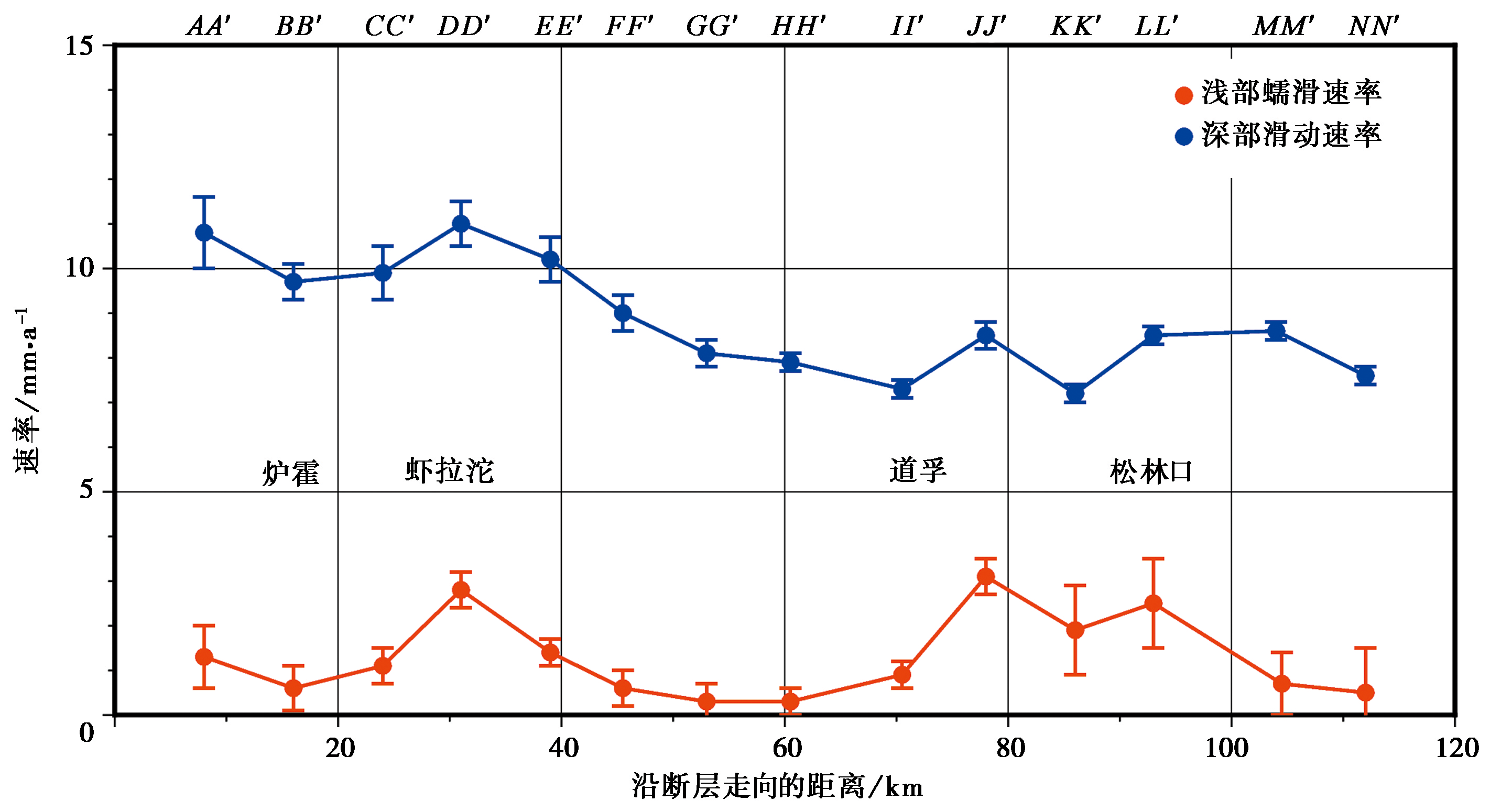
Fig. 8 Deep and shallow creep rates along the Xianshuihe Fault.
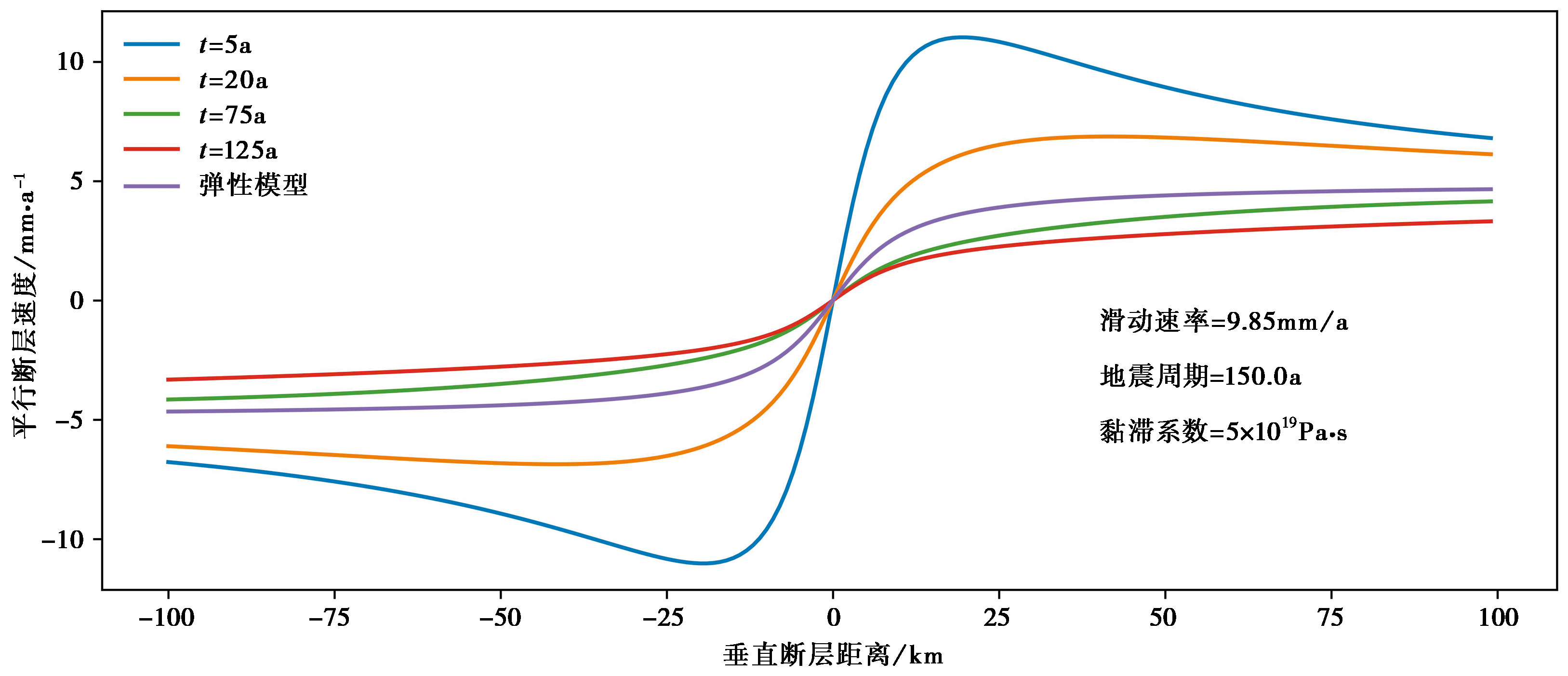
Fig. 9 Calculated velocity profiles across the Luhuo segment of the Xianshuihe Fault at different times after the last earthquake.
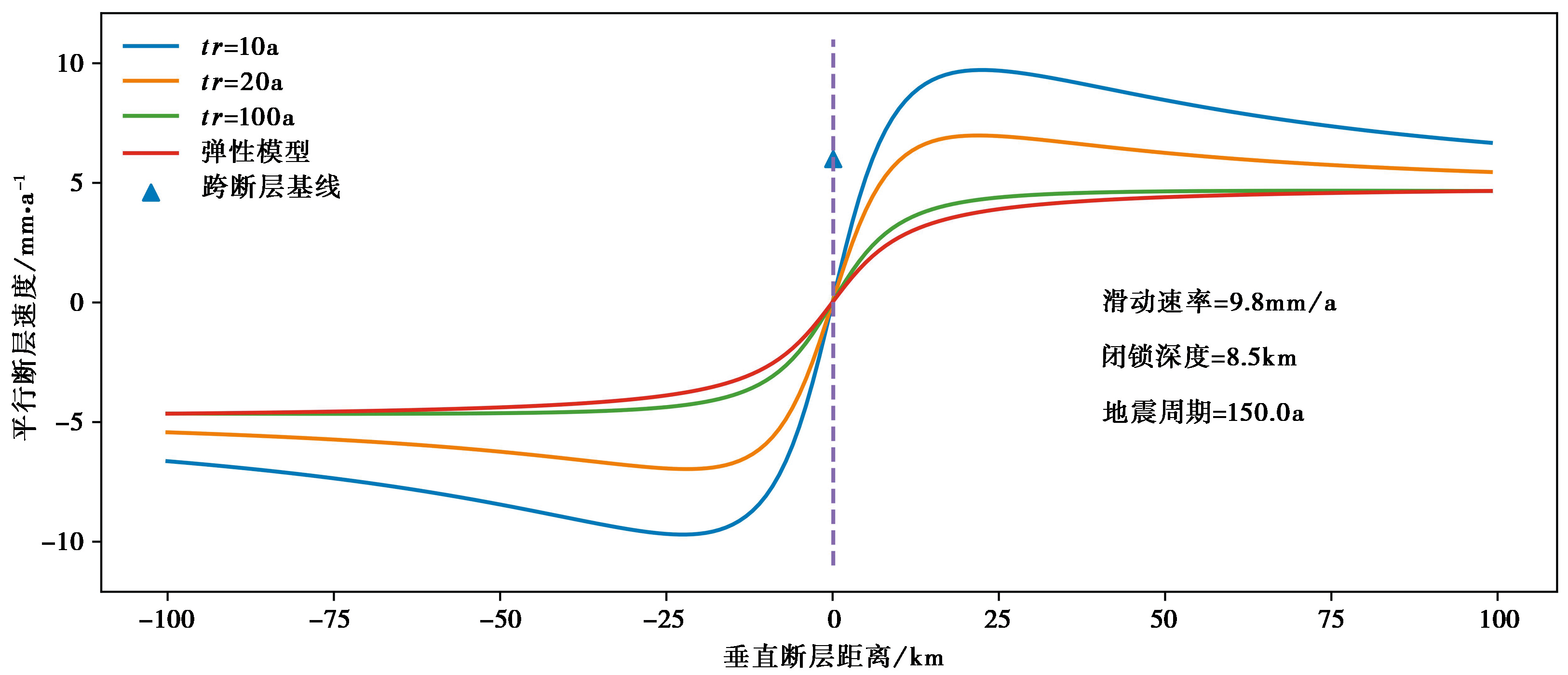
Fig. 10 Comparison of observed surface velocities to calculated velocities across Luhuo segment of Xianshuihe Fault at 8 years after the Luhuo earthquake with different Maxwell relaxation times.
| [1] |
杜方, 闻学泽, 张培震. 2010. 鲜水河断裂带炉霍段的震后滑动与形变[J]. 地球物理学报, 53(10): 2355—2366.
|
|
|
|
| [2] |
李建中. 1986. 鲜水河断裂带现今构造形变[J]. 地壳形变与地震, (3): 181—192.
|
|
|
|
| [3] |
刘本培. 1985. 鲜水河断裂带的地震形变与断层蠕动[J]. 四川地震, (2): 10—15, 40.
|
|
|
|
| [4] |
孙凯, 孟国杰, 洪顺英, 等. 2021. 联合InSAR和GPS研究鲜水河断裂带炉霍—道孚段震间运动特征[J]. 地球物理学报, 64(7): 2278—2296.
|
|
|
|
| [5] |
闻学泽. 1990. 鲜水河断裂带未来三十年内地震复发的条件概率[J]. 中国地震, 6(4): 8—16.
|
|
|
|
| [6] |
杨见兵. 2020. 鲜水河断裂西北段地震周期过程滑动分布的时空演化及机理研究[D]. 武汉: 中国地震局地震研究所:26—28.
|
|
|
|
| [7] |
张晁军, 曹建玲, 石耀霖. 2008. 从震后形变探讨青藏高原下地壳黏滞系数[J]. 中国科学(D辑), 38(10): 1250—1257.
|
|
|
|
| [8] |
DOI URL |
| [9] |
DOI URL |
| [10] |
DOI URL |
| [11] |
DOI URL |
| [12] |
DOI URL |
| [13] |
DOI URL |
| [14] |
DOI URL |
| [15] |
Dixon T,
|
| [16] |
DOI |
| [17] |
DOI URL |
| [18] |
DOI URL |
| [19] |
DOI URL |
| [20] |
DOI URL |
| [21] |
DOI URL |
| [22] |
|
| [23] |
DOI URL |
| [24] |
|
| [25] |
DOI URL |
| [26] |
DOI URL |
| [27] |
DOI URL |
| [28] |
DOI URL |
| [29] |
DOI URL |
| [30] |
|
| [31] |
DOI URL |
| [32] |
|
| [33] |
DOI URL |
| [34] |
|
| [35] |
|
| [36] |
|
| [37] |
|
| [38] |
DOI URL |
| [39] |
DOI |
| [40] |
DOI URL |
| [41] |
DOI URL |
| [42] |
DOI URL |
| Viewed | ||||||
|
Full text |
|
|||||
|
Abstract |
|
|||||
