
SEISMOLOGY AND GEOLOGY ›› 2023, Vol. 45 ›› Issue (6): 1265-1285.DOI: 10.3969/j.issn.0253-4967.2023.06.002
• Research paper • Previous Articles Next Articles
THE LATE QUATERNARY ACTIVITY CHARACTERISTICS AND SLIP RATE OF BATANG FAULT IN SE TIBETAN PLATEAU
HUANG Wei-liang1)( ), ZHANG Jia-le1), XIANG Wen1,2), YANG Qian-hao1,3)
- 1) College of Geological Engineering and Surveying of Chang'an University, Key Laboratory of Western China Mineral Resources and Geological Engineering, Xi'an 710054, China
2) Anqing Copper Mine, Tongling Nonferrous Metals Group Holdings Co. Ltd., Anqing 246000, China
3) Nuclear Industry Jinhua Exploration Design Institute Co., Ltd., Jinhua 321000, China
-
Received:2023-03-21Revised:2023-05-31Online:2023-12-20Published:2024-01-16
晚第四纪以来巴塘断裂的活动特征及滑动速率
黄伟亮1)(), 张家乐1), 项闻1,2), 杨虔灏1,3)
- 1) 长安大学, 地质工程与测绘学院, 西部矿产资源与地质工程教育部重点实验室, 西安 710054
2) 铜陵有色金属集团股份有限公司安庆铜矿, 安庆 246000
3) 核工业金华勘测设计院有限公司, 金华 321000
-
作者简介:黄伟亮, 男, 1987年生, 2015年于中国地震局地质研究所获构造地质学博士学位, 副教授, 主要从事活动构造与古地震、 区域稳定工程地质与地质灾害等研究, E-mail: huangweiliang@chd.edu.cn。
-
基金资助:国家自然科学基金(42041006); 国家自然科学基金(42277152); 中央高校基本科研业务专项(300102262910)
Cite this article
HUANG Wei-liang, ZHANG Jia-le, XIANG Wen, YANG Qian-hao. THE LATE QUATERNARY ACTIVITY CHARACTERISTICS AND SLIP RATE OF BATANG FAULT IN SE TIBETAN PLATEAU[J]. SEISMOLOGY AND GEOLOGY, 2023, 45(6): 1265-1285.
黄伟亮, 张家乐, 项闻, 杨虔灏. 晚第四纪以来巴塘断裂的活动特征及滑动速率[J]. 地震地质, 2023, 45(6): 1265-1285.
share this article
Add to citation manager EndNote|Ris|BibTeX
URL: https://www.dzdz.ac.cn/EN/10.3969/j.issn.0253-4967.2023.06.002

Fig. 1 Tectonic geomorphology and fault distribution around the Southeastern margin of the Tibetan plateau.
| 样品编号 | 位置 | 高程 /m | 样品 深度 /cm | 石英a 质量a /g | 9Be载体 质量 /mg | 10Be/9Beb | 10Be浓度b /104atoms·g-1 | 1σ总误差c /% | 年龄 /ka | ||
|---|---|---|---|---|---|---|---|---|---|---|---|
| 北纬 /(°) | 东经 /(°) | ||||||||||
| BT10BE-1 | 30.09 | 99.15 | 2762 | 2 | 29.09 | 0.24 | 1.63×10⁻¹³ | 9.68 | 8.08 | 4.1±0.3 | |
| BT10BE-2 | 30.09 | 99.16 | 2775 | 2 | 31.20 | 0.25 | 5.32×10⁻¹³ | 10.71 | 4.74 | 12.5±0.5 | |
| XJTBE-1 | 30.01 | 99.12 | 2569 | 2 | 29.52 | 0.24 | 0.29×10⁻¹³ | 1.65 | 17.1 | 0.8±0.1 | |
| T2BE-4 | 30.01 | 99.16 | 2590 | 2 | 29.98 | 0.24 | 8.24×10⁻¹³ | 45.4 | 15.1 | 15.2+3.2/-5.4c 16.4+3.9/-5.6d | |
| T2BE-3 | 30.01 | 99.16 | 2590 | 100 | 23.53 | 0.25 | 0.82×10⁻¹³ | 6.05 | 10.1 | ||
| T2BE-2 | 30.01 | 99.16 | 2590 | 130 | 30.42 | 0.24 | 0.99×10⁻¹³ | 5.27 | 10.1 | ||
| T2BE-1 | 30.01 | 99.16 | 2590 | 200 | 29.09 | 0.25 | 0.34×10⁻¹³ | 1.93 | 17.4 | ||
Table1 Analytical results of terrestrial cosmogenic nuclide 10Be geochronology
| 样品编号 | 位置 | 高程 /m | 样品 深度 /cm | 石英a 质量a /g | 9Be载体 质量 /mg | 10Be/9Beb | 10Be浓度b /104atoms·g-1 | 1σ总误差c /% | 年龄 /ka | ||
|---|---|---|---|---|---|---|---|---|---|---|---|
| 北纬 /(°) | 东经 /(°) | ||||||||||
| BT10BE-1 | 30.09 | 99.15 | 2762 | 2 | 29.09 | 0.24 | 1.63×10⁻¹³ | 9.68 | 8.08 | 4.1±0.3 | |
| BT10BE-2 | 30.09 | 99.16 | 2775 | 2 | 31.20 | 0.25 | 5.32×10⁻¹³ | 10.71 | 4.74 | 12.5±0.5 | |
| XJTBE-1 | 30.01 | 99.12 | 2569 | 2 | 29.52 | 0.24 | 0.29×10⁻¹³ | 1.65 | 17.1 | 0.8±0.1 | |
| T2BE-4 | 30.01 | 99.16 | 2590 | 2 | 29.98 | 0.24 | 8.24×10⁻¹³ | 45.4 | 15.1 | 15.2+3.2/-5.4c 16.4+3.9/-5.6d | |
| T2BE-3 | 30.01 | 99.16 | 2590 | 100 | 23.53 | 0.25 | 0.82×10⁻¹³ | 6.05 | 10.1 | ||
| T2BE-2 | 30.01 | 99.16 | 2590 | 130 | 30.42 | 0.24 | 0.99×10⁻¹³ | 5.27 | 10.1 | ||
| T2BE-1 | 30.01 | 99.16 | 2590 | 200 | 29.09 | 0.25 | 0.34×10⁻¹³ | 1.93 | 17.4 | ||
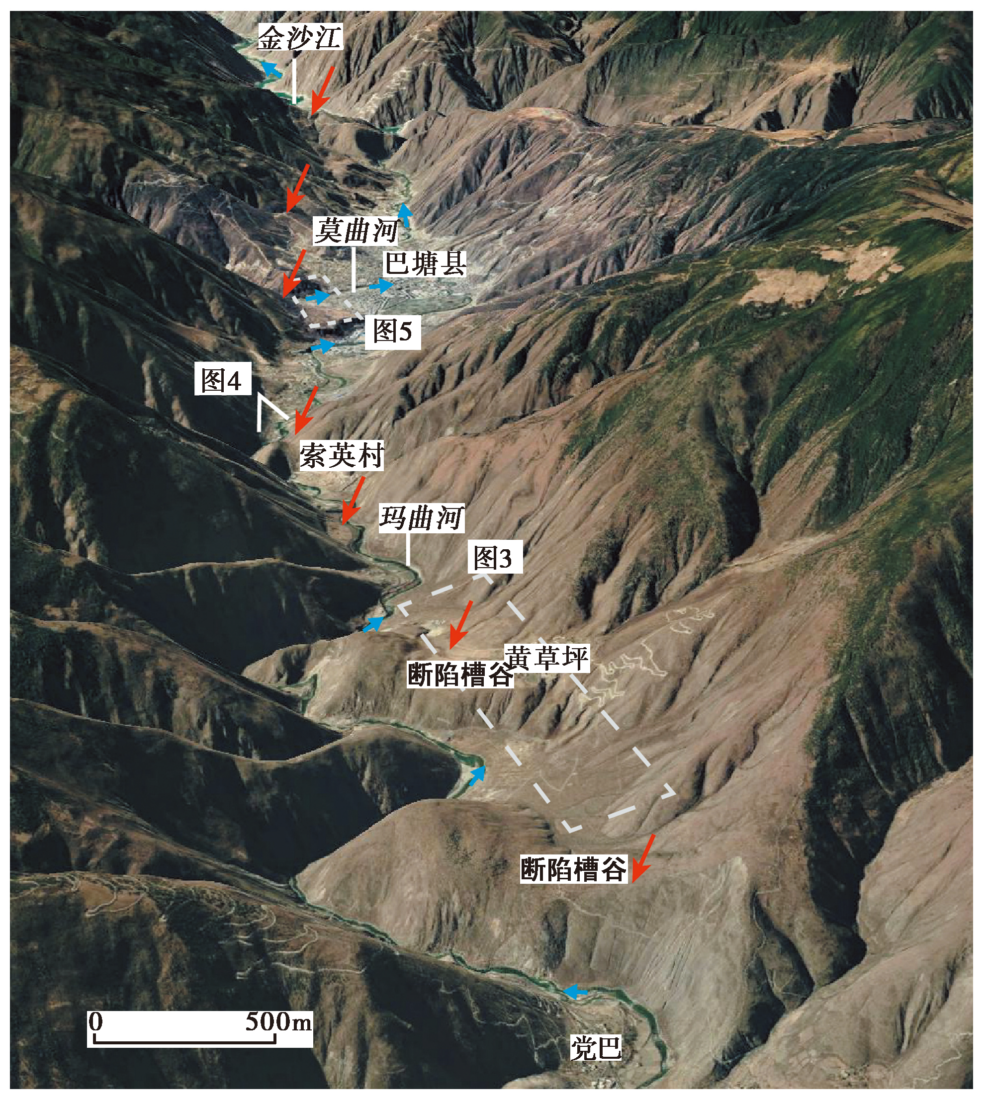
Fig. 2 Distribution characteristics of Batang Fault, Huangcaoping-Batang County seat section.

Fig. 3 Fault characteristics of Huangcaoping section of Batang Fault.
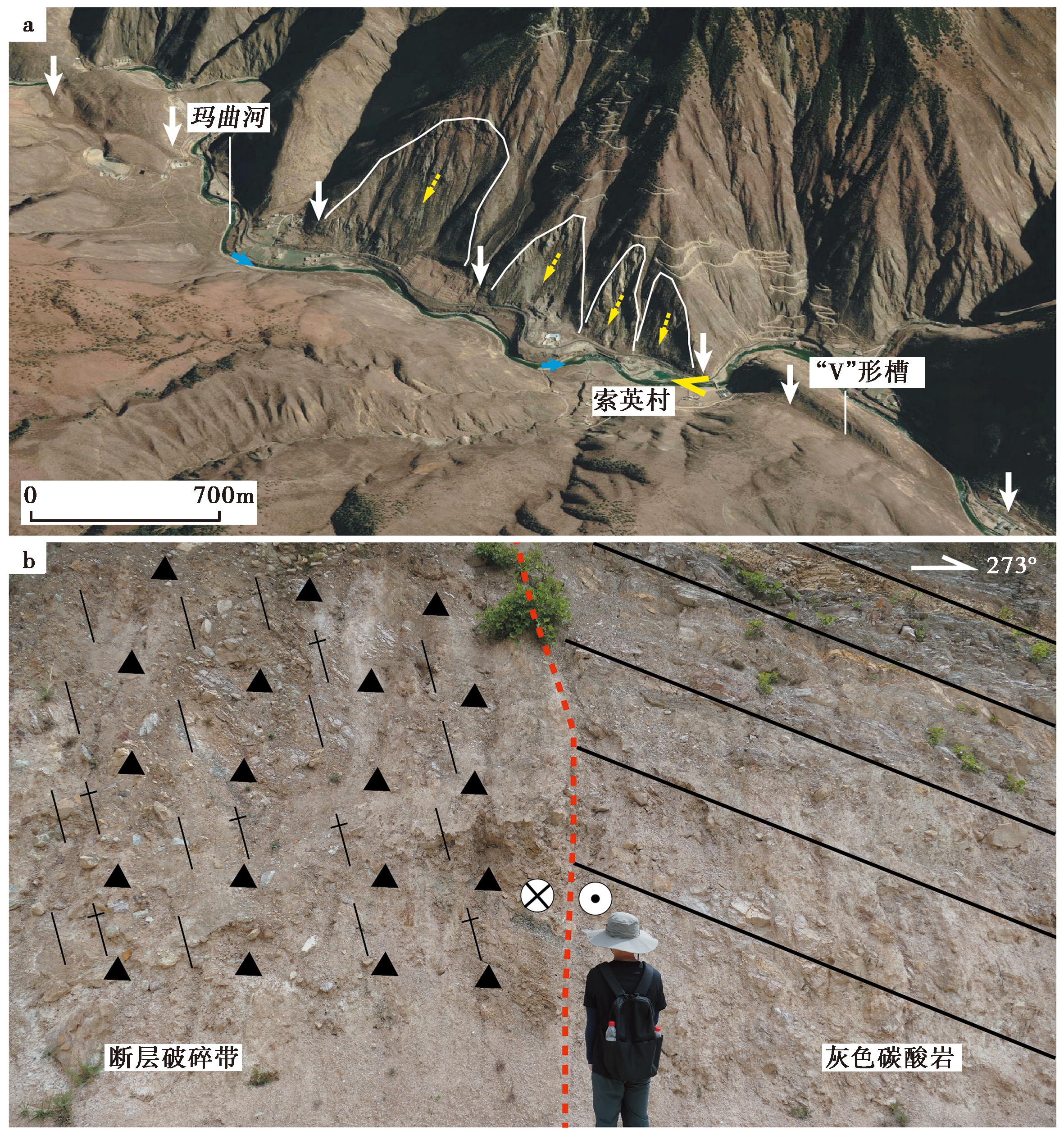
Fig. 4 Linear characteristics and profile of Batang Fault.

Fig. 5 Geomorphic features of Batang County section of Batang Fault.
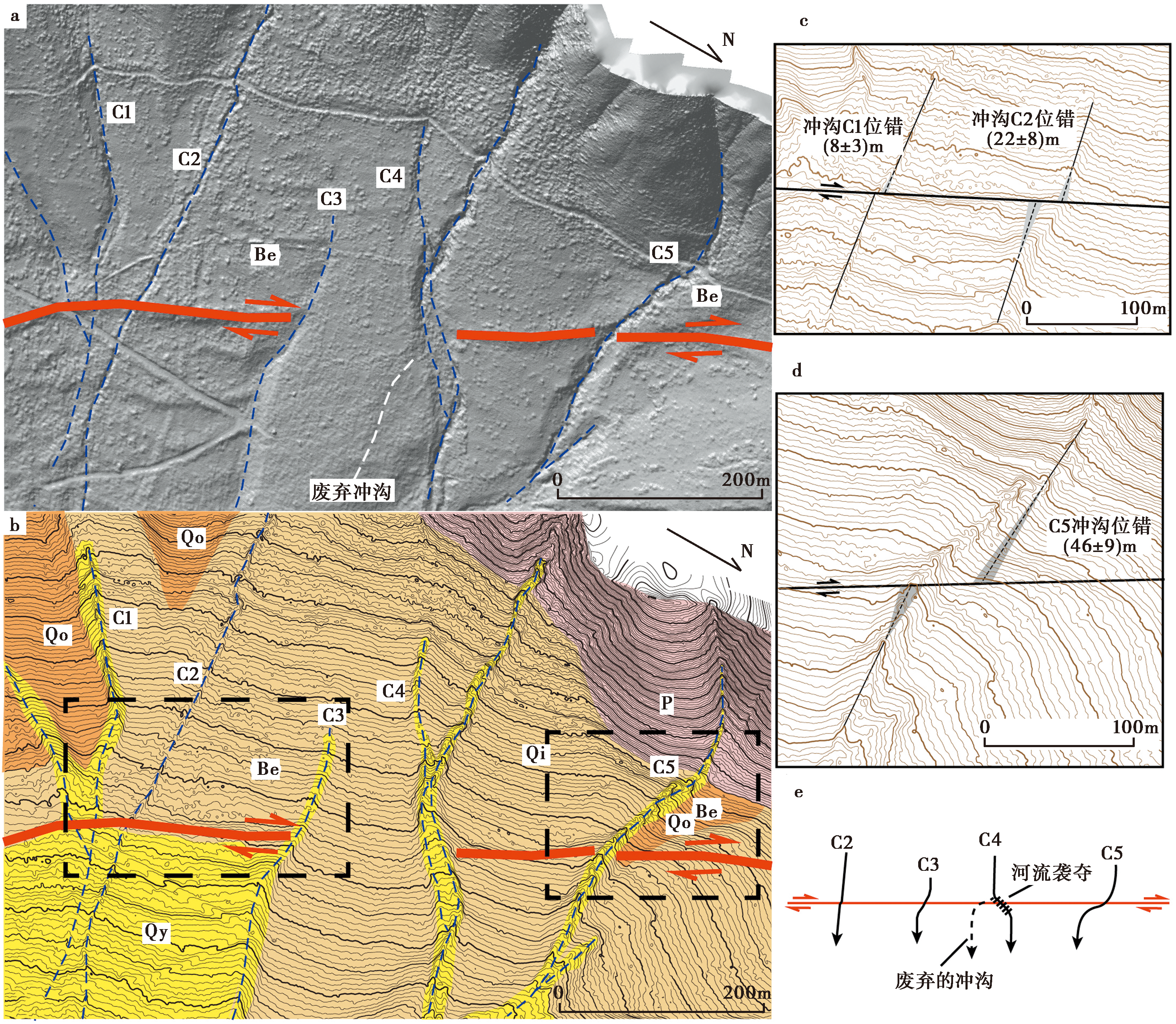
Fig. 6 Horizontal displacement features of the Batang Fault in the Piedmont of Huangcaoping.
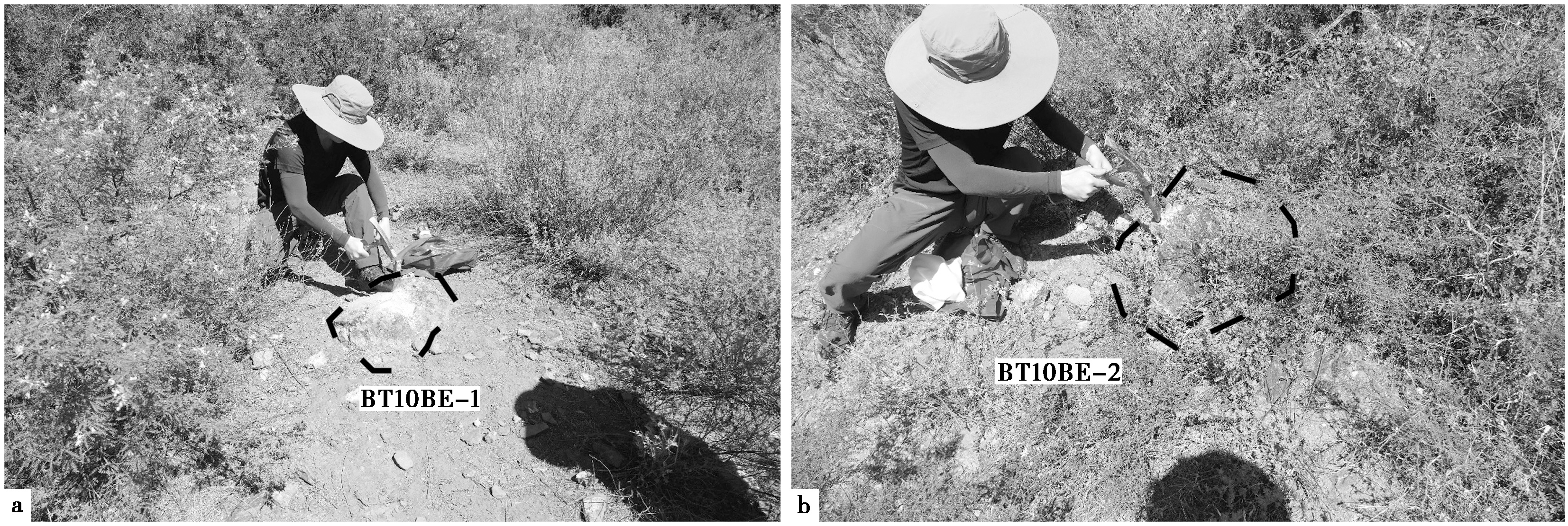
Fig. 7 Cosmogenic nuclide sampling points of large boulders on the alluvial fan in Huangcaoping.

Fig. 8 Fault features on the alluvial fan of Moqu river.
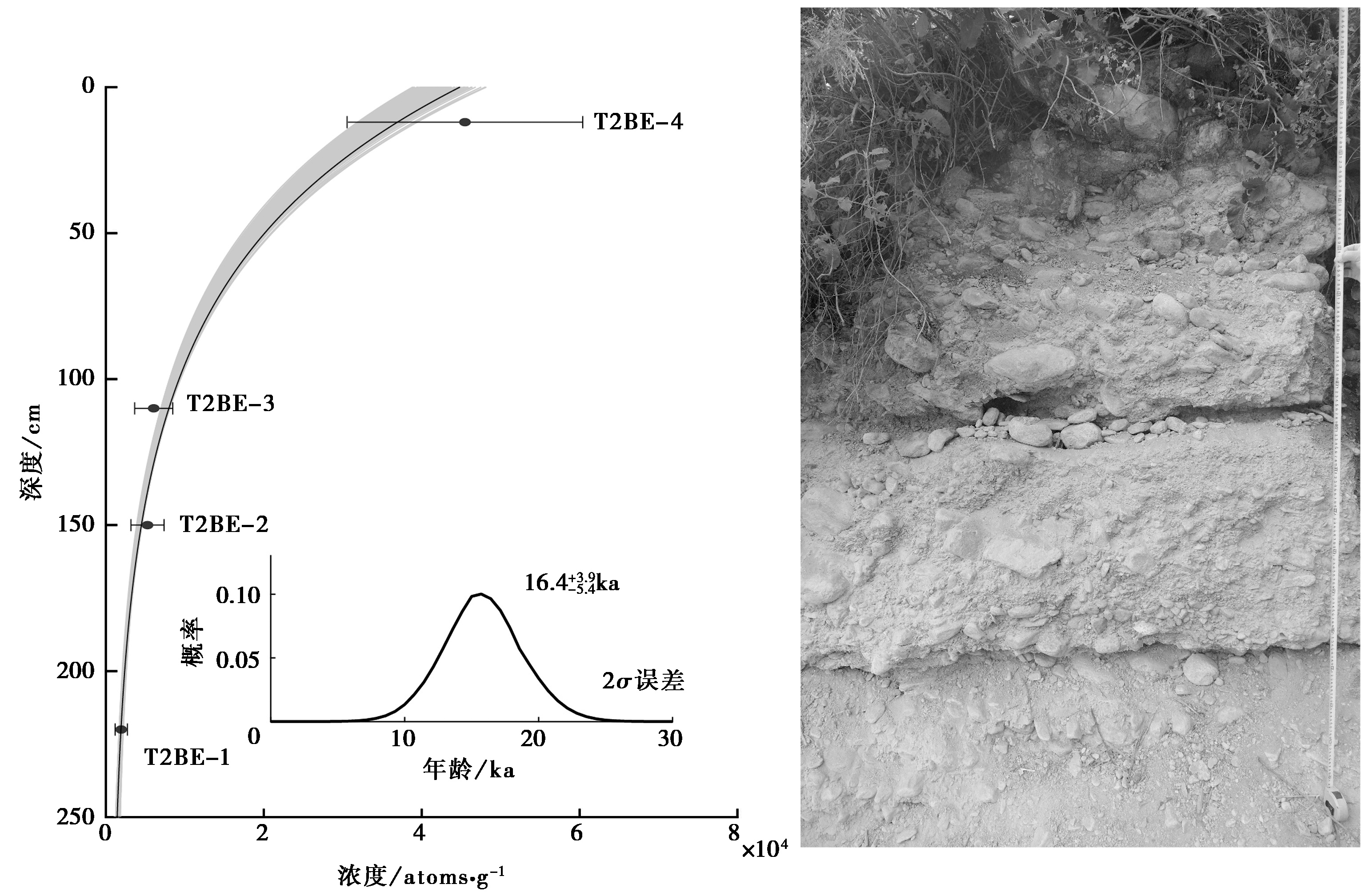
Fig. 9 Age results of the cosmogenic depth profile in the Moqu river alluvial fan.
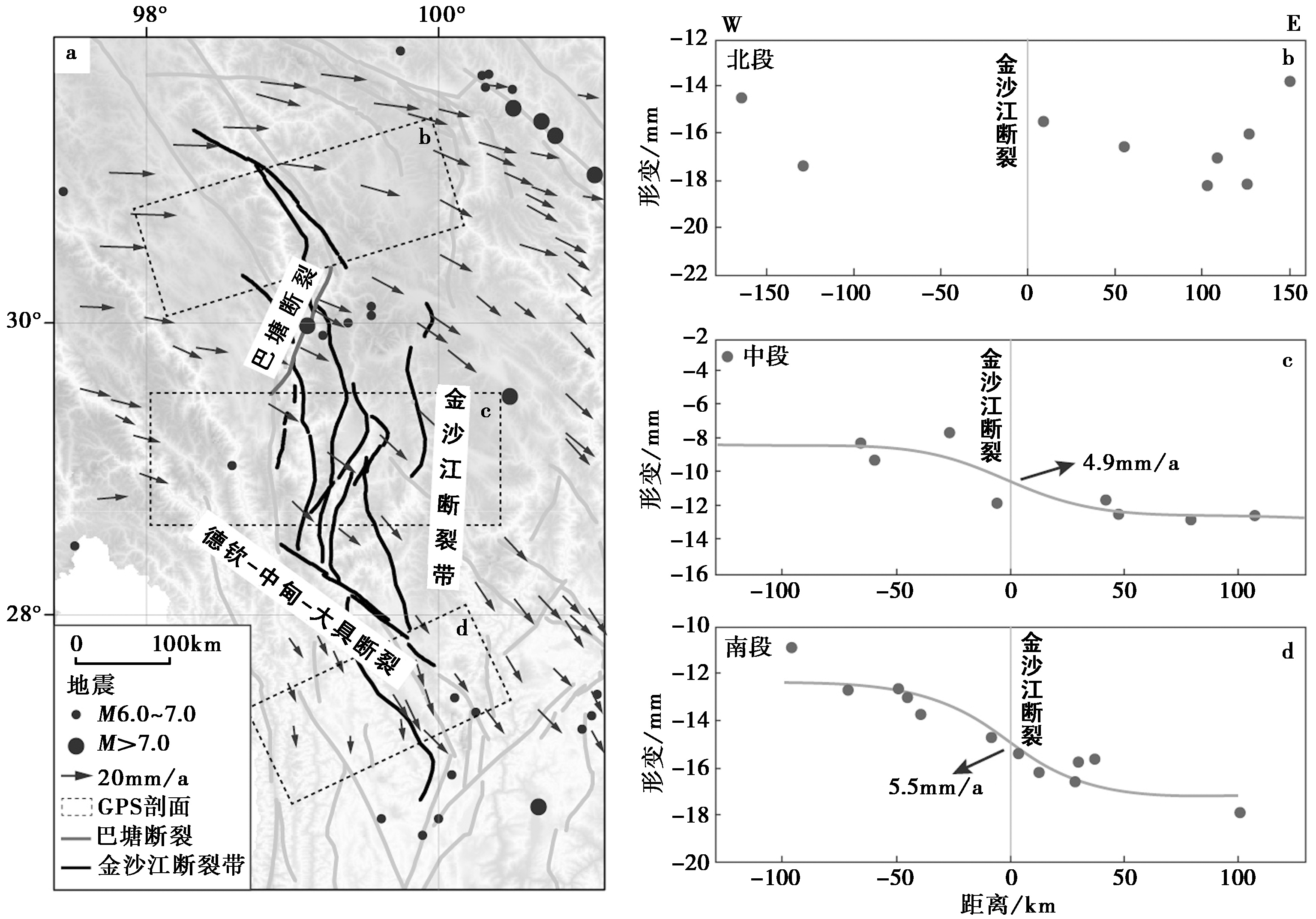
Fig. 10 The GPS horizontal velocity field in the Jinshajiang fault zone and surrounding areas(Modify by XU Xiao-xue et al., 2020).
| [1] |
黄伟亮, 杨晓平, 李胜强, 等. 2018. 天山内部走滑断裂晚第四纪活动特征研究——以开都河断裂为例[J]. 地震地质, 40(5): 1040—1058. doi: 10.3969/j.issn.0253-4967.2018.05.006.
|
|
|
|
| [2] |
黄周传, 吉聪, 吴寒婷, 等. 2021. 青藏高原东南缘地壳结构与变形机制研究进展[J]. 地球与行星物理论评, 52(3): 291—307.
|
|
|
|
| [3] |
李煜航, 郝明, 季灵运, 等. 2014. 青藏高原东缘中南部主要活动断裂滑动速率及其地震矩亏损[J]. 地球物理学报, 57(4): 1062—1078.
|
|
|
|
| [4] |
潘桂棠. 1986. 青藏高原新生代构造演化[M]. 北京: 地质出版社.
|
|
|
|
| [5] |
王立全, 潘桂棠, 李定谋, 等. 1999. 金沙江弧-盆系时空结构及地史演化[J]. 地质学报, 73(3): 206—218.
|
|
|
|
| [6] |
闻学泽. 2018. 巴颜喀拉块体东边界千年破裂历史与2008年汶川、 2013年芦山和2017年九寨沟地震[J]. 地震学报, 40(3): 255—267.
|
|
|
|
| [7] |
翁雪飞, 武振波, 徐涛, 等. 2022. 青藏高原东南缘深部地球物理探测与壳幔结构研究进展[J]. 地球物理学进展, 38(2): 612—630.
|
|
|
|
| [8] |
肖阳, 邬光辉, 雷永良, 等. 2017. 走滑断裂带贯穿过程与发育模式的物理模拟[J]. 石油勘探与开发, 44(3): 340—348.
DOI |
|
|
|
| [9] |
徐锡伟, 陈桂华. 2018. 活动断层避让问题探讨与建议[J]. 城市与减灾, (1): 8—13.
|
|
|
|
| [10] |
徐锡伟, 闻学泽, 郑荣章, 等. 2003. 川滇地区活动块体最新构造变动样式及其动力来源[J]. 中国科学(D辑), 33(S1): 151—162.
|
|
|
|
| [11] |
徐锡伟, 张培震, 闻学泽, 等. 2005. 川西及其邻近地区活动构造基本特征与强震复发模型[J]. 地震地质, 27(3): 446—461. doi: 10.3969/j.issn.0253-4967.2005.03.010.
|
|
|
|
| [12] |
徐晓雪, 季灵运, 蒋锋云, 等. 2020. 基于 GPS 和小震研究金沙江断裂带现今活动特征[J]. 大地测量与地球动力学, 40(10): 1062—1067.
|
|
|
|
| [13] |
许志琴, 王宗秀, 侯立玮. 1991. 松潘-甘孜造山带构造研究新进展[J]. 中国地质, 18(12): 14—16.
|
|
|
|
| [14] |
张波, 张进江, 钟大赉, 等. 2009. 滇西澜沧江构造带及邻区几何学、 运动学和构造年代学分析[J]. 地质科学, 44(3): 889—909.
|
|
|
|
| [15] |
钟大赉, 丁林, 刘福田, 等. 2000. 造山带岩石层多向层架构造及其对新生代岩浆活动制约: 以三江及邻区为例[J]. 中国科学(D辑), 30(S1): 1—8.
|
|
|
|
| [16] |
周荣军, 陈国星, 李勇, 等. 2005. 四川西部理塘—巴塘地区的活动断裂与1989年巴塘6.7级震群发震构造研究[J]. 地震地质, 27(1): 31—43.
|
|
|
|
| [17] |
|
| [18] |
|
| [19] |
|
| [20] |
|
| [21] |
|
| [22] |
|
| [23] |
|
| [24] |
|
| [25] |
|
| [26] |
|
| [27] |
|
| [28] |
|
| [29] |
|
| [30] |
|
| [31] |
|
| [32] |
|
| [33] |
|
| [34] |
|
| [35] |
|
| [36] |
|
| [37] |
|
| [38] |
|
| [39] |
|
| [40] |
|
| [41] |
|
| [42] |
|
| [43] |
|
| [44] |
|
| [45] |
|
| [46] |
|
| [47] |
|
| [48] |
PMID |
| [49] |
|
| [50] |
|
| [51] |
|
| [52] |
|
| [53] |
|
| [54] |
|
| [55] |
|
| [56] |
|
| [57] |
|
| [1] | CHANG Yu-qiao, ZHANG Hui-ping, ZHAO Xu-dong. RESEARCH ADVANCES OF THE LATE QUATERNARY ACTIVITY OF XIAOJIANG FAULT ZONE IN THE SOUTHEASTERN MARGIN OF QINGHAI-XIZANG PLATEAU [J]. SEISMOLOGY AND GEOLOGY, 2026, 48(2): 279-313. |
| [2] | XU Wei, LI Guang-tao, CHENG Li, ZOU Zi-nan. LATE QUATERNARY ACTIVITY CHARACTERISTICS IN THE SHIBAN RIVER TO NANNIWAN SEGMENT OF THE SOUTHERN MAOMAOSHAN MARGINAL FAULT [J]. SEISMOLOGY AND GEOLOGY, 2026, 48(2): 386-402. |
| [3] | LUO Jia-xin, LI Bin, LI Zi-hong, FAN Kun. CHARACTERISTICS OF VERTICAL SLIP RATE EVOLUTION ALONG THE JIAOCHENG FAULT ZONE, SHANXI, SINCE LATE PLEISTOCENE [J]. SEISMOLOGY AND GEOLOGY, 2026, 48(1): 43-63. |
| [4] | CHEN Yan-wen, YUAN Dao-yang, YAO Yun-sheng, YU Jin-chao, WEN Ya-meng, SU Rui-huan, SUN Hao. CHARACTERISTICS OF LATE QUATERNARY ACTIVITY AND TECTONIC IMPLICATIONS OF THE MAYAXUESHAN FAULT IN THE EASTERN QILIAN SHAN [J]. SEISMOLOGY AND GEOLOGY, 2025, 47(6): 1566-1585. |
| [5] | GAO Yang, WU Zhong-hai, HAN Shuai, TIAN Ting-ting. LATE QUATERNARY THROW RATE OF THE SEISMOGENIC FAULT(DENGMECUO FAULT)OF THE 2025 MS6.8 DINGRI EARTHQUAKE IN SHIGATSE [J]. SEISMOLOGY AND GEOLOGY, 2025, 47(3): 689-706. |
| [6] | WANG Duo, CHEN Li-chun, LI Yan-bao, WANG Hu, JIA Yong-shun, GAO Yin-yi, XUE Ke-yi. LATE QUATERNARY ACTIVITY OF THE XIETONGMEN TO DENGMECUO SEGMENT ALONG THE XAINZA-DINGGYE RIFT IN SOUTHERN QINGHAI-XIZANG PLATEAU [J]. SEISMOLOGY AND GEOLOGY, 2025, 47(3): 718-733. |
| [7] | CHEN Chang-yun, YIN Hai-quan. CRUSTAL DEFORMATION CHARACTERISTICS AND PROBABILITY PREDICTION OF STRONG EARTHQUAKE RISK IN XINJIANG AND ITS ADJACENT REGION [J]. SEISMOLOGY AND GEOLOGY, 2025, 47(2): 384-404. |
| [8] | ZHU Shuang, GUO Nan-nan, PANG Ya-jin. STUDY ON FAULT DEFORMATION CHARACTERISTICS AND SEISMIC HAZARD IN THE KEPING THRUST BELT [J]. SEISMOLOGY AND GEOLOGY, 2025, 47(2): 448-462. |
| [9] | LI Jin, DENG Ming-wen, ZHANG Zhi-guang, SUN Ye-jun, YAO Yuan, XU Kai-chi. PRELIMINARY STUDY ON THE SEISMOGENIC STRUCTURE OF THE 2024 M5 EARTHQUAKE SWARM IN YULI, TARIM BASIN [J]. SEISMOLOGY AND GEOLOGY, 2025, 47(2): 463-487. |
| [10] | XU Bin-bin, ZHANG Yi-peng, LU Le-jun, TIAN Qing-ying, YANG Xue, WANG Yang, ZHANG Pei-zhen. STUDY ON SEISMOGENIC TECTONICS OF THE 2025 MYANMAR MS7.9 EARTHQUAKE [J]. SEISMOLOGY AND GEOLOGY, 2025, 47(2): 649-670. |
| [11] | ZANG Ke-zhi, WU Chuan-yong, ZHANG Jin-shuo, GAO Zhan, YUAN Si-hua, YUAN Hai-yang, YU Xiao-hui, WANG Xue-zhu. LATE QUATERNARY DEFORMATION RATE OF THE WENSU FORELAND THRUST BELT IN THE SOUTHERN TIANSHAN MOUNTAINS [J]. SEISMOLOGY AND GEOLOGY, 2024, 46(6): 1280-1294. |
| [12] | HUA Chun-yu, SHI Feng, WEI Zhan-yu. STUDY ON THE SLIP RATE OF THE BAISHA RIVER SEGMENT IN THE YINGXIU-BEICHUAN FAULT IN THE LONGMENSHAN FAULT ZONE [J]. SEISMOLOGY AND GEOLOGY, 2024, 46(6): 1295-1313. |
| [13] | ZHANG Hao, HUANG Wei-liang, XIANG Wen, YANG Qian-hao, LIU Bo. LATE QUATERNARY DEPOSITION AND INCISION SEQUENCES OF THE BAQU RIVER AND THEIR EXPERIMENTAL IMPLICATION [J]. SEISMOLOGY AND GEOLOGY, 2024, 46(3): 570-588. |
| [14] | CHEN Bai-xu, YU Zhong-yuan, XIAO Peng, DAI Xun-ye, ZHANG Shi-long, ZHENG Rong-ying. THE NEW FINDINGS OF SURFACE RUPTURE ZONES AND ITS SEISMOLOGICAL SIGNIFICANCE OF THE EASTERN MARGIN OF YUMUSHAN FAULT, NORTHEASTERN MARGIN OF QINGZANG PLATEAU [J]. SEISMOLOGY AND GEOLOGY, 2024, 46(3): 589-607. |
| [15] | WANG Hui, CAO Jian-ling, YAO Qi, WANG Li-wei, ZHU Ya-ling. EFFECTS OF STRIKE-SLIP FAULT GEOMETRIC COMPLEXITY ON EARTHQUAKE RUPTURES PROPAGATION: A REVIEW [J]. SEISMOLOGY AND GEOLOGY, 2024, 46(1): 201-219. |
| Viewed | ||||||
|
Full text |
|
|||||
|
Abstract |
|
|||||
Copyright © SEISMOLOGY AND GEOLOGY, All Rights Reserved.
Tel: 010-62009049/9063 E-mail: dzdz@ies.ac.cn
Powered by Beijing Magtech Co., Ltd.