SEISMOLOGY AND GEOLOGY ›› 2024, Vol. 46 ›› Issue (1): 117-140.DOI: 10.3969/j.issn.0253-4967.2024.01.008
Previous Articles Next Articles
LI Hao-feng( ), XU Yue-ren*(), GUO Ya-li, LIU Han, ZHAO Xin-yu, LU Ling-yu, TANG Jia-cheng
Received:2023-10-16
Revised:2023-12-08
Online:2024-02-20
Published:2024-03-22
李浩峰(), 徐岳仁*(), 郭雅丽, 刘晗, 赵昕雨, 陆玲玉, 唐嘉诚
通讯作者:
*徐岳仁, 男, 1981年生, 研究员, 主要从事地震地质研究, E-mail: 作者简介:李浩峰, 男, 1998年生, 现为中国地震局地震预测研究所构造地质学专业在读硕士研究生, 主要从事强震触发次生灾害研究, E-mail: lihaofeng@ief.ac.cn。
基金资助:LI Hao-feng, XU Yue-ren, GUO Ya-li, LIU Han, ZHAO Xin-yu, LU Ling-yu, TANG Jia-cheng. REMOTE SENSING INTEPRETATION OF COSEISMIC LAND-SLIDES TRIGGERED BY 1976 LONGLING MS7.3 AND MS7.4 EARTHQUAKES AND THE TECTONIC SIGNIFICANCES[J]. SEISMOLOGY AND GEOLOGY, 2024, 46(1): 117-140.
李浩峰, 徐岳仁, 郭雅丽, 刘晗, 赵昕雨, 陆玲玉, 唐嘉诚. 滇西南1976年龙陵MS7.3、MS7.4 双强震触发滑坡遥感解译及其构造意义[J]. 地震地质, 2024, 46(1): 117-140.
Add to citation manager EndNote|Ris|BibTeX
URL: https://www.dzdz.ac.cn/EN/10.3969/j.issn.0253-4967.2024.01.008
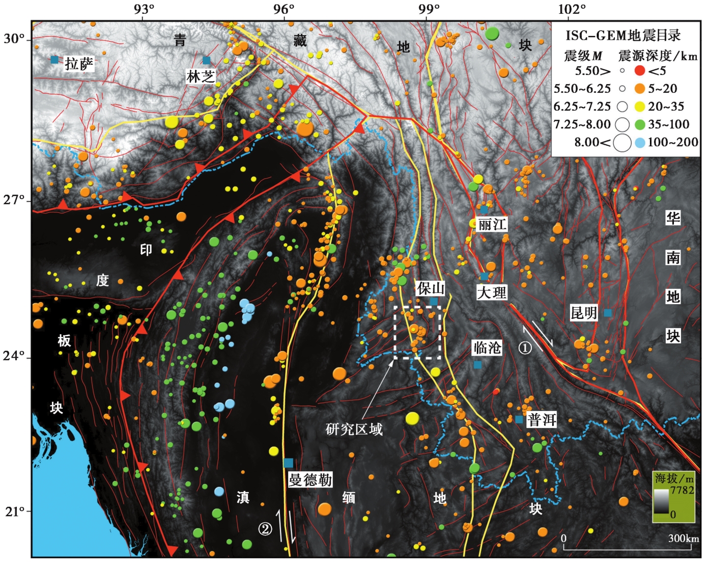
Fig. 1 Tectonic settings of the study area.
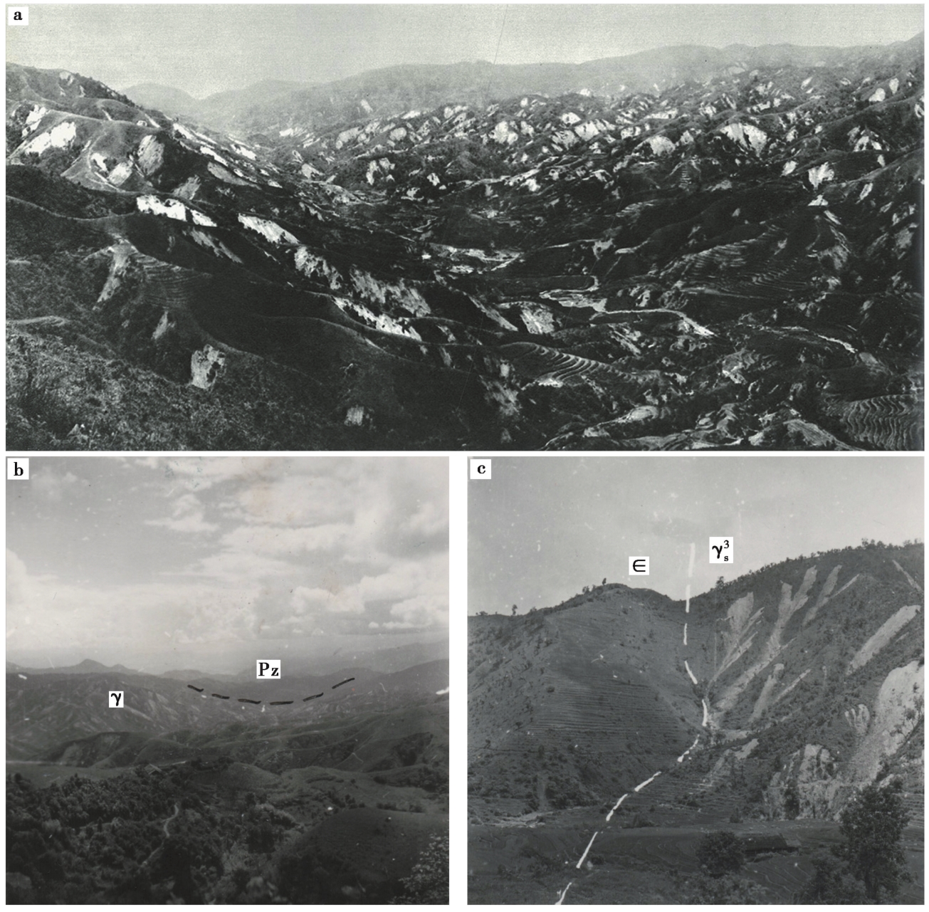
Fig. 2 Photos taken after 1976 Longling earthquake.
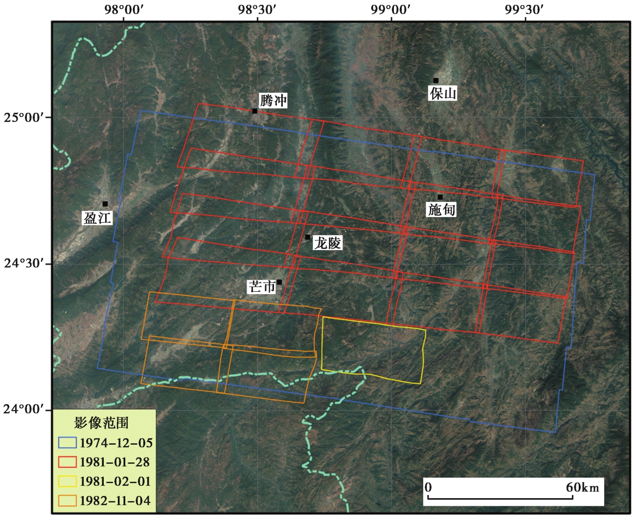
Fig. 3 Coverage areas and timescale of Keyhole satellite images used in this study.
| 卫星名称 | 任务编号 | 发射日期 | 运载火箭 | 幅宽/km | 回收日期 | 拍摄日期 | 分辨率 |
|---|---|---|---|---|---|---|---|
| KH9-9 | 1209 | 1974年10月29日 | 泰坦IIID | 162.0×271.0 | 1975年3月9日 | 1974年12月5日 | 0.6~1.2m |
| KH9-16 | 1216 | 1980年6月18日 | 泰坦IIID | 169.0×265.0 | 1981年3月6日 | 1981年1月28日、2月1日 | 0.6~1.2m |
| KH9-17 | 1217 | 1981年5月11日 | 泰坦IIID | 177.0×262.0 | 1982年12月5日 | 1982年11月4日 | 0.6~1.2m |
Table1 Parameters of Keyhole satellite images used in this study
| 卫星名称 | 任务编号 | 发射日期 | 运载火箭 | 幅宽/km | 回收日期 | 拍摄日期 | 分辨率 |
|---|---|---|---|---|---|---|---|
| KH9-9 | 1209 | 1974年10月29日 | 泰坦IIID | 162.0×271.0 | 1975年3月9日 | 1974年12月5日 | 0.6~1.2m |
| KH9-16 | 1216 | 1980年6月18日 | 泰坦IIID | 169.0×265.0 | 1981年3月6日 | 1981年1月28日、2月1日 | 0.6~1.2m |
| KH9-17 | 1217 | 1981年5月11日 | 泰坦IIID | 177.0×262.0 | 1982年12月5日 | 1982年11月4日 | 0.6~1.2m |
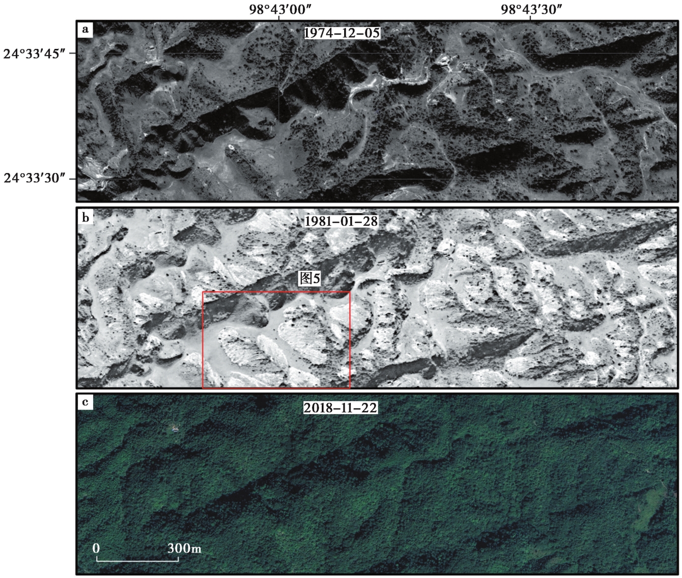
Fig. 4 Comparison of Keyhole images before and after the Longling earthquakes, with recent Maxar images from Google Earth.
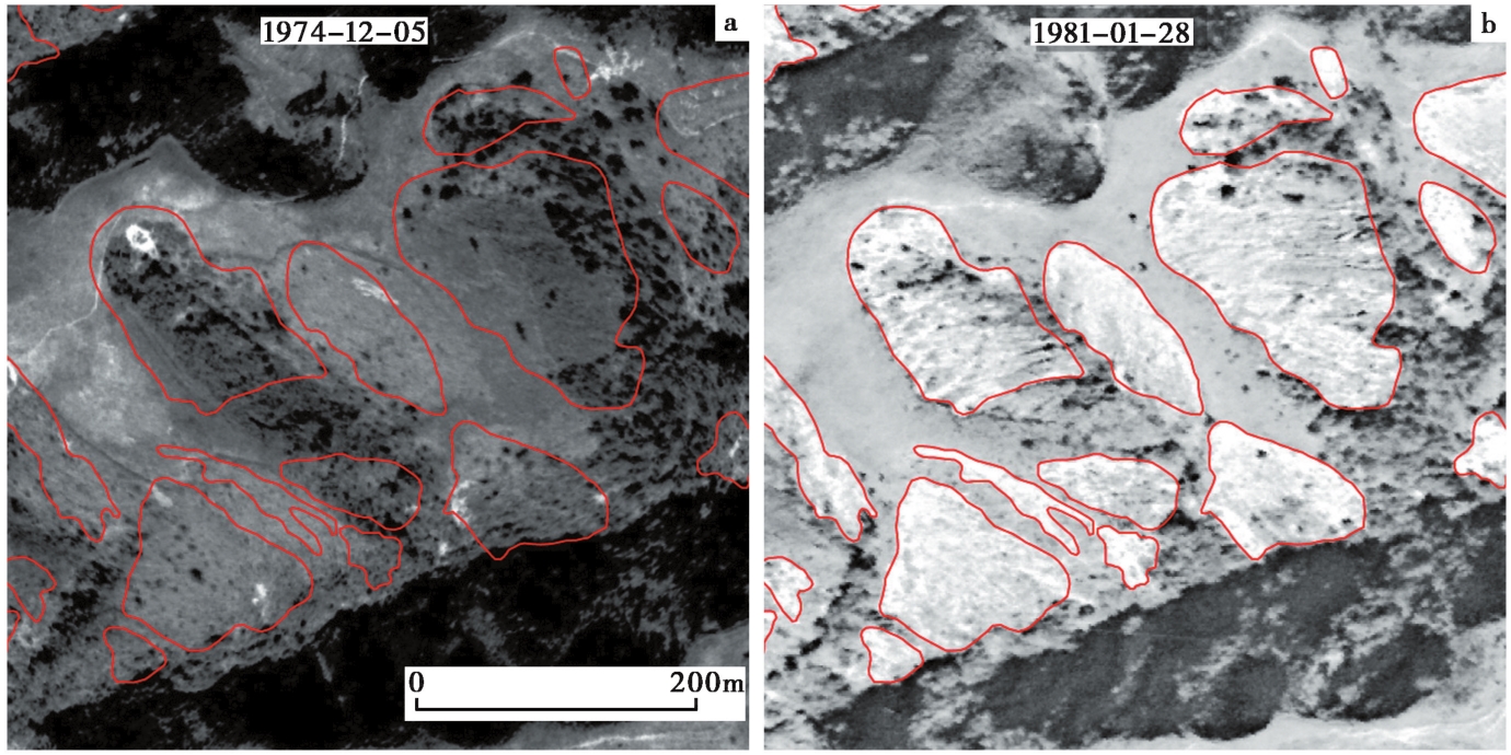
Fig. 5 Landslides interpreted through pre- and post-earthquake high-spatial-resolution satellite imagery.
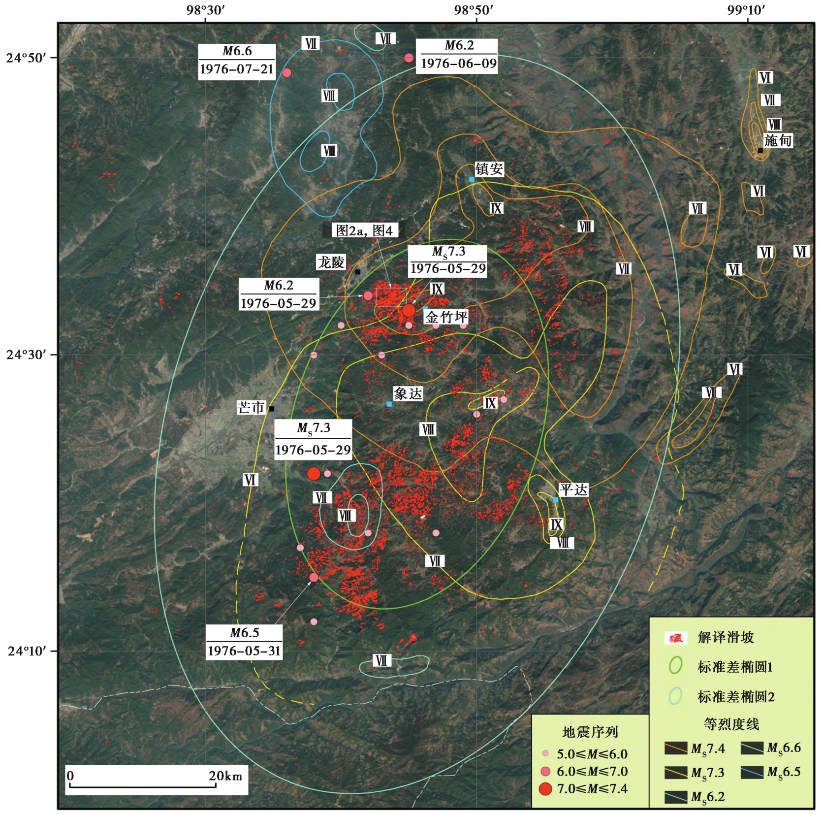
Fig. 6 Interpreted spatial distribution of coseismic landslides induced by 1976 Longling earthquakes.
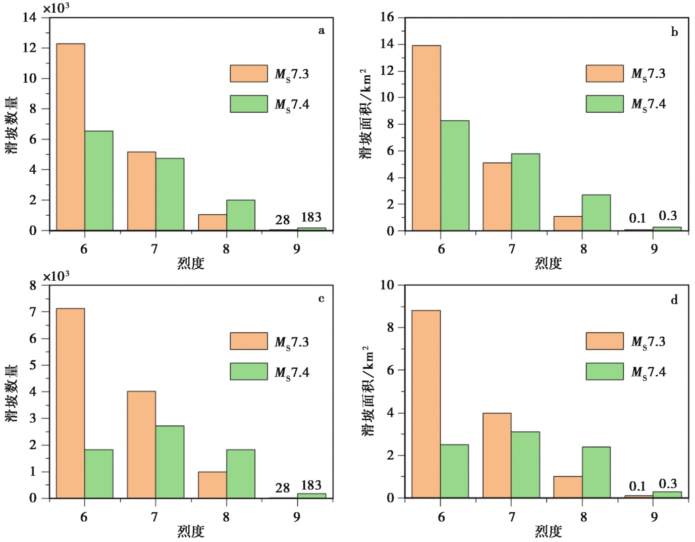
Fig. 7 Histograms showing landslides distribution in earthquake-intensity areas of 1976 Longling MS7.3 and MS7.4 earthquakes.
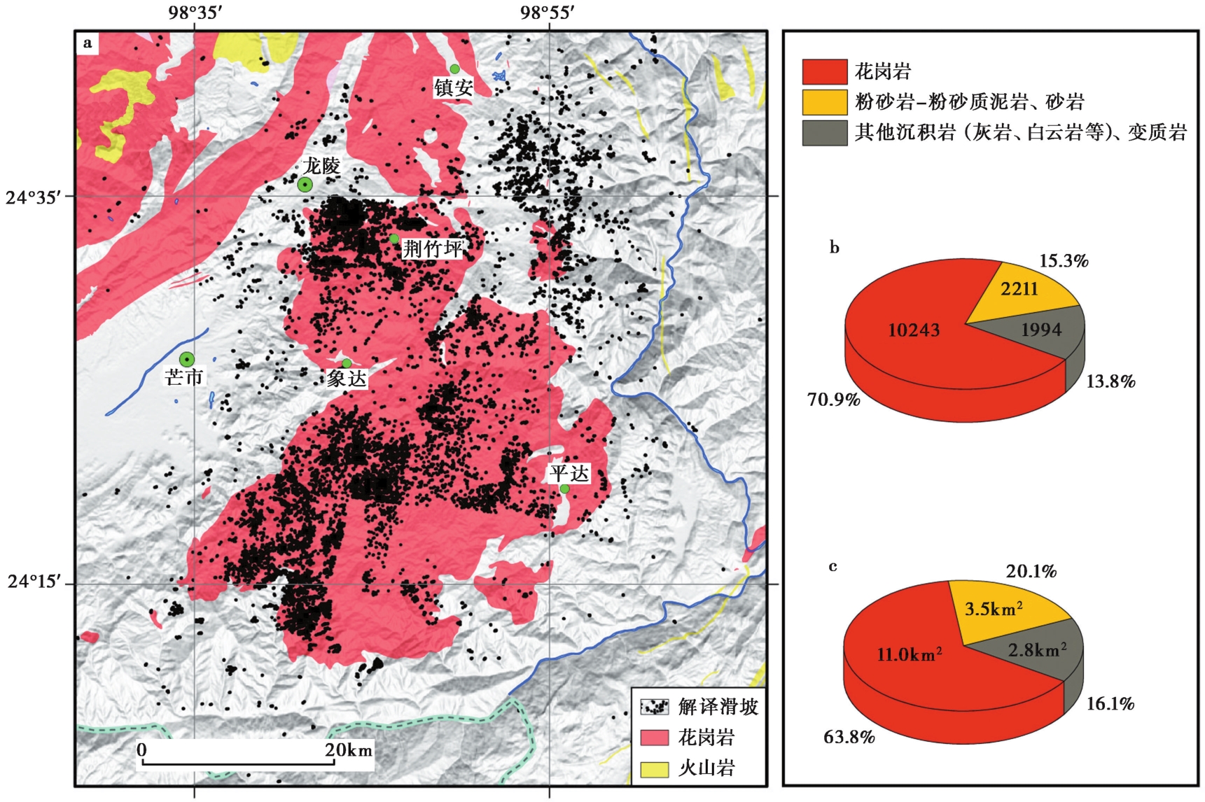
Fig. 8 Relationship between earthquake-triggered landslides and regional lithology.
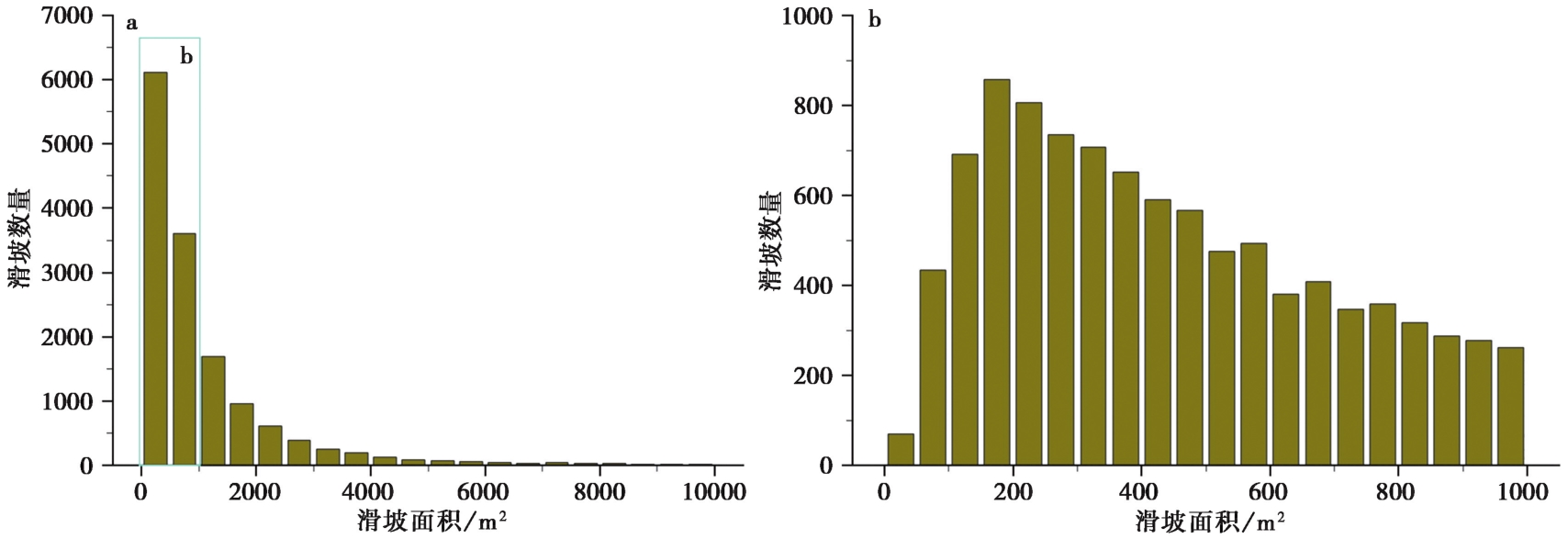
Fig. 9 Histograms showing frequency distribution of single slide area.
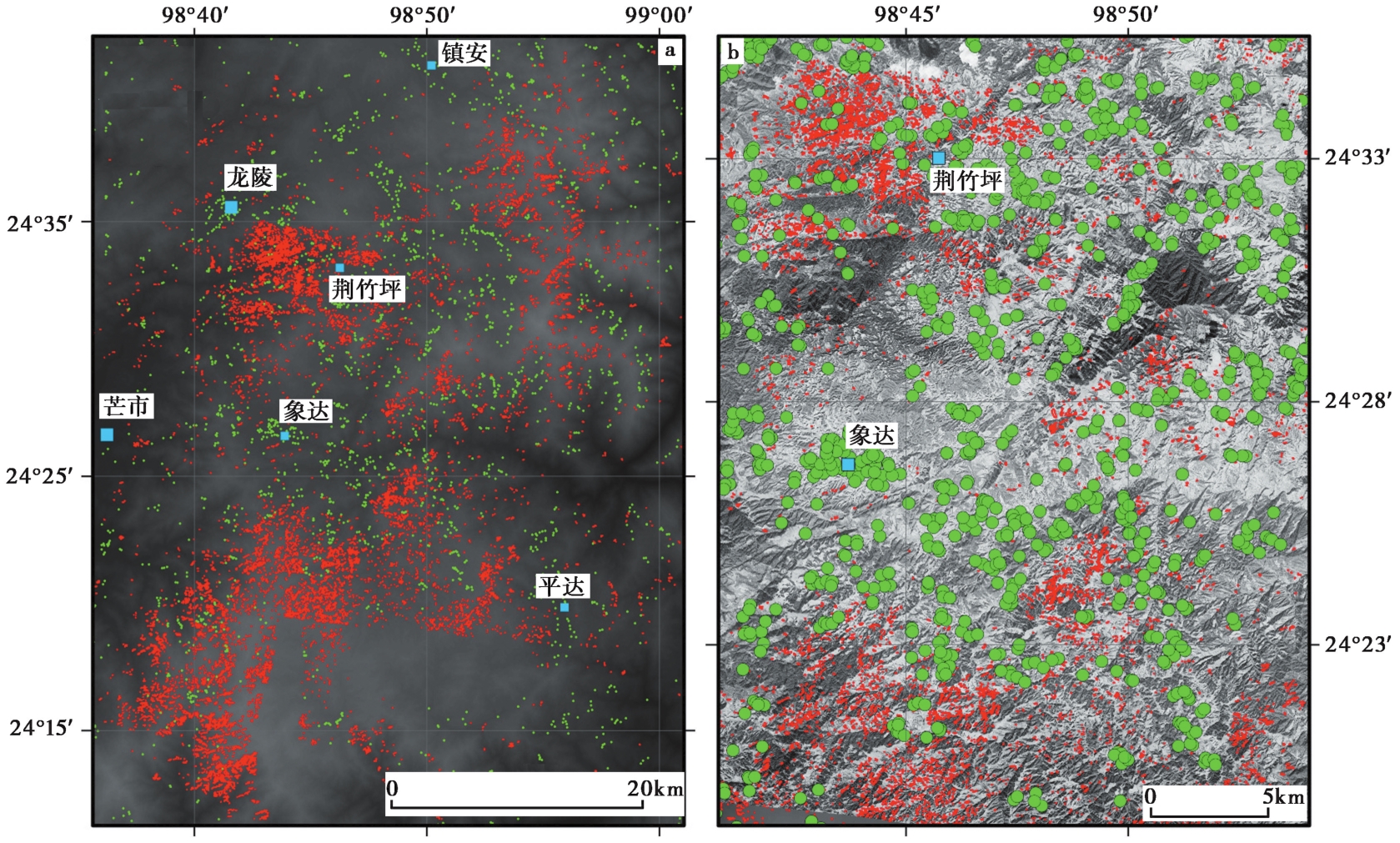
Fig. 10 Interpreted spatial distribution of landslides and residence sites.
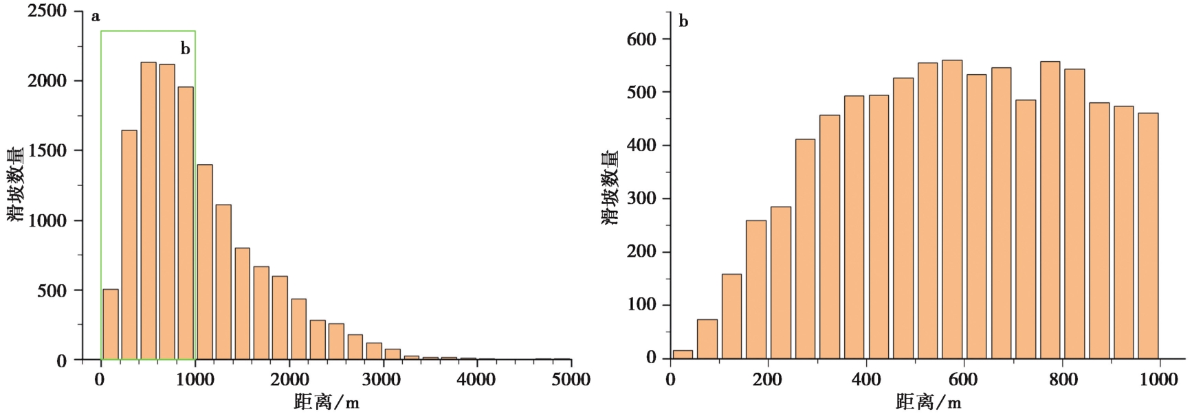
Fig. 11 Histograms showing frequency distribution of distance of earthquake-triggered landslides to residence sites.
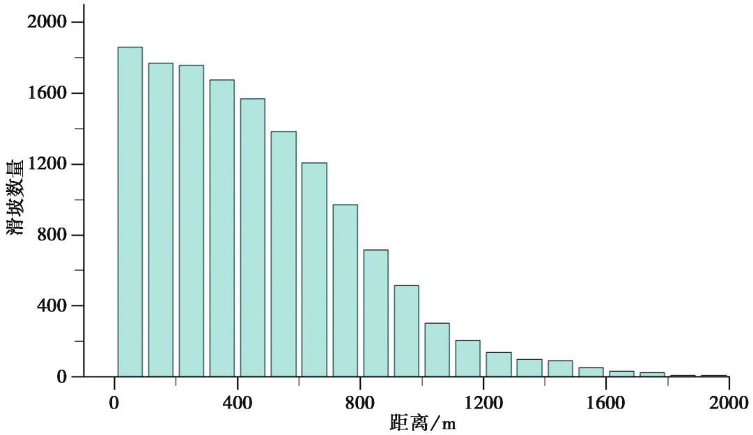
Fig. 12 Histogram showing frequency distribution of distance of earthquake-triggered landslides to drainage system.
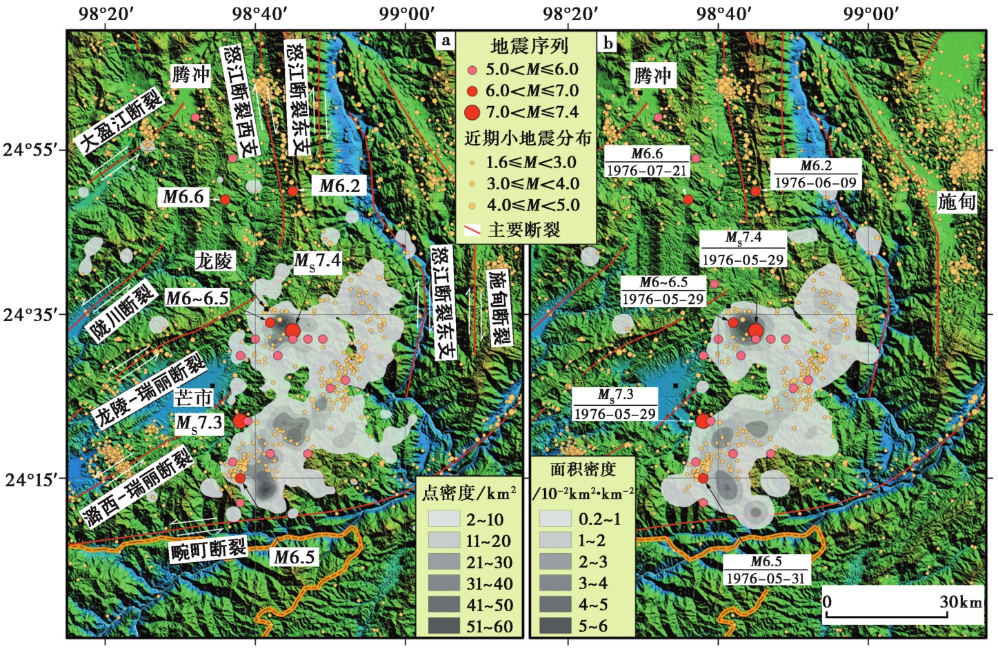
Fig. 13 Interpreted point and areal densities of coseismic landslides, and aftershock sequence from Jan. 2009 to Apr. 2023.

Fig. 14 Distribution of strong historical earthquakes and major active faults in southwestern Yunnan.
| [1] |
安晓文, 常祖峰, 石静芳. 2009. 大盈江断裂西南段晚第四纪活动研究[J]. 地震研究, 32(2): 193—197.
|
|
|
|
| [2] |
包林海, 王成虎, 王显军. 2015. 龙陵-瑞丽断裂北段现今地应力特征及其活动性分析[J]. 华南地震, 35(4): 104—110.
|
|
|
|
| [3] |
常祖峰, 安晓文, 张艳凤. 2012. 畹町断裂晚第四纪活动与水系构造变形[J]. 地震地质, 34(2): 228—239. doi: 10.3969 /j.issn.0253-4967.2012.02.003.
|
|
DOI |
|
| [4] |
常祖峰, 常昊, 毛泽斌, 等. 2021. 中缅交界苏典断裂的最新活动特征及意义[J]. 地震地质, 43(3): 559—575. doi: 10.3969/j.issn.0253-4967.2021.03.006.
|
|
DOI |
|
| [5] |
常祖峰, 陈刚, 余建强. 2011. 大盈江断裂晚更新世以来活动的地质证据[J]. 地震地质, 33(4): 877—888. doi: 10.3969 /j.issn.0253-4967.2011.04.012.
|
|
DOI |
|
| [6] |
陈金海, 晏凤桐, 韩新民, 等. 1979. 龙陵地震前兆异常特征及其前兆场理论的初探[J]. 地震研究, 2(1): 1—10.
|
|
|
|
| [7] |
陈立德. 1982. 龙陵地震前兆及其时空演变特征[J]. 地震, 2(4): 2—6.
|
|
|
|
| [8] |
陈立德. 1980. 龙陵地震前兆特征的物理机制讨论[J]. 地震研究, 3(1): 22—29.
|
|
|
|
| [9] |
陈立德, 赵维城. 1979. 一九七六年龙陵地震[M]. 北京: 地震出版社.
|
|
|
|
| [10] |
陈小斌, 叶涛, 蔡军涛, 等. 2019. 大地电磁资料精细处理和二维反演解释技术研究(七): 云南盈江—龙陵地震区深部电性结构及孕震环境[J]. 地球物理学报, 62(4): 1377—1393.
DOI |
|
|
|
| [11] |
陈晓利, 冉洪流, 祁生文. 2009. 1976年龙陵地震诱发滑坡的影响因子敏感性分析[J]. 北京大学学报(自然科学版), 45(1): 104—110.
|
|
|
|
| [12] |
戴雨芡, 皇甫岗, 白仙富. 2017. 畹町断裂带地貌特征及构造意义指示[J]. 地震研究, 40(1): 129—137.
|
|
|
|
| [13] |
杜义, 张效亮, 黄学猛, 等. 2012. 龙陵-瑞丽断裂北段晚第四纪活动性特征及强震复发间隔[J]. 震灾防御技术, 7(3): 215—226.
|
|
|
|
| [14] |
方良好, 袁道阳, 邵延秀, 等. 2015a. 云南西南部黑河断裂晚第四纪分段活动特征[J]. 地震研究, 38(4): 558—567.
|
|
|
|
| [15] |
方良好, 袁道阳, 邵延秀, 等. 2013. 滇西南地区黑河断裂中西段晚第四纪构造活动特征[J]. 地震工程学报, 35(2): 342—353.
|
|
|
|
| [16] |
方良好, 袁道阳, 邵延秀, 等. 2015b. 滇西南地区黑河断裂西段古地震形变带特征[J]. 震灾防御技术, 10(2): 271—280.
|
|
|
|
| [17] |
高效东, 王爱国, 袁道阳, 等. 2020. 滇西南打洛断裂晚第四纪活动特征[J]. 地震工程学报, 42(1): 157—167.
|
|
|
|
| [18] |
国家地震局地质研究所. 1983. 中国八大地震震害摄影图集[CM]. 北京: 地震出版社.
|
|
Institute of Geology, State Seismological Bureau. 1983. The photo album of eight strong earthquake disasters in China[CM]. Seismological Press, Beijing (in Chinese).
|
|
| [19] |
虢顺民, 向宏发, 徐锡伟, 等. 2000. 滇西南龙陵-澜沧第四纪新生断裂带特征和形成机制研究[J]. 地震地质, 22(3): 277—284.
|
|
|
|
| [20] |
虢顺民, 向宏发, 周瑞琦, 等. 1999. 滇西南龙陵-澜沧断裂带: 大陆地壳上一条新生的破裂带[J]. 科学通报, 44(19): 2118—2121.
|
|
|
|
| [21] |
韩明明. 2022. 怒江断裂带邦达段晚第四纪活动性研究[D]. 北京: 中国地震局地质研究所.
|
|
|
|
| [22] |
韩新民, 赵维城. 1979. 龙陵地震的4个九度区: 双共轭型极震区[J]. 地震研究, 2(1): 20—24.
|
|
|
|
| [23] |
郝明, 王庆良, 崔笃信, 等. 2013. 滇西南龙陵-澜沧断裂带现今地壳垂直运动研究[J]. 地震研究, 36(3): 281—285.
|
|
|
|
| [24] |
贺根文, 付碧宏, 刘鸣, 等. 2014. 龙陵-瑞丽断裂带附近的构造地貌与断裂活动性[J]. 地震地质, 36(2): 434—448. doi: 10.3969 /j.issn.0253-4967.2014.02.013.
|
|
|
|
| [25] |
何文贵, 刘兴旺, 袁道阳, 等. 2015. 滇西南地区孟连断裂晚第四纪新活动特征初步研究[J]. 地震工程学报, 37(4): 986—995.
|
|
|
|
| [26] |
黄小龙, 吴中海, 赵小艳, 等. 2015. 2014年5月云南盈江 MS5.6、 MS6.1 地震发震构造分析[J]. 地球学报, 36(6): 761—770.
|
|
|
|
| [27] |
黄学猛, 杜义, 舒赛兵, 等. 2010. 龙陵-瑞丽断裂(南支)北段晚第四纪活动性特征[J]. 地震地质, 32(2): 222—232. doi: 10.3969/j.issn.0253-4967.2010.02.005.
|
|
DOI |
|
| [28] |
姜朝松, 周瑞琦, 姚孝执. 1998. 腾冲火山断裂构造[J]. 地震研究, 21(4): 40—46.
|
|
|
|
| [29] |
阚荣举. 1978. 龙陵大震前的地震活动[J]. 地震研究, 1(1): 14—25.
|
|
|
|
| [30] |
李保昆, 冯向东, 万永革, 等. 2019. ISC-GEM地震目录的产出[J]. 地球物理学进展, 34(5): 1770—1775.
|
|
|
|
| [31] |
李光涛. 2008. 滇西南怒江断裂带第四纪以来的构造活动性[D]. 北京: 中国地震局地震预测研究所.
|
|
|
|
| [32] |
梁劳. 1978. 龙陵地震序列特征[J]. 地震研究, 1(2): 30—39.
|
|
|
|
| [33] |
刘方斌, 袁道阳, 王爱国, 等. 2015. 滇西南地区双震序列应力触发及地震活动性研究[J]. 中国地震, 31(3): 472—480.
|
|
|
|
| [34] |
刘兴旺, 袁道阳, 何文贵, 等. 2016a. 滇西南地区澜沧断裂古地震特征初步研究[J]. 地震研究, 39(3): 376—385.
|
|
|
|
| [35] |
刘兴旺, 袁道阳, 张波, 等. 2013. 滇西南地区汉母坝-澜沧断裂晚第四纪构造活动的地质地貌证据[J]. 西北地震学报, 35(S1): 108—115.
|
|
|
|
| [36] |
刘兴旺, 袁道阳, 张波, 等. 2016b. 滇西南地区澜沧断裂全新世滑动速率与走滑起始时间探讨[J]. 地震工程学报, 38(3): 413—422.
|
|
|
|
| [37] |
刘玉权. 1979. 龙陵地震垂直形变特征探讨[J]. 地震研究, 2(3): 21—27.
|
|
|
|
| [38] |
正荣, 晏凤桐. 1978. 龙陵共轭地震群的特征[J]. 地震研究, 1(2): 21—29.
|
|
|
|
| [39] |
刘祖荫. 1985. 龙陵地震的孕育、 发生和衰减过程的探讨: 孕育地震应力场的演变[J]. 西北地震学报, 7(S1): 102—108.
|
|
|
|
| [40] |
龙晓帆. 1981. 龙陵地区莫霍界面反射波的初步探讨[J]. 地震研究, 4(3): 292—301.
|
|
|
|
| [41] |
罗平. 1978. 龙陵地震地光的特点及成因探讨[J]. 地震研究, 1(3): 16—20.
|
|
|
|
| [42] |
M7专项工作组. 2012. 中国大陆大地震中—长期危险性研究[M]. 北京: 地震出版社:1—256.
|
|
Working Group of M7.2012. Study on the Mid- to Long-term Potential of Large Earthquakes on the Chinese Content[M]. Seismological Press, Beijing:1—256 (in Chinese).
|
|
| [43] |
马殿军, 纳子雄, 杨继武. 1978. 龙陵地震与地应力异常[J]. 地震研究, 1(2): 10—20.
|
|
|
|
| [44] |
毛玉平, 张俊昌. 1991. 澜沧-耿马地震发震构造初步研究[J]. 地震研究, 14(1): 9—15.
|
|
|
|
| [45] |
单新建. 1999. 遥感技术和地理信息系统在地质环境评价中的集成应用[D]. 北京: 中国地震局地质研究所.
|
|
|
|
| [46] |
邵延秀, 袁道阳, 梁明剑. 2015. 滇西南地区龙陵-澜沧断裂带地震危险性评价[J]. 地震学报, 37(6): 1011—1023.
|
|
|
|
| [47] |
邵志刚, 武艳强, 季灵运, 等. 2022. 中国大陆活动地块边界带主要断层的强震震间晚期综合判定[J]. 地球物理学报, 65(12): 4643—4658.
|
|
|
|
| [48] |
孙浩越, 江国焰, 何宏林, 等. 2015. 云南景谷 MS6.6 地震对南汀河断裂带地震危险性的影响[J]. 地球物理学报, 58(11): 4197—4206.
DOI |
|
|
|
| [49] |
王晋南, 王洋龙, 安晓文, 等. 2006. 1976年龙陵地震区断裂活动性研究[J]. 地震研究, 29(4): 366—372.
|
|
|
|
| [50] |
王克鲁, 高振寰, 徐嘉谟, 等. 1978. 龙陵地震震害与地质[J]. 地质科学, 13(3): 275—282.
|
|
|
|
| [51] |
王阎昭, 王敏, 沈正康, 等. 2015. 怒江断裂现今错动速率与地震危险性[J]. 地震地质, 37(2): 374—383. doi: 10.3969 /j.issn.0253-4967.2015.02.003.
|
|
DOI |
|
| [52] |
王洋, 王岳军, 张培震, 等. 2022. 青藏高原东南缘断裂体系新生代构造演化[J]. 中国科学(地球科学), 52(5): 777—802.
|
|
|
|
| [53] |
闻学泽, 易桂喜. 2003. 川滇地区地震活动统计单元的新划分[J]. 地震研究, 26(S1): 1—9.
|
|
|
|
| [54] |
吴坤罡, 吴中海, 徐甫坤, 等. 2016. 滇西南2014年景谷中—强震群的地质构造成因: 茶房-普文断裂带贯通过程的构造响应[J]. 地质通报, 35(1): 140—151.
|
|
|
|
| [55] |
吴中海, 赵希涛, 范桃园, 等. 2012. 泛亚铁路滇西大理至瑞丽沿线主要活动断裂与地震地质特征[J]. 地质通报, 31(2-3): 191—217.
|
|
|
|
| [56] |
谢虹, 雷中生, 袁道阳, 等. 2015. 民国时期滇西南地区3次强震补充调查[J]. 震灾防御技术, 10(3): 575—586.
|
|
|
|
| [57] |
谢韬, 林仕良, 李富, 等. 2011. 龙陵-瑞丽断裂潞西段的发育特征及意义[J]. 大地构造与成矿学, 35(2): 216—220.
|
|
|
|
| [58] |
邢哲, 冯仲科, 龚威平, 等. 2011. Keyhole历史影像配准方法研究[J]. 林业调查规划, 36(5): 5—9.
|
|
|
|
| [59] |
徐杰, 王若柏, 王春华, 等. 1998. 我国华北和西南地区2条新生地震构造带的初步研究[J]. 西北地震学报, 20(2): 2—8.
|
|
|
|
| [60] |
徐锡伟, 何昌荣. 1996. 新生断层的形成及其前震活动性研究 G//国家地震局地质研究所编. 活动断裂研究(5). 北京: 地震出版社: 197—209.
|
|
|
|
| [61] |
徐岳仁, 杜朋, 李文巧, 等. 2020. 1718年通渭M7.5地震滑坡特征分析: 黄土高原历史强震触发滑坡数据库的应用[J]. 地球物理学报, 63(3): 1235—1248.
DOI |
|
|
|
| [62] |
晏凤桐, 宋文, 王兴辉, 等. 1978. 龙陵地震的震源机制[J]. 地震研究, 1(1): 1—13.
|
|
|
|
| [63] |
杨懋源, 黎在良. 1984. 龙陵地震序列初期余震的“平均”节面解[J]. 地震, 4(2): 26—29.
|
|
|
|
| [64] |
杨文, 刘杰, 程佳. 2013. 2011年3月24日缅甸7.2级地震对云南地区的影响研究[J]. 地学前缘, 20(3): 35—44.
|
|
|
|
| [65] |
杨业鑫, 孟国杰, 吴伟伟, 等. 2023. 滇西南地区深浅部构造变形特征[J]. 地震, 43(1): 74—92.
|
|
|
|
| [66] |
姚富鑫, 张道忠, 洪云良, 等. 1978. 龙陵地震前水氢异常的分析与讨论[J]. 地震研究, 1(2): 1—9.
|
|
|
|
| [67] |
俞维贤, 侯学英, 周瑞琦, 等. 1991. 澜沧-耿马地震的地表破裂特征[J]. 地震研究, 14(3): 203—214.
|
|
|
|
| [68] |
张培震, 邓起东, 张国民, 等. 2003. 中国大陆的强震活动与活动地块[J]. 中国科学(D辑), 33(S1): 12—20.
|
|
|
|
| [69] |
张四昌, 徐杰. 1978. 1976年龙陵地震地震地质特征的探讨[J]. 地震研究, 1(3): 44—54.
|
|
|
|
| [70] |
钟宁, 杨镇, 张献兵, 等. 2022. 怒江断裂带邦达断裂中段全新世活动证据及其古地震记录[J]. 地质论评, 68(6): 2021—2032.
|
|
|
|
| [71] |
周瑞琦, 虢顺民, 何蔚. 1998. 龙陵-澜沧断裂带双震型强震活动破裂模型讨论[J]. 地震地质, 20(3): 70—76.
|
|
|
|
| [72] |
朱成男. 1979. 龙陵地震地质背景[J]. 地震研究, 2(4): 53—64.
|
|
|
|
| [73] |
|
| [74] |
DOI URL |
| [75] |
DOI URL |
| [76] |
DOI URL |
| [77] |
DOI |
| [78] |
DOI URL |
| [79] |
DOI URL |
| [80] |
DOI |
| [81] |
DOI URL |
| [82] |
|
| [83] |
DOI |
| [84] |
DOI URL |
| Viewed | ||||||
|
Full text |
|
|||||
|
Abstract |
|
|||||
