SEISMOLOGY AND GEOLOGY ›› 2024, Vol. 46 ›› Issue (1): 162-183.DOI: 10.3969/j.issn.0253-4967.2024.01.010
Previous Articles Next Articles
CAO Ying1)( ), QIAN Jia-wei2,3), HUANG Jiang-pei1), ZHOU Qing-yun1),*()
Received:2023-09-27
Revised:2023-12-15
Online:2024-02-20
Published:2024-03-22
曹颖1)(), 钱佳威2,3), 黄江培1), 周青云1),*()
通讯作者:
*周青云, 男, 1986年生, 高级工程师, 主要从事活动构造、 地震学和震害防御研究, E-mail: 作者简介:曹颖, 女, 1988年生, 高级工程师, 主要从事地震监测工作和地震层析成像研究, E-mail: 976242105@qq.com。
基金资助:CAO Ying, QIAN Jia-wei, HUANG Jiang-pei, ZHOU Qing-yun. CRUSTAL FINE VELOCITY STRUCTURE IN THE ERYUAN AREA, YUNNAN FROM DOUBLE-DIFFERENT TOMOGRAPHY[J]. SEISMOLOGY AND GEOLOGY, 2024, 46(1): 162-183.
曹颖, 钱佳威, 黄江培, 周青云. 云南洱源地区地壳三维精细速度结构成像[J]. 地震地质, 2024, 46(1): 162-183.
Add to citation manager EndNote|Ris|BibTeX
URL: https://www.dzdz.ac.cn/EN/10.3969/j.issn.0253-4967.2024.01.010

Fig. 1 Tectonic background in the study area.
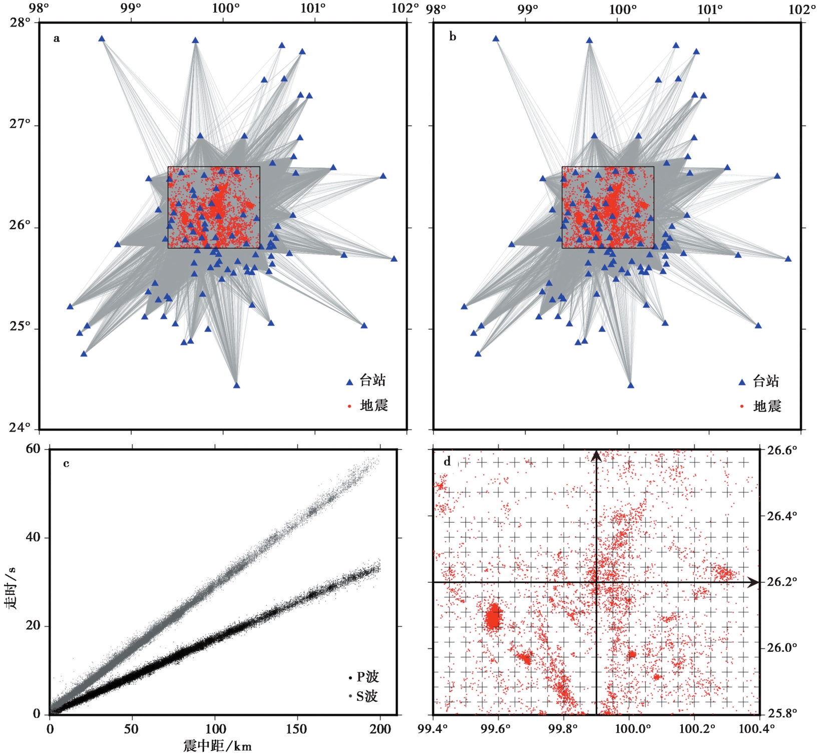
Fig. 2 Distribution of P-wave seismic ray paths(a), distribution of S-wave seismic ray paths(b), time-distance curves of P- and S-wave phases(c), distribution of the grid nodes(d).
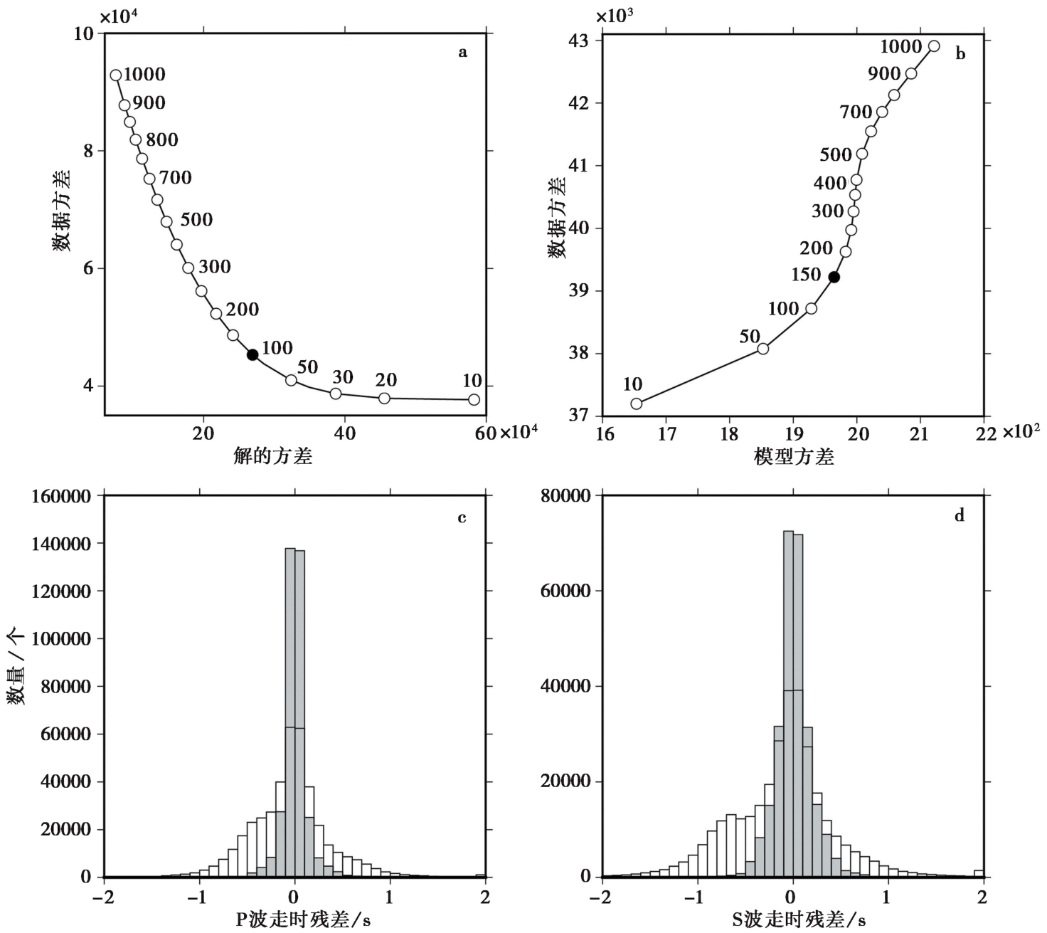
Fig. 3 Selection of smoothing factor(a)and optimal damping factor(b)and comparison of travel time residuals before(white histogram)and after(gray histogram)inversion for P-wave(c)and S-wave(d).
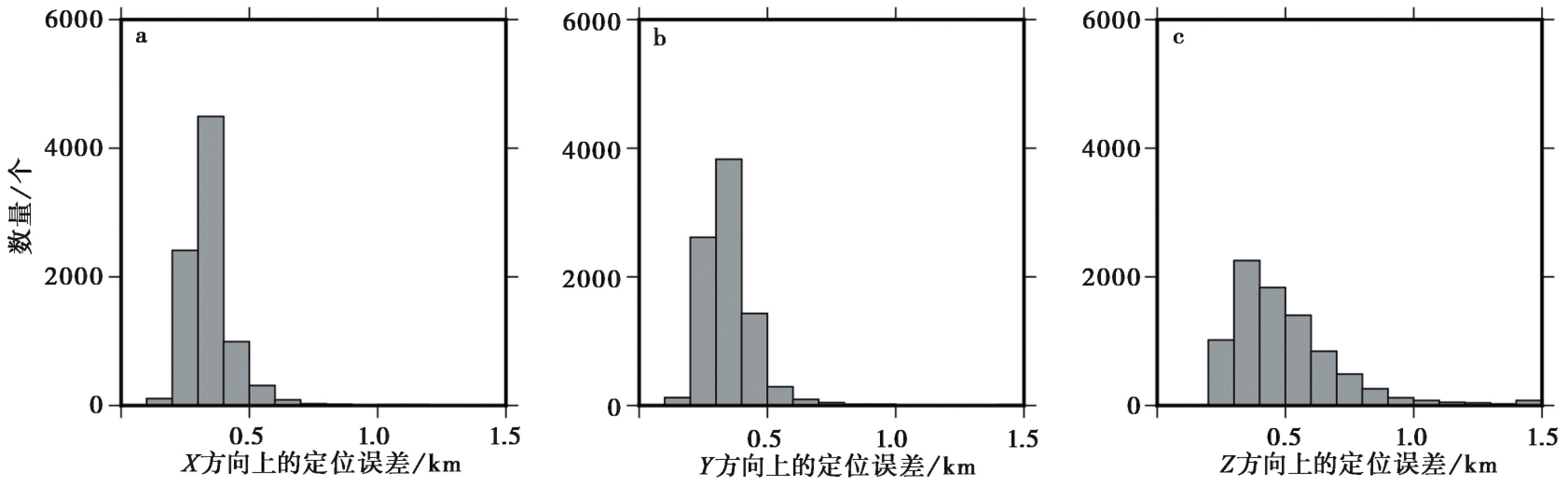
Fig. 4 Uncertainty histograms of earthquake relocations in the X (a), Y (b) and Z (c) directions.
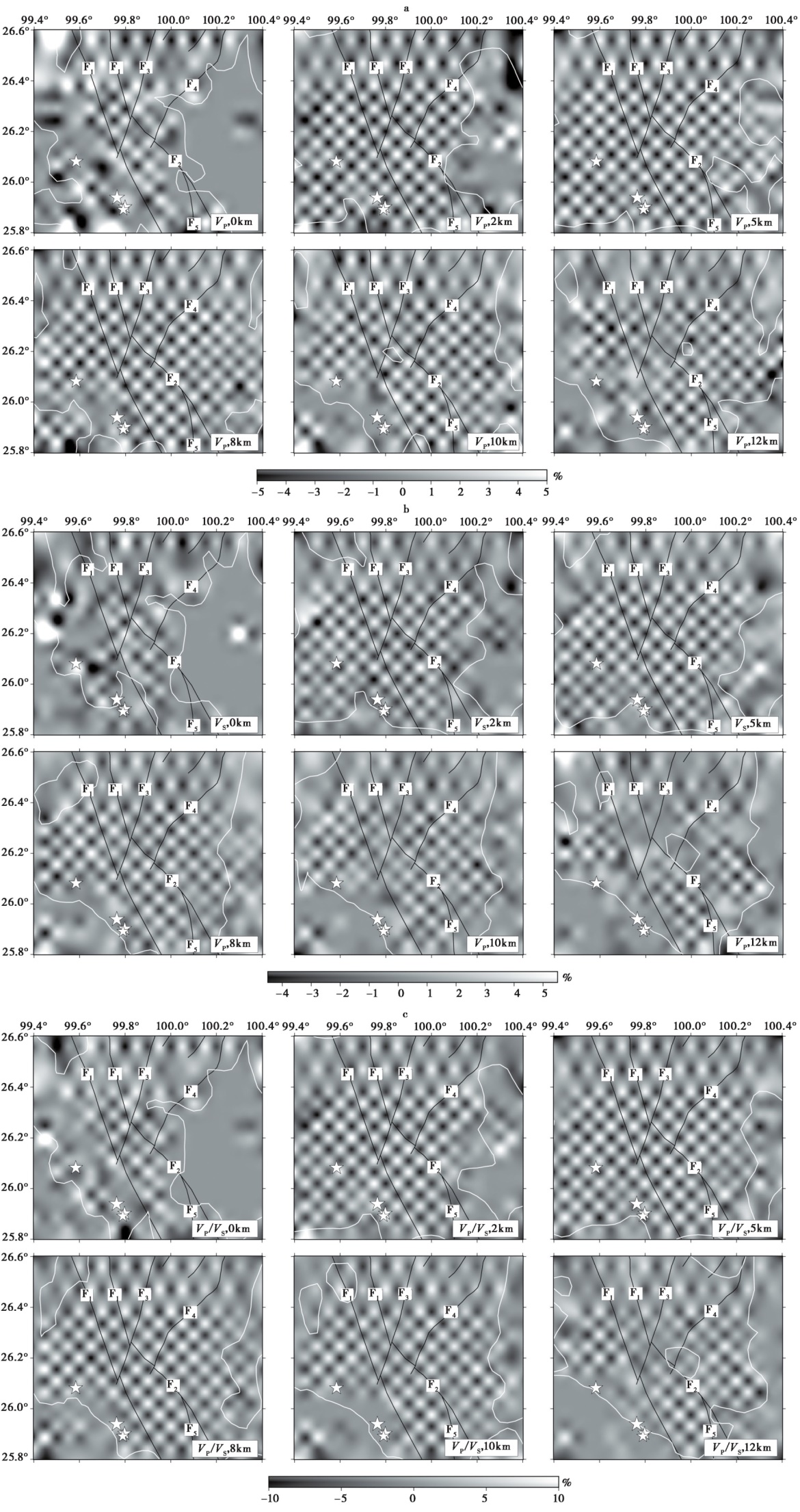
Fig. 5 Recovered results of the checkerboard test at various depths.
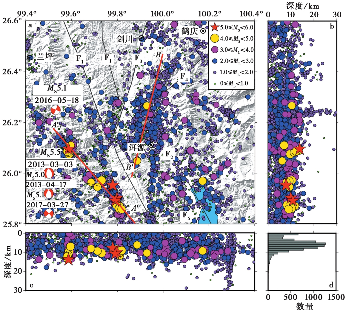
Fig. 6 Distribution of earthquake relocated events.
| 5级以上地震 | 本文重定位结果 | 其他研究的重定位结果 |
|---|---|---|
| 2013-03-03洱源MS5.5地震 | 25.952°N, 99.780°E, 7.9km | 25.952°N, 99.779°E, 7.5km(赵小艳等, |
| 2013-04-17洱源MS5.0地震 | 25.902°N, 99.798°E, 9.9km | 25.900°N, 99.800°E, 8.5km(赵小艳等, |
| 2016-05-18云龙MS5.1地震 | 26.095°N, 99.586°E, 13.8km | 无具体位置,深度约15km(李姣等, |
| 2017-03-27漾濞MS5.1地震 | 25.891°N, 99.790°E, 10.8km | 无具体位置,深度约15km(李姣等, |
Table1 A comparison of relocation results from this study and other’s
| 5级以上地震 | 本文重定位结果 | 其他研究的重定位结果 |
|---|---|---|
| 2013-03-03洱源MS5.5地震 | 25.952°N, 99.780°E, 7.9km | 25.952°N, 99.779°E, 7.5km(赵小艳等, |
| 2013-04-17洱源MS5.0地震 | 25.902°N, 99.798°E, 9.9km | 25.900°N, 99.800°E, 8.5km(赵小艳等, |
| 2016-05-18云龙MS5.1地震 | 26.095°N, 99.586°E, 13.8km | 无具体位置,深度约15km(李姣等, |
| 2017-03-27漾濞MS5.1地震 | 25.891°N, 99.790°E, 10.8km | 无具体位置,深度约15km(李姣等, |
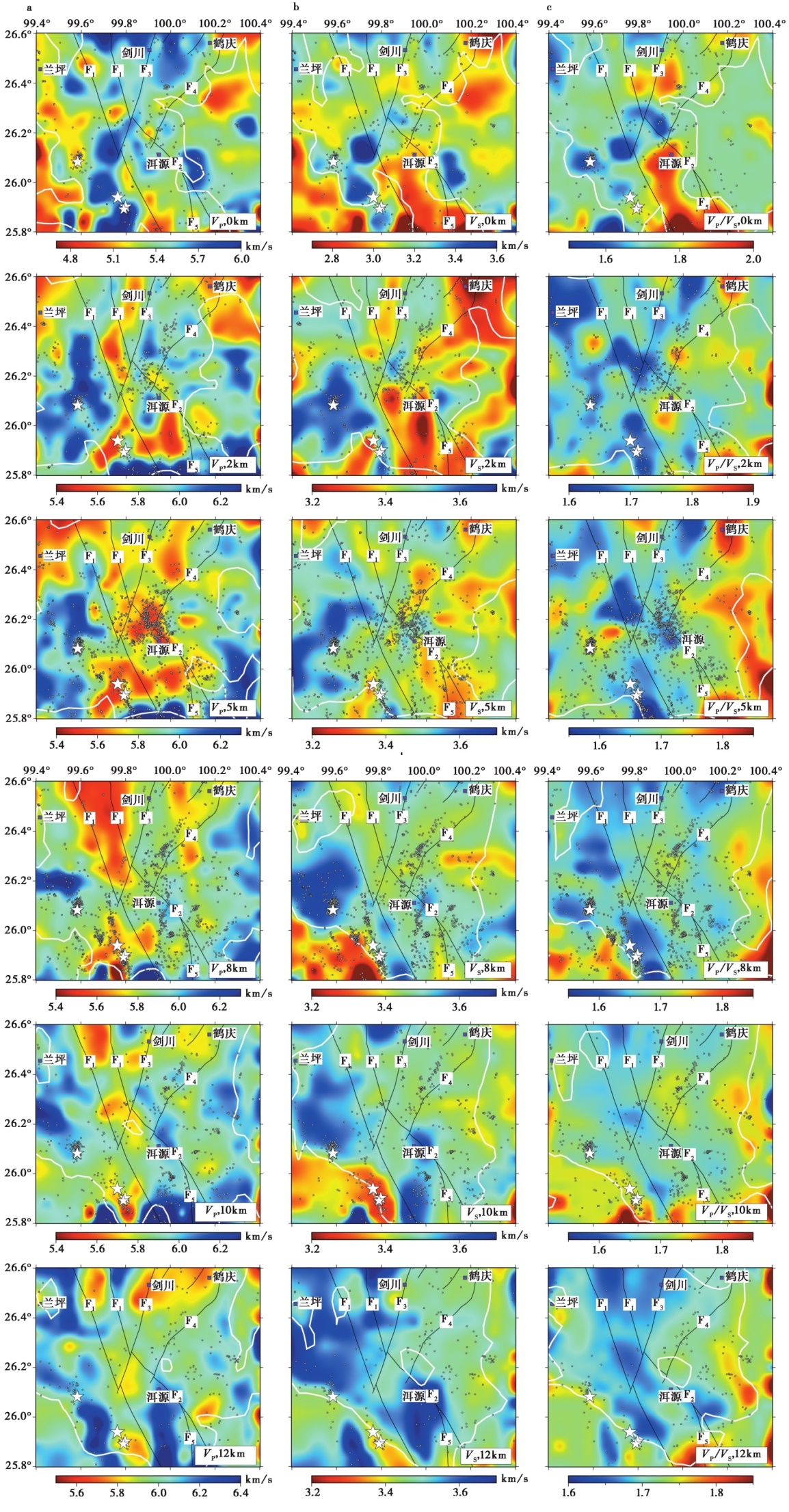
Fig. 7 Horizontal slices of the VP(a), VS(b)and VP/VS(c)images at various depths.
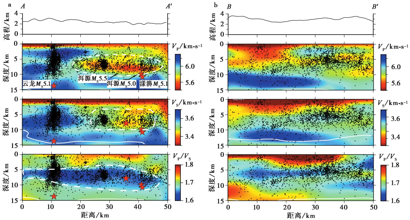
Fig. 8 The distribution of VP, VS and VP /VS on the vertical profile AA'(a)and BB'(b).
| [1] |
白志明, 王椿镛. 2003. 云南地区上部地壳结构和地震构造环境的层析成像研究[J]. 地震学报, 25(2): 117—127.
|
|
|
|
| [2] |
白志明, 王椿镛. 2004. 云南遮放—宾川和孟连—马龙宽角地震剖面的层析成像研究[J]. 地球物理学报, 47(2): 257—267.
|
|
|
|
| [3] |
常祖峰, 常昊, 李鉴林, 等. 2016a. 维西-乔后断裂南段正断层活动特征[J]. 地震研究, 39(4): 579—586.
|
|
|
|
| [4] |
常祖峰, 常昊, 李鉴林, 等. 2021. 维西-乔后断裂全新世活动与古地震[J]. 地震地质, 43(4): 881—898. doi: 10.3969/j.issn.0253-4967.2021.04.009.
|
|
DOI |
|
| [5] |
常祖峰, 常昊, 臧阳, 等. 2016b. 维西-乔后断裂新活动特征及其与红河断裂的关系[J]. 地质力学学报, 22(3): 517—530.
|
|
|
|
| [6] |
胡家富, 苏有锦, 朱雄关, 等. 2003. 云南的地壳S波速度与泊松比结构及其意义[J]. 中国科学(D辑), 33(8): 714—722.
|
|
|
|
| [7] |
黄小巾, 吴中海, 李家存, 等. 2014. 滇西北裂陷带的构造地貌特征与第四纪构造活动性[J]. 地质通报, 33(4): 578—593.
|
|
|
|
| [8] |
贾佳. 2020. 洱源地区地壳三维P波速度精细结构研究[D]. 北京: 中国地震局地球物理研究所:9—49.
|
|
|
|
| [9] |
阚荣举, 张四昌, 晏凤桐, 等. 1977. 我国西南地区现代构造应力场与现代构造活动特征的探讨[J]. 地球物理学报, 20(2): 96—109.
|
|
|
|
| [10] |
雷兴林, 王志伟, 马胜利, 等. 2021. 关于2021年5月滇西漾濞 MS6.4 地震序列特征及成因的初步研究[J]. 地震学报, 43(3): 261—286.
|
|
|
|
| [11] |
李姣, 姜金钟, 付虹. 2017. 2016年云南云龙 MS5.0 地震序列精定位研究[J]. 国际地震动态, (8): 35—36.
|
|
|
|
| [12] |
李姣, 姜金钟, 杨晶琼. 2020. 2017年漾濞 MS4.8 和 MS5.1 地震序列的微震检测及重定位[J]. 地震学报, 42(5): 527—542.
|
|
|
|
| [13] |
林元武. 1993. 红河断裂带北段温泉水循环深度与地震活动性的关系探讨[J]. 地震地质, 15(3): 193—206.
|
|
|
|
| [14] |
林元武. 1994a. 滇西地震带大理—剑川段中强地震迁移规律及其原因探讨[J]. 地震研究, 17(2): 136—142.
|
|
|
|
| [15] |
林元武. 1994b. 温泉热储温度对断裂的弱化作用及其对地震活动性的影响[J]. 地震学报, 16(2): 251—257.
|
|
DOI URL |
|
| [16] |
刘毅. 2020. 洱源地震震源区及周边精细速度结构和地震重定位研究[D]. 北京: 中国地质大学:10—43.
|
|
|
|
| [17] |
上官志冠. 1988. 滇西实验场区主要活动断裂地球化学特征[J]. 地震地质, 10(4): 134—141.
|
|
|
|
| [18] |
上官志冠, 高松井. 1987. 滇西实验场区温泉碳同位素地震地球化学特征[J]. 地震, (6): 25—35.
|
|
|
|
| [19] |
王博, 周永胜, 钟骏, 等. 2022. 滇西北构造地热特征及对地震活动的影响[J]. 地球物理学报, 65(9): 3419—3433.
|
|
|
|
| [20] |
王光明, 吴中海, 彭关灵, 等. 2021. 2021年5月21日漾濞 MS6.4 地震的发震断层及其破裂特征: 地震序列的重定位分析结果[J]. 地质力学学报, 27(4): 662—678.
|
|
|
|
| [21] |
王云, 冉华, 李其林, 等. 2019. 滇西北裂陷区地热及构造活动特征研究[J]. 矿物岩石地球化学通报, 38(5): 923—930.
|
|
|
|
| [22] |
徐锡伟, 闻学泽, 郑荣章, 等. 2003. 川滇地区活动块体最新构造样式及动力学来源[J]. 中国科学(D辑), 33(S1): 151—162.
|
|
|
|
| [23] |
颜鹍, 李如陶, 李四海. 1997. 滇西地震预报实验场区温泉地球化学与断裂活动的关系[J]. 大地构造与成矿学, 21(2): 129—136.
|
|
|
|
| [24] |
杨军, 苏有锦, 李孝宾, 等. 2015. 2013年洱源 MS5.5 地震序列ML≥3. 4地震的震源机制解研究[J]. 地震研究, 38(2): 196—202.
|
|
|
|
| [25] |
张培震, 王敏, 甘卫军, 等. 2003a. GPS观测的活动断裂滑动速率及其对现今大陆动力作用的制约[J]. 地学前缘, 10(S1): 81—92.
|
|
|
|
| [26] |
张培震, 邓起东, 张国民, 等. 2003b. 中国大陆的强震活动与活动地块[J]. 中国科学(D辑), 33(S1): 12—20.
|
|
|
|
| [27] |
赵小艳, 付虹. 2014. 2013年洱源 MS5.5 和 MS5.0 地震发震构造识别[J]. 地震学报, 36(4): 640—650.
|
|
|
|
| [28] |
DOI URL |
| [29] |
DOI URL |
| [30] |
DOI URL |
| [31] |
DOI URL |
| [32] |
|
| [33] |
DOI URL |
| [34] |
PMID |
| [35] |
DOI URL |
| [36] |
DOI |
| [37] |
|
| [38] |
DOI URL |
| [39] |
|
| [40] |
|
| [41] |
|
| [42] |
DOI URL |
| [43] |
DOI |
| [44] |
DOI URL |
| [45] |
DOI URL |
| [46] |
|
| [47] |
|
| [48] |
DOI URL |
| [49] |
DOI |
| [50] |
|
| [51] |
DOI URL |
| [52] |
DOI URL |
| [53] |
DOI URL |
| [54] |
|
| [55] |
PMID |
| [56] |
|
| [57] |
DOI URL |
| [1] | LUO Ren-yu, CHEN Ji-feng, YIN Xin-xin, LI Shao-hua. STUDY ON THE 3D CRUSTAL VELOCITY STRUCTURE OF BODY-WAVE IN GONGHE AREA [J]. SEISMOLOGY AND GEOLOGY, 2021, 43(1): 232-248. |
| [2] | ZHANG Na, ZHAO Cui-ping, LI Chun-hong, ZHOU Lian-qing. VELOCITY STRUCTURE TOMOGRAPHY OF REGIONS DOWNSTREAM THE JINSHA RIVER BASED ON DENSE OBSERVATION [J]. SEISMOLOGY AND GEOLOGY, 2019, 41(6): 1380-1394. |
| Viewed | ||||||
|
Full text |
|
|||||
|
Abstract |
|
|||||
