
SEISMOLOGY AND GEOLOGY ›› 2026, Vol. 48 ›› Issue (2): 582-596.DOI: 10.3969/j.issn.0253-4967.20240028
JOINT TOMOGRAPHY OF FIRST ARRIVAL AND REFLECTION WAVES AND ITS APPLICATION ON SUBSURFACE STRUCTURE DETECTION IN THE HUHHOT-BAOTOU BASIN
PAN Ji-shun1)( ), ZHANG Yun-tao1,2),*(), WANG Fu-yun2), FENG Shao-ying2), JI Ji-fa2), QI Hui1), TANG Yi-fan1), WANG Xin-yu1)
- 1)
North China University of Water Resources and Electric Power
2)Geophysical Exploration Center ,China Earthquake Administration
-
Received:2025-03-12Revised:2025-12-20Online:2026-04-20Published:2026-05-14
初至波与反射波联合层析成像及其在呼包盆地地下结构探测中的应用
潘纪顺1)(), 张允涛1,2),*(), 王夫运2), 酆少英2), 姬计法2), 戚慧1), 唐一帆1), 王鑫宇1)
- 1)
华北水利水电大学
2)中国地震局地球物理勘探中心
-
通讯作者:* 张允涛, 男, 1998年生, 硕士, 助理工程师, 主要从事活断层探测及地震层析成像研究, E-mail: zyt@gec.ac.cn。 -
作者简介:潘纪顺, 男, 1968年生, 教授, 主要从事地震层析成像与反演研究, E-mail: jsapn123@126.com。 -
基金资助:地球深部探测与矿产资源勘查国家科技重大专项(2024ZD1000100); 河南省自然科学基金(242300421461)
Cite this article
PAN Ji-shun, ZHANG Yun-tao, WANG Fu-yun, FENG Shao-ying, JI Ji-fa, QI Hui, TANG Yi-fan, WANG Xin-yu. JOINT TOMOGRAPHY OF FIRST ARRIVAL AND REFLECTION WAVES AND ITS APPLICATION ON SUBSURFACE STRUCTURE DETECTION IN THE HUHHOT-BAOTOU BASIN[J]. SEISMOLOGY AND GEOLOGY, 2026, 48(2): 582-596.
潘纪顺, 张允涛, 王夫运, 酆少英, 姬计法, 戚慧, 唐一帆, 王鑫宇. 初至波与反射波联合层析成像及其在呼包盆地地下结构探测中的应用[J]. 地震地质, 2026, 48(2): 582-596.
share this article
Add to citation manager EndNote|Ris|BibTeX
URL: https://www.dzdz.ac.cn/EN/10.3969/j.issn.0253-4967.20240028
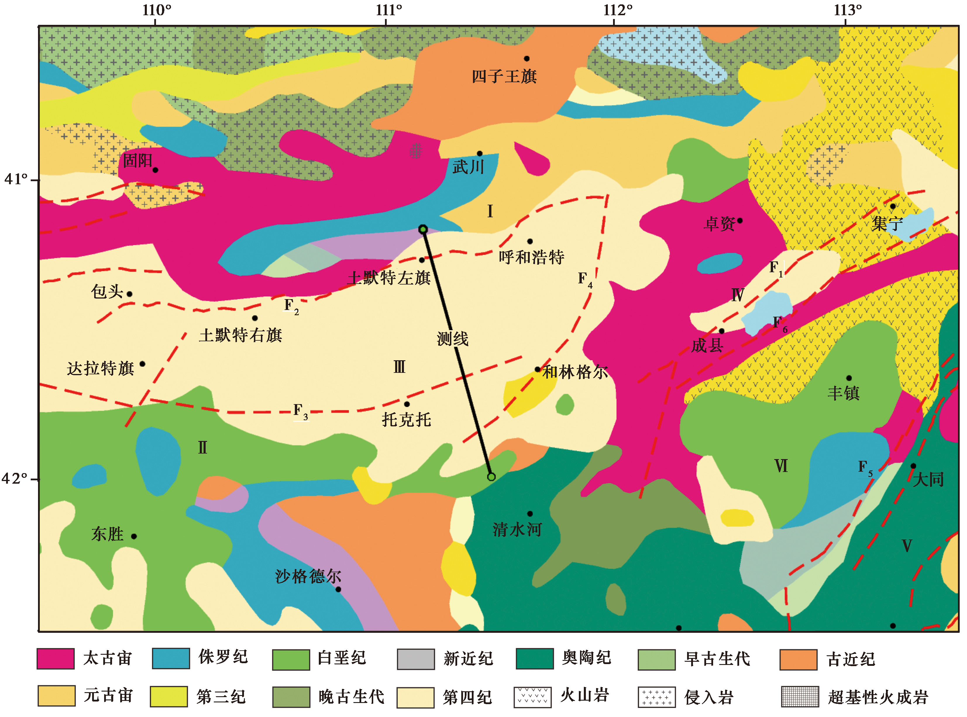
Fig. 1 Map of geological background and the seismic reflection profile of the study area (modified from FENG Shao-ying et al., 2015).
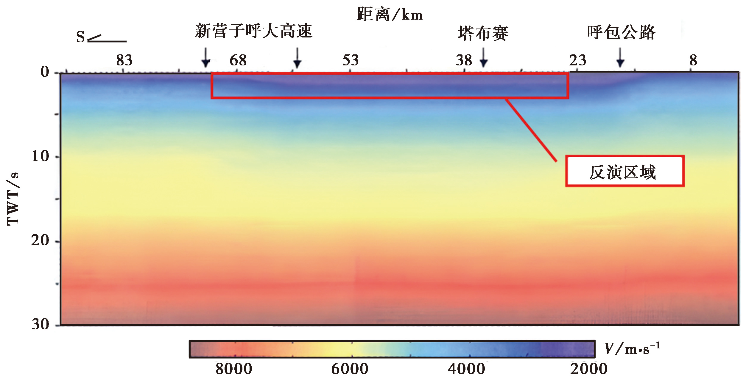
Fig. 2 Average velocity structure profile from deep seismic reflection(FENG Shao-ying et al., 2015).
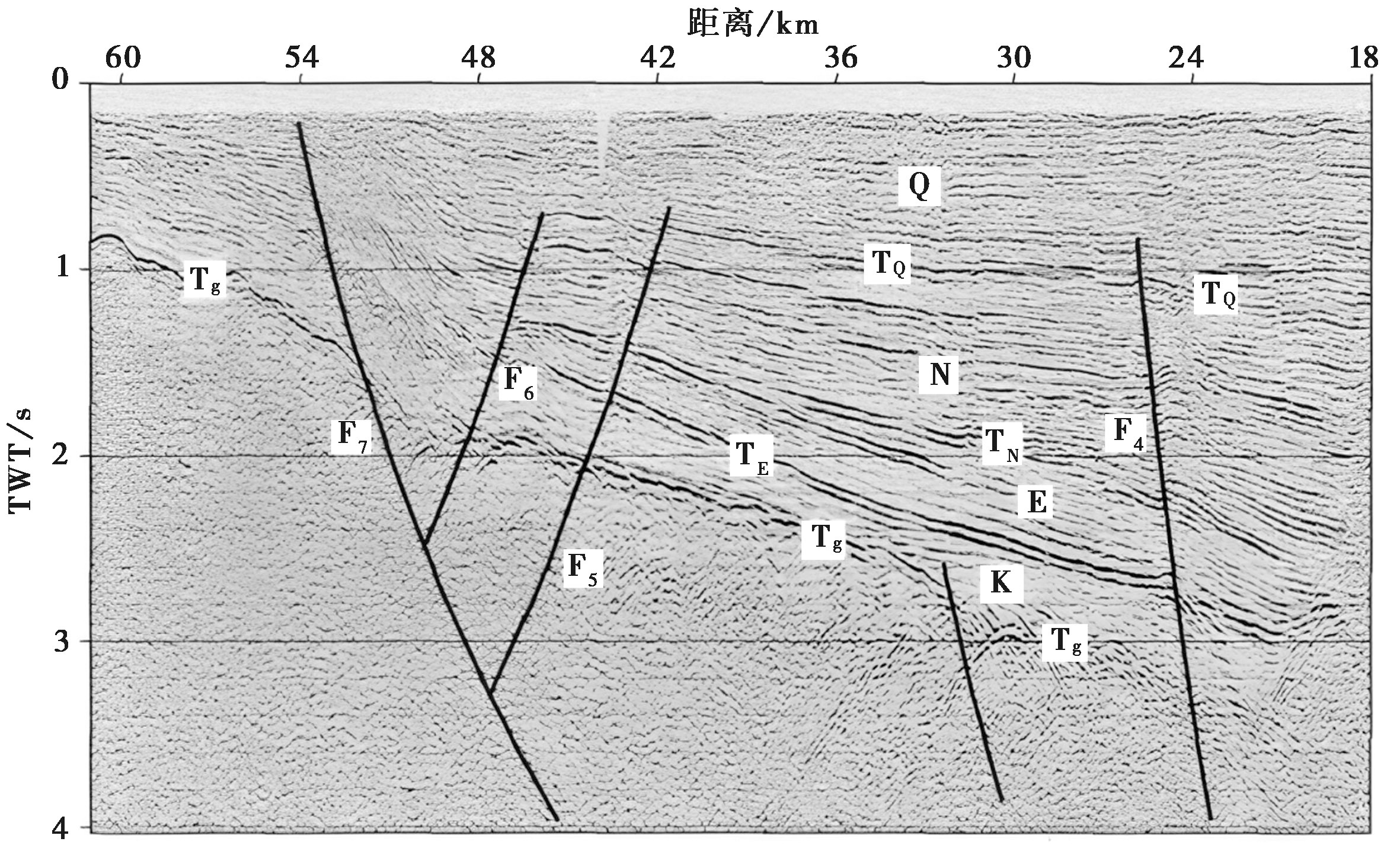
Fig. 3 Time profile of sedimentary layers by reflection exploration in the Huhhot-Baotou Basin (FENG Shao-ying et al., 2015).
| 地层 | 最浅部坐标 | 最深部坐标 | |||
|---|---|---|---|---|---|
| x/m | y/m | x/m | y/m | ||
| TQ | 48060 | 800 | 36720 | 1210 | |
| TN | 48060 | 1000 | 36720 | 2500 | |
| TE | 48060 | 1100 | 36720 | 2800 | |
| Tg | 48060 | 1200 | 36720 | 3300 | |
Table 1 Position information of reflection wave groups in the initial model
| 地层 | 最浅部坐标 | 最深部坐标 | |||
|---|---|---|---|---|---|
| x/m | y/m | x/m | y/m | ||
| TQ | 48060 | 800 | 36720 | 1210 | |
| TN | 48060 | 1000 | 36720 | 2500 | |
| TE | 48060 | 1100 | 36720 | 2800 | |
| Tg | 48060 | 1200 | 36720 | 3300 | |
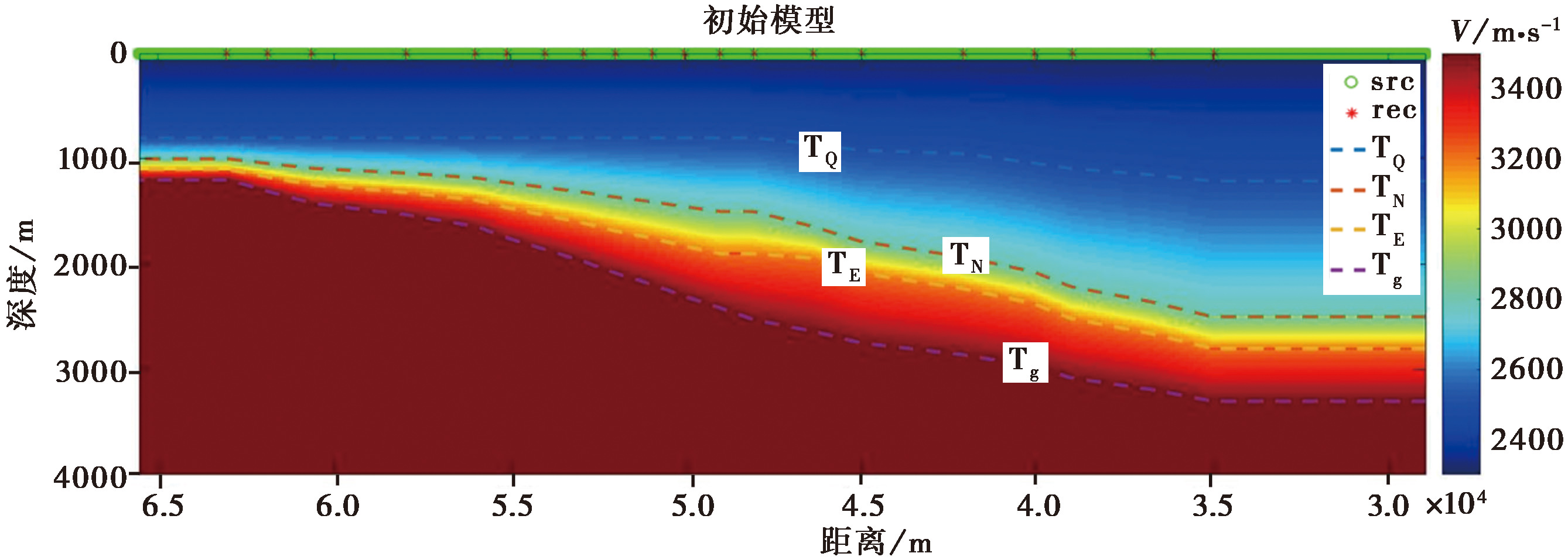
Fig. 4 Initial velocity model.
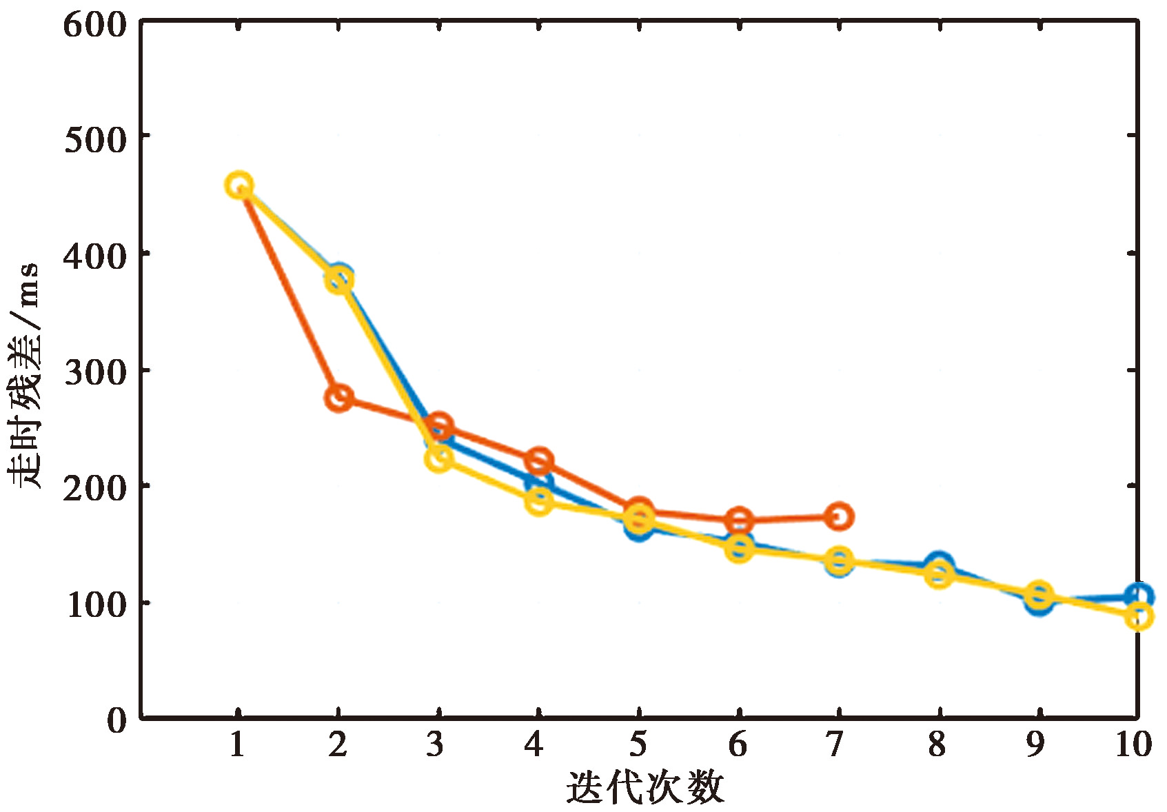
Fig. 5 Time residual variation during inversion process.
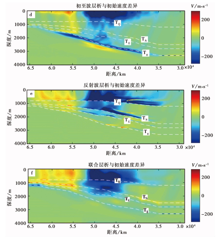
Fig. 6 Results from first arrival tomography, reflection tomography, and joint first arrival and reflection tomography respectively.
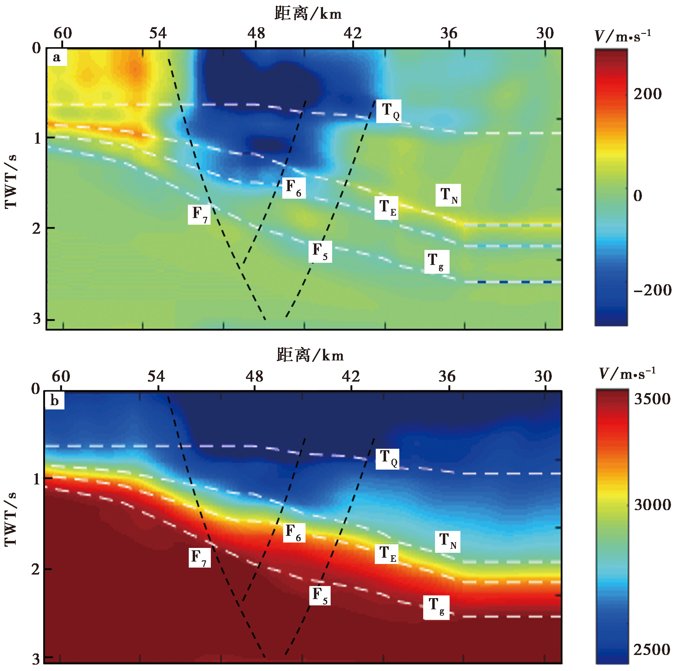
Fig. 7 Integrated stratigraphic profile with tomography results.
| [1] |
酆少英, 刘保金, 姬计法, 等. 2015. 呼和浩特—包头盆地岩石圈细结构的深地震反射探测[J]. 地球物理学报, 58(4): 1158—1168.
|
|
|
|
| [2] |
华标龙, 刘福田. 1995. 界面和速度反射联合成像——理论与方法[J]. 地球物理学报, 38(6): 750—756.
|
|
|
|
| [3] |
江娃利, 肖振敏, 王焕贞. 2000. 内蒙大青山山前活动断裂带西端左旋走滑现象[J]. 中国地震, 16(3): 203—212.
|
|
|
|
| [4] |
李庆春, 叶佩. 2013. 初至波与反射波旅行时多尺度渐进联合层析成像[J]. 石油地球物理勘探, 48(4): 536—544.
|
|
|
|
| [5] |
刘群. 2012. 内蒙古大青山山前断裂带构造变形特征[J]. 世界地质, 31(1): 113—119.
|
|
|
|
| [6] |
聂宗笙, 吴卫民, 马保起. 2010. 公元849年内蒙古包头东地震地表破裂带及地震参数讨论[J]. 地震学报, 32(1): 94—107.
|
|
|
|
| [7] |
石玉梅, 谢桂生. 1997. 联合反演速度和衰减的层析成像法[J]. 石油地球物理勘探, 32(S2): 51—56.
|
|
|
|
| [8] |
宋晓燕, 雷建设, 杜沫霏, 等. 2020. 鄂尔多斯地块北部及邻区Pn波速度结构与各向异性[J]. 地震学报, 42(3): 256—268.
|
|
|
|
| [9] |
滕吉文, 王夫运, 赵文智, 等. 2008. 鄂尔多斯盆地上地壳速度分布与沉积建造和结晶基底起伏的构造研究[J]. 地球物理学报, 51(6): 1753—1766.
|
|
|
|
| [10] |
滕吉文, 王夫运, 赵文智, 等. 2010. 阴山造山带—鄂尔多斯盆地岩石圈层、 块速度结构与深层动力过程[J]. 地球物理学报, 53(1): 67—85.
|
|
|
|
| [11] |
王谦身, 滕吉文, 王光杰, 等. 2005. 内蒙古阴山地区特异区域重磁场与深部构造[J]. 地球物理学报, 48(2): 314—320.
|
|
|
|
| [12] |
王涛, 徐鸣洁, 王良书, 等. 2007. 鄂尔多斯及邻区航磁异常特征及其大地构造意义[J]. 地球物理学报, 50(1): 163—170.
|
|
|
|
| [13] |
王运生, 苏建黎. 2007. 浅层地震联合成像技术及其应用研究[J]. 工程地球物理学报, 4(4): 306—311.
|
|
|
|
| [14] |
张兵, 王华忠. 2019. 数据域初至波走时与成像域反射波走时联合层析速度建模方法[J]. 地球物理学报, 62(7): 2633—2644.
|
|
|
|
| [15] |
张洪双, 田小波, 刘芳, 等. 2009. 呼包盆地周缘壳、 幔结构研究[J]. 地球物理学进展, 24(5): 1609—1615.
|
|
|
|
| [16] |
郑亚东,
|
|
|
|
| [17] |
|
| [18] |
|
| [19] |
|
| [20] |
|
| [21] |
|
| [22] |
|
| [23] |
|
| [24] |
|
| [25] |
|
| [26] |
|
| [27] |
|
| [28] |
|
| [29] |
|
| [30] |
|
| [31] |
|
| [32] |
|
| [33] |
|
| [34] |
|
| [35] |
|
| [36] |
|
| [37] |
|
| [38] |
|
| [39] |
|
| [40] |
|
| No related articles found! |
| Viewed | ||||||
|
Full text |
|
|||||
|
Abstract |
|
|||||
Copyright © SEISMOLOGY AND GEOLOGY, All Rights Reserved.
Tel: 010-62009049/9063 E-mail: dzdz@ies.ac.cn
Powered by Beijing Magtech Co., Ltd.