
SEISMOLOGY AND GEOLOGY ›› 2025, Vol. 47 ›› Issue (3): 932-948.DOI: 10.3969/j.issn.0253-4967.2025.03.20250019
Previous Articles Next Articles
COMPARATIVE STUDY ON BUILDING DAMAGE CAUSED BY THE 2025 MS6.8 EARTHQUAKE IN DINGRI, XIZANG, BASED ON REMOTE SENSING AND SEISMIC SIMULATION
YUAN Xiao-xiang1,2)( ), LIN Xu-chuan1),*(), CHEN Zi-feng1), ZHANG Jian-long3), DOU Ai-xia2), XIAO Ben-fu4), DU Hao-guo5), YU Si-han6), DING Xiang2), FANG Jie1,7), WANG Shu-min2)
- 1)Key Laboratory of Earthquake Disaster Mitigation,Institute of Engineering Mechanics, China Earthquake Administration, Ministry of Emergency Management, Key Laboratory of Earthquake Engineering and Engineering Vibration, Harbin 150080, China
2)Key Laboratory of Earthquake Prediction and Risk Assessment Emergency Management Department, Institute of Earthquake Forecasting, China Earthquake Administration, Beijing 100036, China
3)Earthquake Agency of Xizang Autonomous Region, Lhsa 850000, China
4)Sichuan Earthquake Agency, Chengdu 610041, China
5)Yunnan Earthquake Agency, Kunming 650224, China
6)Earthquake Agency of Ningxia Hui Autonomous Region, Yingchuan 750001, China
7)Wuhan Institute of Earthquake Engineering Co., Ltd., Institute of Seismology, China Earthquake Administration, Wuhan 430060, China
-
Received:2025-01-24Revised:2025-03-20Online:2025-06-20Published:2025-08-13
基于遥感和震害仿真的2025年西藏定日6.8级地震建筑物震害对比
袁小祥1,2)(), 林旭川1),*(), 陈子峰1), 张建龙3), 窦爱霞2), 肖本夫4), 杜浩国5), 余思汗6), 丁香2), 方杰1,7), 王书民2)
- 1)中国地震局工程力学研究所, 地震灾害防治应急管理部重点实验室, 中国地震局地震工程 与工程振动重点实验室, 哈尔滨 150080
2)中国地震局地震预测研究所, 地震预测与风险评估应急管理部重点实验室, 北京 100036
3)西藏自治区地震局, 拉萨 850000
4)四川省地震局, 成都 610041
5)云南地震局, 昆明 650224
6)宁夏回族自治区地震局, 银川 750001
7)中国地震局地震研究所, 武汉地震工程研究院有限公司, 武汉 430060
-
通讯作者:*林旭川, 男, 1984年生, 研究员, 主要从事结构工程抗震、 区域地震灾害模拟等领域研究, E-mail: linxuchuan@iem.ac.cn。 -
作者简介:袁小祥, 男, 1983年生, 现为中国地震局工程力学研究所结构工程方向在读博士研究生, 副研究员, 主要从事基于多源空间信息的地震灾害信息提取、 震害仿真与地震灾害风险评估等研究, E-mail: yuanxx@ief.ac.cn。
-
基金资助:宁夏重点研发计划重点项目(2024BEG02033); 国家自然科学基金(42271090); 应急管理部重点科技计划项目(2024EMST050503); 中国地震局地震预测研究所地震业务科技支撑项目(CEAIEF20240508)
Cite this article
YUAN Xiao-xiang, LIN Xu-chuan, CHEN Zi-feng, ZHANG Jian-long, DOU Ai-xia, XIAO Ben-fu, DU Hao-guo, YU Si-han, DING Xiang, FANG Jie, WANG Shu-min. COMPARATIVE STUDY ON BUILDING DAMAGE CAUSED BY THE 2025 MS6.8 EARTHQUAKE IN DINGRI, XIZANG, BASED ON REMOTE SENSING AND SEISMIC SIMULATION[J]. SEISMOLOGY AND GEOLOGY, 2025, 47(3): 932-948.
袁小祥, 林旭川, 陈子峰, 张建龙, 窦爱霞, 肖本夫, 杜浩国, 余思汗, 丁香, 方杰, 王书民. 基于遥感和震害仿真的2025年西藏定日6.8级地震建筑物震害对比[J]. 地震地质, 2025, 47(3): 932-948.
share this article
Add to citation manager EndNote|Ris|BibTeX
URL: https://www.dzdz.ac.cn/EN/10.3969/j.issn.0253-4967.2025.03.20250019
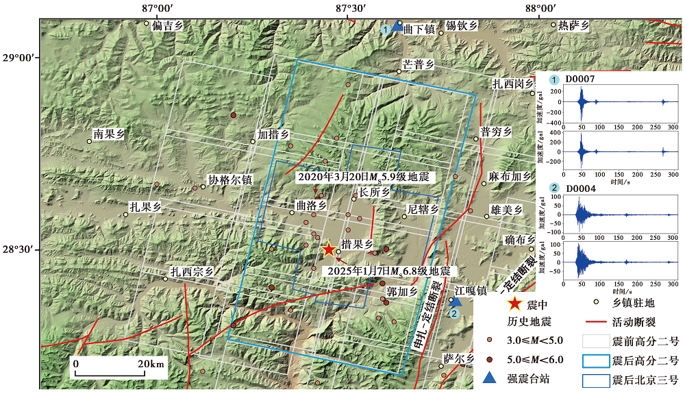
Fig. 1 Overview map of the study area in the Dingri MS6.8 earthquake.
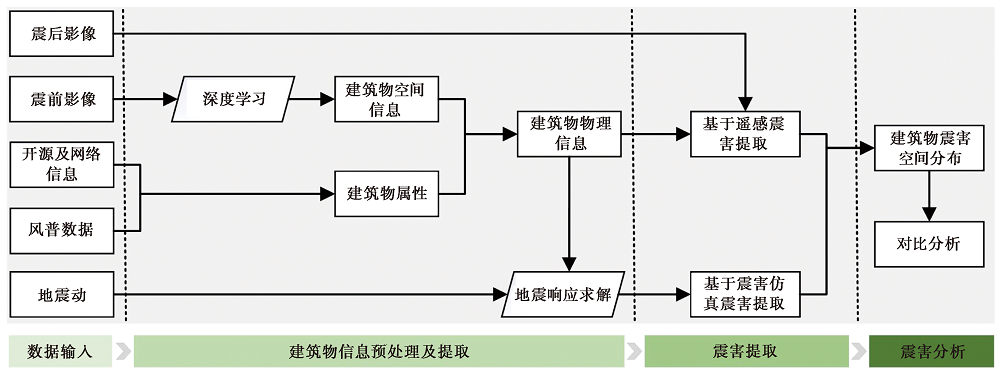
Fig. 2 Workflow of seismic damage extraction based on remote sensing and seismic hazard simulation.
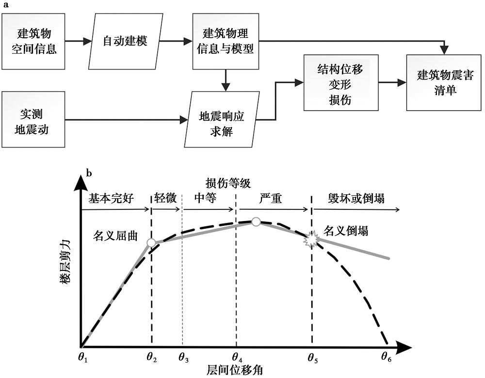
Fig. 3 Building seismic damage simulation methods(adapted from LIN Xu-chuan, 2017; Lin et al., 2024).
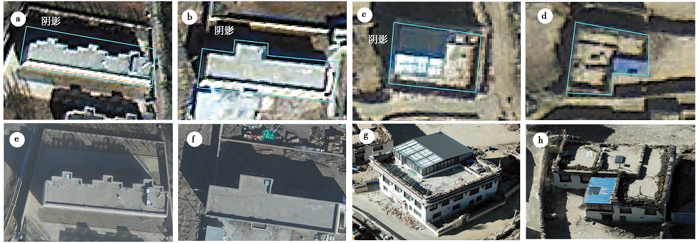
Fig. 4 Visualization of seismic damage interpretation indicators based on remote sensing images.
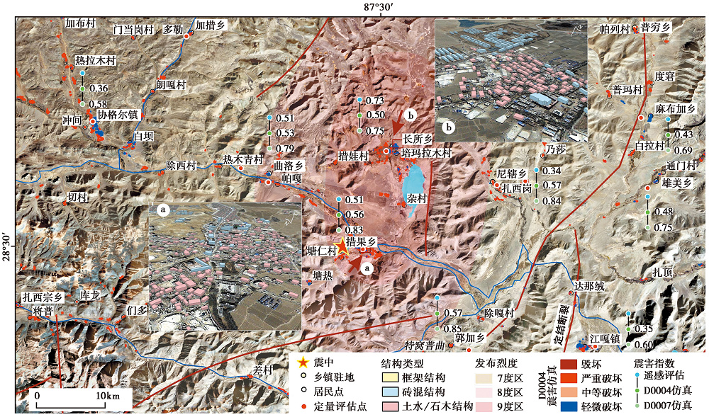
Fig. 5 Distribution of visualized earthquake damage extraction results for typical scenarios in the study area.
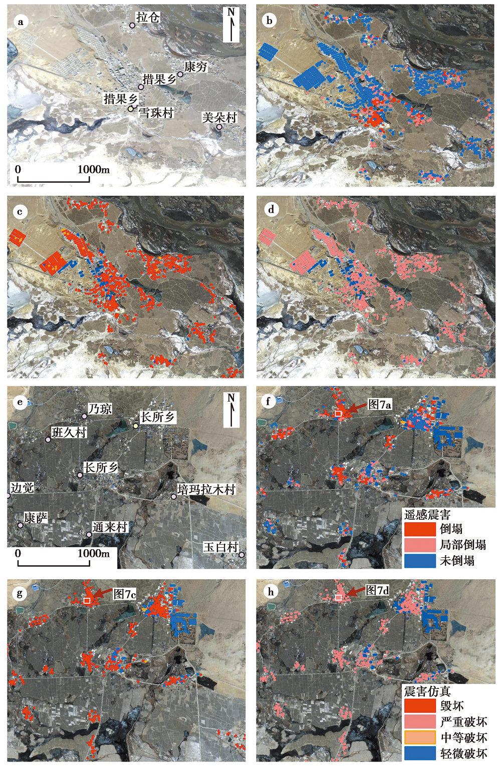
Fig. 6 Local seismic building damages in the severely affected area.

Fig. 7 Comparative analysis of seismic building damage in representative local areas of Changsuo Town.
| 震害类别 | 震害仿真(D0004/D0007) | ||||
|---|---|---|---|---|---|
| 遥感 | 毁坏 | 严重破坏 | 中等破坏 | 轻微破坏 | 基本完好 |
| 倒塌 | 0.0/11.9 | 11.9/0.0 | 0.0/0.0 | 0.1/0.1 | 0.0/0.0 |
| 局部倒塌 | 0.0/17.9 | 17.9/0.0 | 0.0/0.1 | 0.3/0.2 | 0.0/0.0 |
| 未倒塌 | 0.0/66.7 | 66.7/0.1 | 0.0/1.4 | 1.9/1.7 | 1.2/0.0 |
Table 1 Result comparison between rapid remote sensing seismic damage identification and seismic damage simulation in percentage
| 震害类别 | 震害仿真(D0004/D0007) | ||||
|---|---|---|---|---|---|
| 遥感 | 毁坏 | 严重破坏 | 中等破坏 | 轻微破坏 | 基本完好 |
| 倒塌 | 0.0/11.9 | 11.9/0.0 | 0.0/0.0 | 0.1/0.1 | 0.0/0.0 |
| 局部倒塌 | 0.0/17.9 | 17.9/0.0 | 0.0/0.1 | 0.3/0.2 | 0.0/0.0 |
| 未倒塌 | 0.0/66.7 | 66.7/0.1 | 0.0/1.4 | 1.9/1.7 | 1.2/0.0 |
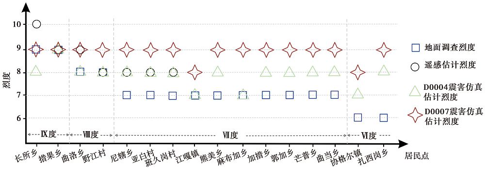
Fig. 8 Comparison of quantitative assessment results of seismic damage to typical residential buildings.
| 评估烈度 | 遥感评估结果 | D0004仿真结果 | D0007仿真结果 | |||||||
|---|---|---|---|---|---|---|---|---|---|---|
| Ⅹ度 | Ⅸ度 | Ⅷ度 | Ⅸ度 | Ⅷ度 | Ⅶ度 | Ⅸ度 | Ⅷ度 | Ⅶ度 | ||
| 居民点对应 发布烈度 | Ⅸ度 | 1 | 1 | 1 | 1 | 2 | ||||
| Ⅷ度 | 1 | 1 | 2 | 2 | ||||||
| Ⅶ度 | 3 | 8 | 2 | 9 | 1 | |||||
| Ⅵ度 | 1 | 1 | 1 | 1 | ||||||
Table2 Comparative analysis between assessed intensity from different methods and official released intensity in residential settlements
| 评估烈度 | 遥感评估结果 | D0004仿真结果 | D0007仿真结果 | |||||||
|---|---|---|---|---|---|---|---|---|---|---|
| Ⅹ度 | Ⅸ度 | Ⅷ度 | Ⅸ度 | Ⅷ度 | Ⅶ度 | Ⅸ度 | Ⅷ度 | Ⅶ度 | ||
| 居民点对应 发布烈度 | Ⅸ度 | 1 | 1 | 1 | 1 | 2 | ||||
| Ⅷ度 | 1 | 1 | 2 | 2 | ||||||
| Ⅶ度 | 3 | 8 | 2 | 9 | 1 | |||||
| Ⅵ度 | 1 | 1 | 1 | 1 | ||||||
| [1] |
国家市场监督管理总局, 国家标准化管理委员会. 2020. 中国地震烈度表(GB/T 17742-2020)[S]. 北京: 中国标准出版社.
|
|
State Administration for Market Regulation, Inspection and Quarantine of the People’s Republic of China, Standards Administration of China. 2020. The Chinese seismic intensity scale(GB/T 17742-2020)[S]. China Standards Press, Beijing (in Chinese).
|
|
| [2] |
林旭川. 2017. 城市建筑群地震灾害数值仿真与风险控制[J]. 城市与减灾, 20(3): 18-22.
|
|
|
|
| [3] |
陆新征, 田源, 许镇, 等. 2020. 一种新型城市地震灾害模拟方法: 城市抗震弹塑性分析方法[J]. 科学通报, 65(11): 1055-1062.
|
|
|
|
| [4] | |
|
DOI |
|
| [5] |
潘毅, 张兰林, 林旭川, 等. 2024. 泸县6.0级地震城市建筑群震害模拟与震害机理分析[J]. 防灾减灾工程学报, 44(5): 977-986.
|
|
|
|
| [6] |
孙柏涛, 张桂欣. 2017. 中国大陆建筑物地震灾害风险分布研究[J]. 土木工程学报, 50(9): 1-7.
|
|
|
|
| [7] |
王晓青, 窦爱霞, 丁香, 等. 2015a. 地震烈度应急遥感评估研究与应用进展[J]. 地球信息科学, 17(12): 1536-1543.
|
|
|
|
| [8] |
王晓青, 窦爱霞, 王龙, 等. 2015b. 2013年四川芦山7.0级地震烈度遥感评估[J]. 地球物理学报, 58(1): 163-171.
|
|
|
|
| [9] |
王晓青, 王龙, 章熙海, 等. 2009. 汶川8.0级地震震害遥感定量化初步研究——以都江堰城区破坏为例[J]. 地震, 29(1): 174-181.
|
|
|
|
| [10] |
王晓青. 2010. 汶川地震建筑物震害遥感解译图集[M]. 北京: 地震出版社: 82-91.
|
|
|
|
| [11] |
温瑞智, 贾国玉. 1998. 城市建筑物震害损失快速评估系统[J]. 世界地震工程, 14(2): 23-28.
|
|
|
|
| [12] |
吴开来. 2018. 城市震害模拟中带填充墙RC框架结构模型参数取值方法研究[D]. 哈尔滨: 中国地震局工程力学研究所.
|
|
|
|
| [13] |
肖本夫, 袁小祥, 陈波, 等. 2023. 基于倾斜摄影技术的典型情景可视化震害定量评估——以四川马尔康震群为例[J]. 地震地质, 45(4): 847-863. doi: 10.3969/j.issn.0253-4967.2023.04.003.
|
|
DOI |
|
| [14] |
徐心悦. 2019. 藏南申扎-定结断裂系卡达正断裂晚第四纪活动性及其环境效应[D]. 北京: 中国地震局地质研究所.
|
|
|
|
| [15] |
袁小祥, 林旭川, 窦爱霞, 等. 2023. 基于震前高分影像和震害仿真的建筑物震害快速评估: 以四川泸定6.8级地震为例[J]. 地球物理学报, 66(4): 1438-1447.
|
|
|
|
| [16] |
袁小祥, 王晓青, 丁香, 等. 2017. 基于无人机影像的九寨沟地震建筑物震害定量评估[J]. 中国地震, 33(4): 582-589.
|
|
|
|
| [17] |
张彪. 2022. 材料不确定性对RC框架结构抗震性能及城市震害模拟结果的影响[D]. 成都: 西南交通大学.
|
|
|
|
| [18] |
张建龙, 尼玛, 司金罗布, 等. 2021. 西藏定日 MS5.9 地震烈度评定及震害特征分析[J]. 西藏科技, 334:48-49, 59.
|
|
|
|
| [19] |
张进江, 郭磊, 丁林, 等. 2002. 申扎-定结正断层体系中、南段构造特征及其与藏南拆离系的关系[J]. 科学通报, 47(10): 738-743.
|
|
|
|
| [20] |
张景发, 李强, 张庆云, 等. 2018. 多源遥感图像的1976年 MS7.8 唐山大地震等烈度区判定[J]. 遥感学报, 22(S1): 162-173.
|
|
|
|
| [21] |
中国地震局. 2018a. 地震灾害遥感评估建筑物破坏(DB/T 75-2018)[S]. 北京: 中国标准出版社.
|
|
China Earthquake Administration. 2018a. Remote sensing assessment of earthquake disasters and building damage(GB/T 75-2018)[S]. China Standards Press, Beijing (in Chinese).
|
|
| [22] |
中国地震局. 2018b. 地震灾害遥感评估地震烈度(DB/T 77-2018)[S]. 北京: 中国标准出版社.
|
|
China Earthquake Administration. 2018b. Remote sensing assessment of earthquake disasters and seismic intensity(GB/T 77-2018)[S]. China Standards Press, Beijing (in Chinese).
|
|
| [23] |
中国地震局地质研究所. 2025. 2025年西藏定日6.8级地震地壳形变及发震断裂模型初步分析. [EB/OL]. [2025-01-09]. https://www.eq-igl.ac.cnzhxwinfo/2025/38560.html
|
|
Institute of Geology, China Earthquake Administration. 2025. Preliminary analysis of crustal deformation and seismogenic fault model of the 2025 Xizang Dingri M6.8 earthquake. [EB/OL]. [2025-01-09]. https://www.eq-igl.ac.cnzhxwinfo/2025/38560.html in Chinese)
|
|
| [24] |
|
| [25] |
|
| [26] |
|
| [27] |
|
| [28] |
|
| [29] |
|
| [30] |
|
| [31] |
|
| [32] |
|
| [33] |
|
| [34] |
|
| [35] |
|
| [36] |
|
| [37] |
|
| [38] |
|
| [39] |
|
| [40] |
|
| [41] |
|
| [42] |
|
| [43] |
|
| [1] | GUO Xin-xin, WEI Ben-yong, SU Gui-wu, QI Wen-hua, ZHANG Teng-fei. ASSESSING SEVERELY AFFECTED AREAS BY EARTHQUAKE USING MOBILE SIGNALLING DATA: A CASE STUDY OF THE 2023 MS6.2 JISHISHAN EARTHQUAKE, CHINA [J]. SEISMOLOGY AND GEOLOGY, 2026, 48(2): 520-539. |
| [2] | YANG Jiu-yuan, WEN Yang-mao, XU Cai-jun, YANG Jian-bing. SEISMOGENIC STRUCTURE OF THE DINGRI MW5.7 EARTH-QUAKE OF MARCH 20, 2020 (SOUTHERN QINGHAI-XIZANG PLATEAU) CONSTRAINED BY THE COSEISMIC AND POSTSEISMIC DEFORMATION [J]. SEISMOLOGY AND GEOLOGY, 2025, 47(4): 1292-1305. |
| [3] | WANG Peng, DAI Zong-hui, KONG Xue, LI Bo, XU Chang-peng, ZHANG Meng-xin. ANALYSIS ON THE EVOLUTION CHARACTERISTICS OF LOCAL STRESS FIELD IN THE MAGNITUDE 6.8 EARTHQUAKE SEQUENCE IN DINGRI, XIZANG [J]. SEISMOLOGY AND GEOLOGY, 2025, 47(3): 881-896. |
| [4] | YIN Xin-xin, ZUO Ke-zhen, ZHAO Cui-ping, CAI Run. RELOCATION AND FORESHOCK SEQUENCE IDENTIFICATION OF DINGRI MS6.8 EARTHQUAKE IN XIZANG [J]. SEISMOLOGY AND GEOLOGY, 2025, 47(3): 850-868. |
| [5] | ZHANG Sheng-feng, ZHANG Yong-xian. AFTERSHOCK PROBABILISTIC FORECASTING AND TESTING OF OPERABILITY IN EARTHQUAKE FIELD INVESTIGATION ON-SITE: A CASE OF THE 2025 DINGRI MS6.8 EARTHQUAKE IN XIZANG [J]. SEISMOLOGY AND GEOLOGY, 2025, 47(3): 835-849. |
| [6] | WAN Yong-ge, WANG Run-yan, JIN Zhi-tong, LAN Cong-xin. SOURCE CHARACTERISTICS OF THE 2025 DINGRI EARTHQUAKE AND ITS IMPLICATIONS FOR THE ACTIVITY OF THE SHENZHA-DINGJIE RIFT ZONE [J]. SEISMOLOGY AND GEOLOGY, 2025, 47(3): 806-819. |
| [7] | LIU Sheng, TAN Hong-bo, YANG Guang-liang, MENG Heng-zhou, QIN Hai-tao, WANG Jia-pei, HUANG Min-fu. INVERSION OF THE RUPTURE PROCESS OF THE XIZANG DINGRI MW7.1 EARTHQUAKE IN 2025 [J]. SEISMOLOGY AND GEOLOGY, 2025, 47(3): 777-788. |
| [8] | MENG Heng-zhou, YANG Guang-liang, QIN Hai-tao, TAN Hong-bo, LIU Sheng, WANG Jia-pei, HUANG Min-fu, ZHANG Ming-hui. HORIZONTAL DEVIATORIC STRESS AND ELASTIC LITHOSPHERE THICKNESS CHARACTERISTICS OF THE EPICENTER AND ITS ADJACENT AREAS OF THE DINGRI MS6.8 EARTHQUAKE, XIZANG, CHINA [J]. SEISMOLOGY AND GEOLOGY, 2025, 47(3): 761-776. |
| [9] | CHEN Han-lin, WANG Qin-cai, GAO Jin-rui, LI Jun. PRELIMINARY STUDY ON THE SEISMOGENIC STRUCTURE OF THE 2025 XIZANG DINGRI MS6.8 EARTHQUAKE SEQUENCE [J]. SEISMOLOGY AND GEOLOGY, 2025, 47(3): 747-760. |
| [10] | ZHANG Da, SHI Feng, LUO Quan-xing, QIAO Jun-xiang, WANG xin, YI Wen-xing, LI Tao, LI an. THE MAXIMUM VERTICAL DISPLACEMENT OF THE MS6.8 EARTHQUAKE IN XIZANG AND ITS SURFACE DEFORMATION STYLE [J]. SEISMOLOGY AND GEOLOGY, 2025, 47(3): 707-717. |
| [11] | SHENG Shu-zhong, WANG Qian-ru, LI Zhen-yue, LI Hong-xing, ZHANG Xiao-juan, GE Kun-peng, GONG Meng. INVESTIGATION OF THE SEISMOGENIC STRUCTURE OF THE 2025 DINGRI MS6.8 EARTHQUAKE IN XIZANG BASED ON THE TECTONIC STRESS FIELD PERSPECTIVE [J]. SEISMOLOGY AND GEOLOGY, 2025, 47(1): 49-63. |
| [12] | BAI Qilegeer, SHEN Jun, XIAO Chun, DAI Xun-ye. TYPICAL REMOTE SENSING IMAGES OF HOLOCENE FAULTS IN GAIZE PAN(I45)IN TIBET [J]. SEISMOLOGY AND GEOLOGY, 2023, 45(1): 92-110. |
| [13] | AN Ji-wen, XU Jing-hai, NIE Gao-zhong, BAI Xian-fu. earthquake disaster rapid assessment for emergency response supported by high-precision data of hazard bearing body [J]. SEISMOLOGY AND GEOLOGY, 2015, 37(4): 1225-1241. |
| [14] | GUO Jian-ming, FU Bi-hong, LIN Ai-ming, Ken-ichi Kano, Tadashi Maruyama. CHARACTERISTICS OF THE REMOTE SENSING IMAGES OF ACTIVE TECTONICS IN YANQI BASIN, SOUTHEASTERN TIAN SHAN, CHINA [J]. SEISMOLOGY AND GEOLOGY, 2003, 25(2): 195-202. |
| [15] | Hong Hanjing. SEISMIC SIMULATION:CORRELATION OF RESISTANCE-HOMOGENEOUS FAULT SEGMENT WITH LARGE EAPTHQUAKES [J]. SEISMOLOGY AND GEOLOGY, 1994, 16(2): 109-114. |
| Viewed | ||||||
|
Full text |
|
|||||
|
Abstract |
|
|||||
Copyright © SEISMOLOGY AND GEOLOGY, All Rights Reserved.
Tel: 010-62009049/9063 E-mail: dzdz@ies.ac.cn
Powered by Beijing Magtech Co., Ltd.