
SEISMOLOGY AND GEOLOGY ›› 2023, Vol. 45 ›› Issue (1): 1-28.DOI: 10.3969/j.issn.0253-4967.2023.01.001
Previous Articles Next Articles
A CENTENNIAL PUZZLE OF THE EVOLUTION OF THE YANGTZE RIVER: RETROSPECTION AND PROGRESSES
GUO Ru-jun1)( ), WEI Chuan-yi2), LI Chang-an1),3),*(), ZHANG Yu-fen4), LI Ya-wei1),5), SUN Xi-lin6), ZHANG Zeng-jie7), LENG Yong-hui1), SU Jian-chao1), LI Guo-nai1), LÜ Ling-yun1), CHEN Xu1),3), DING Zhi-qiang8)
- 1)School of Geography and Information Engineering, China University of Geosciences, Wuhan 430074, China
2)State Key Laboratory of Earthquake Dynamics, Institute of Geology, China Earthquake Administration, Beijing 100029, China
3)Hubei Key Laboratory of Critical Zone Evolution, China University of Geosciences, Wuhan 430074, China
4)Institute of Geophysics and Geomatics, China University of Geosciences, Wuhan 430074, China
5)College of Tourism and Planning, Pingdingshan University, Pingdingshan 467000, China
6)Faculty of Resources and Environment Science, Hubei University, Wuhan 430062, China
7)School of Earth Science and Engineering, Sun Yat-Sen University, Guangzhou 510275, China
8)School of Tourism and Geographical Sciences, Yunnan Normal University, Kunming 650500, China
-
Received:2022-03-19Revised:2022-09-27Online:2023-02-20Published:2023-03-24
长江演化百年谜题: 回溯与进展
郭汝军1)(), 魏传义2), 李长安1),3),*(), 张玉芬4), 李亚伟1),5), 孙习林6), 张增杰7), 冷勇辉1), 苏建超1), 李国鼐1), 吕凌云1), 陈旭1),3), 丁智强8)
- 1)中国地质大学(武汉), 地理与信息工程学院, 武汉 430074
2)中国地震局地质研究所, 地震动力学国家重点实验室, 北京 100029
3)中国地质大学(武汉), 流域关键带演化湖北省重点实验室, 武汉 430074
4)中国地质大学(武汉), 地球物理与空间信息学院, 武汉 430074
5)平顶山学院, 旅游与规划学院, 平顶山 467000
6)湖北大学, 资源环境学院, 武汉 430062
7)中山大学, 地球科学与工程学院, 广州 510275
8)云南师范大学, 旅游与地理科学学院, 昆明 650500
-
通讯作者:* 李长安, 男, 1956年生, 博士, 教授, 主要从事地貌与第四纪地质方面的教学与研究, E-mail: chanli@cug.edu.cn。 -
作者简介:郭汝军, 男, 1993年生, 现为中国地质大学第四纪地质学专业在读博士研究生, 主要从事长江演化与物源示踪方面的研究, E-mail: rujunguogeology@gmail.com。 -
基金资助:国家自然科学基金(41671011);国家自然科学基金(42171008);国家自然科学基金(42002203)
CLC Number:
Cite this article
GUO Ru-jun, WEI Chuan-yi, LI Chang-an, ZHANG Yu-fen, LI Ya-wei, SUN Xi-lin, ZHANG Zeng-jie, LENG Yong-hui, SU Jian-chao, LI Guo-nai, LÜ Ling-yun, CHEN Xu, DING Zhi-qiang. A CENTENNIAL PUZZLE OF THE EVOLUTION OF THE YANGTZE RIVER: RETROSPECTION AND PROGRESSES[J]. SEISMOLOGY AND GEOLOGY, 2023, 45(1): 1-28.
郭汝军, 魏传义, 李长安, 张玉芬, 李亚伟, 孙习林, 张增杰, 冷勇辉, 苏建超, 李国鼐, 吕凌云, 陈旭, 丁智强. 长江演化百年谜题: 回溯与进展[J]. 地震地质, 2023, 45(1): 1-28.
share this article
Add to citation manager EndNote|Ris|BibTeX
URL: https://www.dzdz.ac.cn/EN/10.3969/j.issn.0253-4967.2023.01.001
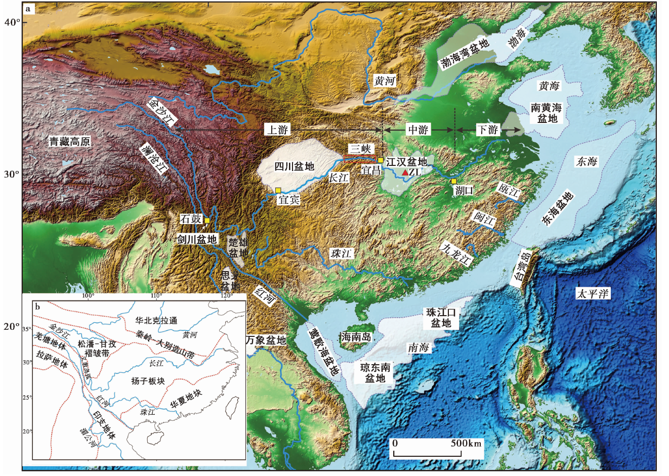
Fig. 1 Topographic map of the Yangtze River, showing the main river and the two key areas mentioned in the text.
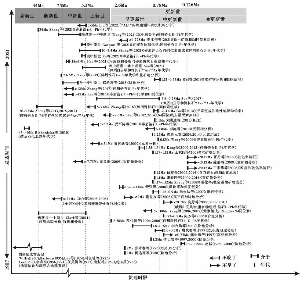
Fig. 2 Opening time of the Three Gorges summarized from the previous studies(modified by LI Ya-wei, 2021).
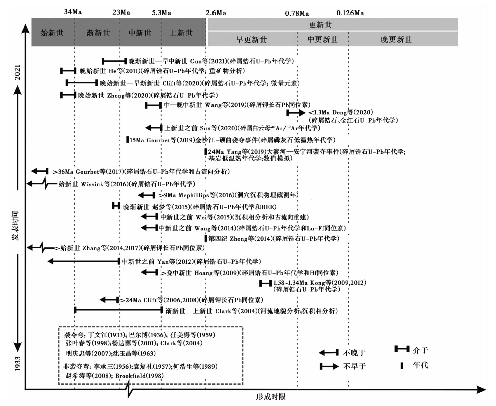
Fig. 3 The forming time of the First Bend summarized from the previous studies(modified by LI Ya-wei, 2021).
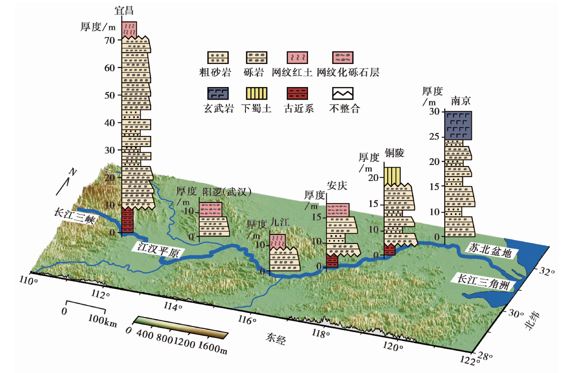
Fig. 4 Profile and location of gravel layers in the Yangtze River(cited from Zheng, 2015).
| 物源指标将钻孔划分为3个阶段, 阶段Ⅲ(109.56~117.0m)与前2个阶段的粒度参数均相差很大, 说明水动力条件显著增强, 混杂了远源物质。 | 示踪结果距今0.97~ 1.12Ma | 三峡切穿时限马永法等, | 文献来源沉积物粒度和 砾石砾态 |
|---|---|---|---|
| 环境磁学参数 | 在孔深100~110m附近, 稳定磁性矿物成分、 沉积物磁化率、 饱和等温剩磁、 非磁滞剩磁磁化率值均出现突增, 说明三峡被切开, 接受上游的远源物质。 | 距今1.17~ 1.12Ma | 张玉芬等, |
| 重矿物组合 与指数 | 自钻孔岩心深度110m开始向上, 水动力条件加强, 沉积速率加快, 重矿物的数量特征发生明显突变, 特征矿物的组合与现代长江相同。 | 距今1.1Ma | 康春国等, |
| 普通辉石特征 | 自钻孔深度104m开始向上, 普通辉石的含量明显增多, 种类也明显多样化, 且含钛普通辉石(玫瑰红色调)首次出现。 | 距今1.1Ma | 杨建等, |
| 峨眉山玄武岩 | 钻孔中含峨眉山玄武岩岩屑的岩心层位最大深度为156m。 | 距今1.7Ma | |
| 稀土元素特征 | 钻孔深度108m以浅的沉积物与金沙江、 嘉陵江沉积物的稀土元素特征最为相似, 主要物源区应该是金沙江和嘉陵江的沉积物。 | 距今1Ma | 刘引迪等, |
| 碎屑锆石 U-Pb年龄 | 样品年龄峰值257Ma的出现表明长江沉积物中已含有峨眉山玄武岩成分, 2个年龄分别为(14.8±0.4)Ma和(16.5±0.3)Ma的锆石的出现, 预示着长江源头已到达青藏高原。 | 距今0.8Ma | Wang et al., |
| 微量及稀土 元素分析 | 微量及稀土元素变化在1.25Ma BP以后变化微弱, 江汉盆地物源趋于稳定。 | 距今1.25Ma | 袁胜元等, |
| 全岩Nd 同位素组成 及稀土元素 | 于上新世第四纪交界处捕捉到了峨眉山玄武岩的物源信号, 与现今长江类似的古长江在第四纪之前就已存在并向江汉盆地提供物源。 | 第四纪之前 | Shao et al., |
| 碎屑钾长石Pb 同位素 | 钻孔底部沉积物的Pb同位素组成即与松潘-甘孜褶皱带的Pb同位素重叠, 说明在晚上新世时青藏东缘已经是江汉盆地的物源区。 | 至少于晚上新世 | Zhang et al., |
| 碎屑白云母 Ar-Ar年龄 | 在周老孔样品中检测到与大渡河样品重合的年轻白云母(年龄<70Ma), 这些年轻白云母在江汉盆地的周缘水系中均未出现。 | 距今2.8~1.2Ma | Sun et al., |
| 重矿物组合 | 将宜昌砾石层的重矿物组成与周老孔中的示踪指标(磁化率特征、 元素组成、 辉石含量)进行对比, 发现在距今1.12Ma出现长江上游水系的物质供应。 | 距今1.12Ma | Wei et al., |
| 碎屑锆石U-Pb年代 学与重矿物组成 | 中新统地层中出现年龄<32Ma的锆石颗粒, 来自长江上游的羌塘地体和松潘-甘孜褶皱带。 | 晚渐新世 早中新世 | Yang C Q et al., |
| 碎屑锆石U-Pb 年代学 | 中新统沉积物中首次出现年龄<65Ma的新生代锆石颗粒, 这一锆石年龄是在长江上游的羌塘地块的特征年龄, 说明中新世之前长江上游并未向江汉盆地提供物源。 | 中新世 | Guo et al., |
Table1 Provenance analysis of the Zhoulao Core, Jianghan Basin of the Yangtze river
| 物源指标将钻孔划分为3个阶段, 阶段Ⅲ(109.56~117.0m)与前2个阶段的粒度参数均相差很大, 说明水动力条件显著增强, 混杂了远源物质。 | 示踪结果距今0.97~ 1.12Ma | 三峡切穿时限马永法等, | 文献来源沉积物粒度和 砾石砾态 |
|---|---|---|---|
| 环境磁学参数 | 在孔深100~110m附近, 稳定磁性矿物成分、 沉积物磁化率、 饱和等温剩磁、 非磁滞剩磁磁化率值均出现突增, 说明三峡被切开, 接受上游的远源物质。 | 距今1.17~ 1.12Ma | 张玉芬等, |
| 重矿物组合 与指数 | 自钻孔岩心深度110m开始向上, 水动力条件加强, 沉积速率加快, 重矿物的数量特征发生明显突变, 特征矿物的组合与现代长江相同。 | 距今1.1Ma | 康春国等, |
| 普通辉石特征 | 自钻孔深度104m开始向上, 普通辉石的含量明显增多, 种类也明显多样化, 且含钛普通辉石(玫瑰红色调)首次出现。 | 距今1.1Ma | 杨建等, |
| 峨眉山玄武岩 | 钻孔中含峨眉山玄武岩岩屑的岩心层位最大深度为156m。 | 距今1.7Ma | |
| 稀土元素特征 | 钻孔深度108m以浅的沉积物与金沙江、 嘉陵江沉积物的稀土元素特征最为相似, 主要物源区应该是金沙江和嘉陵江的沉积物。 | 距今1Ma | 刘引迪等, |
| 碎屑锆石 U-Pb年龄 | 样品年龄峰值257Ma的出现表明长江沉积物中已含有峨眉山玄武岩成分, 2个年龄分别为(14.8±0.4)Ma和(16.5±0.3)Ma的锆石的出现, 预示着长江源头已到达青藏高原。 | 距今0.8Ma | Wang et al., |
| 微量及稀土 元素分析 | 微量及稀土元素变化在1.25Ma BP以后变化微弱, 江汉盆地物源趋于稳定。 | 距今1.25Ma | 袁胜元等, |
| 全岩Nd 同位素组成 及稀土元素 | 于上新世第四纪交界处捕捉到了峨眉山玄武岩的物源信号, 与现今长江类似的古长江在第四纪之前就已存在并向江汉盆地提供物源。 | 第四纪之前 | Shao et al., |
| 碎屑钾长石Pb 同位素 | 钻孔底部沉积物的Pb同位素组成即与松潘-甘孜褶皱带的Pb同位素重叠, 说明在晚上新世时青藏东缘已经是江汉盆地的物源区。 | 至少于晚上新世 | Zhang et al., |
| 碎屑白云母 Ar-Ar年龄 | 在周老孔样品中检测到与大渡河样品重合的年轻白云母(年龄<70Ma), 这些年轻白云母在江汉盆地的周缘水系中均未出现。 | 距今2.8~1.2Ma | Sun et al., |
| 重矿物组合 | 将宜昌砾石层的重矿物组成与周老孔中的示踪指标(磁化率特征、 元素组成、 辉石含量)进行对比, 发现在距今1.12Ma出现长江上游水系的物质供应。 | 距今1.12Ma | Wei et al., |
| 碎屑锆石U-Pb年代 学与重矿物组成 | 中新统地层中出现年龄<32Ma的锆石颗粒, 来自长江上游的羌塘地体和松潘-甘孜褶皱带。 | 晚渐新世 早中新世 | Yang C Q et al., |
| 碎屑锆石U-Pb 年代学 | 中新统沉积物中首次出现年龄<65Ma的新生代锆石颗粒, 这一锆石年龄是在长江上游的羌塘地块的特征年龄, 说明中新世之前长江上游并未向江汉盆地提供物源。 | 中新世 | Guo et al., |
| 物源指标孔深189.8~215.8m之间(距今3.2~3.5Ma)沉积物的碎屑锆石年龄以100~150Ma居多, 主要来自长江下游的白垩纪岩体; 189.8m以浅沉积物的碎屑锆石年龄呈现多峰态分布, 始现长江上游的物源信息。 | 示踪结果不晚于距今3.2Ma | 三峡切穿时限贾军涛等, | 文献来源碎屑锆石 U-Pb年代学 |
|---|---|---|---|
| 元素地球化学 | 距今约3.1Ma时, 钻孔中的元素比值都出现由高到低的显著变化; 而距今3.1Ma之后的元素比值变化不大, 说明晚上新世时本区物源曾发生重大变化, 表现为沉积物来源由近源转变为远源, 源岩由以酸性长英质矿物为主转变为以基性矿物为主。 | 晚上新世 | 黄湘通等, |
| 稀土元素(REE)和 Nd同位素 | 钻孔中上新世沉积物主要来自近源的近酸性物源区, 近似于长江中下游地区, 而第四纪沉积物则来自更广泛的物源区。 | 第四纪 | 杨守业等, |
| 重矿物组合 | 中更新世后, 重矿物种类更加丰富, 河口区逐渐接受了长江中下游和上游地区的物源。 | 中更新世 | 陈静等, |
| 磁化率与粒度 | 将钻孔分为4个阶段, 阶段Ⅰ(247~234m)沉积物的磁化率与粒度第1次发生突变, 指示物源区的扩张。 | 距今2.32~2.13Ma | 舒强等, |
| 磁性矿物类型 | 晚更新世晚期出现细粒赤铁矿和磁铁矿, 认为是由长江上游物源的加入造成的。 | 晚更新世晚期 | 王张华等, |
| 岩石磁学特征 | 晚更新世晚期以来, 细颗粒沉积物的磁性明显增强, 反映现代长江三角洲地区的物源区不断扩大。 | 早更新世中期 | 张丹等, |
| 重矿物组合 | 距今7.75~6.89Ma阶段, 重矿物组合与长江干流相似, 矿物成熟度高, 物源区以远源为主。 | 距今7.75Ma以前 | 郑良烁, |
| 元素地球化学特征 | 在早更新世中期中更新世沉积物中检测到了峨眉山玄武岩的成分及碳酸盐。 | 距今1.0~1.2Ma | Gu et al., |
| 独居石 Th-U-Pb年代学、 REE、 Sr-Nd同位素 | 钻孔中的上新世沉积物主要由近源地区长英质多硅物质供给, 而第四纪沉积物中铁镁质的火成岩物质占比更大, 认为这来自于上游峨眉山地区; 独居石U-Pb年龄谱则表明上新世沉积物为现代长江下游的近源供给, 而年龄<25Ma的独居石来自上游滇藏地区, 其初现的层位代表长江贯通。 | 距今2.58Ma | Yang et al., |
Table2 Provenance analysis of the Yangtze river delta and the Subei Basin
| 物源指标孔深189.8~215.8m之间(距今3.2~3.5Ma)沉积物的碎屑锆石年龄以100~150Ma居多, 主要来自长江下游的白垩纪岩体; 189.8m以浅沉积物的碎屑锆石年龄呈现多峰态分布, 始现长江上游的物源信息。 | 示踪结果不晚于距今3.2Ma | 三峡切穿时限贾军涛等, | 文献来源碎屑锆石 U-Pb年代学 |
|---|---|---|---|
| 元素地球化学 | 距今约3.1Ma时, 钻孔中的元素比值都出现由高到低的显著变化; 而距今3.1Ma之后的元素比值变化不大, 说明晚上新世时本区物源曾发生重大变化, 表现为沉积物来源由近源转变为远源, 源岩由以酸性长英质矿物为主转变为以基性矿物为主。 | 晚上新世 | 黄湘通等, |
| 稀土元素(REE)和 Nd同位素 | 钻孔中上新世沉积物主要来自近源的近酸性物源区, 近似于长江中下游地区, 而第四纪沉积物则来自更广泛的物源区。 | 第四纪 | 杨守业等, |
| 重矿物组合 | 中更新世后, 重矿物种类更加丰富, 河口区逐渐接受了长江中下游和上游地区的物源。 | 中更新世 | 陈静等, |
| 磁化率与粒度 | 将钻孔分为4个阶段, 阶段Ⅰ(247~234m)沉积物的磁化率与粒度第1次发生突变, 指示物源区的扩张。 | 距今2.32~2.13Ma | 舒强等, |
| 磁性矿物类型 | 晚更新世晚期出现细粒赤铁矿和磁铁矿, 认为是由长江上游物源的加入造成的。 | 晚更新世晚期 | 王张华等, |
| 岩石磁学特征 | 晚更新世晚期以来, 细颗粒沉积物的磁性明显增强, 反映现代长江三角洲地区的物源区不断扩大。 | 早更新世中期 | 张丹等, |
| 重矿物组合 | 距今7.75~6.89Ma阶段, 重矿物组合与长江干流相似, 矿物成熟度高, 物源区以远源为主。 | 距今7.75Ma以前 | 郑良烁, |
| 元素地球化学特征 | 在早更新世中期中更新世沉积物中检测到了峨眉山玄武岩的成分及碳酸盐。 | 距今1.0~1.2Ma | Gu et al., |
| 独居石 Th-U-Pb年代学、 REE、 Sr-Nd同位素 | 钻孔中的上新世沉积物主要由近源地区长英质多硅物质供给, 而第四纪沉积物中铁镁质的火成岩物质占比更大, 认为这来自于上游峨眉山地区; 独居石U-Pb年龄谱则表明上新世沉积物为现代长江下游的近源供给, 而年龄<25Ma的独居石来自上游滇藏地区, 其初现的层位代表长江贯通。 | 距今2.58Ma | Yang et al., |
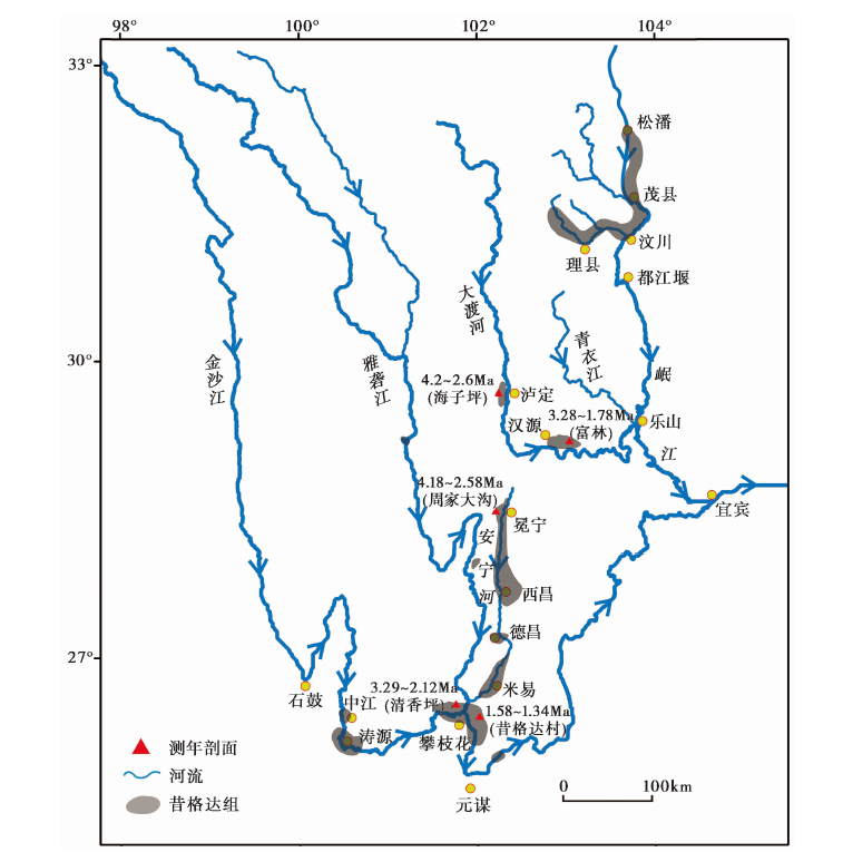
Fig. 5 The distribution range and dating profiles of the Xigeda Formation (The Chronological data incited from QIAN Fang et al., 1984and Kong et al., 2009).
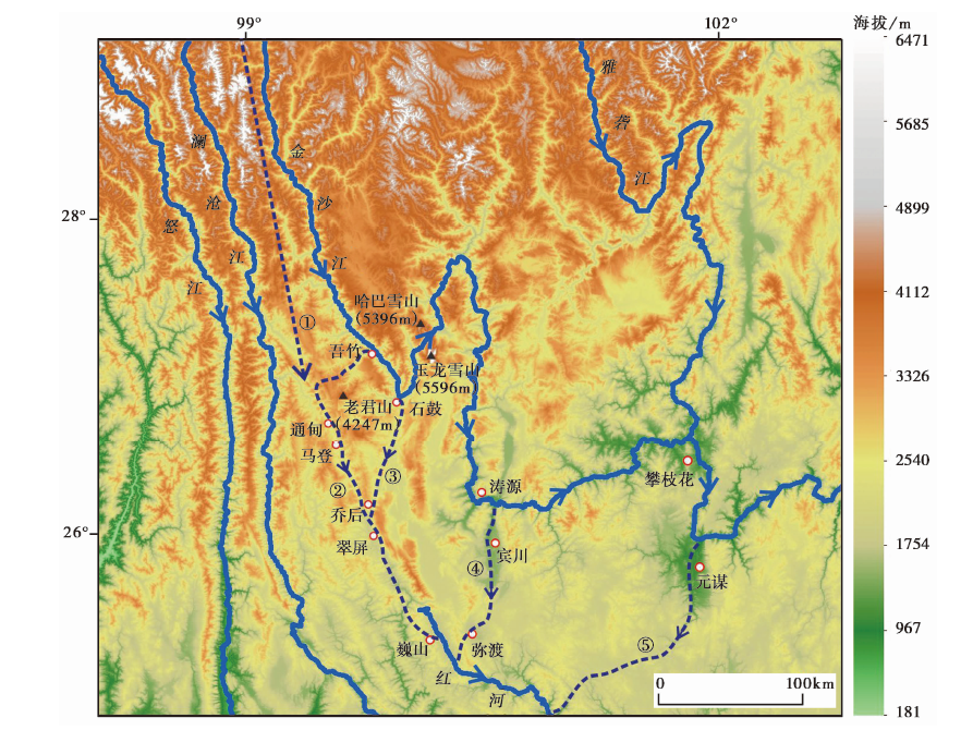
Fig. 6 Schematic diagram of the southern flow path of the Jinsha River.
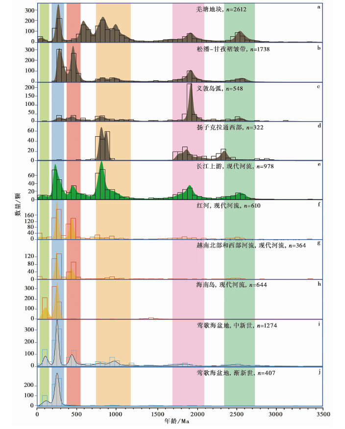
Fig. 7 Detrital zircon U-Pb age distributions of samples from the Yinggehai Basin, modern rivers(Red River, rivers in Western Hainan, Vietnam and the upper Yangtze River)and main tectonic units in the upper Yangtze.
| [1] | 巴尔博, 谢家荣译. 1935. 扬子江流域地文发育史[M]. 北京: 国立北平研究院地质调查研究所:1734. |
| Barbour G, XIE Jia-rongtransl. 1935. Physiographic History of the Yangtze[M]. Beijing: Institute of Geological Survey, National Peking Research Institute: 1734. (in Chinese) | |
| [2] | 常隆庆. 1937. 宁属七县地质矿产[R]. 成都: 四川省建设厅: 166. |
| CHANG Long-qing. 1937. The geological minerals of Ningshu[R]. Sichuan Provincial Construction Department, Chengdu: 166. (in Chinese) | |
| [3] | 陈华慧, 马祖陆. 1987. 江汉平原下更新统[J]. 地球科学, 12(2): 129135. |
|
CHEN Hua-hui, MA Zu-lu. 1987. Lower Pleistocene series in Jianghan Piain[J]. Earth Science, 12(2): 129135. (in Chinese)
DOI URL |
|
| [4] | 陈静, 王哲, 王张华, 等. 2007. 长江三角洲东西部晚新生代地层中的重矿物差异及其物源意义[J]. 第四纪研究, 27(5): 700708. |
| CHEN Jing, WANG Zhe, WANG Zhang-hua, et al. 2007. Heavy mineral distribution and its provenance implication in late Cenozoic sediments in western and eastern area of the Changjiang River Delta[J]. Quaternary Sciences, 27(5): 700708. (in Chinese) | |
| [5] | 陈立德, 邵长生. 2016. 江汉-洞庭盆地第四系划分与对比[M]. 武汉: 中国地质大学出版社:192. |
| CHEN Li-de, SHAO Chang-sheng. 2016. The Quaternary Division and Comparison of Jianghan-Dongting Basin[M]. China University of Geosciences Press, Wuhan: 192. (in Chinese) | |
| [6] | 何浩生, 何科昭, 朱祥民, 等. 1989. 滇西北金沙江河流袭夺的研究: 兼与任美锷先生商榷[J]. 现代地质, 5(3): 319330. |
| HE Hao-sheng, HE Ke-zhao, ZHU Xiang-min, et al. 1989. A discussion on the problem of river-capturing of the Jinshajiang River in northwest Yunnan[J]. Modern Geoscience, 5(3): 319330. (in Chinese) | |
| [7] | 黄万波, 王景文, 邱铸鼎, 等. 1978. 中国地质科学院地层古生物论文集编委会编地层古生物论文集(第七辑)[C]. 北京: 地质出版社: 3039. |
| HUANG Wan-bo, WANG Jing-wen, QIU Zhu-ding, et al. 1978. The Proceedings of stratigraphic paleontology edited by Chinese Academy of Geological Sciences(Vol. 7)[C]. Geological Publishing House, Beijing: 3039. (in Chinese) | |
| [8] | 黄湘通, 郑洪波, 杨守业, 等. 2009. 长江三角洲DY03孔沉积物元素地球化学及其物源示踪意义[J]. 第四纪研究, 29(2): 299307. |
| HUANG Xiang-tong, ZHENG Hong-bo, YANG Shou-ye, et al. 2009. Investigation of sedimentary geochemistry of core DY03 in the Yangtze Delta: implication to tracing provenance[J]. Quaternary Science, 29(2): 299307. (in Chinese) | |
| [9] | 贾军涛, 郑洪波, 黄湘通, 等. 2010. 长江三角洲晚新生代沉积物碎屑锆石U-Pb年龄及其对长江贯通的指示[J]. 科学通报, 55(4): 350358. |
|
JIA Jun-tao, ZHENG Hong-bo, HUANG Xiang-tong, et al. 2010. Detrital zircon U-Pb ages of late Cenozoic sediments from the Yangtze delta: Implication for the evolution of the Yangtze River[J]. Chinese Science Bulletin, 55(4): 350358. (in Chinese)
DOI URL |
|
| [10] | 康春国, 李长安, 张玉芬, 等. 2014. 宜昌砾石层重矿物组合特征及物源示踪分析[J]. 地质学报, 88(2): 254262. |
|
KANG Chun-guo, LI Chang-an, ZHANG Yu-fen, et al. 2014. Heavy mineral characteristic of the Yichang gravel layers and provenance tracing[J]. Acta Geologica Sinica, 88(2): 254262. (in Chinese)
DOI URL |
|
| [11] | 李承三. 1956. 长江发育史[J]. 人民长江, (12): 58. |
| LI Cheng-san. 1956. The evolutionary history of the Yangtze River[J]. Yangtze River, (12): 58. (in Chinese) | |
| [12] | 李庭, 李长安, 康春国, 等. 2010. 宜昌砾石层的沉积环境及地貌意义[J]. 中国地质, 37(2): 438445. |
| LI Ting, LI Chang-an, KANG Chun-guo, et al. 2010. Sedimentary environment and geomorphological significance of the gravel bed in Yichang[J]. Geology in China, 37(2): 438445. (in Chinese) | |
| [13] | 李亚伟. 2021. 江汉盆地晚新生代沉积对三峡贯通的指示[D]. 武汉: 中国地质大学:1115. |
| LI Ya-wei. 2021. Evidence from Late Cenozoic sediments in Jianghan Basin: implication for the evolution of the Three Gorges[D]. China University of Geosciences, Wuhan: 1115. (in Chinese) | |
| [14] |
李亚伟, 李长安, 张玉芬, 等. 2019. 长江流域碎屑锆石U-Pb年龄物源示踪研究进展[J]. 地震地质, 41(2): 521544. doi: 10.3969/j.issn.0253-4967.
DOI |
| LI Ya-wei, LI Chang-an, ZHANG Yu-fen, et al. 2019. Progress of detrital zircon chronology in sediment provenance studies in the Yangtze River Basin[J]. Seismology and Geology, 41(2): 521544. (in Chinese) | |
| [15] | 林旭, 李玲玲, 刘静, 等. 2022. 长江早更新世向江汉盆地输送碎屑物质: 来自碎屑锆石U-Pb年龄的约束[J]. 地球科学, 42(4): 5663. |
| LIN Xu, LI Ling-ling, LIU Jing, et al. 2022. The Yangtze River contributed detrital materials to the Jianghan Basin during the Early Pleistocene: Constraints from detrital zircon U-Pb ages[J]. Earth Science, 42(4): 5663. (in Chinese) | |
| [16] | 林旭, 刘海金, 吴中海, 等. 2021. 宜昌第四纪砾石层钾长石主微量元素物源研究及其地质意义[J]. 地质力学学报, 27(6): 10241034. |
| LIN Xu, LIU Hai-jin, WU Zhong-hai, et al. 2021. Provenance study on geochemical elements of detrital K-feldspar in Quaternary gravel layer in Yichang and its geological significance[J]. Journal of Geomechanics, 27(6): 10241034. (in Chinese) | |
| [17] |
林旭, 刘静. 2019. 江汉和洞庭盆地与周缘造山带盆山耦合研究进展[J]. 地震地质, 41(2): 499520. doi: 10.3969/j.issn.02534967.
DOI |
| LIN Xu, LIU Jing. 2019. A review of mountain-basin coupling of Jianghan and Dongting Basins with their surrounding mountains[J]. Seismology and Geology, 41(2): 499520. (in Chinese) | |
| [18] | 刘季辰, 赵汝钧. 1924. 江苏地质志[M]. 北京: 地质出版社:310. |
| LIU Ji-chen, ZHAO Ru-jun. 1924. Bureau of Geology and Mineral Resources of Jiangsu Province[M]. Geological Publishing House, Beijing: 310. (in Chinese) | |
| [19] | 刘廷栋. 1977. 中国地质科学院地质力学研究所编中国第四纪冰川地质文集[C]. 北京: 地质出版社: 164178. |
| LIU Ting-dong. 1977. The Proceedings of Quaternary glacial geology in China: Institute of Geomechanics, Chinese Academy of Geological Sciences[C]. Beijing: Geological Publishing House: 164178. (in Chinese) | |
| [20] | 刘兴诗. 1983. 四川盆地的第四纪[M]. 成都: 四川科学技术出版社:1217. |
| LIU Xing-shi. 1983. The Quaternary Sediments of the Sichuan Basin[M]. Sichuan Science and Technology Press, Chengdu: 1217. (in Chinese) | |
| [21] | 刘引迪, 李长安, 袁胜元. 2011. 江汉盆地周老孔0-108 m沉积物的稀土元素特征及其物源判别[J]. 地质科技情报, 30(1): 4750. |
| LIU Yin-di, LI Chang-an, YUAN Sheng-yuan. 2011. Geochemistry of REE and provenance of sediments from 0-108m Zhoulao borehole in Jianghan Plain[J]. Geological Science and Technology Information, 30(1): 4750. (in Chinese) | |
| [22] | 罗运利, 刘东生. 1998. 昔格达组沉积环境演化与旋回地层学研究[J]. 第四纪研究, 18(4): 373. |
| LUO Yun-li, LIU Tung-sheng. 1998. Sedimentary environment evolution and cycle stratigraphy of Xigeda Formation[J]. Quaternary Sciences, 18(4): 373. (in Chinese) | |
| [23] | 马宏杰. 2013. 中国西南横断山地区新生代地层学及古环境变化研究[D]. 昆明: 昆明理工大学:1183. |
| MA Hong-jie. 2013. The Cenozoic stratigraphy and paleoenvironmental changes in Hengduan Mountains, southwest China[D]. Kunming University of Science and Technology, Kunming: 1183. (in Chinese) | |
| [24] | 马永法, 李长安, 王秋良, 等. 2007. 江汉盆地周老镇钻孔砾石统计及其与长江三峡贯通的关系[J]. 地质科技情报, 26(2): 4044. |
| MA Yong-fa, LI Chang-an, WANG Qiu-liang, et al. 2007. Statistics of gravels from a bore in Zhoulao Town, Jianghan Plain and its relationship with cut-through of the Yangtze Three Gorges, China[J]. Geological Science and Technology Information, 26(2): 4044. (in Chinese) | |
| [25] | 钱方, 徐树金, 陈富斌, 等. 1984. 昔格达组磁性地层的研究[J]. 山地研究, 2(4): 275282. |
| QIAN Fang, XU Shu-jin, CHEN Fu-bin, et al. 1984. Study on the paleomagnetism of the Xigeda Formation[J]. Mountain Research, 2(4): 275282. (in Chinese) | |
| [26] | 覃琼, 徐亚东, 张克信, 等. 2018. 滇西剑川盆地剑川组火山事件的定年和古环境研究[J]. 地质学报, 92(10): 20962105. |
| QIN Qiong, XU Ya-dong, ZHANG Ke-xin, et al. 2018. Geological dating and paleoenvironmental research on volcanic events of the Jianchuan Formation in the Jianchuan Basin, Western Yunnan Province[J]. Acta Geologica Sinica, 92(10): 20962105. (in Chinese) | |
| [27] |
任美锷, 包浩生, 韩同春, 等. 1959. 云南西北部金沙江河谷地貌与河流袭夺问题[J]. 地理学报, 25(2): 135155.
DOI |
| REN Mei-e, BAO Hao-sheng, HAN Tong-chun, et al. 1959. Geomorphology of the Jinshajiang River valley and its river capture in northwestern Yunnan[J]. Acta Geographica Sinica, 25(2): 135155. (in Chinese) | |
| [28] | 邵家骥, 刘志平, 杨武, 等. 2008. 南京附近新近纪岩石地层若干问题探讨[J]. 地质学刊, 32(4): 257262. |
| SHAO Jia-ji, LIU Zhi-ping, YANG Wu, et al. 2008. Discussion on some problems of Neogene lithostratigraphy near Nanjing[J]. Journal of Geology, 32(4): 257262. (in Chinese) | |
| [29] | 沈阳, 郑远川, 张爱萍, 等. 2019. 滇西剑川始新世富碱岩浆岩锆石U-Pb年代学与Sr-Nd-Hf同位素地球化学及其对岩石成因的制约[J]. 岩石学报, 35(3): 849866. |
|
SHEN Yang, ZHENG Yuan-chuan, ZHANG Ai-ping, et al. 2019. Zircon U-Pb geochronology, geochemistry and Sr-Nd-Hf isotopes of the Eocene alkali-rich magmatic rocks in the Jianchuan area of western Yunnan and their implications for petrogenesis[J]. Acta Petrologica Sinica, 35(3): 849866. (in Chinese)
DOI URL |
|
| [30] | 沈玉昌. 1965. 长江上游河谷地貌[M]. 北京: 科学出版社:2335. |
| SHEN Yu-chang. 1965. The Geomorphology of the Valley in the Upper Reaches of Yangtze River[M]. Science Press, Beijing: 2335. (in Chinese) | |
| [31] |
沈玉昌, 杨逸畴. 1963. 滇西金沙江袭夺问题的新探讨[J]. 地理学报, 29(2): 87108.
DOI |
| SHEN Yu-chang, YANG Yi-chou. 1963. New research on the problem of river-capture of Ching-Sha-Chiang(the upper Yangtze), Western Yunnan, China[J]. Acta Geographica Sinica, 29(2): 87108. (in Chinese) | |
| [32] | 舒强, 张茂恒, 赵志军, 等. 2008. 苏北盆地XH-1钻孔晚新生代沉积记录特征及其与长江贯通时间的关联[J]. 地层学杂志, 32(3): 308314. |
| SHU Qiang, ZHANG Mao-heng, ZHAO Zhi-jun, et al. 2008. Sedimentary record from the XH-1 core in North Jiangsu Basin and its implication on the Yangtze River run-through time. Journal of Stratigraphy[J]. 32(3): 308314. (in Chinese) | |
| [33] | 田陵君, 李平忠, 罗雁, 等. 1996. 长江三峡河谷发育史[M]. 成都: 西南交通大学出版社:2027. |
| TIAN Ling-jun, LI Ping-zhong, LUO Yan, et al. 1996. The Formation History if the Three Gorges, Yangtze River[M]. Southwest Jiaotong University Press, Chengdu: 2027. (in Chinese) | |
| [34] | 王书兵, 蒋复初, 田国强, 等. 2020. 滇西北剑川盆地新近系地层时代的新认识及构造意义[J]. 第四纪研究, 40(1): 2839. |
| WANG Shu-bing, JIANG Fu-chu, TIAN Guo-qiang, et al. 2020. New insights into Neogene stratigraphic age in the Jianchuan Basin, northwest Yunnan and its tectonic significance[J]. Quaternary Sciences, 40(1): 2839. (in Chinese) | |
| [35] | 王书兵, 乔彦松, 赵志中, 等. 2006. 泸定昔格达组时代认定与环境记录[J]. 第四纪研究, 26(2): 257264. |
| WANG Shu-bing, QIAO Yan-song, ZHAO Zhi-zhong, et al. 2006. The age and environmental records of Xigeda Formation, Luding[J]. Quaternary Sciences, 26(2): 257264. (in Chinese) | |
| [36] | 王张华, 张丹, 李晓, 等. 2008. 长江三角洲晚新生代沉积物磁性特征和磁性矿物及其指示意义[J]. 中国地质, 35(4): 670682. |
| WANG Zhang-hua, ZHANG Dan, LI Xiao, et al. 2008. Magnetic properties and relevant minerals of late Cenozoic sediments in the Yangtze River delta and their implications[J]. Geology in China, 35(4): 670682. (in Chinese) | |
| [37] | 向芳. 2004. 长江三峡的贯通与江汉盆地西缘及邻区的沉积响应[D]. 成都: 成都理工大学:1176. |
| XIANG Fang. 2004. The connection of the Three Gorges of the Yangtze River and the sedimentary response of the western margin of Jianghan Basin and its surrounding areas[D]. Chengdu University of Science and Technology, Chengdu: 1176. (in Chinese) | |
| [38] | 向芳, 朱利东, 王成善, 等. 2006. 宜昌地区第四纪沉积物中玄武岩砾石特征及其与长江三峡贯通的关系[J]. 地球科学与环境学报, 28(2): 610. |
| XIANG Fang, ZHU Li-dong, WANG Cheng-shan, et al. 2006. Character of basaltic gravels in Quaternary sediments in Yichang area and its relationship with formation of Yangtze Three Gorges[J]. Journal of Earth Science and Environment, 28(2): 610. (in Chinese) | |
| [39] | 许学汉, 裴静娴. 1987. 渡口西昌区域第四系形成与新构造活动的热发光年龄及发展史研究[J]. 地质科学, 22(4): 374383. |
| XU Xue-han, PEI Jing-xian. 1987. The thermoluminescence age and history of Quaternary formation and neotectonic activity in Dukou-Xichang region[J]. Chinese Journal of Geology, 22(4): 374383. (in Chinese) | |
| [40] | 阎德发. 1978. 湖北荆襄地区掇刀石组的时代[J]. 古脊椎动物与古人类, 16(1): 3234, 88. |
| YAN De-fa. 1978. The age of Duodaoshi Formation in the Jingzhou-Xiangyang, Hubei area[J]. Vertebrata Palasiatica, 16(1): 3234, 88. (in Chinese) | |
| [41] |
杨达源. 1988. 长江三峡阶地的成因机制[J]. 地理学报, 43(2): 120126.
DOI |
|
YANG Da-yuan. 1988. Genetic mechanism of the alluvial terraces along the Three-Gorges course of the Changjiang River[J]. Acta Geographica Sinica, 43(2): 120126. (in Chinese)
DOI |
|
| [42] | 杨达源. 2006. 长江地貌过程[M]. 北京: 地质出版社:1318. |
| YANG Da-yuan. 2006. Geomorphic Process of Yangtze River[M]. Geological Publishing House, Beijing: 1318. (in Chinese) | |
| [43] | 杨怀仁, 唐日长. 1999. 长江中游荆江变迁研究[M]. 北京: 中国水利水电出版社:2732. |
| YANG Huai-ren, TANG Ri-chang. 1999. Study on the Changes of Jingjiang River in the Middle Reaches of Yangtze River[M]. China Water Power Press, Beijing: 2732. (in Chinese) | |
| [44] | 杨建, 李长安, 康春国, 等. 2009. 江汉盆地沉积物中普通辉石的特征及物源示踪意义[J]. 第四纪研究, 29(5): 10001007. |
| YANG Jian, LI Chang-an, KANG Chun-guo, et al. 2009. Characteristics and provenance tracing significance of common pyroxene of the Jianghan Basin[J]. Quaternary Sciences, 29(5): 10001007. (in Chinese) | |
| [45] | 杨建, 李长安, N’djidit J D, 等. 2014. 峨眉山玄武岩作为长江上游特征源岩对三峡贯通的指示[J]. 地球科学, 39(4): 431442. |
| YANG Jian, LI Chang-an, N’djidit J D, et al. 2014. Emeishan Basalts as provenance indicators: implications for formation of the Three Gorges[J]. Earth Science, 39(4): 431442. (in Chinese) | |
| [46] | 杨守业, 韦刚健, 夏小平, 等. 2007. 长江口晚新生代沉积物的物源研究: REE和Nd同位素制约[J]. 第四纪研究, 27(3): 339346. |
| YANG Shou-ye, WEI Gang-jian, XIA Xiao-ping, et al. 2007. Provenance study of the late Cenozoic sediments in the Changjiang delta: REE and Nd isotopic constraints[J]. Quaternary Sciences, 27(3): 339346. (in Chinese) | |
| [47] | 袁复礼. 1957. 长江河流发育史的补充研究[J]. 人民长江, (2): 311. |
| YUAN Fu-li. 1957. The complementary study on the evolutionary history of the Yangtze River[J]. Yangtze River, (2): 311. (in Chinese) | |
| [48] | 袁复礼. 1958. 中国西南区第四纪地质的一些资料[J]. 中国第四纪研究, 1(2): 130140. |
| YUAN Fu-li. 1958. Some documents of Quaternary geology in southwest China[J]. Chinese Quaternary Studies, 1(2): 130140. (in Chinese) | |
| [49] | 袁胜元, 李长安, 张玉芬, 等. 2012. 江汉盆地沉积物微量元素特征与长江上游水系拓展[J]. 中国地质, 39(4): 10421048. |
| YUAN Sheng-yuan, LI Chang-an, ZHANG Yu-fen, et al. 2012. Trace element characteristics of sediments in Jianghan Basin: Implications for expansion of the upper reaches of the Yangtze River[J]. Geology in China, 39(4): 10421048. (in Chinese) | |
| [50] | 曾普胜. 2002. 滇西北地区岩浆活动与长江第一弯形成的关系[J]. 地理学报, 57(3): 310316. |
| ZENG Pu-sheng. 2002. Relationship between magmatic activity in northwest Yunnan and the formation of the First Bend of the Yangtze River[J]. Acta Geographica Sinica, 57(3): 310316. (in Chinese) | |
| [51] | 曾忻耕. 1965. 四川安宁河东侧的新构造运动迹象[J]. 地质论评, 23(2): 95102. |
| ZENG Xin-geng. 1965. The neotectonic movement on the east side of Anning River, Sichuan Province[J]. Geological Review, 23(2): 95102. (in Chinese) | |
| [52] | 张丹, 王张华, 卫巍, 等. 2009. 长江三角洲地区晚新生代沉积物岩石磁学特征及其物源指示意义[J]. 第四纪研究, 29(2): 308317. |
| ZHANG Dan, WANG Zhang-hua, WEI Wei, et al. 2009. Rock magnetic properties and source indications of late Cenozoic sediments in Yangtze Delta area[J]. Quaternary Sciences, 29(2): 308317. (in Chinese) | |
| [53] | 张勇, 张玉芬, 李长安, 等. 2009宜昌地区砾石层的磁性特征与物源分析[J]. 第四纪研究, 29(2): 380386. |
| ZHANG Yong, ZHANG Yu-fen, LI Chang-an, et al. 2009. Magnetic properties of the gravel layer in Yichang area and their provenance[J]. Quaternary Sciences, 29(2): 380386. (in Chinese) | |
| [54] | 张玉芬, 李长安, 周稠, 等. 2014. 长江中游高位砾石层的磁性特征与物源分析[J]. 吉林大学学报(地球科学版), 44(5): 16691677. |
| ZHANG Yu-fen, LI Chang-an, ZHOU Chou, et al. 2014. Magnetism and provenance analysis of high position gravel layer in the middle reaches of Yangtze River[J]. Journal of Jilin University(Earth Science Edition), 44(5): 16691677. (in Chinese) | |
| [55] | 张宗祜. 1994. 川滇南北构造带中段晚新生代地质研究[M]. 北京: 石油工业出版社:234253. |
| ZHANG Zong-hu. 1994. The Cenozoic Geological Study of the Middle Section of Sichuan-Yunnan North-South Tectonic Belt[M]. Petroleum Industry Press, Beijing: 234253. (in Chinese) | |
| [56] | 赵举兴. 2017. 江汉-洞庭盆地第四纪地层与沉积环境演化[D]. 武汉: 中国地质大学:1135. |
| ZHAO Ju-xing. 2017. Quaternary stratigraphy and sedimentary environment evolution of the Jianghan-Dongting Basin[D]. China University of Geosciences, Wuhan: 1135. (in Chinese) | |
| [57] | 赵希涛, 胡道功, 吴中海, 等. 2017. 长江三角洲地区晚新生代地质与环境研究进展述评[J]. 地质力学学报, 23(1): 164. |
| ZHAO Xi-tao, HU Dao-gong, WU Zhong-hai, et al. 2017. Reviews on the research of late Cenozoic geology and environment of the Yangtze River Delta area[J]. Journal of Geomechanics, 23(1): 164. (in Chinese) | |
| [58] | 赵希涛, 贾丽云, 胡道功. 2018. 内蒙河套地区黄河阶地与新近纪砾石层的发现及其对黄河发育、 中国河流古老性与河湖共存论的意义[J]. 地质学报, 92(4): 845886. |
| ZHAO Xi-tao, JIA Li-yun, HU Dao-gong. 2018. Discoveries of fluvial terraces and Neogene gravels in the Hetao area, inner Mongolia: implications for the development of the Yellow River, antiquity of Chinese rivers, and coexistence theory of rivers and lakes[J]. Acta Geologica Sinica, 92(4): 845886. (in Chinese) | |
| [59] | 郑良烁. 2013. 苏北兴化2孔晚中新世以来重矿物物源示踪研究[D]. 南京: 南京师范大学:164. |
| ZHENG Liang-shuo. 2013. The provenance analysis of Xinghua -2 core from the late Miocene, Subei Basin[D]. Nanjing Normal University, Nanjing: 164. (in Chinese) | |
| [60] | Cao K, Wang G C, Leloup P H, et al. 2019. Oligocene-Early Miocene topographic relief generation of southeastern Tibet triggered by thrusting[J]. Tectonics, 38(1): 456475. |
| [61] |
Cao L C, Jiang T, Wang Z F, et al. 2015. Provenance of Upper Miocene sediments in the Yinggehai and Qiongdongnan Basins, northwestern South China Sea: Evidence from REE, heavy minerals and zircon U-Pb ages[J]. Marine Geology, 361(3): 136146.
DOI URL |
| [62] | Chen J, Wang Z H, Chen Z, et al. 2009. Diagnostic heavy minerals in Plio-Pleistocene sediments of the Yangtze coast, China with special reference to the Yangtze River connection into the sea[J]. Geomorphology, 113(3-4): 129136. |
| [63] |
Chen Y, Yan M D, Fang X M, et al. 2017. Detrital zircon U-Pb geochronological and sedimentological study of, the Simao Basin, Yunnan: Implications for the Early Cenozoic evolution of the Red River[J]. Earth and Planetary Science Letters, 476(5): 2233.
DOI URL |
| [64] |
Clark M K, Schoenbohm L M, Royden L H, et al. 2004. Surface uplift, tectonics, and erosion of eastern Tibet from large-scale drainage patterns[J]. Tectonics, 23(1): 10.1029/2002TC00140.
DOI |
| [65] | Clift P D, Carter A, Wysocka A, et al. 2020. A Late Eocene-Oligocene through-flowing river between the Upper Yangtze and South China Sea[J]. Geochemistry, Geophysics, Geosystems, 21(7): e2020GC009046. |
| [66] | Clift P D, Sun Z. 2006. The sedimentary and tectonic evolution of the Yinggehai-Song Hong Basin and the southern Hainan margin, South China Sea: Implications for Tibetan uplift and monsoon intensification[J]. Journal of Geophysical Research: Solid Earth, 111(6): B06405. |
| [67] | Clift P D, Van Hoang L, Hinton R, et al. 2008. Evolving east Asian river systems reconstructed by trace element and Pb and Nd isotope variations in modern and ancient Red River-Song Hong sediments[J]. Geochemistry Geophysics Geosystems, 9(29): 11081119. |
| [68] | Deng B, Chew D, Jiang L, et al. 2018. Heavy mineral analysis and detrital U-Pb ages of the intracontinental Paleo-Yangzte Basin: Implications for a transcontinental source-to-sink system during Late Cretaceous time[J]. Geological Society of American Bulletin, 130(11-12): 20872109. |
| [69] | Deng B, Chew D, Mark C, et al. 2020. Late Cenozoic drainage reorganization of the paleo-Yangtze river constrained by multi-proxy provenance analysis of the Paleo-lake Xigeda[J]. Geological Society of America Bulletin, 32(3): 456467. |
| [70] |
Deng J, Wang Q F, Li G J, et al. 2014. Cenozoic tectono-magmatic and metallogenic processes in the Sanjiang region, southwestern China[J]. Earth Science Reviews, 138: 268299.
DOI URL |
| [71] |
Deng K, Yang S Y, Li C, et al. 2017. Detrital zircon geochronology of river sands from Taiwan: Implications for sedimentary provenance of Taiwan and its source link with the east China mainland[J]. Earth Science Reviews, 164: 3147.
DOI URL |
| [72] |
Feng Y, Song C Y, He P, et al. 2021. Detrital zircon U-Pb geochronology of the Jianchuan Basin, southeastern Tibetan plateau, and its implications for tectonic and paleodrainage evolution[J]. Terra Nova, 33(6): 560572.
DOI URL |
| [73] |
Fu X W, Zhu W L, Geng J, et al. 2021. The present day Yangtze River was established in the late Miocene: Evidence from detrital zircon ages[J]. Journal of Asian Earth Science, 205: 104600.
DOI URL |
| [74] | Gourbet L, Leloup P H, Paquette J L, et al. 2017. Reappraisal of the Jianchuan Cenozoic Basin stratigraphy and its implications on the SE Tibetan plateau evolution[J]. Tectonophysics, 70: 162179. |
| [75] |
Gu J W, Jing C, Sun Q L, et al. 2014. China’s Yangtze delta: Geochemical fingerprints reflecting river connection to the sea[J]. Geomorphology, 227(15): 166173.
DOI URL |
| [76] |
Guo R J, Sun X L, Li C A, et al. 2021. Cenozoic evolution of the Yangtze River: constraints from detrital zircon U-Pb ages[J]. Palaeogeography Palaeoclimatology Palaeoecology, 579(12): 110586.
DOI URL |
| [77] |
Hoke G D, Liu-Zeng J, Hren M T, et al. 2014. Stable isotopes reveal high southeast Tibetan plateau margin since the Paleogene[J]. Earth and Planetary Science Letters, 394: 270278.
DOI URL |
| [78] |
Huang C Y, Yen Y, Zhao Q H, et al. 2012. Cenozoic stratigraphy of Taiwan: Window into rifting, stratigraphy and paleoceanography of South China Sea[J]. Chinese Science Bulletin, 57(24): 31303149.
DOI URL |
| [79] |
Huang H Y, He D F, Li D, et al. 2020. Detrital zircon U-Pb ages of Paleogene deposits in the southwestern Sichuan foreland basin, China: Constraints on basin-mountain evolution along the southeastern margin of the Tibetan plateau[J]. Geological Society of American Bulletin, 132(3-4): 668686.
DOI URL |
| [80] |
Jiang T, Cao L C, Xie X N, et al. 2015. Insights from heavy minerals and zircon U-Pb ages into the middle Miocene-Pliocene provenance evolution of the Yinggehai Basin, northwestern South China Sea[J]. Sedimentary Geology, 327: 3242.
DOI URL |
| [81] |
Kong P, Granger D E, Wu F Y, et al. 2009. Cosmogenic nuclide burial ages and provenance of the Xigeda paleo-lake: Implications for evolution of the Middle Yangtze River[J]. Earth and Planet Science Letter, 278: 131141.
DOI URL |
| [82] | Kong P, Zheng Y, Caffee M W. 2012. Provenance and time constraints on the formation of the first bend of the Yangtze River[J]. Geochemistry Geophysics Geosystems, 13(6): Q060176. |
| [83] |
Lan Q, Yan Y, Huang C Y, et al. 2016. Topographic architecture and drainage reorganization in Southeast China: Zircon U-Pb chronology and Hf isotope evidence from Taiwan[J]. Gondwana Research, 36: 376389.
DOI URL |
| [84] | Lee J S, Chao Y T. 1924. Geology of the Gorge district of the Yangtze(from Ichang to Tzekuei)with special reference to the development of the Gorges[J]. Bulletin of the Geological Society of China, 3(3-4): 351392. |
| [85] |
Li J J, Xie S Y, Kuang M S. 2001. Geomorphic evolution of the Yangtze Gorges and the time of their formation[J]. Geomorphology, 41(2): 125135.
DOI URL |
| [86] |
Li Y Q, He D F, Li D, et al. 2016. Detrital zircon U-Pb geochronology and provenance of Lower Cretaceous sediments: Constraints for the northwestern Sichuan pro-foreland basin[J]. Palaeogeography Palaeoclimatology Palaeoecology, 453: 5272.
DOI URL |
| [87] |
Liu Y, Liu X B, Wang S J, et al. 2022. Late Cenozoic channel migration of the proto-Yangtze River in the delta region: Insights from cosmogenic nuclide burial dating of onshore boreholes[J]. Geomorphology, 407: 108228.
DOI URL |
| [88] | Mcphillips D, Hoke G D, Liu-Zeng J, et al. 2016. Dating the incision of the Yangtze River gorge at the First Bend using three-nuclide burial ages[J]. Geophysical Research Letters, 43(1): 109121. |
| [89] | Richardson N J, Densmore A L, Seward D, et al. 2008. Extraordinary denudation in the Sichuan Basin: Insights from low-temperature thermochronology adjacent to the eastern margin of the Tibetan plateau[J]. Journal of Geophysical Research: Solid Earth, 113(B4): B04409. |
| [90] |
Robinson R, Brezina C, Parrish R R, et al. 2014. Large rivers and orogens: The evolution of the Yarlung Tsangpo-Irrawaddy system and the eastern Himalayan syntaxis[J]. Gondwana Research, 26(1): 112121.
DOI URL |
| [91] |
Shao L, Li C A, Yuan S Y, et al. 2012. Neodymium isotopic variations of the late Cenozoic sediments in the Jianghan Basin: Implications for sediment source and evolution of the Yangtze River[J]. Journal of Asian Earth Sciences, 45(4): 5764.
DOI URL |
| [92] |
Shao L, Yuan S, Li C A, et al. 2015. Changing provenance of late Cenozoic sediments in the Jianghan Basin[J]. Geoscience Frontiers, 6(4): 605615.
DOI URL |
| [93] |
Shen C B, Donelick R A, O’Sullivan P B, et al. 2012. Provenance and hinterland exhumation from LA-ICP-MS zircon U-Pb and fission-track double dating of Cretaceous sediments in the Jianghan Basin, Yangtze block, central China[J]. Sedimentary Geology, 281: 194207.
DOI URL |
| [94] | Shen X M, Tian Y T, Li D W, et al. 2016. Oligocene-Early Miocene river incision near the first bend of the Yangze River: Insights from apatite(U-Th-Sm)/He thermochronology[J]. Tectonophysics, 687: 567577. |
| [95] |
Sorrel P, Eymard I, Leloup P H, et al. 2017. Wet tropical climate in SE Tibet during the Late Eocene[J]. Scientific Reports, 7(1): 7809.
DOI PMID |
| [96] |
Sun X L, Kuiper K F, Tian Y T, et al. 2020. 40Ar/39Ar mica dating of late Cenozoic sediments in SE Tibet: implications for sediment recycling and drainage evolution[J]. Journal of the Geological Society, 177(4): 843854.
DOI URL |
| [97] |
Sun X L, Li C A, Kuiper K F, et al. 2018. Geochronology of detrital muscovite and zircon constrains the sediment provenance changes in the Yangtze River during the late Cenozoic[J]. Basin Research, 30(4): 636649.
DOI URL |
| [98] | Sun X L, Tian Y T, Kuiper K F, et al. 2021. No Yangtze River prior to the late Miocene: Evidence from detrital muscovite and K-feldspar 40Ar/39Ar geochronology[J]. Geophysical Research Letters, 48(5): e2020GL089903. |
| [99] | Van Hoang L, Wu F Y, Clift P D, et al. 2009. Evaluating the evolution of the Red River system based on in situ U-Pb dating and Hf isotope analysis of zircons[J]. Geochemistry, Geophysics, Geosystems, 10(11): Q11008. |
| [100] |
Wang C, Liang X Q, Xie Y H, et al. 2015. Late Miocene provenance change on the eastern margin of the Yinggehai-Song Hong Basin, South China Sea: evidence from U-Pb dating and Hf isotope analyses of detrital zircons[J]. Marine and Petroleum Geology, 61: 123139.
DOI URL |
| [101] | Wang J T, Li C A, Yang Y, et al. 2010. Detrital zircon geochronology and provenance of core sediments in Zhoulao Town, Jianghan Plain, China[J]. Journal of Earth Science, 21(3): 257271. |
| [102] |
Wang L C, Shen L J, Liu C L, et al. 2020. Evolution of the paleo-Mekong River in the Early Cretaceous: Insights from the provenance of sandstones in the Vientiane Basin, central Laos[J]. Palaeogeography Palaeoclimatology Palaeoecology, 545: 109651.
DOI URL |
| [103] |
Wang L C, Shen L J, Liu C L, et al. 2021. The late Cretaceous souce-to-sink system at the eastern margin of the Tibetan plateau: Insights from the provenance of the Lanping Basin[J]. Geoscience Frontiers, 12(3): 101102.
DOI URL |
| [104] |
Wang P, Zheng H B, Liu S F, et al. 2018. Late Cretaceous drainage reorganization of the Middle Yangtze River[J]. Lithosphere, 10(3): 392405.
DOI URL |
| [105] | Wang P, Zheng H B, Wang Y D, et al. 2021. Sedimentology, geochronology, and provenance of the late Cenozoic “Yangtze Gravel”: Implications for Lower Yangtze River reorganization and tectonic evolution in southeast China[J]. Geological Society of America Bulletin, 134(1-2): 463486. |
| [106] |
Wang W, Bidgoli T, Yang X, et al. 2018. Source-to-sink links between East Asia and Taiwan from detrital zircon geochronology of the Oligocene Huagang Formation in the East China Sea Shelf Basin[J]. Geochemistry Geophysics Geosystems, 19(10): 36733688.
DOI URL |
| [107] |
Wei C Y, Voinchet P, Zhang Y F, et al. 2020. Chronology and provenance of the Yichang gravel layer deposits in the Jianghan Basin, middle Yangtze River Valley, China: Implications for the timing of channelization of the Three Gorges Valley[J]. Quaternary International, 550: 3954.
DOI URL |
| [108] |
Wei H H, Wang E, Wu G L, et al. 2016. No sedimentary records indicating southerly flow of the paleo-Upper Yangtze River from the first bend in southeastern Tibet[J]. Gondwana Research, 32: 93104.
DOI URL |
| [109] | Willis B, Blackwelder E, Sargent R H, et al. 1907. Research in China: Descriptive Topography and Geology[M]. Washington: Press of Gibson Brothers:278339. |
| [110] |
Wissink G K, Hoke G D, Garzione C N, et al. 2016. Temporal and spatial patterns of sediment routing across the southeast margin of the Tibetan plateau: Insights from detrital zircon[J]. Tectonics, 35(11): 25382563.
DOI URL |
| [111] |
Wu J, Zhang K X, Xu Y J, et al. 2018. Paleoelevations in the Jianchuan Basin of the southeastern Tibetan plateau based on stable isotope and pollen grain analyses[J]. Palaeogeography Palaeoclimatology Palaeoecology, 510: 93108.
DOI URL |
| [112] |
Wu L L, Mei L F, Liu Y S, et al. 2017. Multiple provenance of rift sediments in the composite basin-mountain system: Constraints from detrital zircon U-Pb geochronology and heavy minerals of the early Eocene Jianghan Basin, central China[J]. Sedimentary Geology, 349: 4661.
DOI URL |
| [113] | Xu G, Kamp P J. 2000. Tectonics and denudation adjacent to the Xianshuihe Fault, eastern Tibetan plateau: Constraints from fission track thermochronology[J]. Journal of Geophysical Research: Solid Earth, 105(B8): 1923119251. |
| [114] | Yan Y, Carter A, Huang C Y, et al. 2012. Constraints on Cenozoic regional drainage evolution of SW China from the provenance of the Jianchuan Basin[J]. Geochemistry Geophysics Geosystems, 13: Q03001. |
| [115] |
Yang C Q, Shen C B, Zattin M, et al. 2019. Provenances of Cenozoic sediments in the Jianghan Basin and implications for the formation of the Three Gorges[J]. International Geological Review, 61(16): 19801999.
DOI URL |
| [116] |
Yang R, Suhail H A, Gourbet L, et al. 2019. Early Pleistocene drainage pattern changes in Eastern Tibet: Constraints from provenance analysis, thermochronometry, and numerical modeling[J]. Earth and Planetary Science Letters, 531: 115955.
DOI URL |
| [117] |
Yang S Y, Li C X, Yokoyama K. 2006. Elemental compositions and monazite age patterns of core sediments in the Changjiang Delta: Implications for sediment provenance and development history of the Changjiang River[J]. Earth and Planetary Science Letters, 245(3): 762776.
DOI URL |
| [118] |
Yang T N, Liang M J, Fan J W, et al. 2014. Paleogene sedimentation, volcanism, and deformation in eastern Tibet: Evidence from structures, geochemistry, and zircon U-Pb dating in the Jianchuan Basin, SW China[J]. Gondwana Research, 26(2): 521535.
DOI URL |
| [119] |
Yang Z, Shen C B, Ratschbacher L, et al. 2017. Sichuan Basin and beyond: Eastward foreland growth of the Tibetan plateau from an integration of Late Cretaceous-Cenozoic fission track and(U-Th)/He ages of the eastern Tibetan plateau, Qinling, and Daba Shan[J]. Journal of Geophysical Research: Solid Earth, 122(6): 47124740.
DOI URL |
| [120] |
Zhang J, Wan S M, Clift P D, et al. 2019. History of Yellow River and Yangtze River delivering sediment to the Yellow Sea since 3.5Ma: Tectonic or climate forcing?[J]. Quaternary Science Reviews, 216: 7488.
DOI |
| [121] |
Zhang P, Najman Y, Mei L F, et al. 2019. Palaeodrainage evolution of the large rivers of East Asia, and Himalayan-Tibet tectonics[J]. Earth-Science Reviews, 192: 601630.
DOI |
| [122] |
Zhang X C, Yan Y, Huang C Y, et al. 2014. Provenance analysis of the Miocene accretionary prism of the Hengchun Peninsula, southern Taiwan, and regional geological significance[J]. Journal of Asian Earth Science, 85: 2639.
DOI URL |
| [123] |
Zhang Y F, Li C A, Wang Q L, et al. 2008. Magnetism parameters characteristics of drilling deposits in Jianghan Plain and indication for forming of the Yangtze River Three Gorges[J]. Chinese Science Bulletin, 53(4): 584590.
DOI URL |
| [124] |
Zhang Z J, Daly J S, Li C A, et al. 2021. Formation of the Three Gorges(Yangtze River)no earlier than 10Ma[J]. Earth Science Reviews, 216: 103601.
DOI URL |
| [125] |
Zhang Z J, Tyrrell S, Li C A, et al. 2016. Provenance of detrital K-feldspar in Jianghan Basin sheds new light on the Pliocene-Pleistocene evolution of the Yangtze River[J]. Geological Society of America Bulletin, 128(9-10): 13391351.
DOI URL |
| [126] | Zhao M, Shao L, Liang J S, et al. 2015. No Red River capture since the late Oligocene: Geochemical evidence from the Northwestern South China Sea[J]. Deep Sea Research Part Ⅱ: Topical Studies in Oceanography, 122: 185194. |
| [127] |
Zheng H B. 2015. Birth of the Yangtze River: age and tectonic-geomorphic implications[J]. National Science Review, 2(4): 438453.
DOI URL |
| [128] |
Zheng H B, Clift P D, He M Y, et al. 2020. Formation of the First Bend in the late Eocene gave birth to the modern Yangtze River, China[J]. Geology, 45(1): 3539.
DOI URL |
| [1229] | Zheng H B, Clift P D, Wang P, et al. 2013. Pre-Miocene birth of the Yangtze River[J]. Processes of the National Academic Science of the United States of America, 110(19): 75567561. |
| [130] | Zheng H B, Jia J T, Chen J, et al. 2011. Did incision of the Three Gorges begin in the Eocene?[J]. Comment Geology, 39(9): 244. |
| [131] |
Zhu X F, Shen C B, Zhou R, et al. 2020. Paleogene sediment provenance and paleogeographic reconstruction of the South Yellow Sea Basin, East China: Constraints from detrital zircon U-Pb geochronology and heavy mineral assemblages[J]. Palaeogeography, Palaeoclimatology, Palaeoecology, 553: 109776.
DOI URL |
| [1] | WEI Chuan-yi, LIU Chun-ru, LI Chang-an, YIN Gong-ming, HAN Fei, ZHANG Dai, LI Ya-wei, ZHANG Yu-fen. CHRONOLOGY OF YICHANG GRAVEL LAYER BASED ON QUARTZ TI-LI CENTER ESR DATING AND ITS IMPLICATIONS FOR THE INCISION TIMING OF THE THREE GORGES VALLEY [J]. SEISMOLOGY AND GEOLOGY, 2020, 42(1): 65-78. |
| [2] | DAI Miao, WU Gui-ju, LIU Jian, SHEN Chong-yang, SHEN Xue-lin, SHEN Xue-lin, WEI Gui-chun. APPARENT STRESS VARIATION CHARACTERISTICS BEFORE AND AFTER BADONG EARTHQUAKE IN THE THREE GORGES RESERVOIR AREA [J]. SEISMOLOGY AND GEOLOGY, 2017, 39(4): 837-852. |
| [3] | LUO Jia-hong, MA Wen-tao. A PRELIMINARY STUDY ON UPPER CRUSTAL VELOCITY STRUCTURE IN THE THREE GORGES RESERVOIR AREA [J]. SEISMOLOGY AND GEOLOGY, 2016, 38(2): 329-341. |
| [4] | MA Wen-tao, XU Xi-wei, YU Gui-hua, YUAN Jing-li, XU Chang-peng, LIN Rong. ASSESS THE RESERVOIR-INDUCED SEISMIC HAZARD IN THE HUBEI SECTION OF THE THREE GORGES RESERVOIR USING GRAY CLUSTERING METHOD [J]. SEISMOLOGY AND GEOLOGY, 2012, (4): 726-738. |
| [5] | BI Min-feng, CHU Quan-zhi, DENG Zhi-hui, PAN Bo, ZHANG Chang-hou, ZHOU Qing. TECTONIC LANDFORM AND LOCATION OF THE NORTHERN END OF XIANNVSHAN FAULT AT THE THREE GORGES AREA [J]. SEISMOLOGY AND GEOLOGY, 2012, (2): 294-302. |
| [6] | LI Hai-ou, MA Wen-tao, XU Xi-wei, YUAN Jing-li, XU Chang-peng. RELOCATION AND GENETIC ANALYSIS OF EARTHQUAKES IN XIETAN AREA OF THREE GORGES RESERVIOR [J]. SEISMOLOGY AND GEOLOGY, 2010, 32(4): 564-569. |
| [7] | MA Wen-tao, XU Chang-peng, LI Hai-ou, YUAN Jing-li, XU Xi-wei, ZHANG Xin-dong, ZHANG Lan-feng. INTENSIVE OBSERVATION OF RESERVOIR-INDUCED EARTHQUAKE AND PRELIMINARY ANALYSIS ON THE CAUSES OF EARTHQUAKES IN THREE GORGES RESERVOIR [J]. SEISMOLOGY AND GEOLOGY, 2010, 32(4): 552-563. |
| [8] | WANG Xiao-long, NI Si-dao, LIU Yuan-yuan, YU Guo-zheng, LI Ke-chang. STUDY OF CRUSTAL THICKNESS VARIATION IN CHONGQING SECTION OF THREE GORGES RESERVOIR AREA FROM TELESEISMIC RECEIVER FUNCTION METHOD [J]. SEISMOLOGY AND GEOLOGY, 2010, 32(4): 543-551. |
| [9] | HUA Wei, CHEN Zhang-li, ZHENG Si-hua, YAN Chun-Qing. A STUDY ON CHARACTERISTICS OF SOURCE PARAMETERS IN THREE GORGES RESERVOIR AREA [J]. SEISMOLOGY AND GEOLOGY, 2010, 32(4): 533-542. |
| [10] | LIAO Wu-lin, ZHANG Li-fen, YAO Yun-sheng. CHARACTERISTICS OF SEISMICITY IN THE THREE GORGES RESERVOIR AREA [J]. SEISMOLOGY AND GEOLOGY, 2009, 31(4): 707-714. |
| [11] | ZHANG Li-fen, LIAO Wu-lin, ZENG Xia-sheng, ZHONG Yu-yun. ANALYSIS OF TIME-FREQUENCY CHARACTERISTICS OF WAVE SPECTRUM BETWEEN TECTONIC EARTHQUAKE AND MINE EARTHQUAKE [J]. SEISMOLOGY AND GEOLOGY, 2009, 31(4): 699-706. |
| [12] | WANG Qiu-liang, YAO Yun-sheng, XIA Jin-wu, LI Jing-gang, WANG Dun. APPLICATION OF STATISTICAL FORECASTING MODEL TO THE PREDICTION OF THE THREE GORGES RESERVOIR INDUCED SEISMICITY [J]. SEISMOLOGY AND GEOLOGY, 2009, 31(2): 287-294. |
| [13] | Wu Shuren, Liu Zizhong, Qin Xingli, Li Donglin. THE DEFORMATIONAL STRUCTURES AND DYNAMIC ANALYSIS OF XIANNUSHAN FAULTT ZONE IN THE CHANGJIANG RIVER GORGE AREA [J]. SEISMOLOGY AND GEOLOGY, 1994, 16(3): 217-228. |
| [14] | Li Yuan-jun. CHARACTERISTICS OF CRUSTAL DEFORMATION AND TECTONIC SIGNIFICANCE IN THE REGION OF THREE GORGES OF CHANGJIANG RIVER [J]. SEISMOLOGY AND GEOLOGY, 1991, 13(3): 249-257. |
| [15] | Li Xing-tang, Yuan Deng-wei, Zhou Ji-yi. DATING AND ENGINEERING EVALUATION OF RECENT FAULT ACTIVITY IN SHIZHIKOU AREA OF THE THREE GORGES SECTION OF CHANGJIANG RIVER [J]. SEISMOLOGY AND GEOLOGY, 1991, 13(1): 78-86. |
| Viewed | ||||||
|
Full text |
|
|||||
|
Abstract |
|
|||||
Copyright © SEISMOLOGY AND GEOLOGY, All Rights Reserved.
Tel: 010-62009049/9063 E-mail: dzdz@ies.ac.cn
Powered by Beijing Magtech Co., Ltd.