
SEISMOLOGY AND EGOLOGY ›› 2022, Vol. 44 ›› Issue (1): 130-149.DOI: 10.3969/j.issn.0253-4967.2022.01.009
• Research paper • Previous Articles Next Articles
IDENTIFYING FAULT LINEAMENT BASED ON ALOS-PALSAR DEM: A CASE STUDY FROM THE WEST QINLING MOUNTAINS
ZHANG Bo1)( ), WANG Ai-guo1), TIAN Qin-jian2), GE Wei-peng1), JIA Wei3), YAO Yun-sheng1), YUAN Dao-yang4)
- 1) Gansu Lanzhou Geophysics National Observation and Research Station, Lanzhou 730000, China
2) China Earthquake Disaster Prevention Center, Beijing 100029, China
3) Hainan Earthquake Agency, Haikou 570203, China
4) School of Earth Sciences, Lanzhou University, Lanzhou 730000, China
-
Received:2021-01-28Revised:2021-03-27Online:2022-02-20Published:2022-04-20
基于ALOS-PALSAR DEM的山体阴影图识别断裂线性——以西秦岭地区为例
张波1)(), 王爱国1), 田勤俭2), 葛伟鹏1), 贾伟3), 姚赟胜1), 袁道阳4)
- 1)甘肃兰州地球物理国家野外科学观测研究站, 兰州 730000
2)中国地震灾害防御中心, 北京 100029
3)海南省地震局, 海口 570203
4)兰州大学地质科学与矿产资源学院, 兰州 730000
-
作者简介:张波, 男, 1986年生, 2020年于中国地震局地质研究所获构造地质学博士学位, 副研究员, 主要研究方向为新生代构造与活动构造, 电话: 13919015394, E-mail: kjwxn999@163.com。 -
基金资助:中国地震局地震科技星火计划项目(XH19045Y);中国地震局地震预测研究所基本科研业务专项(2021IESLZ06);国家重点研发计划项目(2018YFC1503206);甘肃省青年科技基金(20JR10RA504)
CLC Number:
Cite this article
ZHANG Bo, WANG Ai-guo, TIAN Qin-jian, GE Wei-peng, JIA Wei, YAO Yun-sheng, YUAN Dao-yang. IDENTIFYING FAULT LINEAMENT BASED ON ALOS-PALSAR DEM: A CASE STUDY FROM THE WEST QINLING MOUNTAINS[J]. SEISMOLOGY AND EGOLOGY, 2022, 44(1): 130-149.
张波, 王爱国, 田勤俭, 葛伟鹏, 贾伟, 姚赟胜, 袁道阳. 基于ALOS-PALSAR DEM的山体阴影图识别断裂线性——以西秦岭地区为例[J]. 地震地质, 2022, 44(1): 130-149.
share this article
Add to citation manager EndNote|Ris|BibTeX
URL: https://www.dzdz.ac.cn/EN/10.3969/j.issn.0253-4967.2022.01.009
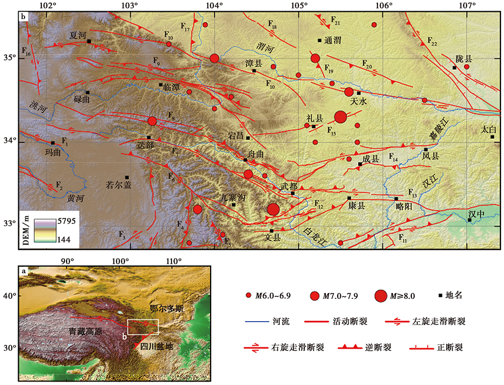
Fig. 1 Regional topography and distribution of active faults and historical earthquakes.
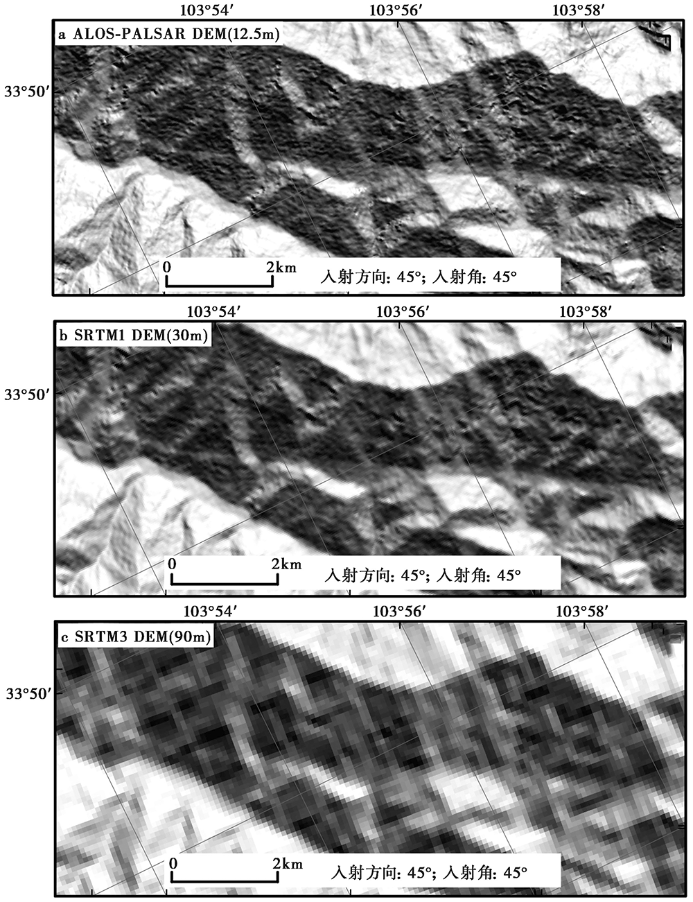
Fig. 2 Comparison of hillshade maps generated from three kinds of medium-resolution DEMs.
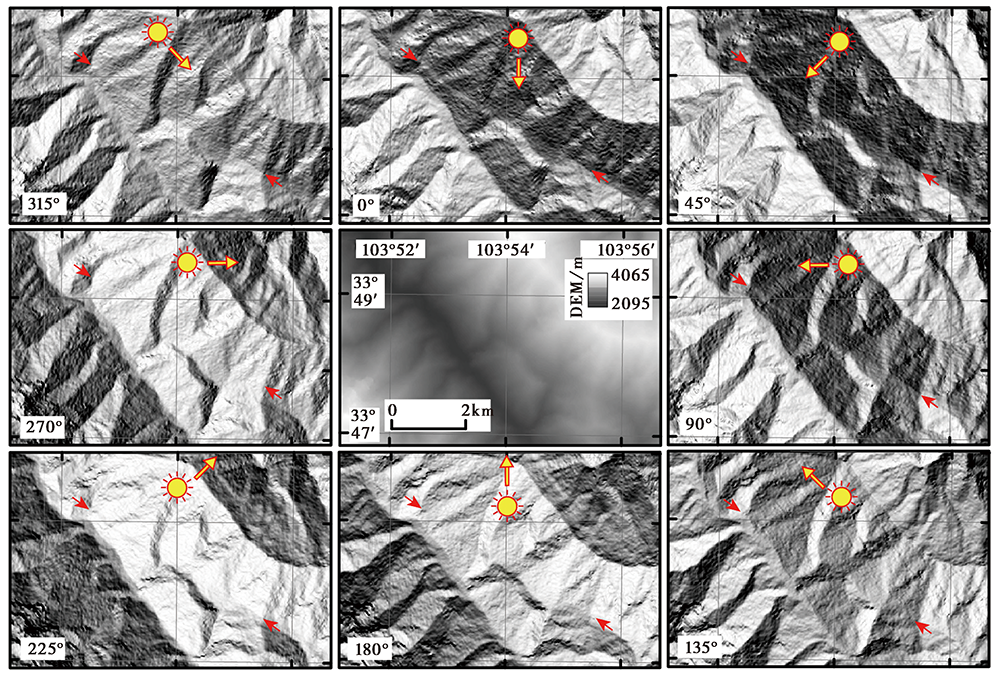
Fig. 3 The relationship between light azimuths and fault lineaments.
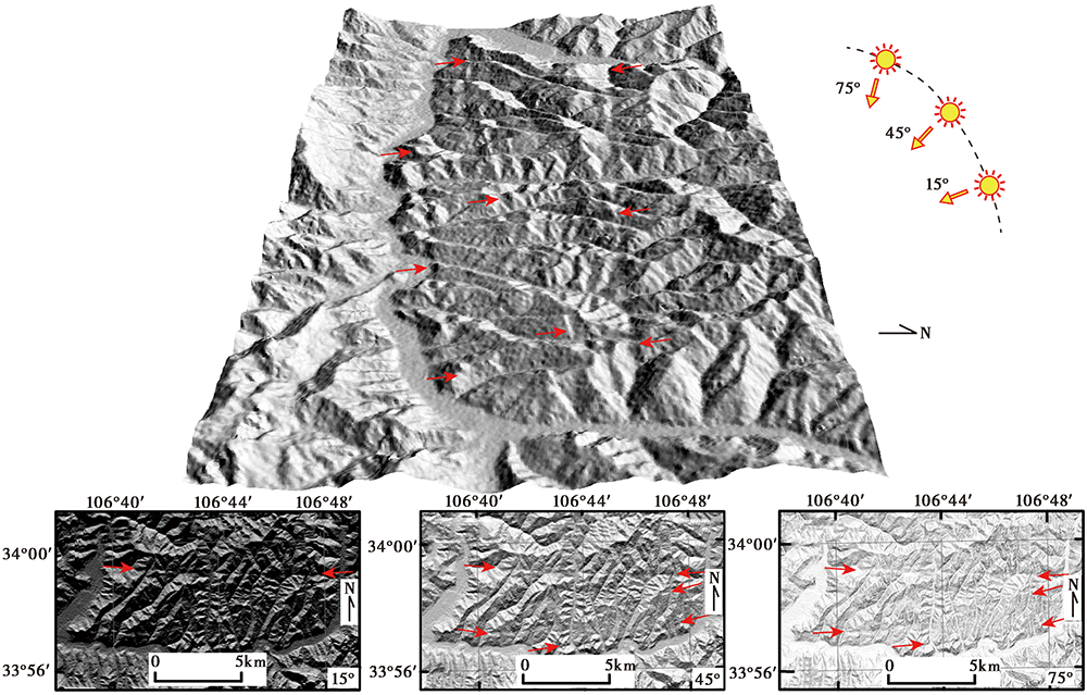
Fig. 4 The relationship between light dip and fault lineaments.
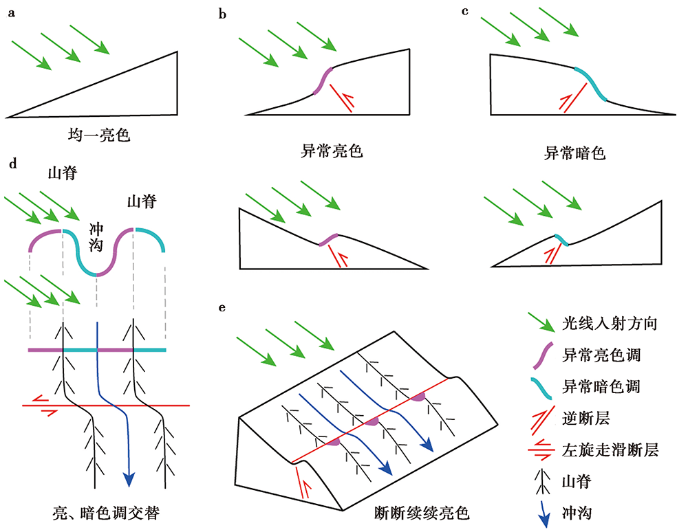
Fig. 5 The principle of unusually bright and dark tones on the hillshade map.
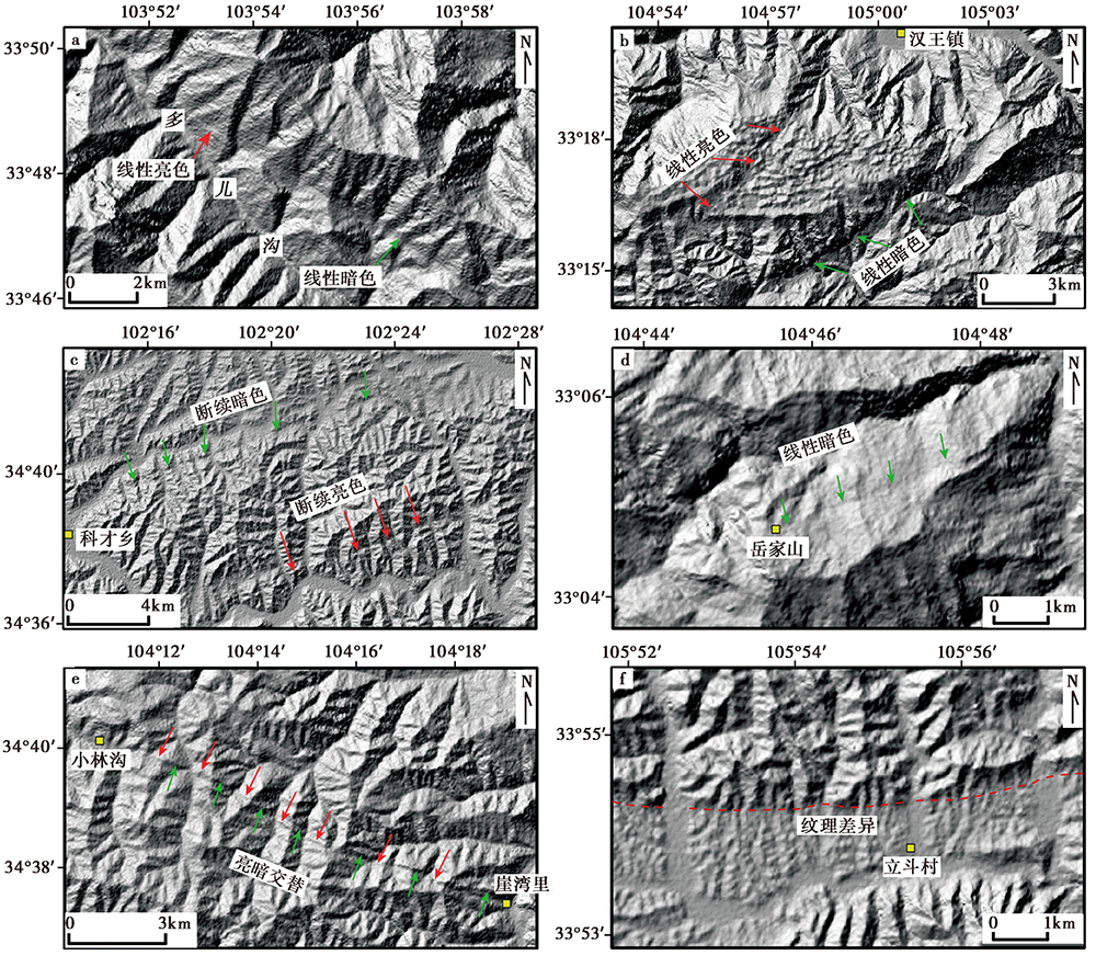
Fig. 6 DEM interpretation markers of the V-shaped fault system in West Qinling.
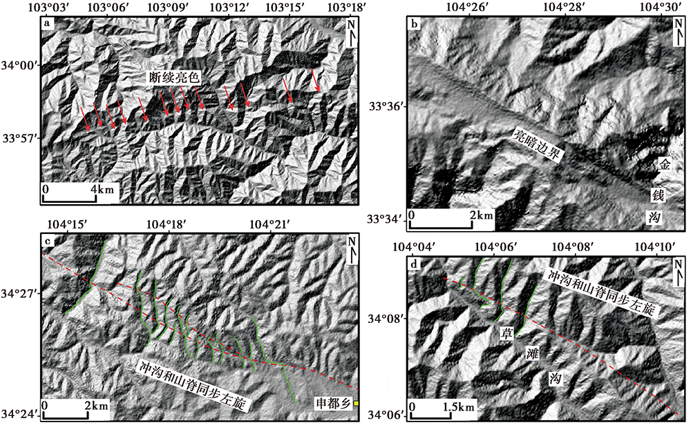
Fig. 7 DEM interpretation markers of the V-shaped fault system in West Qinling.

Fig. 8 Fault lineaments based on ALOS-PALSAR DEM interpretation.
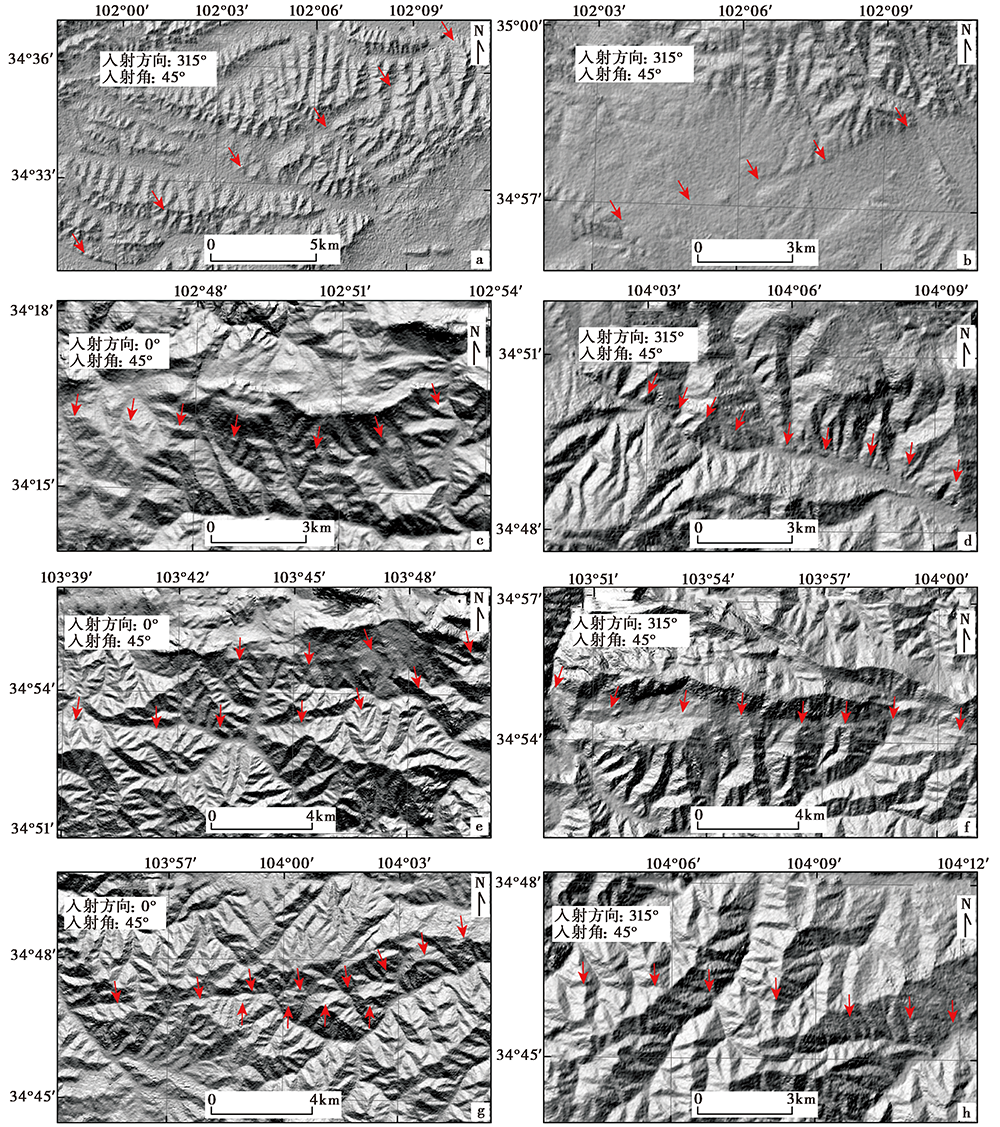
Fig. 9 Fault lineament of NW-trending fault system in West Qinling Mountains.
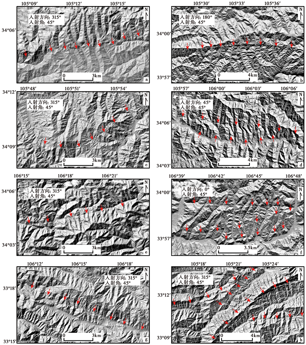
Fig. 10 Fault lineament of the newly-discovered NE-trending fault system in West Qinling Mountains.
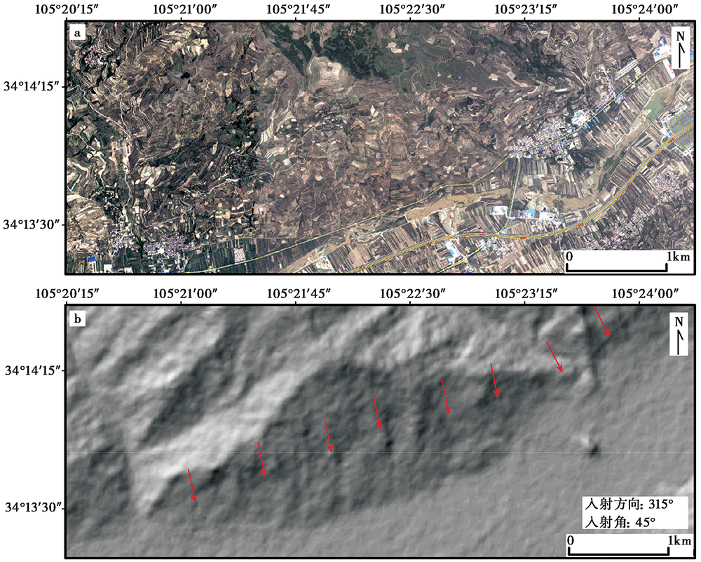
Fig. 11 The faint fault lineament in the Qishan town area of the Lixian-Luojiapu Fault.
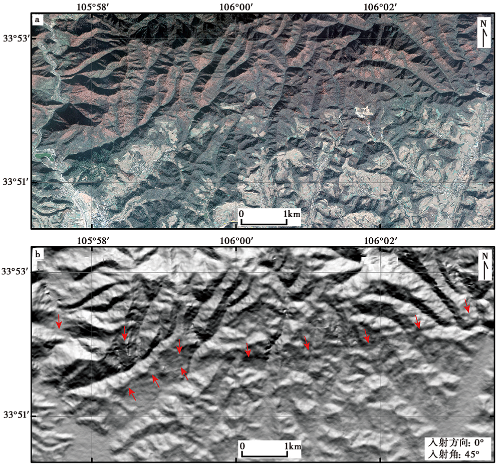
Fig. 12 Fault lineament located between the Maquangou village and Xiajie village along the Liangdang-Jiangluo Fault.
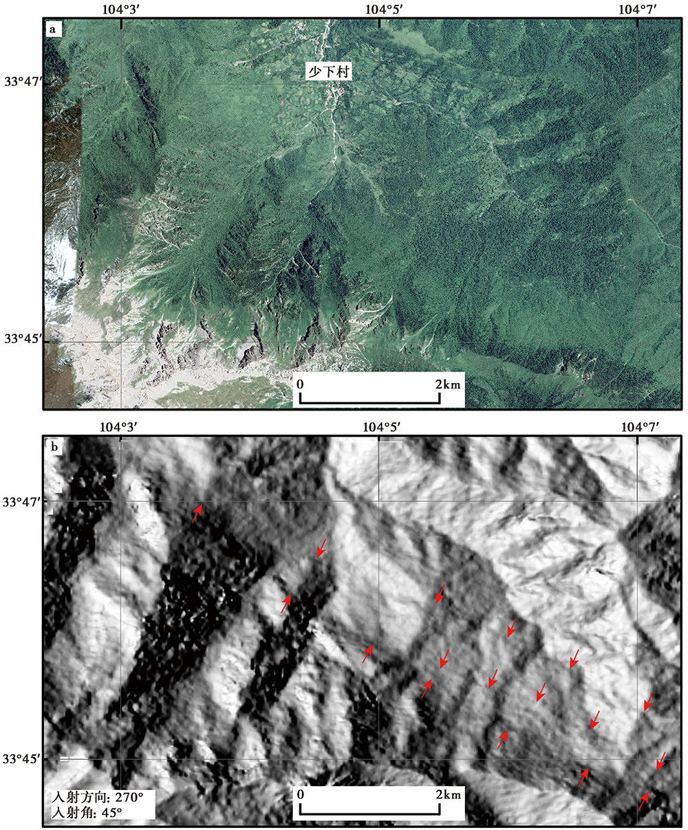
Fig. 13 Fault lineament south of Shaoxia village along the Bailongjiang Fault.
| [1] | 邓起东, 冉勇康, 杨晓平, 等. 2007. 中国活动构造图(1︰400万)[Z]. 北京: 地震出版社. |
| DENG Qi-dong, RAN Yong-kang, YANG Xiao-ping, et al. 2007. Active Tectonics Map of China(1:4 000 000)[Z]. Seismological Press, Beijing. (in Chinese) | |
| [2] | 国家地震局震害防御司. 1995. 中国历史强震目录[M]. 北京: 地震出版社. |
| Department of Earthquake Disaster Prevention, State Seismological Bureau. 1995. Catalogue of Chinese Historical Strong Earthquakes[M]. Seismological Press, Beijing. (in Chinese) | |
| [3] | 韩竹军, 向宏发, 冉勇康. 2001. 青藏高原东缘礼县-罗家堡断裂带晚更新世以来的活动性分析[J]. 地震地质, 23(1): 43-48. |
| HAN Zhu-jun, XIANG Hong-fa, RAN Yong-kang. 2001. Activity analysis of Lixian-Luojiapu fault zone in the east boundary of Tibetan plateau since the late Pleistocene[J]. Seismology and Geology, 23(1): 43-48. (in Chinese) | |
| [4] |
何宏林. 2011. 活动断层填图中的航片解译问题[J]. 地震地质, 33(4): 938-950. doi: 10.3969/j.issn.0253-4967.2011.04.017.
DOI |
| HE Hong-lin. 2011. Some problems of aerial photo interpretation in active fault mapping[J]. Seismology and Geology, 33(4): 938-950. (in Chinese) | |
| [5] | 侯康明, 雷中生, 万夫岭, 等. 2005. 1879年武都南8级大地震及其同震破裂研究[J]. 中国地震, 21(3): 295-310. |
| HOU Kang-ming, LEI Zhong-sheng, WAN Fu-ling, et al. 2005. Research on the 1879 southern Wudu M8.0 earthquake and its coseismic ruptures[J]. Earthquake Research in China, 21(3): 295-310. (in Chinese) | |
| [6] | 贾伟, 刘洪春, 柳煜, 等. 2012. 武都-康县断裂带活动性初步研究[J]. 西北地震学报, 34(2): 142-149. |
| JIA Wei, LIU Hong-chun, LIU Yu, et al. 2012. Preliminary study on activity of the Wudu-Kangxian fault zone[J]. Northwestern Seismological Journal, 34(2): 142-149. (in Chinese) | |
| [7] | 贾伟, 刘洪春, 柳煜, 等. 2018. 武都-康县断裂新活动性的滑动速率[J]. 地震工程学报, 40(4): 794-801. |
| JIA Wei, LIU Hong-chun, LIU Yu, et al. 2018. New activity and slip rate of Wudu-Kangxian Fault[J]. China Earthquake Engineering Journal, 40(4): 794-801. (in Chinese) | |
| [8] | 李光涛, 苏刚, 程理, 等. 2019. 临潭-宕昌断裂带遥感解译及其晚第四纪活动特征研究[J]. 防灾科技学院学报, 21(2): 21-28. |
| LI Guang-tao, SU Gang, CHENG Li, et al. 2019. Remote sensing interpretation of Lintan-Dangchang fault zone and its late Quaternary activity characteristics[J]. Journal of Institute of Disaster Prevention, 21(2): 21-28. (in Chinese) | |
| [9] | 李新男. 2017. 鄂尔多斯西南缘的活动构造几何图像、 运动特征及构造变形模式[D]. 北京: 中国地震局地质研究所. |
| LI Xin-nan. 2017. Geometry, kinematics, and deformation model of the southwestern Ordos[D]. Institute of Geology, China Earthquake Administration, Beijing. (in Chinese) | |
| [10] | 刘兴旺, 袁道阳, 邵延秀, 等. 2015. 甘肃迭部-白龙江南支断裂中东段晚第四纪构造活动特征[J]. 地球科学与环境学报, 37(6): 111-119. |
| LIU Xing-wang, YUAN Dao-yang, SHAO Yan-xiu, et al. 2015. Characteristics of late Quaternary tectonic activity in the middle-eastern segment of the southern branch of Diebu-Bailongjiang Fault, Gansu[J]. Journal of Earth Sciences and Environment, 37(6): 111-119. (in Chinese) | |
| [11] | 马丹, 吴中海, 李家存, 等. 2014. 川西理塘断裂带的空间展布与第四纪左旋走滑活动的遥感影像标志[J]. 地质学报, 88(8): 1417-1435. |
| MA Dan, WU Zhong-hai, LI Jia-cun, et al. 2014. Geometric distribution and the Quaternary activity of Litang active fault zone based on remote sensing[J]. Acta Geologica Sinica, 88(8): 1417-1435. (in Chinese) | |
| [12] | 任俊杰, 徐锡伟, 张世民, 等. 2017. 东昆仑断裂带东端的构造转换与2017年九寨沟 MS7.0 地震孕震机制[J]. 地球物理学报, 60(10): 4027-4045. |
| REN Jun-jie, XU Xi-wei, ZHANG Shi-min, et al. 2017. Tectonic transformation at the eastern termination of the eastern Kunlun fault zone and seismogenic mechanism of the 8 August 2017 Jiuzhaigou MS7.0 earthquake[J]. Chinese Journal of Geophysics, 60(10): 4027-4045. (in Chinese) | |
| [13] | 任治坤, 陈涛, 张会平, 等. 2014. LiDAR技术在活动构造研究中的应用[J]. 地质学报, 88(6): 1196-1207. |
| REN Zhi-kun, CHEN Tao, ZHANG Hui-ping, et al. 2014. LiDAR survey in active tectonic studies: An introduction and overview[J]. Acta Geologica Sinica, 88(6): 1196-1207. (in Chinese) | |
| [14] | 任治坤, 田勤俭, 陈立泽. 2005. 南北地震带中段地震构造遥感解译[J]. 地震, 25(4): 127-132. |
| REN Zhi-kun, TIAN Qin-jian, CHEN Li-ze. 2005. Seismotectonic interpretation along central section of Chinese north-south seismic belt from ETM image[J]. Earthquake, 25(4): 127-132. (in Chinese) | |
| [15] |
邵延秀, 张波, 邹小波, 等. 2017. 采用无人机载LiDAR进行快速地质调查实践[J]. 地震地质, 39(6): 1185-1197. doi: 10.3969/j.issn.0253-4967.2017.06.007.
DOI |
| SHAO Yan-xiu, ZHANG Bo, ZOU Xiao-bo, et al. 2017. Application of UAVLS to rapid geological surveys[J]. Seismology and Geology, 39(6): 1185-1197. (in Chinese) | |
| [16] | 沈强, 乔学军, 王琪, 等. 2013. 多源遥感技术在汶川震后高精度数字高程模型重建中的精度分析[J]. 地球物理学进展, 28(4): 1785-1794. |
| SHEN Qiang, QIAO Xue-jun, WANG Qi, et al. 2013. Analysis of accuracy multi-source remote sensing techniques on high-precision digital elevation model reconstruction after Wenchuan earthquake[J]. Progress in Geophysics, 28(4): 1785-1794. (in Chinese) | |
| [17] | 王爱国, 王金烁, 张波, 等. 2018. 哈南-青山湾-稻畦子断裂活动断层分布图[CM]. 北京: 地震出版社. |
| WANG Ai-guo, WANG Jin-shuo, ZHANG Bo, et al. 2018. Ha’nan-Qingshanwan-Daoqizi Active Fault Map [CM]. Seismological Press, Beijing. (in Chinese) | |
| [18] | 王金烁. 2017. 疑难地震区发震构造研究方法与技术应用: 以甘东南地区为例[D]. 兰州: 中国地震局兰州地震研究所. |
| WANG Jin-shuo. 2017. A study on the research method and technical application of seismogenic structure in difficult earthquake regions: An example in the southeast of Gansu Province[D]. Lanzhou Institute of Seismology, China Earthquake Administration, Lanzhou. (in Chinese) | |
| [19] | 杨晓平, 冯希杰, 黄雄南, 等. 2015. 礼县-罗家堡断裂晚第四纪活动特征: 兼论1654年礼县8级地震孕震机制[J]. 地球物理学报, 58(2): 504-519. |
| YANG Xiao-ping, FENG Xi-jie, HUANG Xiong-nan, et al. 2015. The late Quaternary activity characteristics of the Lixian-Luojiabu Fault: A discussion on the seismogenic mechanism of the Lixian M8 earthquake in 1654[J]. Chinese Journal of Geophysics, 58(2): 504-519. (in Chinese) | |
| [20] | 俞晶星, 郑文俊, 袁道阳, 等. 2012. 西秦岭西段光盖山-迭山断裂带坪定-化马断裂的新活动性与滑动速率[J]. 第四纪研究, 32(5): 957-967. |
| YU Jing-xing, ZHENG Wen-jun, YUAN Dao-yang, et al. 2012. Late Quaternary active characteristics and slip-rate of Pingding-Huama Fault, the eastern segment of Guanggaishan-Dieshan fault zone(west Qinling Mountains)[J]. Quaternary Sciences, 32(5): 957-967. (in Chinese) | |
| [21] | 袁道阳, 张波, 王爱国, 等. 2019. 光盖山-迭山南麓活动断层(1:50 000)[M]. 北京: 地震出版社. |
| YUAN Dao-yang, ZHANG Bo, WANG Ai-guo, et al. 2019. The Southern Guanggaishan-Dieshan Active Fault(1:5 000)[M]. Seismological Press, Beijing. (in Chinese) | |
| [22] | 袁道阳, 张培震, 刘百篪, 等. 2004. 青藏高原东北缘晚第四纪活动构造的几何图像与构造转换[J]. 地质学报, 78(2): 270-278. |
| YUAN Dao-yang, ZHANG Pei-zhen, LIU Bai-chi, et al. 2004. Geometrical imagery and tectonic transformation of late Quaternary active tectonics in northeastern margin of Qinghai-Xizang Plateau[J]. Acta Geologica Sinica, 78(2): 270-278. (in Chinese) | |
| [23] | 张波. 2020. 西秦岭NWW向断裂系的几何图像与变形分配[D]. 北京: 中国地震局地质研究所. |
| ZHANG Bo. 2020. Fault geometry and deformation partition of WNW-trending faults in the West Qinling Mountains[D]. Institute of Geology, China Earthquake Administration, Beijing. (in Chinese) | |
| [24] |
张波, 田勤俭, 王爱国, 等. 2021. 西秦岭临潭-宕昌断裂第四纪最新活动特征[J]. 地震地质, 43(1): 72-91. doi: 10.3969/j.issn.0253-4967.2021.01.005.
DOI |
| ZHANG Bo, TIAN Qin-jian, WANG Ai-guo, et al. 2021. Studies on new activity of Lintan-Dangchang Fault, West Qinling[J]. Seismology and Geology, 43(1): 72-91. (in Chinese) | |
| [25] |
张波, 王爱国, 袁道阳, 等. 2018. 基于多源遥感解译和野外验证的断裂几何展布: 以西秦岭光盖山-迭山南麓断裂为例[J]. 地震地质, 40(5): 1018-1039. doi: 10.3969/j.issn.0253-4967.2018.05.005.
DOI |
| ZHANG Bo, WANG Ai-guo, YUAN Dao-yang, et al. 2018. Fault geometry defined by multiple remote sensing images interpretation and field verification: A case study from southern Guanggaishan-Dieshan Fault, western Qinling[J]. Seismology and Geology, 40(5): 1018-1039. (in Chinese) | |
| [26] | 张波, 王爱国, 袁道阳, 等. 2020. 甘肃夏河断裂新活动的发现: 兼论2019年夏河 MS5.7 地震的发震构造[J]. 地震学报, 42(5): 629-644. |
| ZHANG Bo, WANG Ai-guo, YUAN Dao-yang, et al. 2020. Discovery of new activity of Xiahe Fault in Gansu: Discussion on seismogenic structure of the 2019 Xiahe MS5.7 earthquake[J]. Acta Seismologica Sinica, 42(5): 629-644. (in Chinese) | |
| [27] | 张国伟, 郭安林, 姚安平. 2004. 中国大陆构造中的西秦岭-松潘大陆构造结[J]. 地学前缘, 11(3): 23-32. |
| ZHANG Guo-wei, GUO An-lin, YAO An-ping. 2004. Western Qinling-Songpan continental tectonic node in China’s continental tectonics[J]. Earth Science Frontiers, 11(3): 23-32. (in Chinese) | |
| [28] | 张景发, 姜文亮, 田甜, 等. 2016. 活动断裂调查中的高分辨率遥感技术应用方法研究[J]. 地震学报, 38(3): 386-398. |
| ZHANG Jing-fa, JIANG Wen-liang, TIAN Tian, et al. 2016. High resolution remote sensing application research in active fault surveying[J]. Acta Seismologica Sinica, 38(3): 386-398. (in Chinese) | |
| [29] | 郑文俊, 袁道阳, 何文贵, 等. 2013. 甘肃东南地区构造活动与2013年岷县-漳县 MS6.6 地震孕震机制[J]. 地球物理学报, 56(12): 4058-4071. |
| ZHENG Wen-jun, YUAN Dao-yang, HE Wen-gui, et al. 2013. Geometric pattern and active tectonics in southeastern Gansu Province: Discussion on seismogenic mechanism of the Minxian-Zhangxian MS6.6 earthquake on July 22, 2013[J]. Chinese Journal of Geophysics, 56(12): 4058-4071. (in Chinese) | |
| [30] | 郑文俊, 袁道阳, 张培震, 等. 2016. 青藏高原东北缘活动构造几何图像、 运动转换与高原扩展[J]. 第四纪研究, 36(4): 1-14. |
| ZHENG Wen-jun, YUAN Dao-yang, ZHANG Pei-zhen, et al. 2016. Tectonic geometry and kinematic dissipation of the active faults in the northeastern Tibetan plateau and their implications for understanding northeastward growth of the plateau[J]. Quaternary Sciences, 36(4): 1-14. (in Chinese) | |
| [31] |
邹小波, 袁道阳, 邵延秀, 等. 2017. 采用立体像对和差分GPS揭示民乐-永昌隐伏断裂地表变形特征[J]. 地震地质, 39(6): 1198-1212. doi: 10.3969/j.issn.0253-4967.2017.06.008.
DOI |
| ZOU Xiao-bo, YUAN Dao-yang, SHAO Yan-xiu, et al. 2017. Using stereo-pair and differential GPS to reveal surface deformation characteristics of the Minle-Yongchang Fault[J]. Seismology and Geology, 39(6): 1198-1212. (in Chinese) | |
| [32] |
Das S, Pardeshi S D. 2018. Comparative analysis of lineaments extracted from Cartosat, SRTM and ASTER DEM: A study based on four watersheds in Konkan region, India[J]. Spatial Information Research, 26(1): 47-57.
DOI URL |
| [33] |
Kondo H, Toda S, Okumura K, et al. 2008. A fault scarp in an urban area identified by LiDAR survey: A case study on the Itoigawa-Shizuoka Tectonic Line, central Japan[J]. Geomorphology, 101(4): 731-739.
DOI URL |
| [34] | Li H L, Zhang Y Q, Dong S W, et al. 2020. Neotectonics of the Bailongjiang and Hanan faults: New insights into late Cenozoic deformation along the eastern margin of the Tibetan plateau[J]. GSA Bulletin, 132(9-10): 1-18. |
| [35] |
Lin Z, Kaneda H, Mukoyama S, et al. 2013. Detection of subtle tectonic-geomorphic features in densely forested mountains by very high-resolution airborne LiDAR survey[J]. Geomorphology, 182:104-115.
DOI URL |
| [36] |
Nitheshnirmal S, Thilagaraj P, Rahaman S A, et al. 2019. Erosion risk assessment through morphometric indices for prioritisation of Arjuna watershed using ALOS-PALSAR DEM[J]. Modeling Earth Systems and Environment, 5(3): 907-924.
DOI URL |
| [37] |
Radaideh O M A, Grasemann B, Melichar R, et al. 2016. Detection and analysis of morphotectonic features utilizing satellite remote sensing and GIS: An example in SW Jordan[J]. Geomorphology, 275:58-79.
DOI URL |
| [38] |
Sun H Y, He H L, Ikeda Y, et al. 2015. Holocene paleoearthquake history on the Qingchuan Fault in the northeastern segment of the Longmenshan thrust zone and its implications[J]. Tectonophysics, 660:92-106.
DOI URL |
| [39] |
Zhang B, Wang A G, Yuan D Y, et al. 2021. Slip rates and paleoearthquakes along the east segment of the Guanggaishan-Dieshan fault zone, West Qinling Range, NW China[J]. International Journal of Earth Sciences, 110(1): 213-232.
DOI URL |
| [40] |
Zheng W J, Liu X W, Yu J X, et al. 2016. Geometry and late Pleistocene slip rates of the Liangdang-Jiangluo Fault in the western Qinling Mountains, NW China[J]. Tectonophysics, 687:1-13.
DOI URL |
| [41] |
Zielke O, Arrowsmith J R, Ludwig L G, et al. 2010. Slip in the 1857 and earlier large earthquakes along the Carrizo Plain, San Andreas Fault[J]. Science, 327(5969): 1119-1122.
DOI PMID |
| [1] | ZHANG Ling, MIAO Shu-qing, YANG Xiao-ping. THE ANALYSIS AND IMPLEMENTATION OF THE AUTOMATIC EXTRACTING METHOD FOR ACTIVE THRUST FAULTS IN THE NORTH TIANSHAN MOUNTAINS BASED ON ARCGIS SOFTWARE PLATFORM [J]. SEISMOLOGY AND GEOLOGY, 2023, 45(2): 422-434. |
| Viewed | ||||||
|
Full text |
|
|||||
|
Abstract |
|
|||||
Copyright © SEISMOLOGY AND GEOLOGY, All Rights Reserved.
Tel: 010-62009049/9063 E-mail: dzdz@ies.ac.cn
Powered by Beijing Magtech Co., Ltd.