
SEISMOLOGY AND GEOLOGY ›› 2025, Vol. 47 ›› Issue (5): 1326-1342.DOI: 10.3969/j.issn.0253-4967.2025.05.20250096
Previous Articles Next Articles
ANALYSIS OF CRUSTAL STRUCTURE AND STRONG EARTH-QUAKE ACTIVITY OF THE IRANIAN PLATEAU BASED ON GRAVITY INVERSION IN SPHERICAL COORDINATE SYSTEM
DAI Meng-xue1,2)( ), XU Rong-rong1), ZHAO Fei-yu1,2), PEI Jun-ling1),*()
- 1)National Key Laboratory of Uranium Resources Exploration-Mining and Nuclear Remote Sensing, East China University of Technology, Nanchang 330013, China
2)SinoProbe Laboratory, Chinese Academy of Geological Sciences, Beijing 100094, China
-
Received:2025-04-24Revised:2025-06-18Online:2025-10-20Published:2025-11-11
基于球坐标系重力反演的伊朗高原地壳结构与强震活动分析
戴梦雪1,2)(), 徐荣荣1), 赵斐宇1,2), 裴军令1),*()
- 1)东华理工大学, 铀资源探采与核遥感全国重点实验室, 南昌 330013
2)中国地质科学院, 自然资源部深地科学与探测技术实验室, 北京 100094
-
通讯作者:裴军令, 男, 1977年生, 研究员, 主要从事构造地质研究工作, E-mail:junlingpei@163.com 。 -
作者简介:戴梦雪, 女, 1990年生, 2017年于中国科学院地质与地球物理研究所获固体地球物理学博士学位, 讲师, 主要研究方向为地下深部结构成像, E-mail: daimengxue@ecut.edu.cn。
-
基金资助:国家自然科学基金(42304145); 国家自然科学基金(42430208); 国家重点研发计划项目(2022YFC2807401); 江西省自然科学基金(20232BAB213077); 自然资源部深地科学与探测技术实验室开放课题(SL202412)
Cite this article
DAI Meng-xue, XU Rong-rong, ZHAO Fei-yu, PEI Jun-ling. ANALYSIS OF CRUSTAL STRUCTURE AND STRONG EARTH-QUAKE ACTIVITY OF THE IRANIAN PLATEAU BASED ON GRAVITY INVERSION IN SPHERICAL COORDINATE SYSTEM[J]. SEISMOLOGY AND GEOLOGY, 2025, 47(5): 1326-1342.
戴梦雪, 徐荣荣, 赵斐宇, 裴军令. 基于球坐标系重力反演的伊朗高原地壳结构与强震活动分析[J]. 地震地质, 2025, 47(5): 1326-1342.
share this article
Add to citation manager EndNote|Ris|BibTeX
URL: https://www.dzdz.ac.cn/EN/10.3969/j.issn.0253-4967.2025.05.20250096
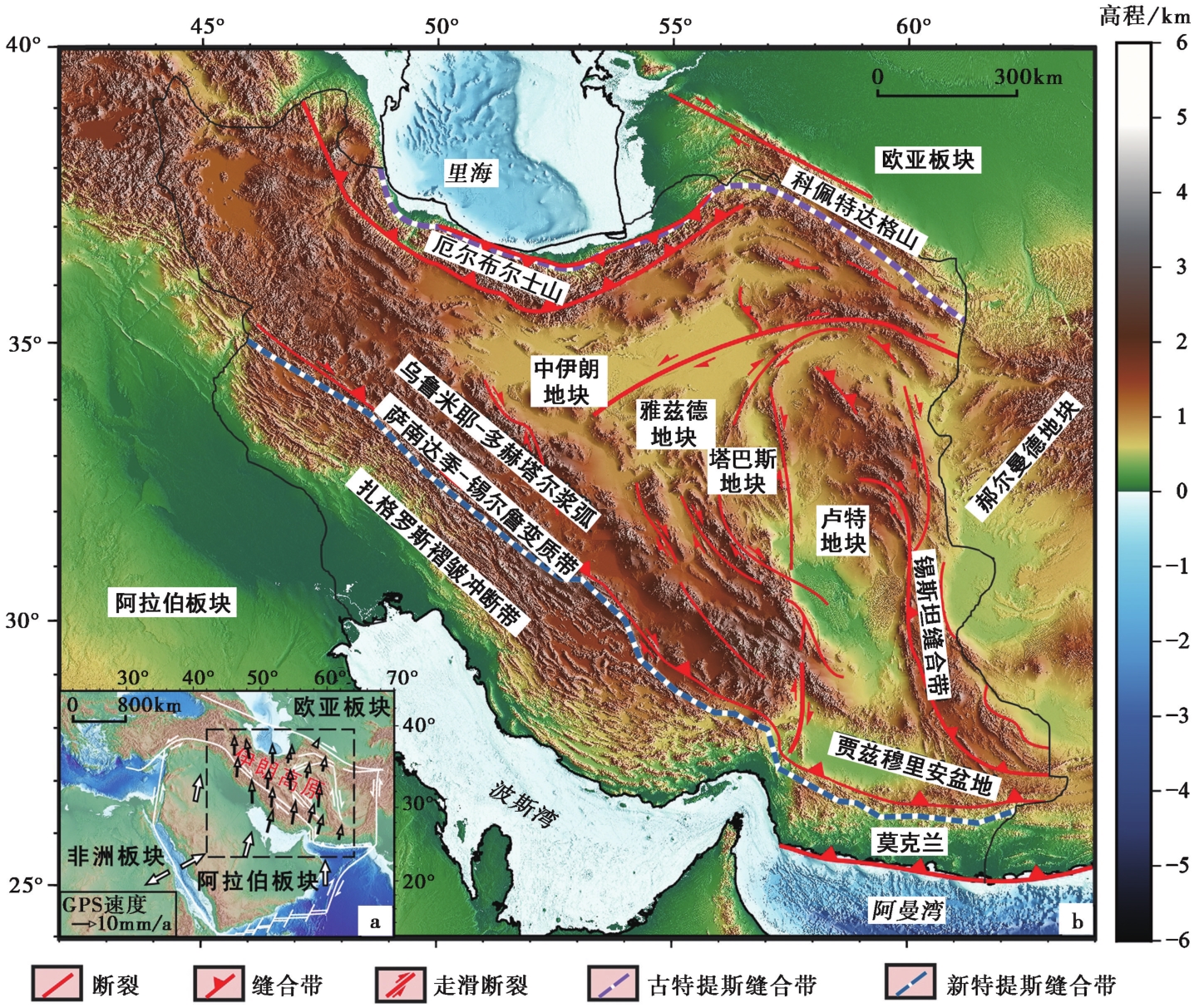
Fig. 1 Background of the Arabia-Eurasia convergence(a) and distribution of the topography and central tectonic units of the Iranian Plateau(b).
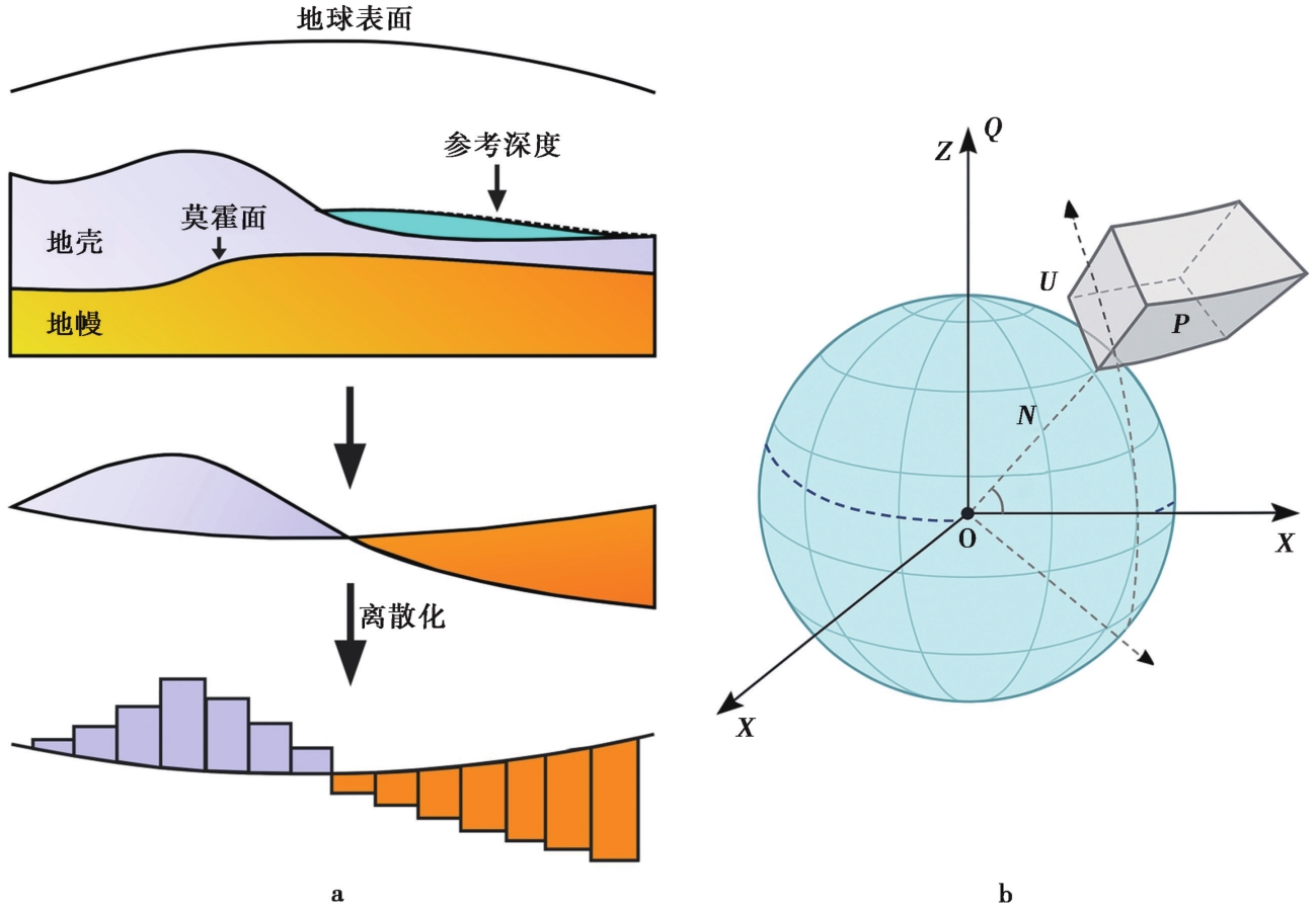
Fig. 2 Schematic diagram of the discretization of the Moho using spherical prisms(a) and a single spherical prism model element in a spherical coordinate system(b).
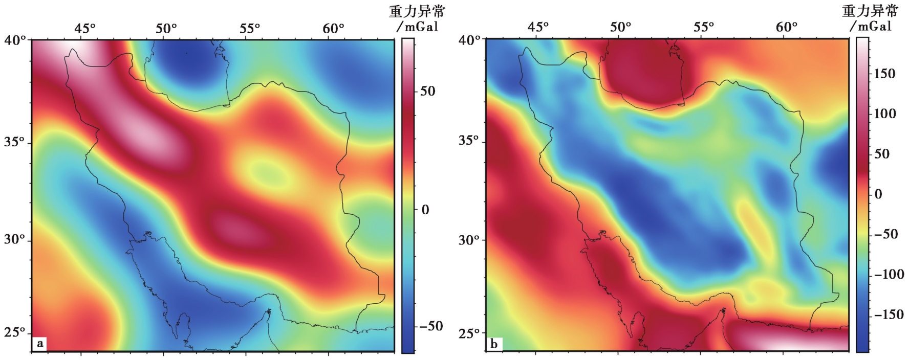
Fig. 3 The original gravity disturbance over the Iranian Plateau(a) and Bouguer gravity anomaly after sedimentary layer correction(b).
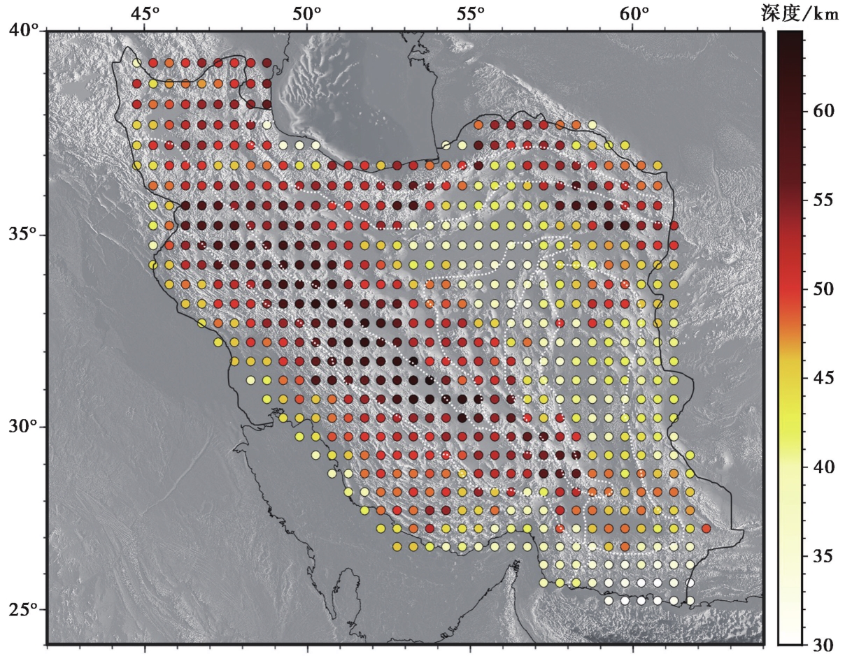
Fig. 4 A priori earthquake constraint dataset on the Iranian Plateau(Moho data adopted from Irandoust et al., 2022).
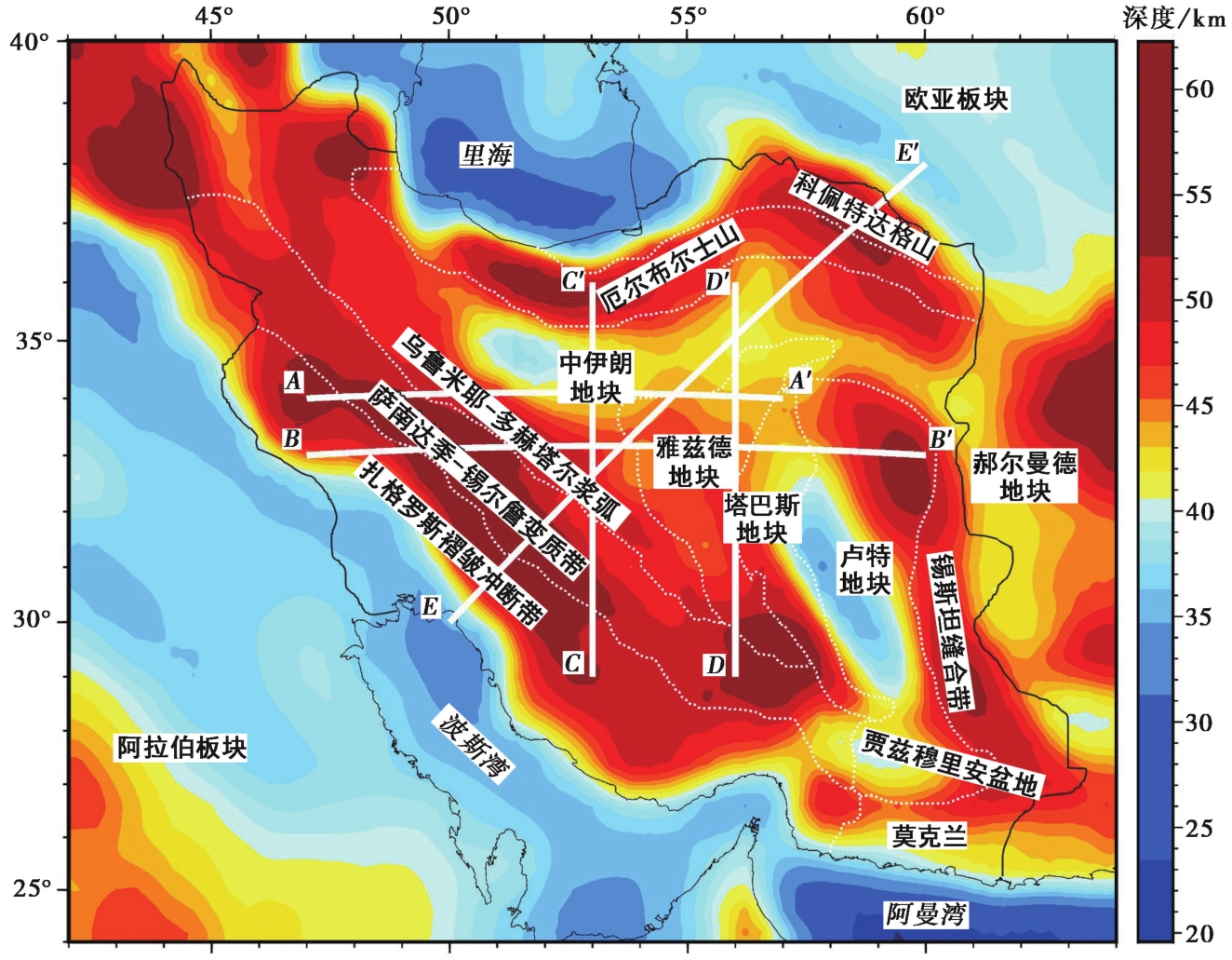
Fig. 5 Moho depth distribution of the Iranian Plateau.
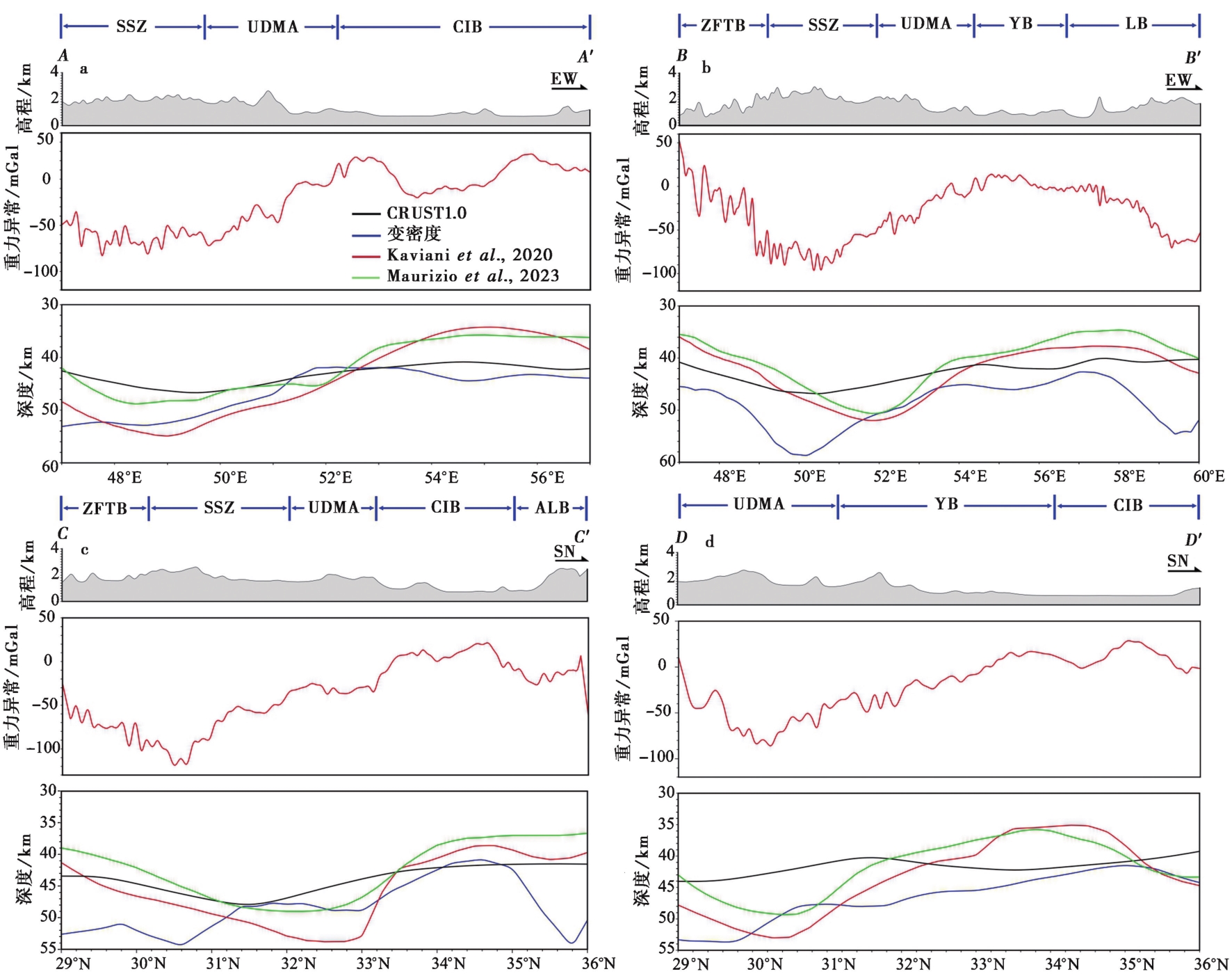
Fig. 6 The comprehensive geophysical profiles along four transects(AA'-DD') across the Iranian Plateau.
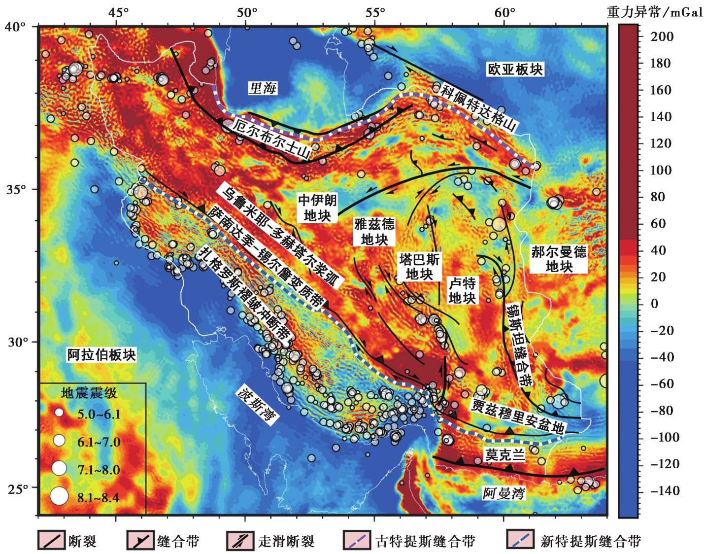
Fig. 7 Equilibrium gravity anomaly and distribution of earthquakes in the Iranian Plateau.
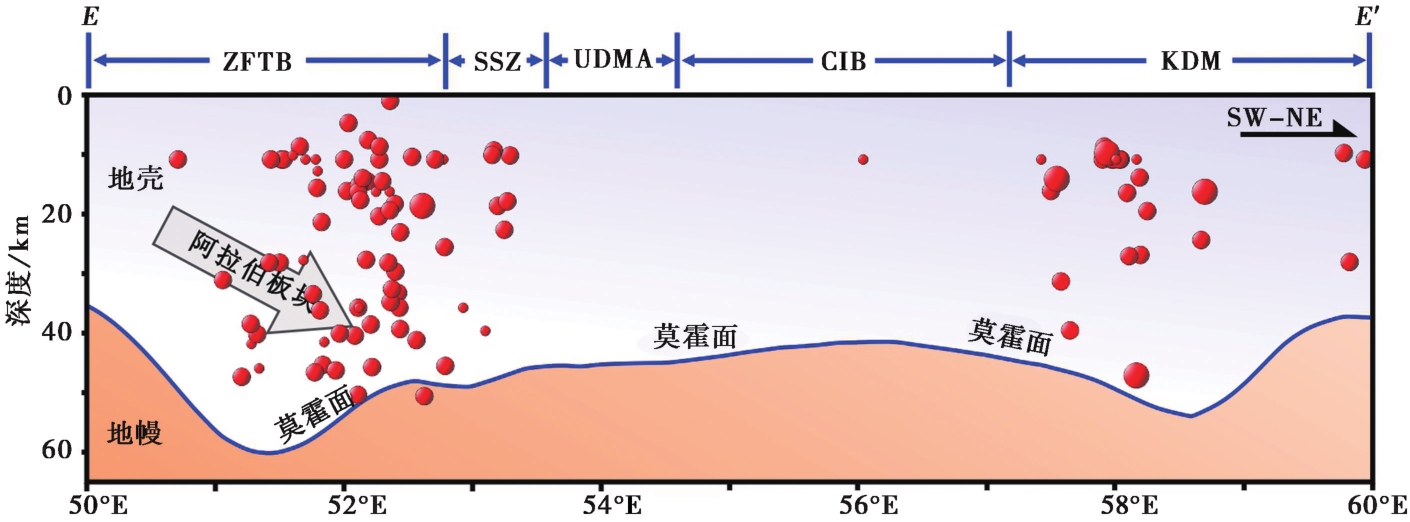
Fig. 8 Crustal structure and strong earthquake distribution of the Iranian Plateau.
| 构造阶段 | 时间 | 构造事件 | 地壳结构响应 | 莫霍面特征 | 代表性区域 |
|---|---|---|---|---|---|
| 第1阶段 | 早二叠世- 晚三叠世 | 古特提斯洋闭合,新特提斯洋裂解 | 地壳拉张减薄 | 莫霍面抬升 | 伊朗中部地块(卢特地块、塔巴斯地块、雅兹德地块) |
| 第2阶段 | 三叠纪- 始新世 | 新特提斯洋俯冲与闭合,陆-陆碰撞开始 | 地壳缩短增厚 | 莫霍面下沉 | 萨南达季-锡尔詹变质带、扎格罗斯前缘 |
| 第3阶段 | 始新世至今 | 阿拉伯-欧亚板块持续碰撞 | 地壳显著增厚、区域差异加大 | 莫霍面西深东浅,四周深中部浅 | 扎格罗斯褶皱冲断带、厄尔布尔士山、科佩特达格山、伊朗中部地块、莫克兰俯冲带 |
Table1 Tectonic evolution stages of the Iranian Plateau and the corresponding crustal structural responses
| 构造阶段 | 时间 | 构造事件 | 地壳结构响应 | 莫霍面特征 | 代表性区域 |
|---|---|---|---|---|---|
| 第1阶段 | 早二叠世- 晚三叠世 | 古特提斯洋闭合,新特提斯洋裂解 | 地壳拉张减薄 | 莫霍面抬升 | 伊朗中部地块(卢特地块、塔巴斯地块、雅兹德地块) |
| 第2阶段 | 三叠纪- 始新世 | 新特提斯洋俯冲与闭合,陆-陆碰撞开始 | 地壳缩短增厚 | 莫霍面下沉 | 萨南达季-锡尔詹变质带、扎格罗斯前缘 |
| 第3阶段 | 始新世至今 | 阿拉伯-欧亚板块持续碰撞 | 地壳显著增厚、区域差异加大 | 莫霍面西深东浅,四周深中部浅 | 扎格罗斯褶皱冲断带、厄尔布尔士山、科佩特达格山、伊朗中部地块、莫克兰俯冲带 |
| [1] |
丁林,
|
|
|
|
| [2] |
付强, 刘天佑, 马龙, 等. 2019. 基于小波变换和均衡重力异常的断裂识别: 以柴达木盆地及周边地区为例[J]. 地震地质, 41(4): 960-978.
|
|
|
|
| [3] |
刘小兵, 温志新, 贺正军, 等. 2019. 中东扎格罗斯盆地: 沿走向变化的构造及油气特征[J]. 岩石学报, 35(4): 1269-1278.
|
|
|
|
| [4] |
邵志刚, 冯蔚, 王芃, 等. 2020. 中国大陆活动地块边界带的地震活动特征研究综述[J]. 地震地质, 42(2): 271-282.
|
|
|
|
| [5] |
万博, 吴福元, 陈凌, 等. 2019. 重力驱动的特提斯单向裂解-聚合动力学[J]. 中国科学(地球科学), 49(12): 2004-2017.
|
|
|
|
| [6] |
王剑, 赵汝敏, 谢楠, 等. 2016. 扎格罗斯前陆盆地构造样式与油气成藏规律[J]. 海洋地质与第四纪地质, 36(2): 143-151.
|
|
|
|
| [7] |
张洪瑞, 侯增谦. 2018. 大陆碰撞带成矿作用: 年轻碰撞造山带对比研究[J]. 中国科学(地球科学), 48(12): 1629-1654.
|
|
|
|
| [8] |
朱日祥, 赵盼, 赵亮. 2022. 新特提斯洋演化与动力过程[J]. 中国科学(地球科学), 52(1): 1-25.
|
|
|
|
| [9] |
|
| [10] |
|
| [11] |
DOI URL |
| [12] |
|
| [13] |
|
| [14] |
|
| [15] |
|
| [16] |
|
| [17] |
|
| [18] |
DOI URL |
| [19] |
DOI URL |
| [20] |
|
| [21] |
|
| [22] |
|
| [23] |
|
| [24] |
|
| [25] |
|
| [26] |
|
| [27] |
|
| [28] |
|
| [29] |
|
| [30] |
|
| [31] |
DOI URL |
| [32] |
DOI URL |
| [33] |
|
| [34] |
DOI URL |
| [35] |
|
| [36] |
|
| [37] |
|
| [38] |
|
| [39] |
|
| [40] |
|
| [41] |
|
| [42] |
|
| [43] |
|
| [44] |
|
| [45] |
|
| [46] |
|
| [47] |
|
| [48] |
|
| [49] |
|
| [50] |
|
| [51] |
|
| [52] |
DOI URL |
| [1] | LIU Yi-jun, YANG Guang-liang, WANG Jia-pei, TAN Hong-bo, ZHOU Huai-bin, SHEN Chong-yang. INVERSION OF INDOSINIAN SURFACE IN CHANGNING, SICHUAN BASED ON PARTICLE SWARM OPTIMIZATION ALGORITHM [J]. SEISMOLOGY AND GEOLOGY, 2023, 45(1): 172-189. |
| [2] | WANG Jian, SHEN Chong-yang, SUN Wen-ke, TAN Hong-bo, HU Min-zhang, LIANG Wei-feng, HAN Yu-fei, ZHANG Xin-lin, WU Gui-ju, WANG Qing-hua. STUDY ON PRESENT GRAVITY CHANGE AND DEEP CRUST DEFORMATION IN THE NORTHERN AND MIDDLE SECTIONS OF THE RED RIVER FAULT ZONE [J]. SEISMOLOGY AND EGOLOGY, 2021, 43(6): 1537-1562. |
| [3] | LI Shi-wen, WENG Ai-hua, TANG Yu, ZHANG Yan-hui, LI Jian-ping, YANG Yue. C-RESPONSE OF GEOMAGNETIC DEPTH SOUNDING ON A 1D THIN SHELL MODEL [J]. SEISMOLOGY AND GEOLOGY, 2018, 40(2): 337-348. |
| [4] | TANG Xin-gong, YOU Shuang-shuang, HU Wen-bao, YAN Liang-jun. THE CRUSTAL DENSITY STRUCTURE UNDERNEATH LONGMENSHAN FAULT ZONE [J]. SEISMOLOGY AND GEOLOGY, 2012, 34(1): 28-38. |
| [5] | Fan Shengming, Yu Qingfan, Lou Hai, Xing Jishan. STUDY OF GKAVITY ANOMALY IN CRUSTAL LOW VELOCITY ZONE IN THE WUTAI REGION [J]. SEISMOLOGY AND GEOLOGY, 1995, 17(2): 109-113. |
| Viewed | ||||||
|
Full text |
|
|||||
|
Abstract |
|
|||||
Copyright © SEISMOLOGY AND GEOLOGY, All Rights Reserved.
Tel: 010-62009049/9063 E-mail: dzdz@ies.ac.cn
Powered by Beijing Magtech Co., Ltd.