
SEISMOLOGY AND GEOLOGY ›› 2026, Vol. 48 ›› Issue (3): 830-852.DOI: 10.3969/j.issn.0253-4967.20240123
• Research paper • Previous Articles Next Articles
THREE DIMENSIONAL S-WAVE VELOCITY STRUCTURE AND SEISMICITY CHARACTERISTICS IN THE RONGXIAN-WEIYUAN-ZIZHONG AREA OF SOUTHERN SICHUAN
JIANG Ning-bo1,2)( ), LI Da-hu1,2),*(), ZUO Hong1,2), WANG Chao-liang3), GAO Mi1,2), YI Gui-xi1,3), CHEN Xue-fen1,2)
- 1)
Sichuan Earthquake Agency
2)Chengdu Institute of the Tibetan plateau Earthquake Research ,China Earthquake Administration
3)Chengdu University of Technology
-
Received:2025-02-15Revised:2025-04-26Online:2026-06-20Published:2026-07-09
川南荣县—威远—资中地区三维S波速度结构与地震活动特征
江宁波1,2)(), 李大虎1,2),*(), 左洪1,2), 王朝亮3), 高咪1,2), 易桂喜1,3), 陈学芬1,2)
- 1)
四川省地震局
2)中国地震局成都青藏高原地震研究所(中国地震科学实验场成都基地)
3)成都理工大学
-
通讯作者:*李大虎, 男, 1982年生, 博士, 研究员, 目前主要从事地震学、密集台阵观测和深部孕震环境研究等工作, E-mail: lixiang2006@sina.com。 -
作者简介:江宁波, 男, 1996年生, 2021年于成都理工大学获地球物理学硕士学位, 主要从事地震学应用等方面的研究, E-mail: Jiangnb2016@foxmail.com。
-
基金资助:中国地震局地震科技星火计划项目(XH23032YA); 地震动力学国家重点实验室开放基金(LED2023B06); 国家重点研发计划项目(2020YFA0710603-02); 四川省地震局地震科技创新团队(202302)

Cite this article
JIANG Ning-bo, LI Da-hu, ZUO Hong, WANG Chao-liang, GAO Mi, YI Gui-xi, CHEN Xue-fen. THREE DIMENSIONAL S-WAVE VELOCITY STRUCTURE AND SEISMICITY CHARACTERISTICS IN THE RONGXIAN-WEIYUAN-ZIZHONG AREA OF SOUTHERN SICHUAN[J]. SEISMOLOGY AND GEOLOGY, 2026, 48(3): 830-852.
江宁波, 李大虎, 左洪, 王朝亮, 高咪, 易桂喜, 陈学芬. 川南荣县—威远—资中地区三维S波速度结构与地震活动特征[J]. 地震地质, 2026, 48(3): 830-852.
share this article
Add to citation manager EndNote|Ris|BibTeX
URL: https://www.dzdz.ac.cn/EN/10.3969/j.issn.0253-4967.20240123

Fig. 1 Map of the geological structure and historical earthquake distribution in the Rongxian-Weiyuan-Zizhong region(modified from Liu et al., 2023).
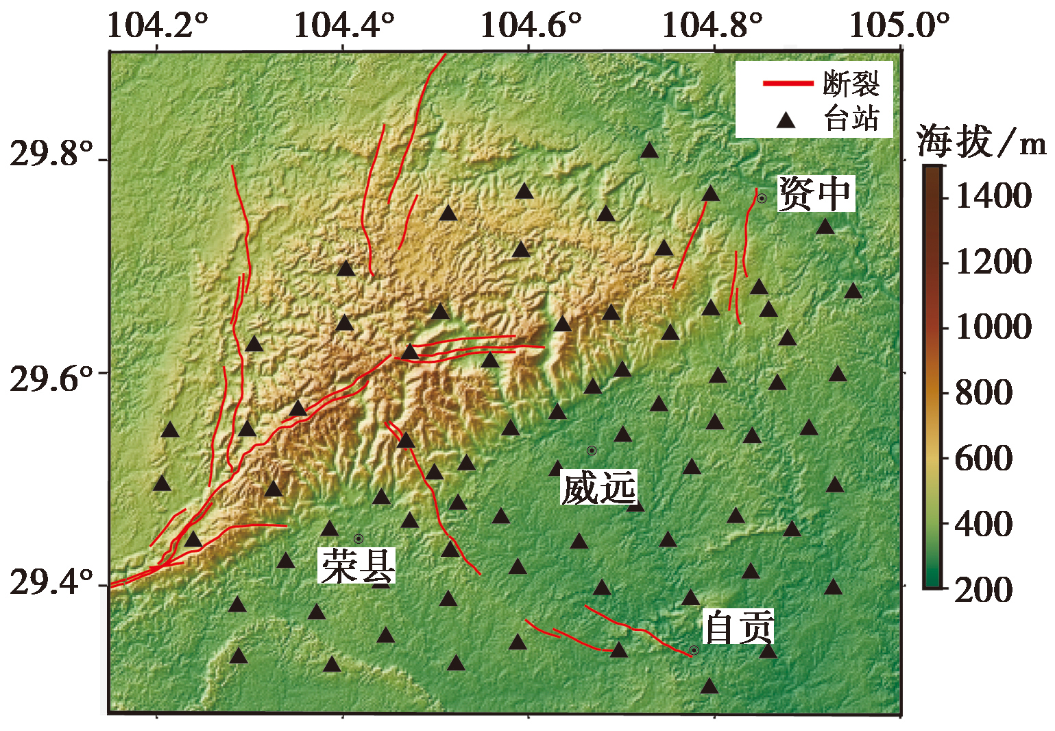
Fig. 2 Schematic diagram of dense array layout.
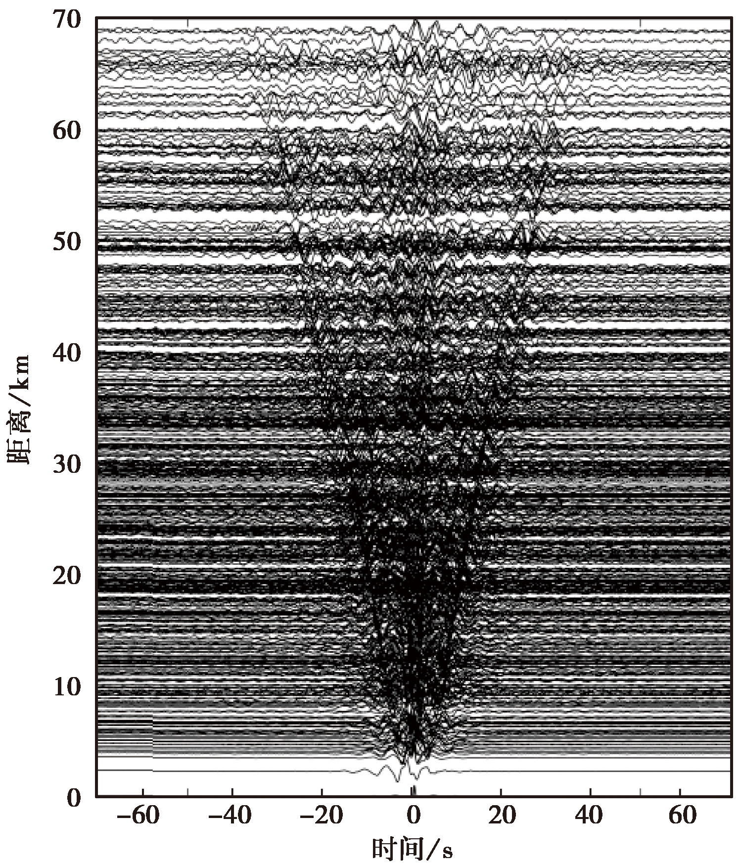
Fig. 3 Cross-correlation waveform diagram.
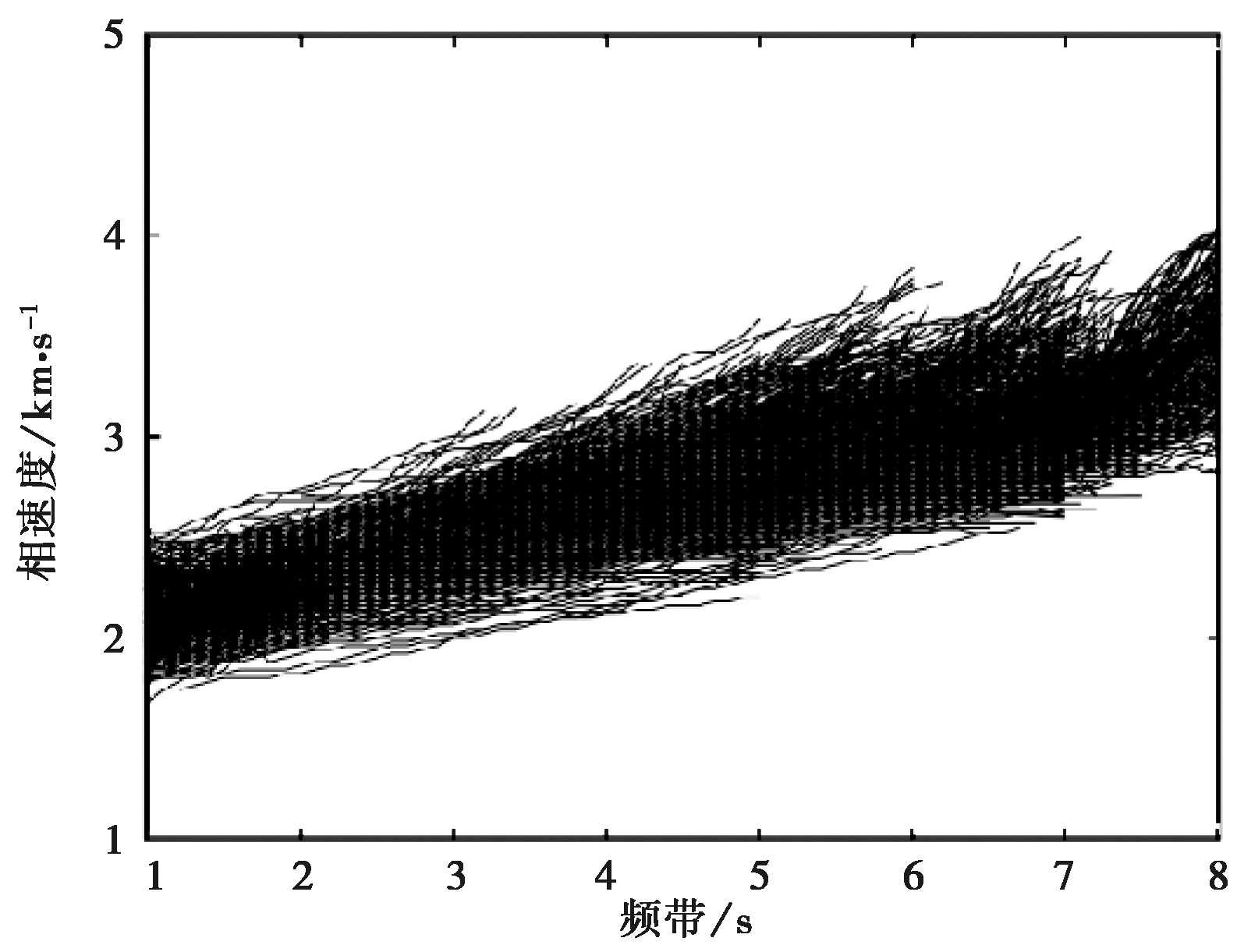
Fig. 4 Some Rayleigh wave phase velocity dispersion curves.
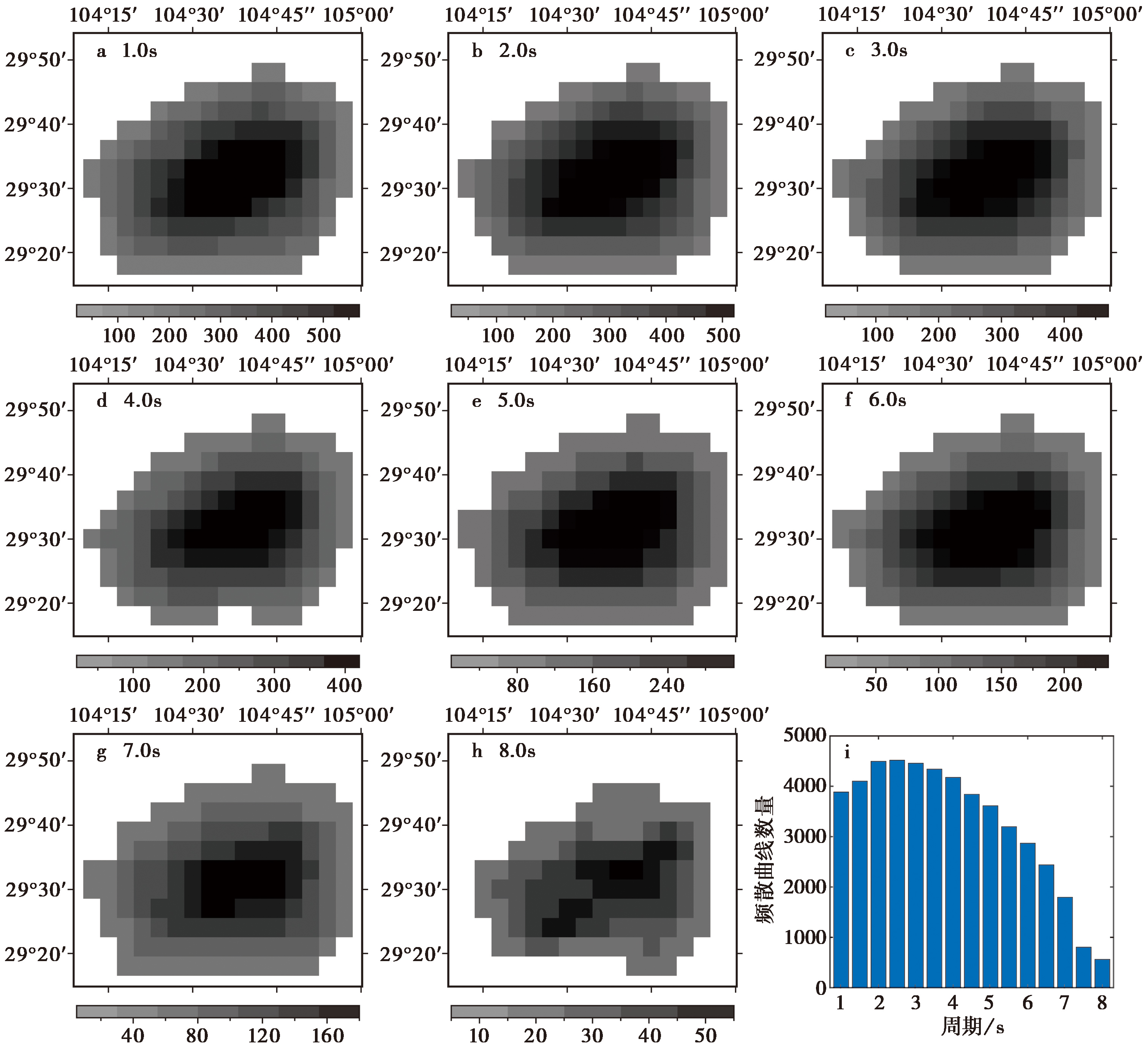
Fig. 5 Ray path coverage and the number of dispersion data at different period.
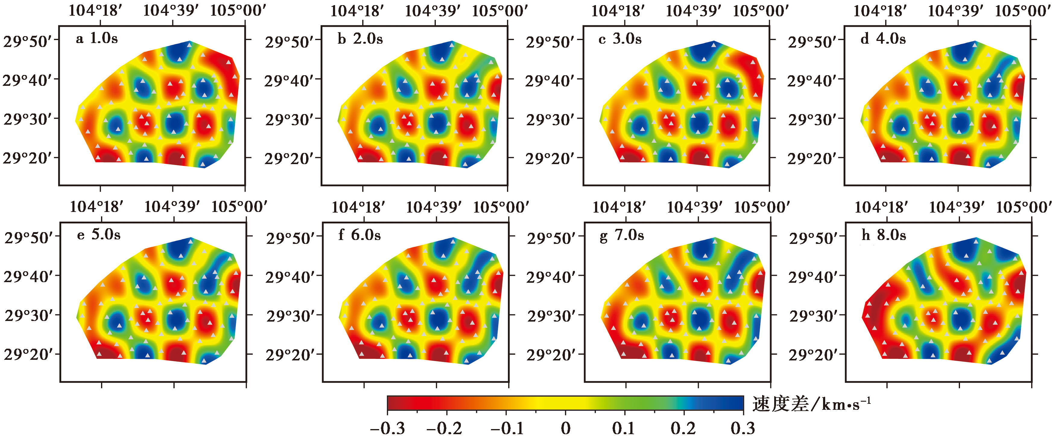
Fig. 6 The checkboard test results at different period.

Fig. 7 The phase velocity distribution at different period(unit: km/s).
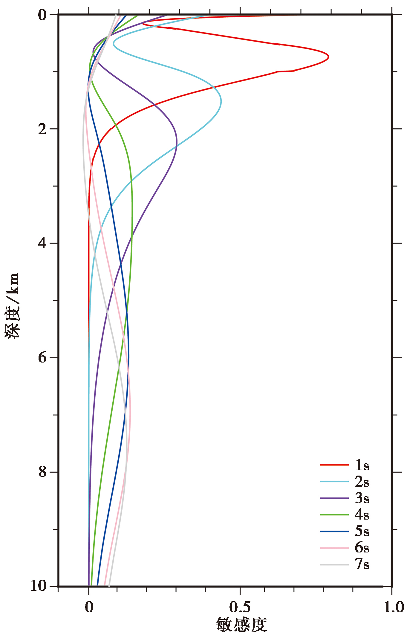
Fig. 8 Depth sensitivity kernel curves.

Fig. 9 The S wave velocity distribution at different depth(unit: km/s).
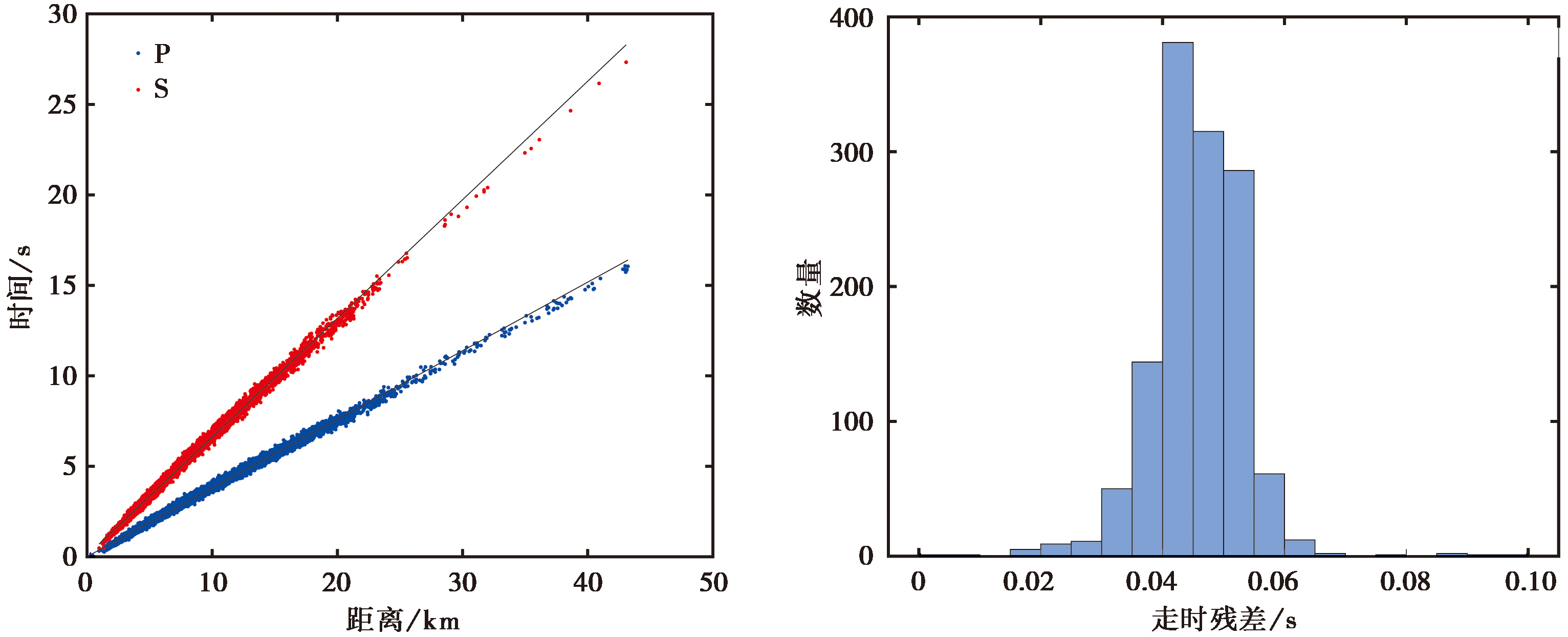
Fig. 10 P and S wave travel time curves and arrival time residuals.
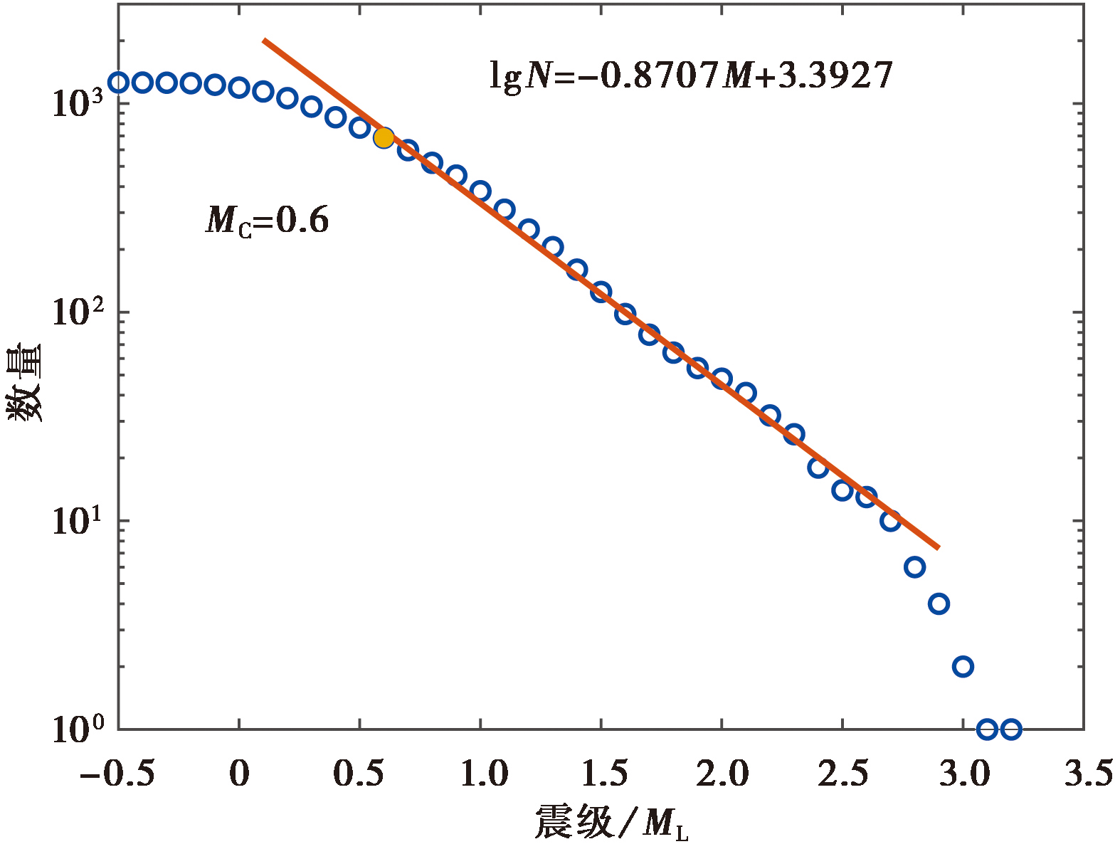
Fig. 11 Earthquake magnitude distribution and b-value fitting results.

Fig. 12 Earthquake catalog of this study(blue)(a), the network observation(red)(b), and comparison of depth distribution(c).
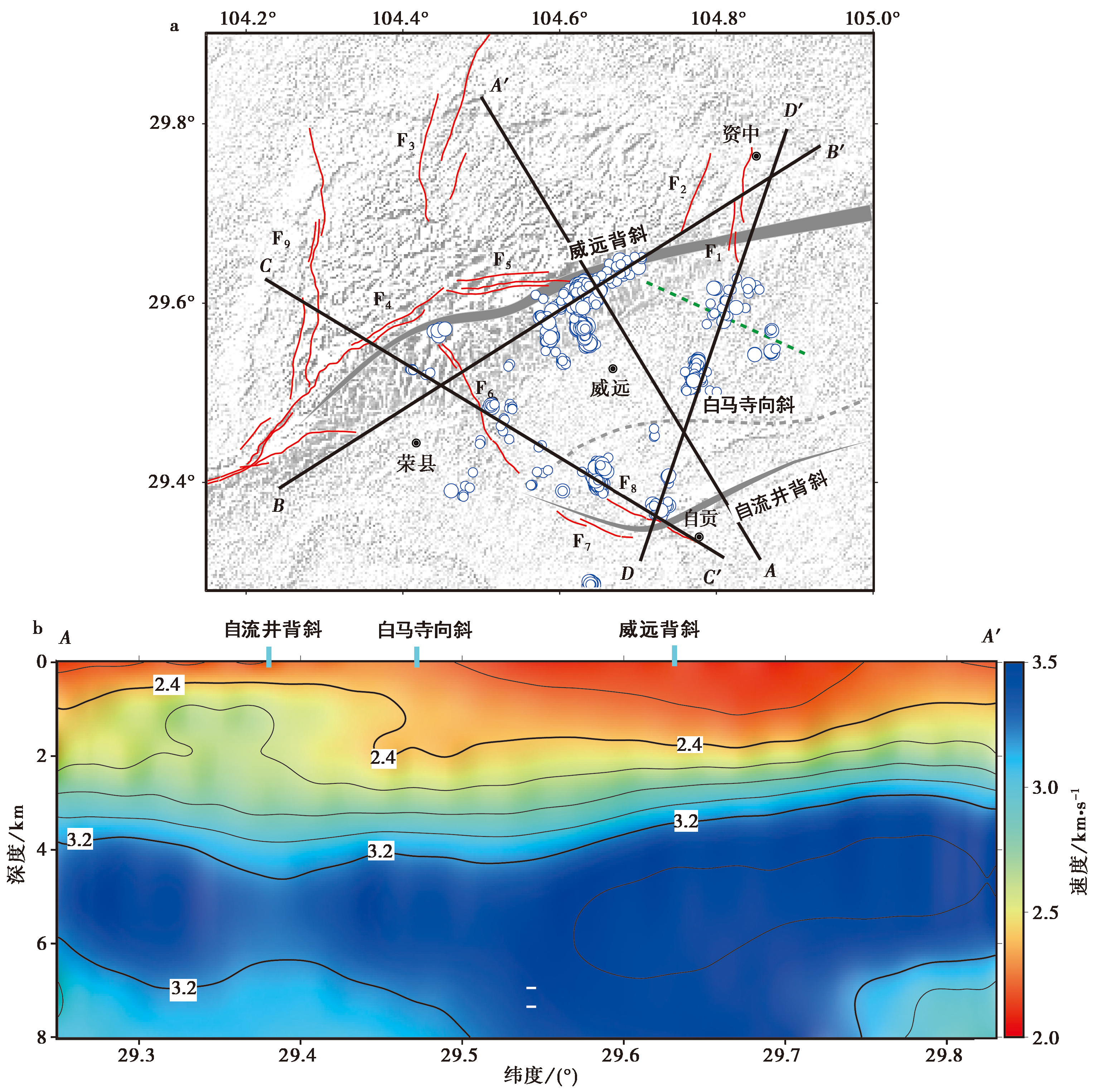
Fig. 13 Velocity profile along AA' line.

Fig. 14 The projection distribution of earthquakes on the velocity profile.
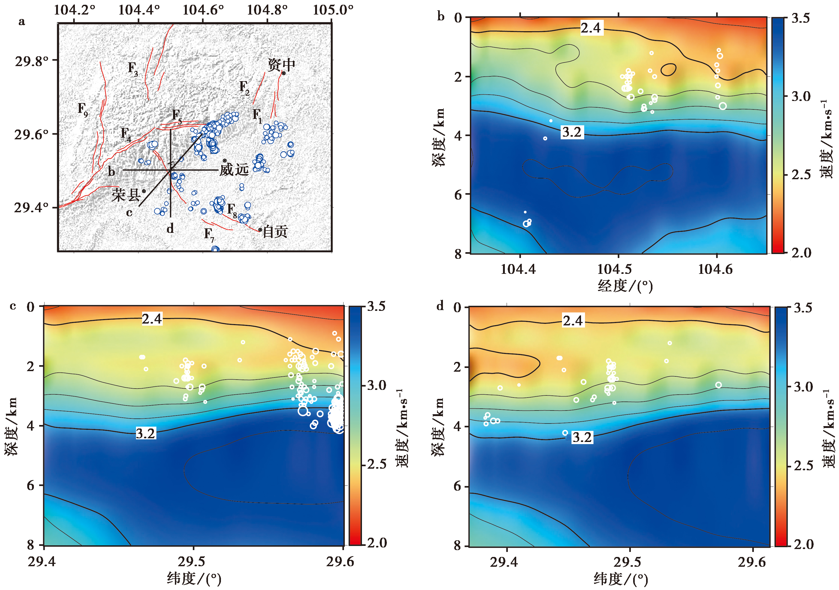
Fig. 15 Velocity structure profile for the epicentral region of M4.0+ earthquakes in Rongxian in 2019.
| [1] |
杜广宝, 吴庆举, 张雪梅, 等. 2021. 四川威远及邻区中小地震活动特征及地壳精细结构研究[J]. 地球物理学报, 64(11): 3983-3996.
DOI |
|
|
|
| [2] |
高金尉. 2012. 四川盆地西南地区构造几何学与运动学特征及其对青藏高原东南缘动力学背景的指示[D]. 北京: 中国地质大学(北京).
|
|
|
|
| [3] |
高原, 石玉涛, 陈安国. 2018. 青藏高原东缘地震各向异性、应力及汶川地震影响[J]. 科学通报, 63(19): 1934-1948.
|
|
|
|
| [4] |
高原, 石玉涛, 王琼. 2020. 青藏高原东南缘地震各向异性及其深部构造意义[J]. 地球物理学报, 63(3): 802-816.
DOI |
|
|
|
| [5] |
顾勤平, 康清清, 张鹏, 等. 2020. 郯庐断裂带中南段及邻区Rayleigh波相速度与方位各向异性[J]. 地震地质, 42(5): 1129-1152. doi: 10.3969/j.issn.0253-4967.2020.05.007.
|
|
DOI |
|
| [6] |
谷志东, 闫淑玉, 张波, 等. 2012. 川中威远低缓隆起区三叠系地层中的构造解耦记录及其构造暗示[J]. 北京大学学报(自然科学版), 48(2): 262-272.
|
|
|
|
| [7] |
郭颖星, 朱涛. 2022. 四川威远-荣县工业开采区地壳电性结构研究[J]. 地球物理学报, 65(9): 3451-3463.
|
|
|
|
| [8] |
花茜, 梁春涛, 杨宜海, 等. 2020. 基于模拟退火法的青藏高原东缘噪声层析成像研究[J]. 地球物理学报, 63(5): 1787-1801.
DOI |
|
|
|
| [9] |
李大虎, 詹艳, 丁志峰, 等. 2021. 四川长宁 MS6.0 地震震区上地壳速度结构特征与孕震环境[J]. 地球物理学报, 64(1): 18-35.
DOI |
|
|
|
| [10] |
王小龙, 马胜利, 雷兴林, 等. 2012. 重庆荣昌诱发地震区精细速度结构及2010年ML5.1地震序列精确定位[J]. 地震地质, 34(2): 348-358. doi: 10.3969/j.issn.0253-4967.2012.02.013.
|
|
DOI |
|
| [11] |
王赞军, 王宏超, 董娣, 等. 2018. 华蓥山断裂带的物探成果综述[J]. 四川地震, (3): 6-12.
|
|
|
|
| [12] |
吴萍萍, 李大虎, 詹艳, 等. 2023. 2021年9月16日四川泸县 MS6.0 地震震区三维S波精细速度结构[J]. 地球物理学报, 66(6): 2386-2403.
|
|
|
|
| [13] |
谢辉, 马禾青, 焦明若, 等. 2017. 利用背景噪声成像技术反演宁夏及邻区S波速度结构[J]. 地震地质, 39(3): 605-622. doi: 10.3969/j.issn.0253-4967.2017.03.012.
|
|
DOI |
|
| [14] |
徐世荣, 徐锦华. 1986. 华蓥山断裂带地震勘探新成果[J]. 石油学报, 7(3): 39-48.
DOI |
|
DOI |
|
| [15] |
徐涛, 张明辉, 田小波, 等. 2014. 丽江-清镇剖面上地壳速度结构及其与鲁甸 MS6.5 地震孕震环境的关系[J]. 地球物理学报, 57(9): 3069-3079.
DOI |
|
|
|
| [16] |
徐微, 丁志峰, 吴萍萍, 等. 2022. 利用密集台阵背景噪声研究通州-三河地区高分辨率三维S波速度结构[J]. 地球物理学报, 65(12): 4685-4703.
|
|
|
|
| [17] |
易桂喜, 龙锋, 梁明剑, 等. 2019. 2019年6月17日四川长宁 MS6.0 地震序列震源机制解与发震构造分析[J]. 地球物理学报, 62(9): 3432-3447.
DOI |
|
|
|
| [18] |
易桂喜, 龙锋, 梁明剑, 等. 2020. 四川盆地荣县-威远-资中地区发震构造几何结构与构造变形特征: 基于震源机制解的认识和启示[J]. 地球物理学报, 63(9): 3275-3291.
DOI |
|
|
|
| [19] |
易桂喜, 赵敏, 龙锋, 等. 2021. 2021年9月16日四川泸县 MS6.0 地震序列特征及孕震构造环境[J]. 地球物理学报, 64(12): 4449-4461.
DOI |
|
|
|
| [20] |
曾求, 储日升, 盛敏汉, 等. 2020. 基于地震背景噪声的四川威远地区浅层速度结构成像研究[J]. 地球物理学报, 63(3): 944-955.
DOI |
|
|
|
| [21] |
张岳桥, 董树文, 李建华, 等. 2011. 中生代多向挤压构造作用与四川盆地的形成和改造[J]. 中国地质, 38(2): 233-250.
|
|
|
|
| [22] |
|
| [23] |
|
| [24] |
|
| [25] |
DOI |
| [26] |
|
| [27] |
DOI URL |
| [28] |
|
| [29] |
|
| [30] |
|
| [31] |
|
| [32] |
DOI |
| [33] |
|
| [34] |
|
| [35] |
DOI URL |
| [36] |
|
| [37] |
|
| [38] |
|
| [39] |
|
| [40] |
|
| [41] |
DOI URL |
| [42] |
|
| [43] |
|
| [44] |
|
| [45] |
|
| [46] |
|
| [47] |
DOI URL |
| [48] |
DOI |
| [49] |
|
| [50] |
|
| [1] | WANG Xin, GAO Min, QIAO Ji-hua, XIANG Jian-bin, XU Yu-chen, FAN Ji-di. GRAVITY ISOSTASY AND DEEP SEISMOGENIC ENVIRONMENT IN THE MIDDLE SEGMENT OF THE TANLU FAULT ZONE [J]. SEISMOLOGY AND GEOLOGY, 2026, 48(3): 741-756. |
| [2] | ZHANG Tian-ji, QIN Min, DANG Wen-jie, JIN Ming-pei, LI Feng-ying, YANG Li-wei. THE S-WAVE VELOCITY STRUCTURE OF THE TENGCHONG-BAOSHAN REGION FROM JOINT INVERSION OF RECEIVER FUNCTION AND RAYLEIGH WAVE PHASE VELOCITY [J]. SEISMOLOGY AND GEOLOGY, 2025, 47(5): 1364-1381. |
| [3] | YANG Jian-wen, JIN Ming-pei, YE Beng, CHA Wen-jian, HEI He-tang. THREE-DIMENSIONAL VELOCITY STRUCTURE AND SEI-SMOGENIC ENVIRONMENT IN THE MIDDLE AND UPPER CRUST OF NORTHWEST YUNNAN FROM AMBIENT NOISE TOMOGRAPHY [J]. SEISMOLOGY AND GEOLOGY, 2025, 47(4): 1113-1131. |
| [4] | LI Ruo-hao, LEI Jian-she, SONG Xiao-yan. 3-D CRUSTAL S-WAVE VELOCITY STRUCTURE IN AND AROUND THE DATONG VOLCANIC GROUP: CONSTRAINTS FROM DIRECT TOMOGRAPHIC IMAGING OF AMBIENT-NOISE SURFACE WAVES [J]. SEISMOLOGY AND GEOLOGY, 2025, 47(4): 1090-1112. |
| [5] | JI Yu, ZHANG Guang-wei, REN Jun-jie, HE Jing, WANG Xiao-wei. HIGH-RESOLUTION S-WAVE VELOCITY STRUCTURE OF BEIJING AREA USING AMBIENT NOISE TOMOGRAPHY [J]. SEISMOLOGY AND GEOLOGY, 2025, 47(1): 306-324. |
| [6] | FENG Ce, SONG Xiu-qing, WANG Ren-tao, LIU Hao-lan. S-WAVE VELOCITY STRUCTURE IN SHANGHAI AND ADJACENT AREAS BASED ON AMBIENT NOISE TOMOGRAPHY [J]. SEISMOLOGY AND GEOLOGY, 2024, 46(6): 1374-1390. |
| [7] | LIU Wen-yu, CHENG Zheng-pu, NIAN Xiu-qing, CHEN Yan, HU Yu-ling, QIN Zu-jian, SHAO Ming-zheng. GENESIS OF SONGYUAN EARTHQUAKES BASED ON 3D RESIDUAL DENSITY STRUCTURE [J]. SEISMOLOGY AND GEOLOGY, 2024, 46(2): 462-476. |
| [8] | FANG Dong, HU Min-zhang, HAO Hong-tao. MULTI-SCALE ANALYSIS OF THE GRAVITY FIELD IN THE SOUTHEASTERN QINGHAI-TIBET PLATEAU AND ITS TECTONIC IMPLICATIONS [J]. SEISMOLOGY AND EGOLOGY, 2021, 43(5): 1208-1232. |
| [9] | KONG Xiang-yan, WU Jian-ping, FANG Li-hua, CAI Yan, FAN Li-ping, WANG Wei-lai. JOINT INVERSION OF SURFACE WAVE DISPERSION AND RECEIVER FUNCTIONS FOR CRUSTAL AND UPPERMOST MANTLE STRUCTURE BENEATH CHINESE TIENSHAN AND ITS ADJACENT AREAS [J]. SEISMOLOGY AND GEOLOGY, 2020, 42(4): 844-865. |
| [10] | SUN Xiang-yu, ZHAN Yan, ZHAO Ling-qiang, CHEN Xiao-bin, LI Chen-xia, SUN Jian-bao, HAN Jing, CUI Teng-fa. ELECTRICAL STRUCTURE OF THE 2017 MS7.0 JIUZHAIGOU EARTHQUAKE REGION AND THE EASTERN TERMINUS OF THE EAST KUNLUN FAULT [J]. SEISMOLOGY AND GEOLOGY, 2020, 42(1): 182-197. |
| [11] | FENG Hong-wu, YAN Wen-hua, YAN Shan, GUO Ying-xia, HUI Shao-xing, CHANG Cheng. JOINT INVERSION OF AMBIENT NOISE AND SURFACE WAVE FOR S-WAVE VELOCITY OF THE CRUST AND UPPERMOST MANTLE BENEATH WEIHE BASIN AND ITS ADJACENT AREA [J]. SEISMOLOGY AND GEOLOGY, 2019, 41(5): 1185-1205. |
| [12] | XIE Hui, MA He-qing, JIAO Ming-ruo, MA Xiao-jun, ZHANG Nan, LI-Qing-mei. THE INVERSION OF S-WAVE VELOCITY STRUCTURE IN NINGXIA AND ITS ADJACENT AREA USING BACKGROUND NOISE IMAGING TECHNOLOGY [J]. SEISMOLOGY AND GEOLOGY, 2017, 39(3): 605-622. |
| [13] | LUO Jia-hong, MA Wen-tao. A PRELIMINARY STUDY ON UPPER CRUSTAL VELOCITY STRUCTURE IN THE THREE GORGES RESERVOIR AREA [J]. SEISMOLOGY AND GEOLOGY, 2016, 38(2): 329-341. |
| [14] | ZHOU Jun-jie, SONG Hong-li, LIU Hai-xin, ZHANG Hong-fen, ZHOU Long-quan. THE ACTIVE CHARACTERISTICS OF FAULTS AROUND HANDAN CITY [J]. SEISMOLOGY AND GEOLOGY, 2012, 34(1): 100-109. |
| [15] | Zhou Qing, Ye Hong. QUANTIFICATION OF SEISMOGENIC ENVIRONMENT IN SOUTH CHINA COASTAL AREAS AND ITS APPLICATION TO SEISMIC ZONATION [J]. SEISMOLOGY AND GEOLOGY, 2001, 23(4): 581-587. |
| Viewed | ||||||
|
Full text |
|
|||||
|
Abstract |
|
|||||
Copyright © SEISMOLOGY AND GEOLOGY, All Rights Reserved.
Tel: 010-62009049/9063 E-mail: dzdz@ies.ac.cn
Powered by Beijing Magtech Co., Ltd.