SEISMOLOGY AND GEOLOGY ›› 2026, Vol. 48 ›› Issue (3): 892-906.DOI: 10.3969/j.issn.0253-4967.20240171

• Research paper • Previous Articles     Next Articles

RESEARCH ON AUTOMATIC EXTRACTION METHOD OF BUILDINGS IN RURAL AREAS BASED ON UAV IMAGES

LI Xiao-yang1)(), HAN Zhen-hui1),*(), LI Xiao-hui2), XIE Heng-yi1)   

  1. 1) Henan Earthquake Agency, Zhengzhou 450016, China
    2) Ministry of Emergency Management Big Data Center, Beijing 100013, China
  • Received:2025-02-05 Revised:2025-04-27 Online:2026-06-20 Published:2026-07-09

基于无人机影像的农村地区建筑物自动提取方法

李晓阳1)(), 韩贞辉1),*(), 李晓慧2), 谢恒义1)   

  1. 1) 河南省地震局, 郑州 450016
    2) 应急管理部大数据中心, 北京 100013
  • 通讯作者: *韩贞辉, 男, 1986年生, 高级工程师, 主要研究方向为地理信息系统及构造地质学, E-mail:
  • 作者简介:

    李晓阳, 男, 1989年生, 2014年于中北大学获电子与通信工程专业硕士学位, 工程师, 主要从事地震灾害损失评估及应急通信技术研究, E-mail:

  • 基金资助:
    中国地震局地震应急青年重点任务(CEAEDEM20250207); 河南省地震局局长科研基金课题(HNJ-YJ-20250101)

Abstract:

The pre-assessment of earthquake disaster losses is an important component in preparing for earthquake emergencies and reducing disaster losses, and it is also an important basis for rapid assessment after the earthquake. The data of building height, area, distribution position, and structure type are the basis of pre-evaluation work. To enable automatic extraction of building data, this paper focuses on housing in rural areas and adopts a method based on low-altitude UAV photogrammetry to continuously improve the accuracy of building data extraction, thereby providing important basic data support for the pre-assessment of earthquake disaster losses.

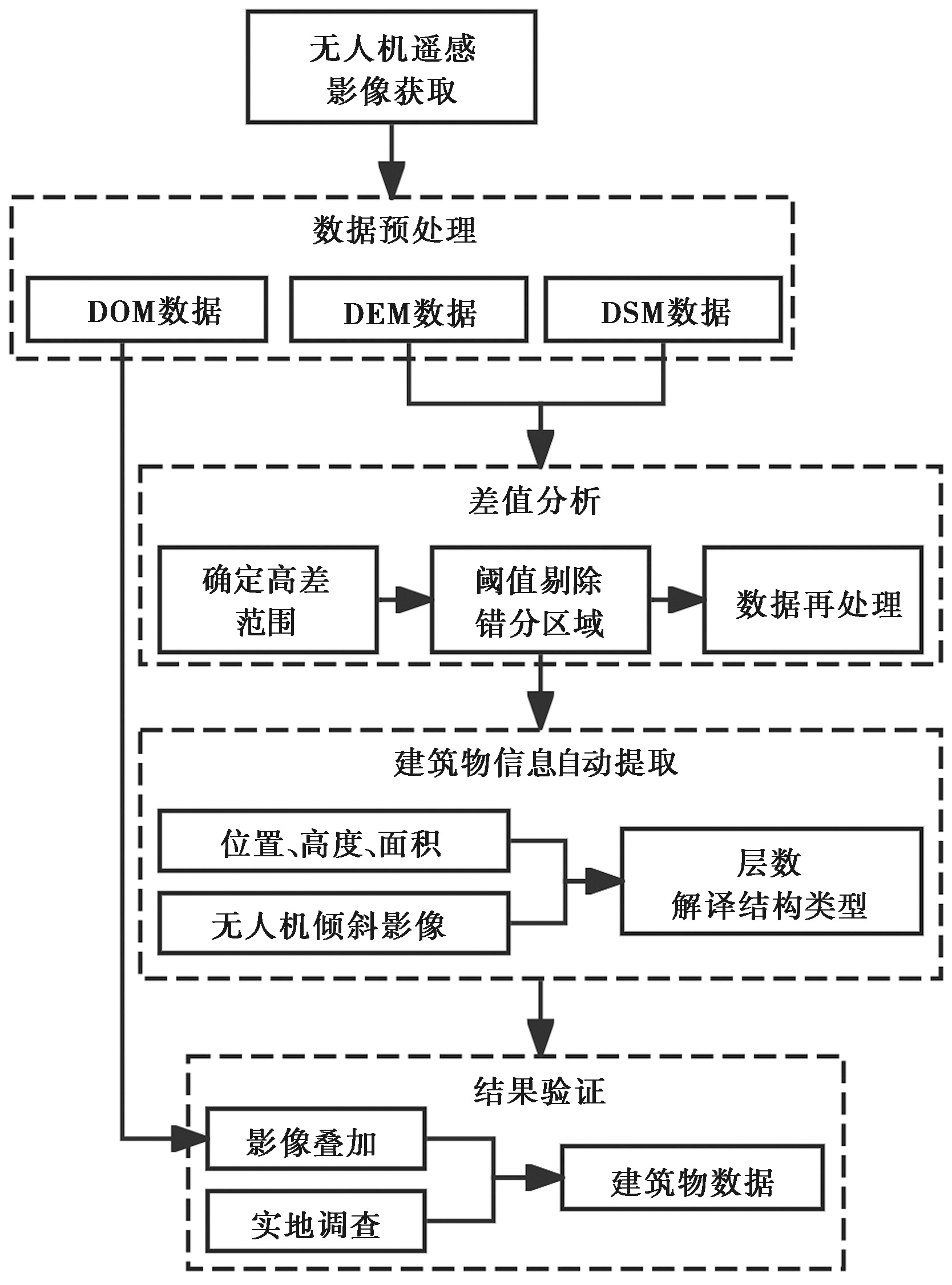
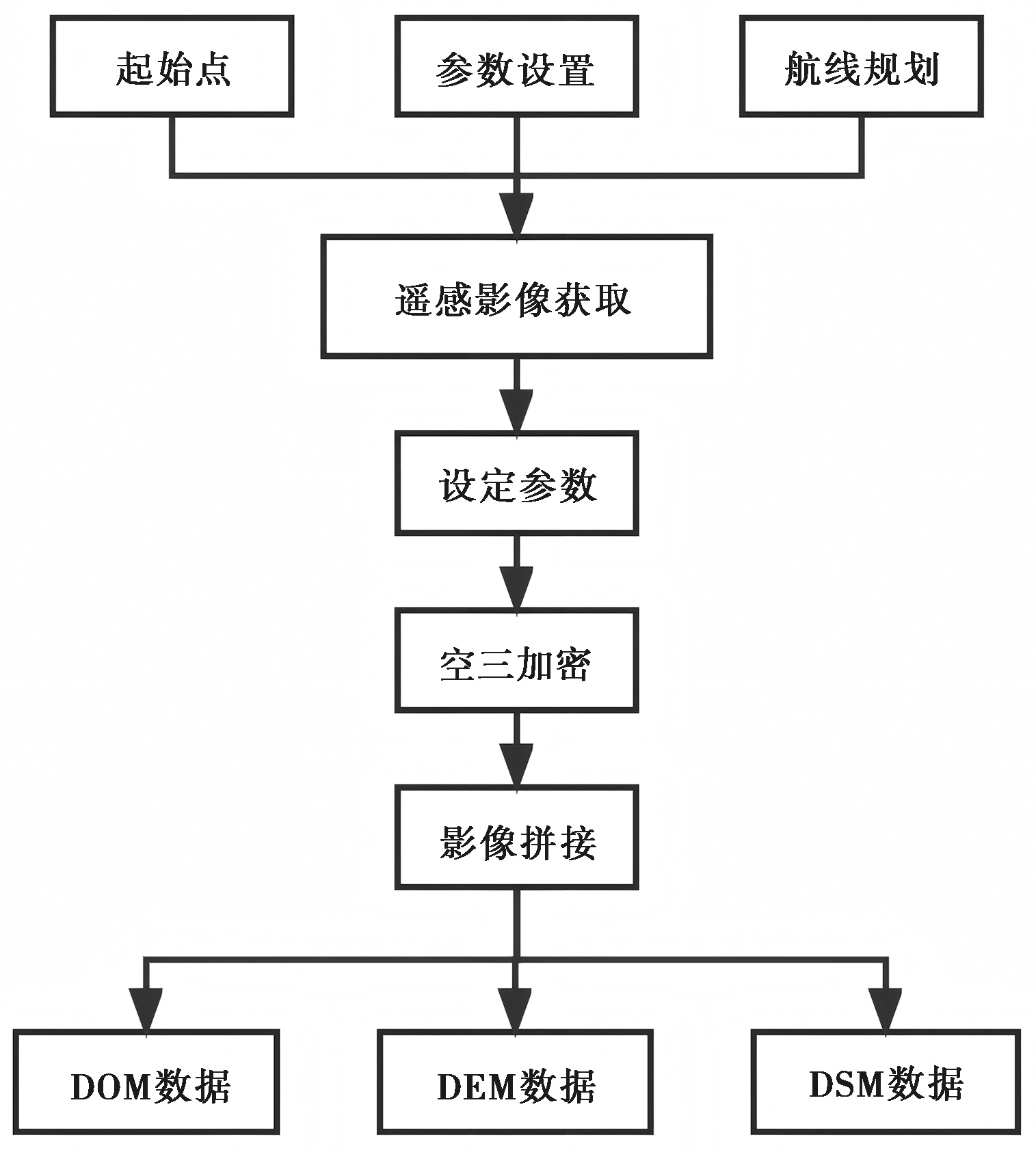
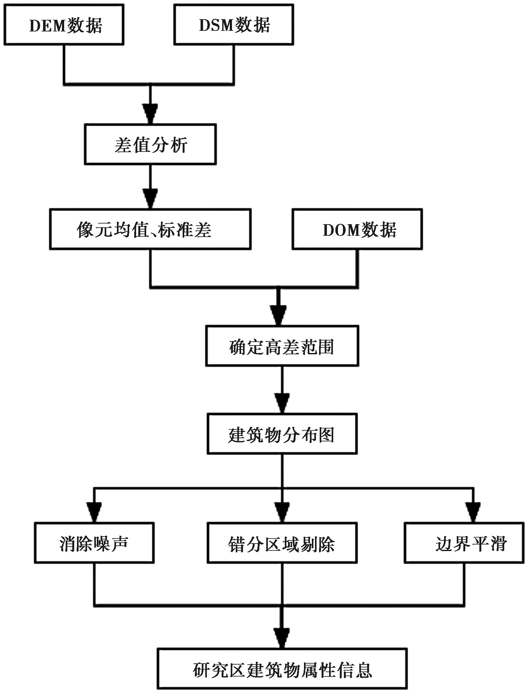
Because of the large number of houses in the pre-assessment area, it is impossible to complete the field investigation one by one. First, the visible light remote sensing image of the study area is obtained by UAV, and then the accurate extraction of building data is completed according to the steps of data preprocessing, difference analysis, automatic extraction of building information, and result verification. In data preprocessing, the digital surface model, elevation model and orthophoto data of the study area are generated through data analysis, parameter setting, spatial three-dimensional encryption, stitching and other steps. In the process of building data extraction, the extraction method based on elevation information is compared with the supervised classification method in terms of extraction efficiency and accuracy. The extraction method based on elevation information is based on the idea of making a difference between DSM and DEM. By making mean and standard deviation of pixels in different ranges, the height difference range is determined, and then the misclassified areas are eliminated according to the threshold. The error and noise problems are reprocessed to extract more accurate building information. In order to verify the accuracy of data extraction, in addition to superimposing and comparing the extracted images with DOM images, a field sampling survey was conducted to further verify the extracted results. In the proportion of housing structure types, the housing structure types are further interpreted by using the above housing extraction results and combining them with the field sampling survey, which is used for the output of pre-evaluation results.

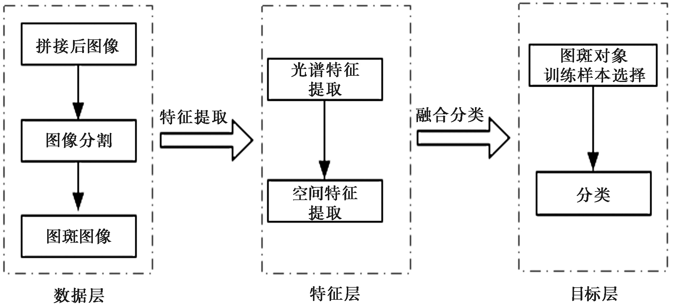
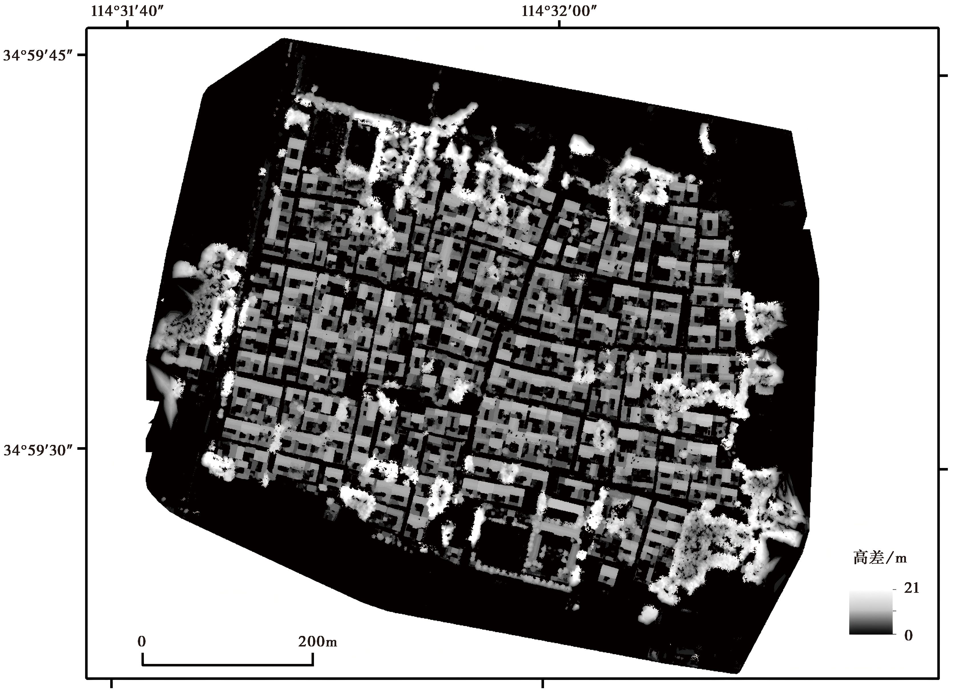
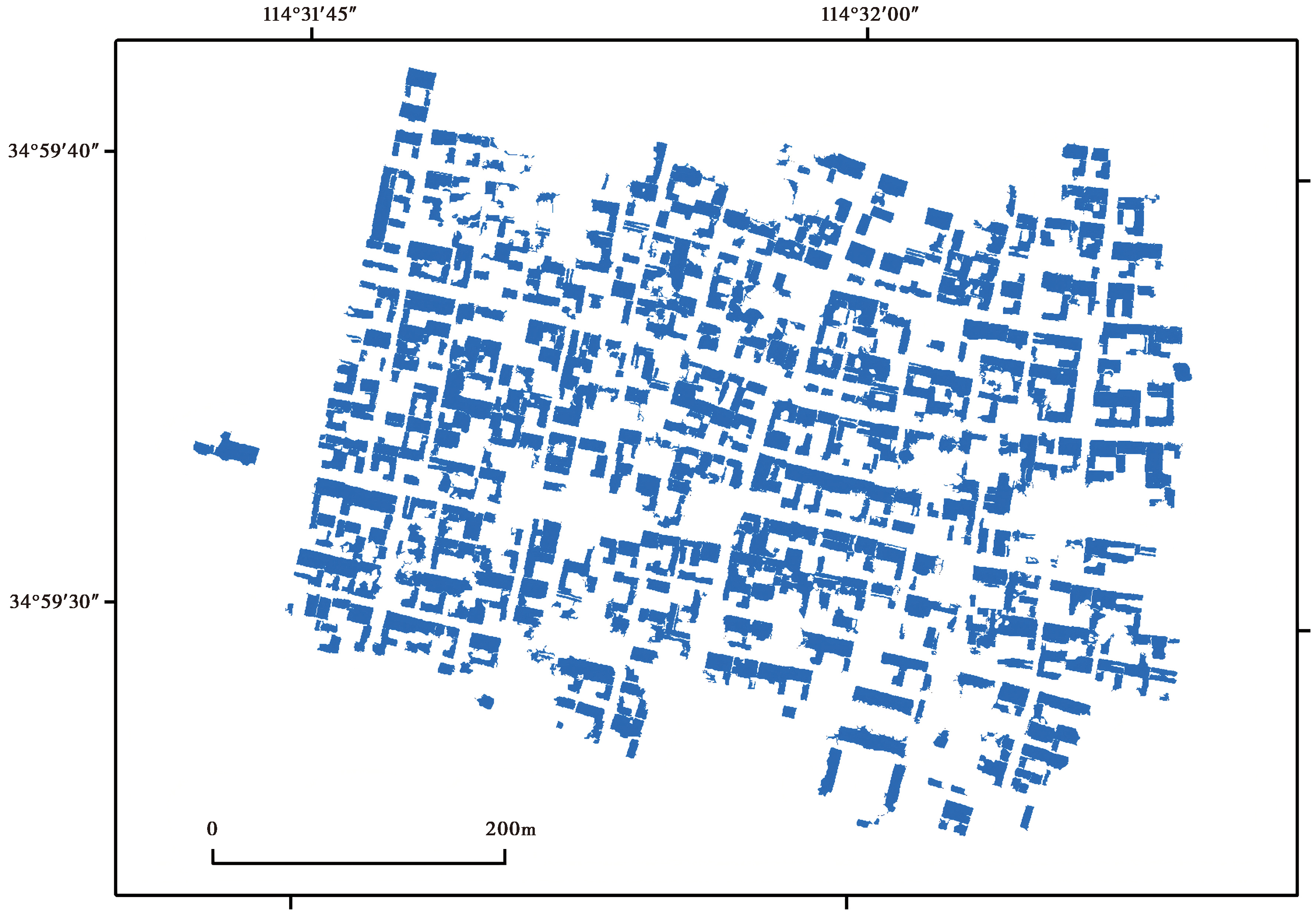
In the supervised classification method, building information is mainly obtained by identifying the building features in the DOM images. The results show that this method can extract buildings accurately, and the extracted building area is 94 051.3m2. However, there is a wrong extraction for cement roads with similar brightness and features to the roof, and there is a phenomenon of missing extraction for some old roof houses. In addition, the height information of buildings in this method can only be obtained by visual interpretation of inclined images in the same position, and then the number of buildings can be judged according to the interpreted height, and then the building area can be calculated. Based on the method of height difference extraction, in the difference analysis, the average and standard deviation of pixels are counted according to the height difference greater than 2 meters, and the range of height difference is determined to be 2.7 meters to 12 meters. Then, taking the house area as the reference value, the threshold value is set to 4.8m2 to eliminate the misclassified area. and the problems of error and noise are reprocessed, and finally, the house area was 80 566.8m2. The results show that this method is not only more accurate in extracting information, but also more convenient in obtaining the height, area and distribution position of houses. By comparing and analyzing the remote sensing images obtained by UAV with the results of the field investigation, the accuracy of house extraction is evaluated. The results show that the extraction accuracy of the method based on elevation information on the ground buildings is over 90%. Compared with the supervised classification method, there are relatively few misclassified areas, which can identify the building information more accurately. The extracted house information can be used to further interpret the proportion of houses with different structural types in the study area and improve the efficiency of interpretation.

In this study, rural areas are selected as the research area. To obtain accurate building data information in the research area, orthographic and oblique remote sensing images of the research area are collected by unmanned aerial vehicles, and two automatic extraction methods are compared and analyzed, which verifies the accuracy of the extraction methods. Compared with the supervised classification method, the extraction method based on elevation information adopted in this paper has higher reliability, higher extraction accuracy, and better extraction effect when the ground object type is complex. The overall extraction accuracy is not affected by the ground object type, and the building information in the research area can be extracted quickly and accurately. The extraction results can be used to interpret the area and proportion of buildings with different structural types, and can supplement and improve the spatial distribution database of buildings in the study area. This method realizes the automatic extraction of building information in the study area, improves the efficiency and accuracy of the pre-assessment work, and has been applied in the pre-assessment of earthquake disaster losses in rural areas of several districts and counties.

Key words: pre-assessment, building data, visible light remote sensing, elevation information, type of building structure

摘要:

地震灾害损失预评估是做好地震应急准备和降低灾害损失的重要内容, 而房屋建筑高度、面积、分布位置及结构类型数据是预评估工作的基础。为实现房屋建筑物数据的自动提取, 文中重点围绕农村地区房屋情况开展研究, 首先利用无人机获取研究区可见光遥感图像, 经预处理、设定参数、空三加密、拼接等步骤后, 生成研究区的数字表面模型、高程模型及正射影像数据。在房屋数据提取过程中, 从提取效率及精度的角度分别对比了基于高程信息的提取方法与监督分类方法, 其中基于高程提取的方法在差值分析中, 经统计像元均值和标准差, 确定高差范围为2.7~12m, 面积阈值设定为4.8m2, 提取面积约为80 566.8m2, 经对比分析, 提取精度达90%以上, 相较于监督分类方法在房屋面积、分布位置等方面效果更佳, 整体提取精度受地物类型影响不大。在房屋结构类型占比方面, 利用以上房屋提取结果, 结合实地抽样调查情况, 进一步解译房屋结构类型, 用于预评估结果的产出。文中采用的方法可应用于房屋建筑物数据的提取, 能提高地震灾害损失预评估工作的效率和精度。

关键词: 预评估, 建筑物数据, 可见光遥感, 高程信息, 房屋结构类型